Ramsey County is a county located in the U.S. state of Minnesota. As of the 2020 census, the population was 552,352, making it the second-most populous county in Minnesota. Its county seat and largest city is Saint Paul, the state capital and the twin city of Minneapolis. The county was founded in 1849 and is named for Alexander Ramsey, the first governor of the Minnesota Territory.

Arden Hills is a city in Ramsey County, Minnesota, United States. The population was 9,939 at the 2020 census. Bethel University and its seminary is located in the city of Arden Hills. Also, the campus of University of Northwestern – St. Paul straddles the Arden Hills – Roseville border. The city contains the headquarters of Land O'Lakes and Catholic United Financial, a fraternal benefit society. Boston Scientific also has a large campus within Arden Hills as well.

ASARCO is a mining, smelting, and refining company based in Tucson, Arizona, which mines and processes primarily copper. The company has been a subsidiary of Grupo México since 1999.

Interstate 694 (I-694) is an east–west auxiliary Interstate Highway located in the Minneapolis–Saint Paul metropolitan area in the US state of Minnesota. The western terminus of the route is at its junction with I-94, I-494, and US Highway 52 (US 52) in Maple Grove. The eastern terminus of I-694 is at its junction with I-94 and I-494 at the Woodbury–Oakdale city line. I-694 comprises the northern and northeastern portions of a beltway around the Twin Cities, with I-494 forming the remainder of the beltway. The speed limit is 60 mph (97 km/h). Interstate Highways outside of the loop in Minnesota may be signed as high as 70 mph (110 km/h) but can only reach 60 mph (97 km/h) inside the loop.
The Alabama Army Ammunition Plant (ALAAP), was a United States munitions plant built and operated during World War II. The facility is located four miles (6 km) north of Childersburg, Alabama in Talladega County, Alabama.

The Peters Cartridge Company was a company located along the Little Miami River in Kings Mills, Ohio, which specialized in gunpowder and ammunition production. Founded in 1887 by Gershom Moore Peters, the company supplied military ammunition to various countries during both world wars. Following its demise in 1944, the site was repurposed by Columbia Records and later Seagram, before being abandoned in 1968 and falling into disrepair. Its historic buildings, built in 1916, were added to the National Register of Historic Places in 1985. A brewery and apartment complex themed to the defunct company was constructed on site in 2020, in which many structures were restored and the company's history was placed on display for guests.

Minnesota State Highway 96 (MN 96) is a 10.179-mile-long (16.382 km) highway in Minnesota that runs from its intersection with U.S. Highway 61 in White Bear Lake and continues east to its eastern terminus at its intersection with State Highway 95 on the northern edge of Stillwater.

Weldon Spring Ordnance Works (WSOW) was a 17,323-acre (70.10 km2) U.S. Government-owned, contractor-operated (GOCO) facility in St. Charles County, Missouri, 55 km west of St. Louis. The site was originally operated by the Atlas Powder Company during World War II from 1941 to 1945 to produce explosives. The Atomic Energy Commission acquired part of the property in 1955, and Mallinckrodt, Inc. processed uranium ore from 1957 to 1966 under contract. The site has been divided into several parcels, and ownership has transferred over the years. Two portions of the original WSOW property are now Superfund sites that require substantial cleanup efforts. The environmental remediation of the WSOW site is currently designated as a major project of the Defense Environmental Restoration Program of the United States Department of Defense. Part of the original property is still used by the Army Reserve as the Weldon Spring Training Area.

Joliet Army Ammunition Plant (JOAAP, formerly known as the Joliet Arsenal) was a United States Army arsenal located in Will County, Illinois, near Elwood, Illinois, south of Joliet, Illinois. Opened in 1940 during World War II, the facility consisted of the Elwood Ordnance Plant (EOP) and the Kankakee Ordnance Works (KNK). In 1945, the two were deactivated and combined forming the Joliet Arsenal. The plant was reactivated for the Korean War and renamed Joliet Army Ammunition Plant during the Vietnam War. Production of TNT ended in 1976, and the major plant operations closed shortly after in the late 1970s. The facility briefly revived an automated load-assemble-pack (LAP) artillery shell operation that was managed by the Honeywell Corporation during the Reagan administration in the 1980s before it was finally closed.
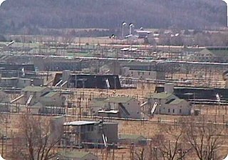
The Badger Army Ammunition Plant or Badger Ordnance Works (B.O.W.) is an excess, non-BRAC, United States Army facility located near Sauk City, Wisconsin. It manufactured nitrocellulose-based propellants during World War II, the Korean War, and the Vietnam War. It was a large munitions factory during World War II. As of 2013, the facility was in the end stages of demolition and remediation in preparation for property transfer.
The Denver Federal Center, in Lakewood, Colorado, is part of the General Services Administration and is home to about 6,200 employees of agencies of the federal government of the United States. The Center encompasses an area of about 670 acres (2.7 km2) and has 90 buildings with over 4,000,000 square feet (400,000 m2) of office, warehouse, lab and special use space. There are 28 different Federal agencies on-site, making it the largest concentration of Federal agencies outside of Washington, D.C.

Lake City Army Ammunition Plant (LCAAP) is a 3,935-acre (15.92 km2) U.S. government-owned, contractor-operated facility in northeastern Independence, Missouri, that was established by Remington Arms in 1941 to manufacture and test small caliber ammunition for the U.S. Army. The facility has remained in continuous operation except for one 5-year period following World War II. As of July 2007, the plant produced nearly 1.4 billion rounds of ammunition per year. In addition, Lake City performs small caliber ammunition stockpile reliability testing and has ammunition and weapon testing responsibilities as the NATO National and Regional Test Center. LCAAP is the single largest producer of small arms ammunition for the United States Armed Forces.
The Iowa Army Ammunition Plant (IAAAP), located in Des Moines County in southeastern Iowa, near the city of Burlington, produces and delivers component assembly, and medium- and large-caliber ammunition items for the United States Department of Defense using modern production methods in support of worldwide operations. The facility is part of the US Army Joint Munitions Command.
The Longhorn Army Ammunition Plant (LOW) was a 8,493-acre (34.37 km2) government-owned, contractor-operated (GOCO) facility in Karnack, Texas that was established in 1942. The Monsanto Chemical Company selected the site in December 1941 to produce TNT. The plant produced 393,000,000 pounds of TNT throughout World War II. After the signing of the Intermediate-Range Nuclear Forces Treaty on December 8, 1987, the Longhorn plant was used to destroy Pershing 1a and Pershing II missiles. The plant was operated by Thiokol.
The Lone Star Army Ammunition Plant was a 15,546-acre (62.91 km2) government-owned, contractor-operated (GOCO) facility 12 miles west of Texarkana, Texas that was established in 1942. The land was purchased from local citizens through Eminent Domain by the United States Department of Defense. The Lone Star Defense Corporation, a subsidiary of the B. F. Goodrich Rubber Corporation, won the contract on July 23, 1941 to produce artillery shells, bombs, fuses, boosters, and other auxiliary munitions at the site. The plant produced ammunition throughout World War II, the Korean War and the Vietnam War. The plant was last operated by Day & Zimmermann.
The Kansas Army Ammunition Plant was a 13,727-acre (55.55 km2) government-owned, contractor-operated (GOCO) facility, established in 1942, located near Parsons, Kansas. The plant produced ammunition during World War II, the Korean War, and the Vietnam War. The plant was deactivated on March 4, 2009 as part of the Base Realignment and Closure, 2005.
The Nebraska Ordnance Plant is a former United States Army ammunition plant located approximately ½ mile south of Mead, Nebraska and 30 miles west of Omaha, Nebraska in Saunders County. It originally extended across 17,250 acres (69.8 km2) producing weapons from 1942-45 after which the Army used it as a bomb factory during the Vietnam War. Environmental investigations in the 1980's found the soil and groundwater contaminated with the explosive RDX and the degreaser trichloroethylene. In 1990, federal agencies added the site to the National Priorities List as a Superfund site. Remediation included soil excavation and water treatment, the latter of which has been ongoing since 1997. Water is contained and treated at 4 treatment plants and the known plumes are monitored at hundreds of wells. The latest wells, dug deeper into the bedrock than previously, showed RDX and TCE above desired action levels in April 2016.
The Cornhusker Army Ammunition Plant was built by the US army beginning in 1942 to produce munitions during World War II. The plant produced munitions during World War II, the Korean War, and the Vietnam War. It is located 6 miles (10 km) west of Grand Island, Nebraska. It is currently an EPA Superfund site because of groundwater contamination by explosives and soil contamination by explosives and heavy metals. The plant occupies 12,042 acres (4,873 ha).


