The National Register of Historic Places (NRHP) is the United States federal government's official list of districts, sites, buildings, structures, and objects deemed worthy of preservation for their historical significance or "great artistic value". A property listed in the National Register or located within a National Register Historic District, may qualify for tax incentives derived from the total value of expenses incurred in preserving the property.
Monocacy National Battlefield is a unit of the National Park Service, the site of the Battle of Monocacy in the American Civil War fought on July 9, 1864. The battlefield straddles the Monocacy River southeast of the city of Frederick, Maryland. The battle, labeled "The Battle That Saved Washington," was one of the last the Confederates would carry out in Union territory. The two opposing leaders were General Jubal Early, fighting for the South, and General Lew Wallace, fighting for the North.
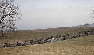
Antietam National Battlefield is a National Park Service-protected area along Antietam Creek in Sharpsburg, Washington County, northwestern Maryland. It commemorates the American Civil War Battle of Antietam that occurred on September 17, 1862.

This is a list of sites in Minnesota which are included in the National Register of Historic Places. There are more than 1,700 properties and historic districts listed on the NRHP; each of Minnesota's 87 counties has at least 2 listings. Twenty-two sites are also National Historic Landmarks.

This is a list of the buildings, sites, districts, and objects listed on the National Register of Historic Places in American Samoa. There are currently 31 listed sites spread across the three districts of American Samoa. There are no sites listed on the unorganized atoll of Swains Island.

This is a list of more than 1,100 properties and districts in Nebraska that are on the National Register of Historic Places. Of these, 20 are National Historic Landmarks. There are listings in 90 of the state's 93 counties.

There are 461 properties and historic districts listed on the National Register of Historic Places in North Dakota. There are listings in 52 of North Dakota's 53 counties.
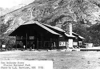
Two Medicine Store, formerly part of Two Medicine Chalets, is a historic building in Glacier National Park in the U.S. state of Montana. The chalet was originally built in 1914 by the Glacier Park Hotel Company, a subsidiary of the Great Northern Railway, as part of the railway's extensive program of visitor services development at Glacier. The chalet group originally featured a complex of log buildings, all built in the rustic style, which provided dining and lodging facilities. Overnight accommodations at the chalet ended with the onset of World War II, and the other buildings at the site were intentionally burned in 1956.
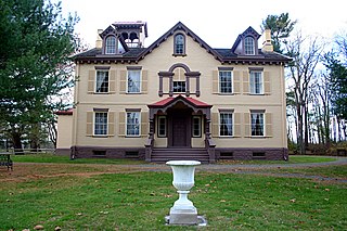
Martin Van Buren National Historic Site is a unit of the United States National Park Service in Columbia County, New York, 1 mile (1.6 km) south of the village of Kinderhook, 125 miles (201 km) north of New York City and 20 miles (32 km) south of Albany. The National Historic Site preserves the Lindenwald estate owned by Martin Van Buren, the eighth president of the United States. Van Buren purchased the 36-room mansion during his presidency in 1839, and it became his home and farm from his leaving office in 1841 until his death in 1862.
The history of the National Register of Historic Places began in 1966 when the United States government passed the National Historic Preservation Act (NHPA), which created the National Register of Historic Places (NRHP). Upon its inception, the U.S. National Park Service (NPS) became the lead agency for the Register. The Register has continued to grow through two reorganizations, one in the 1970s and one in 1980s and in 1978 the NRHP was completely transferred away from the National Park Service, it was again transmitted to the NPS in 1981.

Camp Disappointment is the northernmost campsite of the Lewis and Clark Expedition, on its return trip from the Pacific Northwest. The site is on private land within the Blackfeet Indian Reservation in Glacier County, Montana. It is located along the south bank of Cut Bank Creek and 12 miles (19 km) northeast of Browning, Montana. Glacier National Park can be seen in the distance.
The Edward H. White II Museum of Aerospace Medicine was a museum of the United States Air Force and was located in Hangar 9 at Brooks Air Force Base, San Antonio, Texas. Brooks Air Force Base closed in 2011 under Base Realignment and Closure Commission (BRAC) procedures, and the museum closed at the same time.

The Academy of Medicine in midtown Atlanta, Georgia, was built in 1941 and housed the Medical Association of Atlanta until the 1970s. The building is listed on the National Register of Historic Places, and is also designated as a historic building by the City of Atlanta. It is currently owned by the Georgia Institute of Technology.

Wolf Mountains Battlefield/Where Big Crow Walked Back and Forth was the site of the Battle of Wolf Mountain, the last major combat of the Great Sioux War of 1876–77. It was added to the National Register of Historic Places in 2001, and was designated a National Historic Landmark in 2008.

This is a list of the National Register of Historic Places listings in Stearns County, Minnesota. It is intended to be a complete list of the properties and districts on the National Register of Historic Places in Stearns County, Minnesota, United States. The locations of National Register properties and districts for which the latitude and longitude coordinates are included below, may be seen in an online map.

This is a list of the National Register of Historic Places listings in Big Horn County, Wyoming.
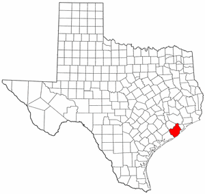
This is a list of the National Register of Historic Places listings in Brazoria County, Texas.

Medicine Lodge State Archeological Site is a Wyoming state park that interprets the Medicine Lodge Creek Site, a prehistoric Native American archeological site near Hyattville, Wyoming. It is administered by the Wyoming Division of State Parks and Historic Sites. The site is at the base of a steep limestone outcropping near the point where the dry and running portions of Medicine Lodge Creek join. for a protected location with ready access to water. The site includes petroglyphs and pictographs on the rock face. Excavations starting in the 1970s have found twelve levels of habitation in 10.5 feet of stratum, ranging from historic times to 8300 years before the present. The site comprises a portion of the former Wickwire Ranch, which was purchased by the state in 1972 and became to Medicine Lodge Wildlife Habitat Management Area of 12,000 acres (4,900 ha). The archeological site was designated in 1973. The site is managed as a state park, with campgrounds and a visitor center. It was added to the National Register of Historic Places on July 5, 1973.

