Virtual Singapore

Last updated
Virtual Singapore (VSg)
Virtual Singapore Logo.webp
SloganThe 'Digital Twin' of Singapore
Type of project Research
Owner Singapore Land Authority, National Research Foundation Singapore, Government of Singapore
Country Singapore
LaunchedDecember 3, 2014;9 years ago (2014-12-03)
Website Official website

Virtual Singapore is a 3D digital model of Singapore that uses real-time and topographical data. It is a digital twin of the city-state, and the first digital twin of a country. Virtual Singapore is co-led by the National Research Foundation, the Singapore Land Authority (SLA) and the Government Technology Agency. The Government of Singapore used Dassault Systèmes' 3DEXPERIENCE City to create the digital model.

Contents

Virtual Singapore was first launched on December 3, 2014, as part of Singapore's Smart Nation drive, [1] and was completed in 2022. [2]

Development

SLA began developing a 3D national map in 2012 to help the country make better use of its limited land and identify areas at risk of flooding. The Government of Singapore launched a 3D mapping program in 2011 after a flood occurred in the country after a very heavy downpour. The first map of the Virtual Singapore project was completed in 2014. [3]

“Indirectly, it started with the idea of digitizing a city,” stated Ingeborg Rocker, Vice President of the 3DEXPERIENCE City project. Rocker had resigned from Harvard University to work on the Virtual Singapore project. [4]

In 2014, LA began a 3D national mapping effort to create a Singapore Advanced Map that would depict the complicated urban environment in great detail and help in the development of endless space from restricted land. The project's ethical high-resolution and open-source map data offer a digital framework for the Smart Nation. It also aids in transitioning to a 3D-enabled Smart Nation, where data would be used in applications such as national security, urban development, climate change adaptation, etc. [5]

The Singapore Land Authority spearheaded the program to construct and maintain a high resolution 3D map of the country. It was funded half by the Government of Singapore and half by agencies, principally the Civil Aviation Authority of Singapore and the Public Utilities Board. The project required the collecting of massive amounts of data in various formats totaling more than 50 terabytes. The Singapore Land Authority hired the AAM Group to conduct airborne and land surveys to collect data. [6]

Phases

The project was divided into two phases.

During Phase one, aerial photography and airborne LiDAR were utilized in the first phase to record the country's topographical and surface data and develop digital models, which served as the overarching framework for the Singapore Advanced Map.

Phase two had vehicle-mounted laser scans to augment the aerial footage with street level data as part of the project's second phase, considerably improving map detail. A vehicle-based mobile mapping survey of the nation's 5500 kilometer road network was done to acquire more than three million photos, as well as build extremely detailed 3D models of the congested urban highway system. Bentley Systems' MicroStation's quickest data gathering and manipulation capabilities were employed to achieve a modeling accuracy of 0.3 metres and save over 3000 resource days and related expenditures. [7]

Purpose

Ng Siau Yong, Director of the Geospatial Division at the Singapore Land Authority, had stated that Virtual Singapore "aims to synergize all the 3D efforts from various agencies of the Government onto a common platform, so that, all public agencies can make use of a common 3D digital city model of Singapore." [8]

Virtual Singapore finding the volume, perimeter and area of an irregularly-shaped building VS finding perimeter, area and volume of an irregularly shaped building.png
Virtual Singapore finding the volume, perimeter and area of an irregularly-shaped building

Urban planning and design

Virtual Singapore serves as an opportunity to urban planners and architects. The three-dimensional digital twin allows these professionals to visualize the cityscape in intricate detail, experiment with different architectural and infrastructure scenarios, and assess the potential impact of proposed changes on the urban environment. This aids in the creation of more efficient and aesthetically pleasing urban spaces. [9]

Infrastructure

The digital model facilitates the simulation of infrastructure projects such as roads, bridges, buildings, and utilities. By virtually constructing and testing these elements before implementation, planners can optimize designs, anticipate challenges, and make informed decisions to enhance the overall efficiency and sustainability of the city's infrastructure.

Transport optimization

Virtual Singapore provides a platform for simulating and optimizing transportation systems. This includes analyzing traffic flow, testing different public transportation strategies, and identifying potential congestion points. By understanding how changes in transportation infrastructure impact the city, authorities can make data-driven decisions to improve mobility and reduce congestion.

Disaster management and resilience

The digital twin is instrumental in disaster management and resilience planning. It allows authorities to simulate and plan for various disaster scenarios, such as floods, earthquakes, or pandemics. By understanding how the city might be affected under different conditions, emergency response plans can be refined, and resilience strategies can be developed to mitigate the impact of potential disasters. [10]

Environmental monitoring

Virtual Singapore facilitates real-time monitoring and analysis of environmental factors. This includes tracking air quality, monitoring green spaces, and assessing the impact of urbanization on the ecosystem. The data gathered helps in formulating strategies for sustainable development, minimizing environmental impact, and fostering a healthier living environment for the city's residents. [11]

Smart City initiatives

The project aligns with the broader goals of transforming Singapore into a smart city. By integrating technologies like the Internet of Things (IoT) and data analysis, Virtual Singapore supports the deployment of smart city solutions. This includes initiatives such as smart grids, intelligent street lighting, and other innovations aimed at improving overall quality of life for residents. [12]

Accessibility

Virtual Singapore is accessible to many research institutes and university labs, such as the Government’s Agency for Science, Technology and Research and the National University of Singapore. Alexander Parilusyan, Vice President at Dassault Systèmes stated that "They can use this model to do very large-scale simulations, like wind, noise, traffic simulation."

Parilusyan also adds that "In the future, citizens and businesses will also get access to Virtual Singapore." We are working on this topic with agencies to see what kind of data we can provide to this external platform." "For instance, companies could use Virtual Singapore to test driverless cars without placing them on heavy-traffic roads," the Government of Singapore has stated. [13]

Benefits to businesses

Companies can use Virtual Singapore to visualize how the city will develop and evolve in response to population growth, new construction, and other major events.

Virtual Singapore captures a large amount of data, which can help planners learn and share lessons about construction and infrastructure before they become expensive urban planning problems.

The platform allows stakeholders from different sectors to test solutions for effective planning and decision-making without taking too many risks.

Virtual Singapore can be used for flood risk analysis, opportunities for solar panels and green roofs, and examining the impact of wind load on vegetation.

Businesses can use the platform's wealth of data and information for business analytics, resource planning, and delivering specialized services. [14]

Related Research Articles

<span class="mw-page-title-main">CATIA</span> CAD/CAM/CAE commercial software suite

CATIA is a multi-platform software suite for computer-aided design (CAD), computer-aided manufacturing (CAM), computer-aided engineering (CAE), 3D modeling and product lifecycle management (PLM), developed by the French company Dassault Systèmes.

<span class="mw-page-title-main">Dassault Systèmes</span> French software company

Dassault Systèmes SE is a French multinational software corporation which develops software for 3D product design, simulation, manufacturing and other 3D related products.

<span class="mw-page-title-main">SolidWorks</span> Commonly used software for 3D modeling

SolidWorks is a brand within Dassault Systèmes that develops and markets solid modeling computer-aided design, computer-aided engineering, 3D CAD design and collaboration, analysis, and product data management software.

<span class="mw-page-title-main">NASA WorldWind</span> Open-source virtual globe

NASA WorldWind is an open-source virtual globe. According to the website, "WorldWind is an open source virtual globe API. WorldWind allows developers to quickly and easily create interactive visualizations of 3D globe, map and geographical information. Organizations around the world use WorldWind to monitor weather patterns, visualize cities and terrain, track vehicle movement, analyze geospatial data and educate humanity about the Earth." It was first developed by NASA in 2003 for use on personal computers and then further developed in concert with the open source community since 2004. As of 2017, a web-based version of WorldWind is available online. An Android version is also available.

A GIS software program is a computer program to support the use of a geographic information system, providing the ability to create, store, manage, query, analyze, and visualize geographic data, that is, data representing phenomena for which location is important. The GIS software industry encompasses a broad range of commercial and open-source products that provide some or all of these capabilities within various information technology architectures.

<span class="mw-page-title-main">3D scanning</span> Scanning of an object or environment to collect data on its shape

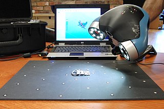
3D scanning is the process of analyzing a real-world object or environment to collect three dimensional data of its shape and possibly its appearance. The collected data can then be used to construct digital 3D models.

DELMIA, a brand within Dassault Systèmes, is a software platform designed for use in manufacturing and supply chain professionals. It offers various tools encompassing digital manufacturing, operations, and supply chain management, including simulation, planning, scheduling, modeling, execution, and real-time operations management.

<span class="mw-page-title-main">Building information modeling</span> Process used to design and document building and infrastructure designs

Building information modeling (BIM) is a process involving the generation and management of digital representations of the physical and functional characteristics of buildings and other physical assets. BIM is supported by various tools, technologies and contracts. Building information models (BIMs) are computer files which can be extracted, exchanged or networked to support decision-making regarding a built asset. BIM software is used by individuals, businesses and government agencies who plan, design, construct, operate and maintain buildings and diverse physical infrastructures, such as water, refuse, electricity, gas, communication utilities, roads, railways, bridges, ports and tunnels.

<span class="mw-page-title-main">Copernicus Programme</span> Programme of the European Commission

Copernicus is the Earth observation component of the European Union Space Programme, managed by the European Commission and implemented in partnership with the EU Member States, the European Space Agency (ESA), the European Organisation for the Exploitation of Meteorological Satellites (EUMETSAT), the European Centre for Medium-Range Weather Forecasts (ECMWF), the Joint Research Centre (JRC), the European Environment Agency (EEA), the European Maritime Safety Agency (EMSA), Frontex, SatCen and Mercator Océan.

<span class="mw-page-title-main">Green infrastructure</span> Sustainable and resilient infrastructure

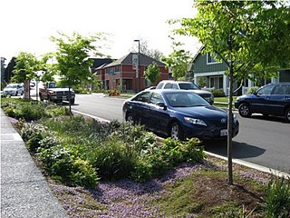
Green infrastructure or blue-green infrastructure refers to a network that provides the “ingredients” for solving urban and climatic challenges by building with nature. The main components of this approach include stormwater management, climate adaptation, the reduction of heat stress, increasing biodiversity, food production, better air quality, sustainable energy production, clean water, and healthy soils, as well as more anthropocentric functions, such as increased quality of life through recreation and the provision of shade and shelter in and around towns and cities. Green infrastructure also serves to provide an ecological framework for social, economic, and environmental health of the surroundings. More recently scholars and activists have also called for green infrastructure that promotes social inclusion and equity rather than reinforcing pre-existing structures of unequal access to nature-based services.

<span class="mw-page-title-main">Smart city</span> City using integrated information and communication technology

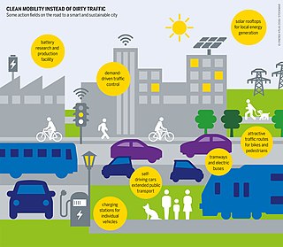
A smart city is a technologically modern urban area that uses different types of electronic methods and sensors to collect specific data. Information gained from that data is used to manage assets, resources and services efficiently; in return, that data is used to improve operations across the city. This includes data collected from citizens, devices, buildings and assets that is processed and analyzed to monitor and manage traffic and transportation systems, power plants, utilities, urban forestry, water supply networks, waste, criminal investigations, information systems, schools, libraries, hospitals, and other community services. Smart cities are defined as smart both in the ways in which their governments harness technology as well as in how they monitor, analyze, plan, and govern the city. In smart cities, the sharing of data is not limited to the city itself but also includes businesses, citizens and other third parties that can benefit from various uses of that data. Sharing data from different systems and sectors creates opportunities for increased understanding and economic benefits.

Collaborative mapping, also known as citizen mapping, is the aggregation of Web mapping and user-generated content, from a group of individuals or entities, and can take several distinct forms. With the growth of technology for storing and sharing maps, collaborative maps have become competitors to commercial services, in the case of OpenStreetMap, or components of them, as in Google Map Maker, Waze and Yandex Map Editor.

Hexagon Geospatial's GeoMedia Professional is a geographic information system (GIS) management solution for map generation and the analysis of geographic information with smart tools that capture and edit spatial data. GeoMedia is used for: creating geographic data; managing geospatial databases; joining business data, location intelligence and geographic data together; creating hard and soft-copy maps; conduct analysis in 'real-time'; base platform for multiple applications, geographic data validation, publishing geospatial information and analyzing mapped information.

<span class="mw-page-title-main">3D city model</span>

A 3D city model is digital model of urban areas that represent terrain surfaces, sites, buildings, vegetation, infrastructure and landscape elements in three-dimensional scale as well as related objects belonging to urban areas. Their components are described and represented by corresponding two- and three-dimensional spatial data and geo-referenced data. 3D city models support presentation, exploration, analysis, and management tasks in a large number of different application domains. In particular, 3D city models allow "for visually integrating heterogeneous geoinformation within a single framework and, therefore, create and manage complex urban information spaces."

NPA Satellite Mapping is the longest-established satellite mapping specialist in Europe, with expertise in geoscience applications of earth observation and remote sensing. In addition to processing and distributing data from a variety of optical and radar satellites, NPA specialises in added-value and derived products, providing validation and interpretation of satellite-based imagery.

<span class="mw-page-title-main">CityEngine</span> 3D modelling software

ArcGIS CityEngine is a commercial three-dimensional (3D) modeling program developed by Esri R&D Center Zurich and specialises in the generation of 3D urban environments. Using a procedural modeling approach, it supports the creation of detailed large-scale 3D city models. CityEngine works with architectural object placement and arrangement in the same manner that software like VUE manages terrain, ecosystems and atmosphere mapping. Unlike the traditional 3D modeling methodology which uses Computer-Aided Design (CAD) tools and techniques, CityEngine takes a different approach to shape generation via a rule-based system. It can also use Geographic Information System (GIS) datasets due to its integration with the wider Esri/ArcGIS platform. Due to this unique feature set, CityEngine has been used in academic research and built environment professions, e.g., urban planning, architecture, visualization, game development, entertainment, archeology, military and cultural heritage. CityEngine can be used within Building Information Model (BIM) workflows as well as visualizing the data of buildings in a larger urban context, enhancing its working scenario toward real construction projects.

Created in 1986, IGN FI is the private subsidiary of the French Institut Géographique National (IGN) and works essentially abroad. Its goal is to promote the savoir-faire of the French IGN around the world.

<span class="mw-page-title-main">Low-impact development (U.S. and Canada)</span>

Low-impact development (LID) is a term used in Canada and the United States to describe a land planning and engineering design approach to manage stormwater runoff as part of green infrastructure. LID emphasizes conservation and use of on-site natural features to protect water quality. This approach implements engineered small-scale hydrologic controls to replicate the pre-development hydrologic regime of watersheds through infiltrating, filtering, storing, evaporating, and detaining runoff close to its source. Green infrastructure investments are one approach that often yields multiple benefits and builds city resilience.

A digital twin is a digital model of an intended or actual real-world physical product, system, or process that serves as the effectively indistinguishable digital counterpart of it for practical purposes, such as simulation, integration, testing, monitoring, and maintenance. The digital twin is the underlying premise for Product Lifecycle Management and exists throughout the entire lifecycle of the physical entity it represents. Since information is detailed, the digital twin representation is determined by the value-based use cases it is created to implement. The digital twin can exist before the physical entity, as for example with virtual prototyping. The use of a digital twin in the creation phase allows the intended entity's entire lifecycle to be modeled and simulated. A digital twin of an existing entity may be used in real time and regularly synchronized with the corresponding physical system.

References

  1. Pereira, Daniel (2023-05-23). "Speculative Design: "Virtual Singapore" is a Massive, Fully Functional Digital Twin of the Asian City-State". OODA Loop. Retrieved 2024-01-14.
  2. Virtual Singapore , retrieved 2024-01-14
  3. Walker, Andy (2023-05-04). "Singapore's digital twin – from science fiction to hi-tech reality". Infrastructure Global. Retrieved 2024-01-14.
  4. "The Virtual Singapore project is mapping out an entire city in 3D". Digital Trends. 2017-10-19. Retrieved 2024-01-14.
  5. "Case Study | Virtual Singapore". GeoSLAM. Retrieved 2024-01-14.
  6. Prime, G. W. (2022-03-07). "Virtual Singapore – Building a 3D-Empowered Smart Nation". Geospatial World. Retrieved 2024-01-14.
  7. Prime, G. W. (2022-03-07). "Virtual Singapore – Building a 3D-Empowered Smart Nation". Geospatial World. Retrieved 2024-01-14.
  8. 3DEXPERIENCity® - Virtual Singapore: Singapore's Innovative City Project - Dassault Systèmes , retrieved 2024-01-14
  9. Virtual Singapore, Reuter(s). "Virtual Singapore project could be test bed for planners - and plotters". Reuters.
  10. "Virtual Singapore Is More Than Just a 3-D Model, It's an Intelligent Rendering of the City". GovTech. Retrieved 2024-01-14.
  11. Johnson, Lauren (2022-09-12). "Singapore's Digital Twin of Entire Country". TOMORROW’S WORLD TODAY®. Retrieved 2024-01-14.
  12. "Singapore: the world's smartest city | Thales Group". www.thalesgroup.com. 2023-02-20. Retrieved 2024-01-14.
  13. "Meet Virtual Singapore, the city's 3D digital twin". govinsider.asia. Retrieved 2024-01-14.
  14. Corke, Greg (2015-07-02). "NEWS: Dassault Systèmes helps build Virtual Singapore". AEC Magazine. Retrieved 2024-01-14.