Wade Hampton, South Carolina

Last updated
Wade Hampton, South Carolina
USA South Carolina location map.svg
Red pog.svg
Wade Hampton, South Carolina
Location of Wade Hampton, South Carolina
Coordinates: 34°52′59″N82°20′0″W / 34.88306°N 82.33333°W / 34.88306; -82.33333
CountryUnited States
State South Carolina
County Greenville
Area
[1]
  Total8.92 sq mi (23.10 km2)
  Land8.88 sq mi (23.01 km2)
  Water0.04 sq mi (0.09 km2)
Elevation
[2]
1,024 ft (312 m)
Population
 (2020) [3]
  Total21,482
  Density2,418.05/sq mi (933.66/km2)
Time zone UTC−5 (Eastern (EST))
  Summer (DST) UTC−4 (EDT)
FIPS code 45-73870 [4]
GNIS feature ID1245371 [2]

Wade Hampton is a census-designated place (CDP) in Greenville County, South Carolina, United States. The population was 20,622 at the 2010 census. [5] It is named for American Civil War general and South Carolina governor Wade Hampton.

Contents

Wade Hampton is part of the Greenville Mauldin Easley Metropolitan Statistical Area.

Geography

Wade Hampton is located in central Greenville County at 34°52′59″N82°20′0″W / 34.88306°N 82.33333°W / 34.88306; -82.33333 (34.883084, -82.333227). [6] It is bordered to the southwest by the city of Greenville and to the northeast by Taylors, an unincorporated community. U.S. Route 29 (Wade Hampton Boulevard) passes through the CDP, leading southwest 5 miles (8 km) to the center of Greenville and northeast 7 miles (11 km) to Greer.

According to the United States Census Bureau, the CDP has a total area of 9.0 square miles (23.3 km2), of which 9.0 square miles (23.2 km2) are land and 0.04 square miles (0.1 km2), or 0.55%, are water. [5]

Demographics

Historical population
CensusPop.Note
2020 21,482
U.S. Decennial Census [7]

2020 census

Wade Hampton racial composition [8]
RaceNum.Perc.
White (non-Hispanic)14,76268.72%
Black or African American (non-Hispanic)2,18610.18%
Native American 410.19%
Asian 6803.17%
Pacific Islander 180.08%
Other/Mixed 8734.06%
Hispanic or Latino 2,92213.6%

As of the 2020 United States census, there were 21,482 people, 9,016 households, and 5,368 families residing in the CDP.

2000 census

As of the census [4] of 2000, there were 20,458 people, 9,210 households, and 5,645 families residing in the CDP. The population density was 2,331.4 inhabitants per square mile (900.2/km2). There were 9,793 housing units at an average density of 1,116.0 per square mile (430.9/km2). The racial makeup of the CDP was 84.85% White, 8.08% African American, 0.18% Native American, 3.34% Asian, 0.06% Pacific Islander, 2.39% from other races, and 1.11% from two or more races. Hispanic or Latino of any race were 6.13% of the population.

There were 9,210 households, out of which 22.9% had children under the age of 18 living with them, 49.4% were married couples living together, 9.0% had a female householder with no husband present, and 38.7% were non-families. 32.7% of all households were made up of individuals, and 10.8% had someone living alone who was 65 years of age or older. The average household size was 2.21 and the average family size was 2.81.

In the CDP, the population was spread out, with 19.0% under the age of 18, 9.6% from 18 to 24, 28.9% from 25 to 44, 24.3% from 45 to 64, and 18.2% who were 65 years of age or older. The median age was 40 years. For every 100 females, there were 93.8 males. For every 100 females age 18 and over, there were 90.9 males.

The median income for a household in the CDP was $40,487, and the median income for a family was $54,106. Males had a median income of $40,528 versus $27,613 for females. The per capita income for the CDP was $26,376. About 6.4% of families and 9.0% of the population were below the poverty line, including 10.9% of those under age 18 and 5.3% of those age 65 or over.

Education

The French Bilingual School of South Carolina is located in Wade Hampton. [9] [10]

The Greenville Saturday School (グリーンビル日本語補習授業校 Gurīnbiru Nihongo Hoshū Jugyō Kō), a Japanese Saturday supplementary school, holds its classes at the French Bilingual School. [11] The school was scheduled to open in 1989. [12] The school received $2,500 from the city council of Greenville. [13]

Related Research Articles

<span class="mw-page-title-main">Hampton County, South Carolina</span> County in South Carolina, United States

Hampton County is a rural county located in the U.S. state of South Carolina. As of the 2020 census, the population was 18,561. Its county seat is Hampton. It was named for Confederate Civil War general Wade Hampton, who in the late 1870s, with the ending of Reconstruction, was elected as governor of South Carolina.

<span class="mw-page-title-main">Powdersville, South Carolina</span> Census-designated place in South Carolina, United States

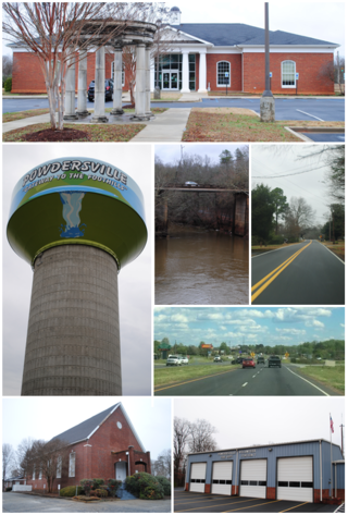
Powdersville is a census-designated place (CDP) in Anderson County, South Carolina, United States. The population was 7,618 at the 2010 census, up from 5,362 in 2000. Powdersville was initially a farming community until the increase in housing subdivisions and businesses along Highway 153.

<span class="mw-page-title-main">Berea, South Carolina</span> CDP in South Carolina, United States

Berea is a census-designated place (CDP) in Greenville County, South Carolina, United States. The population was 14,295 at the 2010 census. It is part of the Greenville–Mauldin–Easley Metropolitan Statistical Area.

<span class="mw-page-title-main">City View, South Carolina</span> Census-designated place in South Carolina, United States

City View, a former incorporated city, is now a census-designated place (CDP) in Greenville County, South Carolina, United States. The population was 1,345 at the 2010 census, up from 1,254 in 2000. It is part of the Greenville–Mauldin–Easley Metropolitan Statistical Area.

Duncan is a census-designated place (CDP) in Greenville County, South Carolina, United States. The population was 3,671 at the 2010 census, down from 4,158 in 2000. It is part of the Greenville–Mauldin–Easley Metropolitan Statistical Area.

Five Forks is a census-designated place (CDP) in Greenville County, South Carolina, United States. The population was 17,737 at the 2020 census, up from 14,140 in 2010, and 8,064 in 2000. It is a growing, affluent suburb of Greenville and is part of the Greenville–Mauldin–Easley Metropolitan Statistical Area.

<span class="mw-page-title-main">Gantt, South Carolina</span> Census-designated place in South Carolina, United States

Gantt is a census-designated place (CDP) in Greenville County, South Carolina, United States. The population was 14,229 at the 2010 census. It is part of the Greenville–Mauldin–Easley Metropolitan Statistical Area and a suburb of the city of Greenville.

<span class="mw-page-title-main">Golden Grove, South Carolina</span> Census-designated place in South Carolina, United States

Golden Grove is a census-designated place (CDP) in Greenville County, South Carolina, United States. The population was 2,467 at the 2010 census. It is part of the Greenville–Mauldin–Easley Metropolitan Statistical Area.

Judson is a census-designated place (CDP) in Greenville County, South Carolina, United States. The population was 2,050 at the 2010 census, down from 2,456 at the 2000 census. It is part of the Greenville–Mauldin–Easley Metropolitan Statistical Area.

Parker is a census-designated place (CDP) in Greenville County, South Carolina, United States. The population was 11,431 at the 2010 census, up from 10,760 in 2000. It is part of the Greenville–Mauldin–Easley Metropolitan Statistical Area.

Sans Souci is a census-designated place (CDP) in Greenville County, South Carolina, United States. The population was 7,869 at the 2010 census. It is part of the Greenville-Anderson-Mauldin, SC Metropolitan Statistical Area.

<span class="mw-page-title-main">Taylors, South Carolina</span> CDP in South Carolina, United States

Taylors is a census-designated place (CDP) in Greenville County, South Carolina, United States. The population was 21,617 at the 2010 census. Taylors is the Greenville/Spartanburg area's largest suburb although it is not incorporated as a city. It is part of the Greenville–Mauldin–Easley Metropolitan Statistical Area. The area serves as the result of urban sprawl in the Greenville metropolitan city.

<span class="mw-page-title-main">Welcome, South Carolina</span> Census-designated place in South Carolina, United States

Welcome is a census-designated place (CDP) in Greenville County, South Carolina, United States. The population was 6,668 at the 2010 census. It is part of the Greenville–Mauldin–Easley Metropolitan Statistical Area. Welcome has been noted for its colorful place name.

<span class="mw-page-title-main">Hampton, South Carolina</span> Town in South Carolina, United States

Hampton is a town in Hampton County, South Carolina, United States. The population was 2,808 at the 2010 census. It is the county seat of Hampton County. The town and the county are named after Wade Hampton III, a Confederate general in the Civil War.

Varnville is a town in Hampton County, South Carolina, United States. The population was 2,162 as of the 2010 census. Varnville forms a twin town with Hampton, the county seat; the two towns often share civic and cultural events.

<span class="mw-page-title-main">Joanna, South Carolina</span> Census-designated place in South Carolina, United States

Joanna is an unincorporated community and census-designated place (CDP) in Laurens County, South Carolina, United States. The population was 1,539 at the 2010 census, down from 1,609 at the 2000 census. It is part of the Greenville–Mauldin–Easley Metropolitan Statistical Area.

<span class="mw-page-title-main">Mountville, South Carolina</span> Census-designated place in South Carolina, United States

Mountville is an unincorporated community and census-designated place (CDP) in Laurens County, South Carolina, United States. The population was 108 at the 2010 census, down from 130 at the 2000 census. It is part of the Greenville–Mauldin–Easley Metropolitan Statistical Area.

<span class="mw-page-title-main">Princeton, South Carolina</span> Census-designated place in South Carolina, United States

Princeton is an unincorporated community and census-designated place (CDP) in Laurens County, South Carolina, United States. The population was 62 at the 2010 census. It is part of the Greenville–Mauldin–Easley Metropolitan Statistical Area.

<span class="mw-page-title-main">St. Andrews, South Carolina</span> Census-designated place in South Carolina, United States

St. Andrews is a census-designated place (CDP) in Richland County, South Carolina, United States. The population was 20,493 at the 2010 census. It is part of the Columbia, South Carolina Metropolitan Statistical Area.

<span class="mw-page-title-main">Piedmont, South Carolina</span> Census-designated place in South Carolina, United States

Piedmont is a census-designated place (CDP) along the Saluda River in Anderson and Greenville counties in the U.S. state of South Carolina. The population was 5,411 at the 2020 census.

References

  1. "ArcGIS REST Services Directory". United States Census Bureau. Retrieved October 15, 2022.
  2. 1 2 U.S. Geological Survey Geographic Names Information System: Wade Hampton, South Carolina
  3. "Census Population API". United States Census Bureau. Retrieved Oct 15, 2022.
  4. 1 2 "U.S. Census website". United States Census Bureau . Retrieved 2008-01-31.
  5. 1 2 "Geographic Identifiers: 2010 Demographic Profile Data (G001): Wade Hampton CDP, South Carolina". American Factfinder. U.S. Census Bureau. Retrieved February 15, 2017.[ dead link ]
  6. "US Gazetteer files: 2010, 2000, and 1990". United States Census Bureau. 2011-02-12. Retrieved 2011-04-23.
  7. "Census of Population and Housing". Census.gov. Retrieved June 4, 2016.
  8. "Explore Census Data". data.census.gov. Retrieved 2021-12-14.
  9. "FRENCH BILINGUAL SCHOOL OF SOUTH CAROLINA" (Archive) Association of French Schools in America. Retrieved on May 11, 2014. "Address: 2 Fisher road City: Greenville, SC State/Province: SC, 29615"
  10. "2010 CENSUS - CENSUS BLOCK MAP: Wade Hampton CDP, SC" (Archive). U.S. Census Bureau. Retrieved on May 11, 2014.
  11. "GSSへのDirection" (Archive). Greenville Saturday School. Retrieved on May 11, 2014.
  12. "Greenville school to meet need of Japanese youths". The State . Columbia, South Carolina. Associated Press. 1988-12-30. p. 4-C. - Clipping from Newspapers.com.
  13. "Japanese Kids Get Saturday School". The Charlotte Observer . Charlotte, North Carolina. Associated Press. 1988-12-29. pp. 1C, 4C. - Clipping of first and of second page from Newspapers.com.