Greer, South Carolina

Last updated

Greer
Greer 2.jpg
Downtown Greer
City of Greer logo.jpg
Motto(s): 
"A Great Place to Live, Work, and Play"
Greer, South Carolina
Interactive map of Greer
USA South Carolina relief location map.svg
Red pog.svg
Greer
Location within South Carolina
Usa edcp relief location map.png
Red pog.svg
Greer
Location within the United States
Coordinates: 34°55′49″N82°13′30″W / 34.93028°N 82.22500°W / 34.93028; -82.22500
CountryUnited States
State South Carolina
Counties Greenville, Spartanburg
Founded1876
Named for James Manning Greer [1]
Government
  TypeCouncil (weak mayor)
  MayorRick Danner
  City AdministratorAndy Merriman
  Number of City Council members6
Area
[2]
  Total25.56 sq mi (66.20 km2)
  Land23.44 sq mi (60.71 km2)
  Water2.12 sq mi (5.49 km2)  8.29%
Elevation
[3]
1,014 ft (309 m)
Population
 (2020) [4]
  Total35,308
  Estimate 
(2023)
44,387
  Density1,506.38/sq mi (581.62/km2)
Time zone UTC−5 (Eastern (EST))
  Summer (DST) UTC−4 (EDT)
ZIP codes
29650-29652
Area code 864
FIPS code 45-30985 [5]
GNIS feature ID1245847 [3]
Website www.cityofgreer.org

Greer is a city in Greenville and Spartanburg counties in the U.S. state of South Carolina. The population was 35,308 as of the 2020 census, making it the 14th-most populous city in South Carolina. [6] Greer is included in the Greenville-Anderson-Greer, SC Metropolitan Statistical Area, which is part of the Greenville-Spartanburg-Anderson, SC Combined Statistical Area in Upstate South Carolina. [7]

Contents

History

Greer was named for James Manning Greer, whose ancestry traces from Scotland, through Ireland. Many of his descendants still reside in the region. James Manning Greer was a descendant of John Greer Sr., who surveyed his land in Laurens County in 1750. John and his family were already in Laurens County, prior to the Greer passengers who arrived aboard the ship The Falls in 1764. John Greer's family settled at Duncans Creek between that Creek and the Enoree River and close to Duncan's Creek Presbyterian Church. John, Sr.'s great grandson James Manning Greer settled his family near Greenville in an area that eventually became Greer's Station. [8] [9]

Greer Downtown Historic District Greer Downtown Historic District.jpg
Greer Downtown Historic District

The area now known as Greer was once part of the "Domain of the Cherokees" prior to the American Revolutionary War. In 1777, the area was added to the state of South Carolina. Development toward the birth of the town occurred in 1873, when the Richmond and Danville Air Line Railway (now the Norfolk Southern Railway) established a line between Atlanta and Charlotte. A station was built on land that belonged to James Manning Greer, and was named Greer's Station. The first post office was located in the new depot, Greer's Depot. [8] That depot was a red brick, Victorian structure with a slate roof and a cupola. It was located immediately adjacent to the current Norfolk Southern rail line between Trade Street and Depot Street, facing toward Moore Street. It was demolished in 1976 by its then owner, the Southern Railway System, in order to avoid property taxes. When the town was incorporated in 1876, it was named Town of Greer's. One hundred years later, the name was officially changed to the City of Greer without an "s" on the end. [10] [11] [12]

Merchants, blacksmiths and physicians set up shop in what is now the downtown area of Greer. In 1900, Greer's first bank, the Bank of Greer's, opened. The Piedmont and Northern Railway laid a second railroad line through Greer in 1914. With two active train lines, Greer became an attractive site for commerce. The railway meant big business for local farmers, enabling them to ship their crops, mainly cotton and peaches, out of state. Greer also became a textile-manufacturing center, with flourishing mills that included Victor, Franklin, Apalache and Greer Mills. The communities that grew up around the mills were as close-knit as the outlying farming communities. [8] [9]

In 1939, artist Winfred Walkley painted a mural, Cotton and Peach Growing, for the town's old post office as one of thirteen works commissioned by the U.S. Treasury Department's Section of Fine Arts between 1938 and 1941 for post offices and federal buildings throughout South Carolina. [13] The building is now home to the Greer Heritage Museum. [14]

After World War II, the city began to grow and diversify its industrial base. A new hospital and high school were built. People came to downtown Greer from Spartanburg and Greenville to shop. In the early 1960s, Interstate 85 was opened, as well as the Greenville-Spartanburg International Airport. Imports derailed the textile industry in the 1970s and threatened to turn Greer into a ghost town, but the citizens of Greer worked together to attract new industry. [15]

Geography

Greer is located 12 miles (19 km) northeast of Greenville and 17 miles (27 km) west of Spartanburg.

According to the United States Census Bureau, the city has a total area of 25.56 square miles (66.2 km2), of which 23.44 square miles (60.7 km2) is land and 2.12 square miles (5.5 km2) (8.29%) is water. [2] Greer has three lakes: Apalache Lake, Lake Robinson, and Lake Cunningham. The South Tyger River runs through the northern part of Greer, part of the Broad River watershed.

Demographics

Historical population
CensusPop.Note
1880 97
1890 320229.9%
1900 648102.5%
1910 1,673158.2%
1920 2,29237.0%
1930 2,4195.5%
1940 2,94021.5%
1950 5,05071.8%
1960 8,96777.6%
1970 10,64218.7%
1980 10,525−1.1%
1990 10,322−1.9%
2000 16,84363.2%
2010 25,51551.5%
2020 35,30838.4%
2023 (est.)44,387 [6] 25.7%
U.S. Decennial Census [16] [4]

2020 census

Greer racial composition [17]
RaceNum.Perc.
White (non-Hispanic)20,62758.42%
Black or African American (non-Hispanic)5,52415.65%
Native American 600.17%
Asian 1,8685.29%
Pacific Islander 130.04%
Other/Mixed 1,5864.49%
Hispanic or Latino 5,63015.95%

As of the 2020 census, there were 35,308 people, 11,531 households, and 7,507 families residing in the city.

2000 census

At the 2000 census, [5] there were 16,843 people, 6,714 households, and 4,511 families residing in the city. The population density was 1,044.5 inhabitants per square mile (403.3/km2). There were 7,386 housing units at an average density of 458.0 per square mile (176.8/km2). The racial makeup of the city was 73.39% white, 19.49% African American, 1.16% Asian, 0.22% Native American, 0.06% Pacific Islander, 4.42% from other races, and 1.26% from two or more races. Hispanic or Latino of any race were 8.18% of the population. 21.6% were of American, 9.5% Irish, 8.9% German and 8.4% English ancestry according to Census 2000. 90.6% spoke English and 8.5% Spanish as their first language. Since 2000, the city has seen an explosive increase in Hispanic immigration.

There were 6,714 households, out of which 31.8% had children under the age of 18 living with them, 47.1% were married couples living together, 15.7% had a female householder with no husband present, and 32.8% were non-families. 27.9% of all households were made up of individuals, and 12.1% had someone living alone who was 65 years of age or older. The average household size was 2.47 and the average family size was 2.99.

In the city, the population was spread out, with 24.8% under the age of 18, 9.2% from 18 to 24, 33.4% from 25 to 44, 18.9% from 45 to 64, and 13.6% who were 65 years of age or older. The median age was 34 years. For every 100 females, there were 90.6 males. For every 100 females age 18 and over, there were 87.6 males.

The median income for a household in the city was $33,140, and the median income for a family was $41,864. Males had a median income of $33,147 versus $23,566 for females. The per capita income for the city was $17,546. About 12.2% of families and 15.8% of the population were below the poverty line, including 19.5% of those under age 18 and 15.1% of those age 65 or over.

Economy

Greer is adjacent to Greenville-Spartanburg International Airport (GSP), which serves Greenville, Spartanburg, and Upstate South Carolina. Greer is also the site of the largest BMW manufacturing facility in North America. According to a June 2005 article in The Greenville News , BMW's Greer plant employs about 9,000 people, and has attracted dozens of suppliers in South Carolina, providing jobs for more than 12,000 people. Greer is home to the South Carolina Inland Port, an intermodal facility that receives and sends containers by rail to the Port of Charleston. The city is also home to the National Weather Service office that serves Upstate South Carolina, Northeastern Georgia and Southwestern North Carolina including the Charlotte Metropolitan Area. [18]

Arts and culture

Greer has a public library, a branch of the Greenville County Library System. [19]

The Arthur Barnwell House, Davenport House, Gilreath's Mill, Greer Depot, Greer Downtown Historic District, Greer Post Office, Louie James House, R. Perry Turner House, Robert G. Turner House and Earle R. Taylor House and Peach Packing Shed are listed on the National Register of Historic Places. [20] [21]

Parks and recreation

The Greer City Stadium is a WPA project completed in 1938; it currently seats 3,000. The stadium has hosted little league, scholastic, The American Legion World Series, and semi-professional sports. [22]

In 2012, the Cannon Center, a former National Guard armory, became a basketball gym. [23] The facility was originally built in 1936. [24]

The City of Geer Municipal Complex was completed in 2008, and includes the 12-acre (4.9 ha) Greer City Park. [25] [26]

Infrastructure

Healthcare

Pelham Medical Center, part of Spartanburg Regional Healthcare System, is a 48-bed hospital providing emergency services, general surgery, gynecology, orthopedics, cardiology (non-invasive), endocrinology, gastroenterology, general medicine, oncology, and intensive care services. This campus includes Pelham Medical Center Medical Office Building, the Surgery Center at Pelham, and the Gibbs Cancer Center and Research Institute at Pelham, [27] which provides radiation oncology, medical oncology, [28] and Cyberknife M6 surgery. [29]

Greer Memorial Hospital is an 82-bed facility with emergency, ICU and maternity care. [30]

Transportation

Airports

Greer is served by the Greenville–Spartanburg International Airport Roger Milliken Field, which in 2012 handled over 1.7 million passengers. [31] The airport is a commercial Class C airport, with cargo and passenger facilities. [32]

Railroads

Greer is served by Amtrak, the national passenger rail system, which operates to both Greenville and Spartanburg. Greer is the location of Inland Port Greer, one of two inland ports in South Carolina, built to handle containerized goods. Inland Port Greer is served by Norfolk Southern, and connects Greer to the Port of Charleston. [33] [34]

Highways

One two-digit Interstate highway runs through Greer. Interstate 85 passes 5 miles (8 km) south of the city center, with access from Exits 57 through 60. I-85 leads northeast 90 miles (140 km) to Charlotte, North Carolina, and southwest 154 miles (248 km) to Atlanta. U.S. Route 29 runs through Greer, connecting Greenville and Spartanburg. South Carolina Highway 14 and South Carolina Highway 290 both run through Greer. SC 14 leads north 18 miles (29 km) to Landrum, near the North Carolina border, and south 16 miles (26 km) to Simpsonville, while SC 290 leads east 5 miles (8 km) to Duncan and northwest 13 miles (21 km) to U.S. Route 25 north of Travelers Rest.

Notable people

See also

Related Research Articles

<span class="mw-page-title-main">Spartanburg County, South Carolina</span> County in South Carolina, United States

Spartanburg County is a county located on the northwestern border of the U.S. state of South Carolina. As of the 2020 census, the population was 327,997, making it the fifth-most populous county in South Carolina. Its county seat is Spartanburg.

<span class="mw-page-title-main">Greenville County, South Carolina</span> County in South Carolina, United States

Greenville County is located in the U.S. state of South Carolina. As of the 2020 census, the population was 525,534, making it the most populous county in the state. Its county seat is Greenville. The county is also home to the Greenville County School District, the largest school system in South Carolina.

<span class="mw-page-title-main">Cherokee County, South Carolina</span> County in South Carolina, United States

Cherokee County is a county in the U.S. state of South Carolina. As of the 2020 census, the population was 56,216. The county seat is Gaffney. The county was formed in 1897 from parts of York, Union, and Spartanburg counties. It was named for the Cherokee people who historically occupied this area prior to European encounter.

<span class="mw-page-title-main">Anderson County, South Carolina</span> County in South Carolina, United States

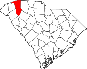
Anderson County is a county located in the U.S. state of South Carolina. As of the 2020 census, its population was 203,718. Its county seat is Anderson. Named for Revolutionary War leader Robert Anderson, the county is located in northwestern South Carolina, along the state line of Georgia. Anderson County is included in the Greenville-Anderson-Greer, SC Metropolitan Statistical Area. Anderson County contains 55,950-acre (22,640 ha) Lake Hartwell, a U.S. Army Corps of Engineers lake with nearly 1,000 miles (1,600 km) of shoreline for residential and recreational use. The area is a growing industrial, commercial and tourist center. It is the home of Anderson University, a private, selective comprehensive university of approximately 4,000 undergraduate and graduate students.

<span class="mw-page-title-main">Anderson, South Carolina</span> City in South Carolina, United States

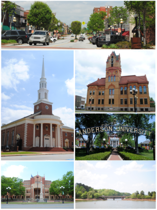
Anderson is a city in and the county seat of Anderson County, South Carolina, United States. The population was 28,106 at the 2020 census, making it the 16th-most populous city in South Carolina. It is one of the principal cities in the Greenville-Anderson-Greer, SC Metropolitan Statistical Area, which had an estimated population of 975,480 in 2023. It is included in the larger Greenville-Spartanburg-Anderson, SC Combined Statistical Area, which had an estimated population of 1,590,636 in 2023. It is just off Interstate 85 and is 120 miles (190 km) from Atlanta and 140 miles (230 km) from Charlotte. Anderson is the smallest of the three primary cities that make up the Upstate region, and is nicknamed the "Electric City" and the "Friendliest City in South Carolina".

<span class="mw-page-title-main">Gaffney, South Carolina</span> City in South Carolina, United States

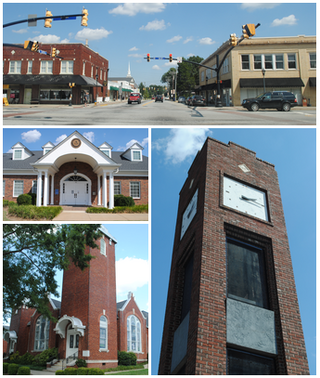
Gaffney is a city in and the seat of Cherokee County, South Carolina, United States, in the Upstate region of South Carolina. Gaffney is known as the "Peach Capital of South Carolina". The population was 12,539 at the 2010 census, with an estimated population of 12,609 in 2019. It is the principal city of the Gaffney, South Carolina, Micropolitan Statistical Area, which includes all of Cherokee County and which is further included in the greater Greenville-Spartanburg-Anderson, South Carolina Combined Statistical Area.

<span class="mw-page-title-main">Greenville, South Carolina</span> City in South Carolina, United States

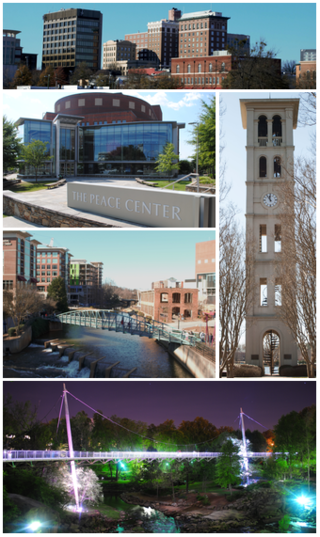
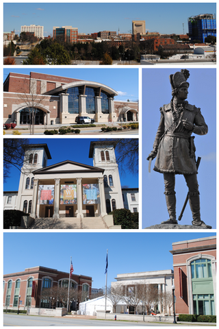
Greenville is a city in and the county seat of Greenville County, South Carolina, United States. With a population of 70,720 at the 2020 census, it is the 6th-most populous city in the state. Greenville is located approximately halfway between Atlanta, Georgia, and Charlotte, North Carolina, along Interstate 85. Its metropolitan area also includes Interstates 185 and 385. Greenville is the anchor city of the Upstate, a combined statistical area with an estimated population of 1,590,636 in 2023. Greenville was the fourth fastest-growing city in the United States between 2015 and 2016, according to the U.S. Census Bureau.

<span class="mw-page-title-main">Simpsonville, South Carolina</span> City in South Carolina, United States

Simpsonville is a city in Greenville County, South Carolina, United States. It is part of the Greenville, SC Metropolitan Statistical Area. The population was 23,354 at the 2020 census, up from 18,238 in the 2010 census. Simpsonville is part of the "Golden Strip", along with Mauldin and Fountain Inn, an area which is noted for having low unemployment due to a diversity of industries including H.B. Fuller, KEMET, Sealed Air and Milliken. It is the 23rd-most populous city in South Carolina.

<span class="mw-page-title-main">Spartanburg, South Carolina</span> City in South Carolina

Spartanburg is a city in and the seat of Spartanburg County, South Carolina, United States. The city had a population of 38,732 as of the 2020 census, making it the 11th-most populous city in the state. For a time, the Office of Management and Budget (OMB) grouped Spartanburg and Union counties together as the Spartanburg, SC Metropolitan Statistical Area, but the OMB now defines the Spartanburg, SC MSA as only Spartanburg County.

<span class="mw-page-title-main">Clemson, South Carolina</span> City in South Carolina, United States

Clemson is a city in Pickens and Anderson counties in the U.S. state of South Carolina. Clemson is home to Clemson University; in 2015, the Princeton Review cited the town of Clemson as ranking #1 in the United States for "town-and-gown" relations with its resident university. The population of the city was 17,681 at the 2020 census.

<span class="mw-page-title-main">Greenville–Spartanburg International Airport</span> Airport in South Carolina, United States

Greenville–Spartanburg International Airport is near Greer, South Carolina, United States, midway between Greenville and Spartanburg, the major cities of the Upstate region. The airport is the third-busiest airport in South Carolina, after Charleston International Airport, and Myrtle Beach International Airport with over 2.56 million passengers in 2023.

<span class="mw-page-title-main">Upstate South Carolina</span> CSA in South Carolina, United States

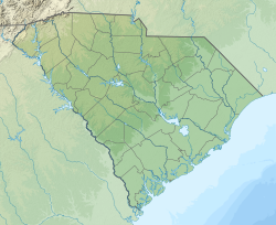
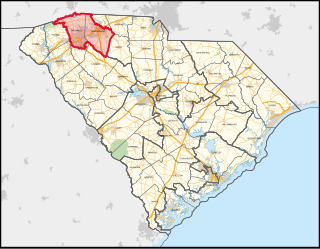
The Upstate, historically known as the Upcountry, is a region of the U.S. state of South Carolina, comprising the northwesternmost area of the state. Although loosely defined among locals, the general definition includes the 10 counties of the commerce-rich I-85 corridor in the northwest corner of South Carolina. This definition coincided with the Greenville-Spartanburg-Anderson, SC Combined Statistical Area, as first defined by the Office of Management and Budget (OMB) in 2015. In 2023, the OMB issued its most updated definition of the CSA that coincides again with the 10-county region.

<span class="mw-page-title-main">Interstate 85 in South Carolina</span> Interstate in South Carolina

Interstate 85 (I-85) in the U.S. state of South Carolina runs northeast–southwest through Upstate South Carolina. Connecting regionally with Atlanta, Georgia, and Charlotte, North Carolina, it became the first Interstate Highway in South Carolina to have its originally planned mileage completed.

<span class="mw-page-title-main">South Carolina's 4th congressional district</span> U.S. House district for South Carolina

South Carolina's 4th congressional district is a congressional district in upstate South Carolina bordering North Carolina. It includes parts of Greenville and Spartanburg counties. The district includes the two major cities of Greenville and Spartanburg.

The Piedmont & Northern Railway was a heavy electric interurban company operating over two disconnected divisions in North and South Carolina. Tracks spanned 128 miles (206 km) total between the two segments, with the northern division running 24 miles (39 km) from Charlotte, to Gastonia, North Carolina, including a three-mile (5 km) spur to Belmont. The southern division main line ran 89 miles (143 km) from Greenwood to Spartanburg, South Carolina, with a 12 mi (19 km) spur to Anderson. Initially the railroad was electrified at 1500 volts DC, however, much of the electrification was abandoned when dieselisation was completed in 1954.

Spartanburg Regional Healthcare System(SRHS) is one of South Carolina's largest healthcare systems. SRHS draws patients primarily from the areas of Spartanburg, Cherokee, Union, and Greenville counties (all located in the Piedmont region of South Carolina) as well as Rutherford and Polk counties (located in western North Carolina). Spartanburg General Hospital was organized under the authority of the South Carolina General Assembly in 1917 and officially became the Spartanburg Regional Health Services District, Inc., a political subdivision of the State of South Carolina, by the charter granted by the secretary of state of South Carolina on May 1, 1995. 

<span class="mw-page-title-main">U.S. Route 29 in South Carolina</span> Highway in South Carolina

U.S. Highway 29 (US 29) is a 110.202-mile (177.353 km) north–south United States Numbered Highway that travels from the Savannah River to Blacksburg, entirely in Upstate South Carolina.

<span class="mw-page-title-main">South Carolina Highway 14</span> State highway in South Carolina

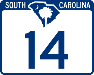
South Carolina Highway 14 is a state highway in the U.S. state of South Carolina. The state highway runs 59.24 miles (95.34 km) from U.S. Route 76 Business in Laurens north to Interstate 26 (I-26) in Landrum. SC 14 connects Laurens and Landrum with Greer, the city between Greenville and Spartanburg where the highway crosses I-85 and US 29. The highway also parallels I-385 through Fountain Inn and Simpsonville, South Carolina in southeastern Greenville County. SC 14 is a part of the National Highway System between I-85 and US 29 in Greer.

<span class="mw-page-title-main">South Carolina Highway 101</span> State highway in South Carolina

South Carolina Highway 101 (SC 101) is a 56.522-mile (90.963 km) state highway in Laurens, Spartanburg, and Greenville counties in the U.S. state of South Carolina. Its southern terminus is at an intersection with U.S. Route 76 (US 76) in Hickory Tavern, and its northern terminus is at an intersection with SC 11 near Landrum.

Gibbs Cancer Center & Research Institute is a cancer treatment and research facility in Upstate South Carolina. Gibbs Cancer Center is associated with the NCI Community Cancer Centers Program and the Medical University of South Carolina. Gibbs has several locations across the upstate of South Carolina, including Comprehensive Cancer Centers at both Spartanburg Medical Center and Pelham Medical Center. Additional infusion facilities are located in Gaffney, Union, Mary Black and North Grove.

References

  1. "History of Greer". www.cityofgreer.org. Retrieved December 7, 2022.
  2. 1 2 "ArcGIS REST Services Directory". United States Census Bureau. Retrieved October 15, 2022.
  3. 1 2 U.S. Geological Survey Geographic Names Information System: Greer, South Carolina
  4. 1 2 "Census Population API". United States Census Bureau. Retrieved October 15, 2022.
  5. 1 2 "U.S. Census website". United States Census Bureau . Retrieved January 31, 2008.
  6. 1 2 "QuickFacts: Greer city, South Carolina". United States Census Bureau. Retrieved May 16, 2024.
  7. "OMB Bulletin No. 23-01: Revised Delineations of Metropolitan Statistical Areas, Micropolitan Statistical Areas, and Combined Statistical Areas, and Guidance on Uses of the Delineations of These Areas" (PDF). United States Office of Management and Budget . July 21, 2023. Retrieved August 10, 2023.
  8. 1 2 3 "History of Greer". www.cityofgreer.org. Retrieved November 6, 2022.
  9. 1 2 "Greer". South Carolina Encyclopedia. Retrieved November 6, 2022.
  10. Project, SC Picture (November 16, 2008). "Greer Station". SC Picture Project. Retrieved November 6, 2022.
  11. "Greer Station". www.cityofgreer.org. Retrieved November 6, 2022.
  12. "South Carolina Railroads - Piedmont & Northern Railway". www.carolana.com. Retrieved November 6, 2022.
  13. "Greer Post Office" . Retrieved December 1, 2013.
  14. "Home". Greer Heritage Museum. Retrieved November 6, 2022.
  15. The Greer Community History Archived October 6, 2011, at the Wayback Machine
  16. "QuickFacts Greer city, South Carolina; United States". American Factfinder. U.S. Census Bureau. Retrieved January 13, 2022.
  17. "Explore Census Data". data.census.gov. Retrieved December 10, 2021.
  18. US Department of Commerce, NOAA. "Greenville-Spartanburg, SC". www.weather.gov. Retrieved February 9, 2024.
  19. "Locations & Hours". Greenville County Library System. Retrieved June 8, 2019.
  20. "National Register Information System". National Register of Historic Places . National Park Service. July 9, 2010.
  21. National Register listing. National Park Service.[ dead link ]
  22. "Greer City Stadium". www.cityofgreer.org. Archived from the original on July 19, 2011.
  23. Fair, Jim (May 9, 2012). "Cannon Centre keeps history and location intact". GreerToday.com. Retrieved February 9, 2024.
  24. "Cannon Centre". www.visitgreenvillesc.com. Retrieved February 9, 2024.
  25. "Mayor". www.cityofgreer.org. Retrieved February 9, 2024.
  26. "Greer City Park". www.visitgreenvillesc.com. Retrieved February 9, 2024.
  27. "Pelham Medical Center - Spartanburg Regional Healthcare System". www.spartanburgregional.com. Retrieved January 17, 2019.
  28. "Gibbs Cancer Center & Research Institute – Pelham". www.spartanburgregional.com. Retrieved January 17, 2019.
  29. "Radiation Oncology at Gibbs Cancer Center - Spartanburg Regional Healthcare System". www.spartanburgregional.com. Retrieved January 17, 2019.
  30. "Greer Memorial Hospital". Prisma Health - Upstate. Retrieved January 17, 2019.
  31. "Greenville-Spartanburg International Airport Information". Airport Hotel Guide.
  32. "Passenger Airlines". GSP International Airport.
  33. "Work Begins on New South Carolina Inland Port". Global Trade. Archived from the original on February 21, 2014. Retrieved February 11, 2014.
  34. "Greer, South Carolina". City-Data.