Allendale County, South Carolina

Last updated

Allendale County
Allendale County Courthouse.jpg
Allendale County Seal.jpg
Map of South Carolina highlighting Allendale County.svg
Location within the U.S. state of South Carolina
South Carolina in United States.svg
South Carolina's location within the U.S.
Coordinates: 32°59′N81°22′W / 32.98°N 81.36°W / 32.98; -81.36
CountryFlag of the United States.svg United States
StateFlag of South Carolina.svg  South Carolina
Founded1919
Named for Paul H. Allen [1]
Seat Allendale
Largest communityAllendale
Area
  Total412.42 sq mi (1,068.2 km2)
  Land408.10 sq mi (1,057.0 km2)
  Water4.32 sq mi (11.2 km2)  1.05%
Population
 (2020)
  Total8,039
  Estimate 
(2023)
7,369
  Density19.70/sq mi (7.61/km2)
Time zone UTC−5 (Eastern)
  Summer (DST) UTC−4 (EDT)
Congressional district 6th
Website www.allendalecounty.com

Allendale County is a county located in the U.S. state of South Carolina. As of the 2020 census, the population was 8,039, [2] making it the least populous county in South Carolina. Its county seat is Allendale. [3]

Contents

History

Allendale County was formed in 1919 from southwestern portions of Barnwell County, along the Savannah River, and part of Hampton County, just to its south. It is the location of the Topper Site, an archeological excavation providing possible evidence of a pre-Clovis culture dating back 50,000 years. The site is near a source of chert on private land in Martin owned by Clariant Corporation, a Swiss chemical company with a plant there. The site, named after John Topper, a nt who discovered it, has been under excavation by archeologists from the University of South Carolina for about one month a year since 1999, after an initial exploratory dig in the mid-1980s.

Allendale County was born out of a desire for convenience. Having a new county circumvented the need to travel to the courthouse in Barnwell or Hampton. The original Allendale County Courthouse burned down in May 1998, with reconstruction begun in August 2002. [4] [5] During the Civil Rights movement, the Courthouse almost became a site for a sit-in protest after African-American citizens charged officials with deliberately delaying the voter registration of black residents. [6] [7] [8]

Geography

Allendale County, South Carolina
Interactive map of Allendale County

According to the U.S. Census Bureau, the county has a total area of 412.42 square miles (1,068.2 km2), of which 408.10 square miles (1,057.0 km2) is land and 4.32 square miles (11.2 km2) (1.05%) is water. [9] The Savannah River forms the county's western border with Georgia.

Allendale is 62 miles (100 km) from Augusta, Georgia; 73 miles (117 km) from Savannah, Georgia; 87 miles (140 km) from Columbia; and 90 miles (140 km) from Charleston. Before interstate highways were built, Allendale had several motels, primarily serving travelers in-between Northeastern states and Florida. Traffic that formerly traveled US 301 through Allendale now uses Interstate 95.

Major water bodies

Adjacent counties

Major highways

Major infrastructure

Demographics

Historical population
CensusPop.Note
1920 16,098
1930 13,294−17.4%
1940 13,040−1.9%
1950 11,773−9.7%
1960 11,362−3.5%
1970 9,692−14.7%
1980 10,70010.4%
1990 11,7229.6%
2000 11,211−4.4%
2010 10,419−7.1%
2020 8,039−22.8%
2023 (est.)7,369 [2] −8.3%
U.S. Decennial Census [10]
1790–1960 [11] 1900–1990 [12]
1990–2000 [13] 2010 [14] 2020 [2]

2020 census

Allendale County racial composition [15]
RaceNum.Perc.
White (non-Hispanic)1,98524.69%
Black or African American (non-Hispanic)5,64670.23%
Native American 450.56%
Asian 170.21%
Pacific Islander 10.01%
Other/Mixed 1511.88%
Hispanic or Latino 1942.41%

As of the 2020 census, there were 8,039 people, 3,281 households, and 1,389 families residing in the county. The median age was 51.4 for women and 44.5 for men. About 23.7% of households had children living with them. Renters make up 35.6% of households. [16] Available housing was more than the number of households, totaling 4,040 housing units, [17] all of which are classified as rural. [18] The median household size was 2 (with a mean of 2.2). [19]

2020 age and sex demographics for Allendale County, visualized as a population pyramid Allendale County, South Carolina Population Pyramid 2020 Census.png
2020 age and sex demographics for Allendale County, visualized as a population pyramid

2010 census

At the 2010 census, there were 10,419 people, 3,706 households, and 2,333 families living in the county. [20] The population density was 25.5 inhabitants per square mile (9.8/km2). There were 4,486 housing units at an average density of 11.0 per square mile (4.2/km2). [21] The racial makeup of the county was 73.6% black or African American, 23.7% white, 0.4% Asian, 0.2% American Indian, 1.3% from other races, and 0.8% from two or more races. Those of Hispanic or Latino origin made up 2.3% of the population. [20] In terms of ancestry, and 5.6% were American. [22]

Of the 3,706 households, 32.2% had children under the age of 18 living with them, 31.5% were married couples living together, 26.9% had a female householder with no husband present, 37.0% were non-families, and 33.7% of households were made up of individuals. The average household size was 2.45 and the average family size was 3.14. The median age was 38.8 years. [20]

The median household income was $20,081 and the median family income was $25,146. Males had a median income of $30,440 versus $28,889 for females. The per capita income for the county was $14,190. About 35.7% of families and 42.4% of the population were below the poverty line, including 53.8% of those under age 18 and 27.4% of those age 65 or over. [23]

2000 census

At the 2000 census, there were 11,211 people, 3,915 households, and 2,615 families living in the county. The population density was 28 people per square mile (11 people/km2). There were 4,568 housing units at an average density of 11 per square mile (4.2/km2). The racial makeup of the county was 71.0 percent Black or African American, 27.37 percent White, 0.12 percent Asian, 0.09 percent Native American, 0.06 percent Pacific Islander, 0.85 percent from other races, and 0.51 percent from two or more races. 1.61 percent of the population were Hispanic or Latino of any race. [24] Of the 3,915 households, 30.3 percent had children under the age of 18 living with them, 35.8 percent were married couples living together, 25.8 percent had a female householder with no husband present, and 33.2 percent were non-families. 30.0 percent of all households were one person and 12.3 percent had someone living alone who was 65 or older. The average household size was 2.56 and the average family size was 3.21.

The age distribution was 26.6 percent under the age of 18, 9.8 percent from 18 to 24, 28.2 percent from 25 to 44, 22.8 percent from 45 to 64, and 12.7 percent who were 65 or older. The median age was 35 years. For every 100 females there were 108.6 males. For every 100 females age 18 and over, there were 107.5 males.

The median household income was $20,898 and the median family income was $27,348. Males had a median income of $25,930 versus $20,318 for females. The per capita income for the county was $11,293. About 28.4 percent of families and 34.5 percent of the population were below the poverty line, including 48.1 percent of those under age 18 and 26.00 percent of those age 65 or over. [25]

Government and politics

County Council

Allendale County has a five-member council elected from single-member districts. The council has a single chairman. Council members serve four-year terms. [26]

Allendale County Council Elected Members [27]
2020
District 1Theresa Taylor
District 2James White, Jr.
District 3Willa Jennings
District 4Matthew Connelly, Chair
District 5William Robinson, Vice Chair

Other County Officials

Allendale County Elected Officials [28]
2020
SheriffJames Freeman [29]
TreasurerAlice Kirkland
Clerk of CourtElaine Sabb (since 2007) [30]
CorornerRenique Riley
Probate JudgeD. Keith Smith

S.C. Senate

Leading up to the 2020 Census Redistricting, Allendale County was divided between Senate districts 40 (the eastern half) and 45 (the western half). Senate District 40 has been represented by Democrat and Minority Leader Brad Hutto since 1996. [31] Democrat Margie Bright Matthews has represented District 45 since 2015, after she was elected to the position to fulfill the unexpired term of Clementa C. Pinckney. [32]

Following the redistricting, which will be used in the 2024 United States elections despite legal disputes over racial and political gerrymandering, Allendale County is solely covered by state Senate District 40. [33]

Senators representing Allendale County in the South Carolina Senate
NameYears ActivePartyDistrictOther Counties
(John) Henry Johnson [34] 1920–1923 [35] [36] At-large
Robinson Plato Searson, Jr.1923–1926 [36] [37]

1931–1938 [38] [39]

At-large
George Dunbar Kirkland1927–1930 [40] [41] At-large
James Martin Thomas1939–1942 [42] [43]

1947–1950 [44] [45]

At-large
William Edwin Myrick1943–1946 [46] [47]

1951–1962 [48] [49]

At-large
Audrey Patterson Williams1963–1966 [50] [51] At-large
Edgar Allan Brown 1967–1972 [52] [53] Democratic18 (1967–1968)

12 (1969–1972)

Bamberg, Barnwell
James Pershing Harrelson1973–1976 [54] [55] Democratic15Beaufort, Colleton, Hampton, Jasper
James Madison Wadell, Jr.1973–1984 [54] [56] Democratic15Beaufort, Colleton, Hampton, Jasper
William Tindall Howell1977–1979 [57] [58] Democratic15Beaufort, Colleton, Hampton, Jasper
Peden B. McLeod 1980–1990 [59] [60] Democratic15 (1980–1984)

45 (1985–1990)

Beaufort,

Charleston (1985–1990), Colleton, Hampton, Jasper

John W. Matthews Jr. 1985–2002 [61] [62] Democratic39Bamberg, Barnwell, Calhoun, Dorchester, Orangeburg
McKinley Washington Jr. 1990–1992 [60] [63] Democratic45Beaufort, Charleston, Colleton, Hampton, Jasper
Bradley Hutto 2003–present [64] Democratic40 (2003–2012)

40 (2013–present)

Bamberg (2013–present), Barnwell, Colleton (2013–present), Hampton, Orangeburg
Clementa Pinckney 2003–2015 [64] [65] Democratic45Beaufort, Charleston, Colleton, Hampton, Jasper
Margie Bright Matthews 2015–2024 [65] Democratic45Beaufort, Charleston, Colleton, Hampton, Jasper

U.S. Presidential elections

Allendale County has been consistently Democratic in Presidential voting since 1976 and was among the few counties to be carried by Walter Mondale in 1984. [66] In the 2008 U.S. presidential election Barack Obama received 75.3 percent of the county's vote. [67] In the 2012 U.S. presidential election Barack Obama received 79.2 percent of the county's vote. In the 2020 U.S. presidential election, Joe Biden received 75.7% of the vote. [68]

United States presidential election results for Allendale County, South Carolina [69]
Year Republican Democratic Third party
No.%No.%No.%
2020 83523.24%2,71875.65%401.11%
2016 78921.97%2,73576.14%681.89%
2012 83820.13%3,29779.20%280.67%
2008 94723.53%3,02975.27%481.19%
2004 98527.43%2,56571.43%411.14%
2000 96728.95%2,33870.00%351.05%
1996 94128.75%2,22267.89%1103.36%
1992 1,04930.36%2,15962.49%2477.15%
1988 1,29541.59%1,79657.68%230.74%
1984 1,57041.66%2,17057.57%290.77%
1980 1,18229.62%2,77869.62%300.75%
1976 1,06428.69%2,63471.02%110.30%
1972 1,74155.34%1,38644.06%190.60%
1968 99729.72%1,53845.84%82024.44%
1964 1,74069.27%77230.73%00.00%
1960 88860.37%58339.63%00.00%
1956 26219.89%38028.85%67551.25%
1952 75163.06%44036.94%00.00%
1948 141.26%554.95%1,04193.78%
1944 81.11%67894.43%324.46%
1940 303.21%90596.79%00.00%
1936 30.24%1,23699.76%00.00%
1932 100.89%1,10899.11%00.00%
1928 242.86%81697.14%00.00%
1924 143.02%45096.98%00.00%
1920 112.44%44097.56%00.00%

Economy

Allendale is primarily an agricultural rural county. Its primary products are cotton, soybeans, watermelon and cantaloupe. Timbering is also important, primarily for paper pulp.

In 2022, Allendale's GDP was $317.5 million (approx. $39,491 per capita). [70] In chained 2017 dollars, its real GDP was $240.4 million (approx. $29,902 per capita). [71] From 2021 through 2024, its unemployment rate has fluctuated between 4-8%. [72]

As of April 2024, some of the largeest employers in the county include Atlantic Power Corporation, AZ Electronic Materials, Georgia-Pacific, South Carolina Department of Corrections (SCDC), and the University of South Carolina. [73]

Employment and Wage Statistics by Industry in Allendale County, South Carolina [73]
IndustryEmployment CountsEmployment Percentage (%)Average Annual Wage ($)
Accommodation and Food Services462.015,808
Administrative and Support and Waste Management and Remediation Services130.628,600
Agriculture, Forestry, Fishing and Hunting1175.046,124
Construction200.930,472
Educational Services28012.050,336
Finance and Insurance301.338,740
Health Care and Social Assistance36015.443,264
Manufacturing78233.585,228
Other Services (except Public Administration)40.218,200
Professional, Scientific, and Technical Services321.451,064
Public Administration38216.449,868
Retail Trade1406.019,708
Transportation and Warehousing582.553,300
Wholesale Trade682.958,708
Total2,332100.0%57,969

Education

Colleges and universities

The county is also the site of WEBA, Channel 14, a broadcast outlet of the South Carolina Educational Television Network. Ranking 45th in population among the state's 46 counties, it is the smallest county to have either a state-supported college or an ETV station.

High schools

Allendale County School District includes one high school: Allendale-Fairfax High School. The former C. V. Bing High School served African-American students during the time of segregation.

Media

Allendale County is a news desert. The last local news publications, The Citizen-Leader and The Allendale Sun, stopped printing in 2014 and 2015, respectively. [74]

Communities

Towns

Unincorporated communities

See also

Related Research Articles

<span class="mw-page-title-main">Orangeburg County, South Carolina</span> County in South Carolina, United States

Orangeburg County is a county located in the U.S. state of South Carolina. As of the 2020 census, the population was 84,223. Its county seat is Orangeburg. The county was created in 1769.

<span class="mw-page-title-main">Newberry County, South Carolina</span> County in South Carolina, United States

Newberry County is a county located in the U.S. state of South Carolina. As of the 2020 census, its population was 37,719. Its county seat is Newberry. The name is of unknown origin, although one theory suggests that it was named by Quaker settlers in honor of their home of Newberry, a suburb of London in the United Kingdom.

<span class="mw-page-title-main">Marlboro County, South Carolina</span> County in South Carolina, United States

Marlboro County is a county located in the Pee Dee region on the northern border of the U.S. state of South Carolina. As of the 2020 census, its population was 26,667. Its county seat is Bennettsville. The Great Pee Dee River runs through it.

<span class="mw-page-title-main">Lexington County, South Carolina</span> County in South Carolina, United States

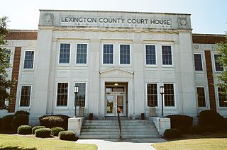
Lexington County is a county located in the U.S. state of South Carolina. As of the 2020 census, the population was 293,991. Its county seat and largest community is Lexington. The county was chartered in 1785 and was named in commemoration of Lexington, Massachusetts, the site of the Battle of Lexington in the American Revolutionary War. Lexington County is the sixth-most populous county in South Carolina by population and is part of the Columbia, SC Metropolitan Statistical Area. It is located in the Midlands region of South Carolina.

<span class="mw-page-title-main">Lee County, South Carolina</span> County in South Carolina, United States

Lee County is a county located in the U.S. state of South Carolina. As of the 2020 census, its population was 16,531, making it the fifth-least populous county in South Carolina. Its county seat is Bishopville.

<span class="mw-page-title-main">Hampton County, South Carolina</span> County in South Carolina, United States

Hampton County is a rural county located in the U.S. state of South Carolina. As of the 2020 census, the population was 18,561. Its county seat is Hampton. It was named for Confederate Civil War general Wade Hampton, who in the late 1870s, with the ending of Reconstruction, was elected as governor of South Carolina.

<span class="mw-page-title-main">Greenwood County, South Carolina</span> County in South Carolina, United States

Greenwood County is a county located in the U.S. state of South Carolina. As of the 2020 census, its population was 69,351. Its county seat is Greenwood.

<span class="mw-page-title-main">Georgetown County, South Carolina</span> County in South Carolina, United States

Georgetown County is a county located in the U.S. state of South Carolina. As of the 2020 census, the population was 63,404. Its county seat is Georgetown. The county was founded in 1769. It is named for George III of the United Kingdom.

<span class="mw-page-title-main">Fairfield County, South Carolina</span> County in South Carolina, United States

Fairfield County is a county located in the U.S. state of South Carolina. As of the 2020 census, its population was 20,948. Its county seat is Winnsboro.

<span class="mw-page-title-main">Edgefield County, South Carolina</span> County in South Carolina, United States

Edgefield County is a county located on the western border of the U.S. state of South Carolina. As of the 2020 census, its population was 25,657. Its county seat and largest community is Edgefield. The county was established on March 12, 1785.

<span class="mw-page-title-main">Colleton County, South Carolina</span> County in South Carolina, United States

Colleton County is in the Lowcountry region of the U.S. state of South Carolina. As of the 2020 census, the population was 38,604. Its county seat is Walterboro. The county is named after Sir John Colleton, 1st Baronet, one of the eight Lords Proprietor of the Province of Carolina. After two previous incarnations, the current Colleton County was created in 1800.

<span class="mw-page-title-main">Chester County, South Carolina</span> County in South Carolina, United States

Chester County is a county located in the U.S. state of South Carolina. As of the 2020 census, its population was 32,294. Its county seat is Chester.

<span class="mw-page-title-main">Charleston County, South Carolina</span> County in South Carolina, United States

Charleston County is located in the U.S. state of South Carolina along the Atlantic coast. As of the 2020 census, the population was 408,235, making it the third-most populous county in South Carolina. Its county seat is Charleston. It is also the largest county in the state by total area, although Horry County has a larger land area. The county was created in 1800 by an act of the South Carolina State Legislature.

<span class="mw-page-title-main">Barnwell County, South Carolina</span> County in South Carolina, United States

Barnwell County is a county in the U.S. state of South Carolina. As of the 2020 census, its population was 20,589. It is located in the Central Savannah River Area. Its county seat is Barnwell.

<span class="mw-page-title-main">Bamberg County, South Carolina</span> County in South Carolina, United States

Bamberg County is a county located in the southwestern portion of U.S. state of South Carolina. As of the 2020 census, the population was 13,311, making the rural county the fourth-least populous of any in South Carolina. Its county seat is Bamberg.

<span class="mw-page-title-main">Anderson County, South Carolina</span> County in South Carolina, United States

Anderson County is a county located in the U.S. state of South Carolina. As of the 2020 census, its population was 203,718. Its county seat is Anderson. Named for Revolutionary War leader Robert Anderson, the county is located in northwestern South Carolina, along the state line of Georgia. Anderson County is included in the Greenville-Anderson-Greer, SC Metropolitan Statistical Area. Anderson County contains 55,950-acre (22,640 ha) Lake Hartwell, a U.S. Army Corps of Engineers lake with nearly 1,000 miles (1,600 km) of shoreline for residential and recreational use. The area is a growing industrial, commercial and tourist center. It is the home of Anderson University, a private, selective comprehensive university of approximately 4,000 undergraduate and graduate students.

<span class="mw-page-title-main">Aiken County, South Carolina</span> County in South Carolina, United States

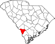
Aiken County is a county in the U.S. state of South Carolina. As of the 2020 census, its population was 168,808. Its county seat and largest community is Aiken. Aiken County is a part of the Augusta-Richmond County, GA-SC Metropolitan Statistical Area. It is mostly in the Sandhills region, with the northern parts reaching in the Piedmont and southern parts reaching into the Coastal Plain.

<span class="mw-page-title-main">Rutherfordton, North Carolina</span> Town in North Carolina, United States

Rutherfordton is a town and the county seat of Rutherford County, North Carolina, United States. The population was 4,213 at the 2010 census.

<span class="mw-page-title-main">Allendale, South Carolina</span> Town in South Carolina, United States

Allendale is a town in and the county seat of Allendale County, South Carolina, United States. The population was 3,482 at the 2010 census, a decline from 4,052 in 2000.

Sycamore is a town in Allendale County, South Carolina, United States. The population was 180 as of the 2010 census. On April 5, 2022, the town was hit by an EF3 tornado, although it had weakened to EF1 strength by the time it moved through town and only minor damage occurred. One person was injured by this tornado south of Allendale, South Carolina.

References

  1. Federal Writers' Project (1941). Palmetto Place Names. Sloane Printing Co. p. 11.
  2. 1 2 3 "QuickFacts: Allendale County, South Carolina". United States Census Bureau. Retrieved March 22, 2024.
  3. "Find a County". National Association of Counties. Archived from the original on May 31, 2011. Retrieved June 7, 2011.
  4. "Allendale County". South Carolina Encyclopedia. Retrieved May 6, 2024.
  5. "Allendale County Courthouse, Allendale County (292 Barnwell Hwy., Allendale)". National Register Properties in South Carolina. South Carolina Department of Archives and History. August 1, 2007. Retrieved May 6, 2024.
  6. The Associated Press (July 28, 1965). "38 Arrested: Seize Civil Rights Pickets in Allendale Sit-in Protests". The Michigan Daily. p. 3. Retrieved May 6, 2024.
  7. AP (August 3, 1965). "37 Arrested As Police Break Up Allendale Sit-In". Herald-Journal. p. 1. Retrieved May 6, 2024.
  8. AP (August 4, 1965). "Protest Segregation: Angry Neighbors of Chicago Mayor Pelt Demonstrators". Prescott Evening Courier. p. 3. Retrieved May 6, 2024.
  9. "2020 County Gazetteer Files – South Carolina". United States Census Bureau. August 23, 2022. Retrieved September 10, 2023.
  10. "U.S. Decennial Census". United States Census Bureau. Retrieved March 15, 2015.
  11. "Historical Census Browser". University of Virginia Library. Retrieved March 15, 2015.
  12. Forstall, Richard L., ed. (March 27, 1995). "Population of Counties by Decennial Census: 1900 to 1990". United States Census Bureau. Retrieved March 15, 2015.
  13. "Census 2000 PHC-T-4. Ranking Tables for Counties: 1990 and 2000" (PDF). United States Census Bureau. April 2, 2001. Archived (PDF) from the original on October 9, 2022. Retrieved March 15, 2015.
  14. "State & County QuickFacts". United States Census Bureau. Archived from the original on June 6, 2011. Retrieved November 22, 2013.
  15. "Explore Census Data". data.census.gov. Retrieved December 14, 2021.
  16. 1 2 United States Census Bureau. "PROFILE OF GENERAL POPULATION AND HOUSING CHARACTERISTICS". Census Bureau. Retrieved May 8, 2024.
  17. U.S. Census Bureau (2020). "HOUSING UNITS". data.census.gov. U.S. Census Bureau. Retrieved May 9, 2024.
  18. U.S. Census Bureau. "URBAN AND RURAL." Decennial Census, DEC Demographic and Housing Characteristics, Table H2, 2020, https://data.census.gov/table/DECENNIALDHC2020.H2?g=050XX00US45005&y=2020&d=DEC Demographic and Housing Characteristics. Accessed on May 8, 2024.
  19. U.S. Census Bureau. "HISPANIC OR LATINO, AND NOT HISPANIC OR LATINO BY RACE." Decennial Census, DEC Redistricting Data (PL 94-171), Table P2, 2020, https://data.census.gov/table/DECENNIALPL2020.P2?g=050XX00US45005. Accessed on May 8, 2024.
  20. 1 2 3 "DP-1 Profile of General Population and Housing Characteristics: 2010 Demographic Profile Data". United States Census Bureau. Archived from the original on February 13, 2020. Retrieved March 9, 2016.
  21. "Population, Housing Units, Area, and Density: 2010 - County". United States Census Bureau. Archived from the original on February 13, 2020. Retrieved March 9, 2016.
  22. "DP02 SELECTED SOCIAL CHARACTERISTICS IN THE UNITED STATES – 2006-2010 American Community Survey 5-Year Estimates". United States Census Bureau. Archived from the original on February 13, 2020. Retrieved March 9, 2016.
  23. "DP03 SELECTED ECONOMIC CHARACTERISTICS – 2006-2010 American Community Survey 5-Year Estimates". United States Census Bureau. Archived from the original on February 13, 2020. Retrieved March 9, 2016.
  24. "U.S. Census website". United States Census Bureau . Retrieved May 14, 2011.
  25. US Census Bureau Demographics Data
  26. "Welcome to Allendale County, SC". www.allendalecounty.com. Retrieved May 6, 2024.
  27. "Welcome to Allendale County, SC". www.allendalecounty.com. Retrieved May 6, 2024.
  28. "Welcome to Allendale County, SC". www.allendalecounty.com. Retrieved May 6, 2024.
  29. "Allendale County - South Carolina Sheriffs' Association". www.sheriffsc.org. Retrieved May 6, 2024.
  30. "Clerk of Court". www.sccourts.org. Retrieved May 6, 2024.
  31. "South Carolina Legislature Online - Member Biography". www.scstatehouse.gov. Retrieved May 9, 2024.
  32. "South Carolina Legislature Online - Member Biography". www.scstatehouse.gov. Retrieved May 9, 2024.
  33. "2020 Statewide Senate Districts" (PDF). rfa.sc.gov. South Carolina Revenue and Fiscal Affairs Office. April 1, 2022. Retrieved May 9, 2024.{{cite web}}: CS1 maint: date and year (link)
  34. Snowden, Yates; Cutler, Harry Gardner (1920). History of South Carolina. Lewis Publishing Company.
  35. "South Carolina During the 1900s - The 73rd General Assembly (1919-1920)". www.carolana.com. Retrieved May 15, 2024.
  36. 1 2 "South Carolina During the 1900s - The 75th General Assembly (1923-1924)". www.carolana.com. Retrieved May 15, 2024.
  37. "South Carolina During the 1900s - The 76th General Assembly (1925-1926)". www.carolana.com. Retrieved May 15, 2024.
  38. "South Carolina During the 1900s - The 79th General Assembly (1931-1932)". www.carolana.com. Retrieved May 15, 2024.
  39. "South Carolina During the 1900s - The 82nd General Assembly (1937-1938)". www.carolana.com. Retrieved May 15, 2024.
  40. "South Carolina During the 1900s - The 77th General Assembly (1927-1928)". www.carolana.com. Retrieved May 15, 2024.
  41. "South Carolina During the 1900s - The 78th General Assembly (1929-1930)". www.carolana.com. Retrieved May 15, 2024.
  42. "South Carolina During the 1900s - The 83rd General Assembly (1939-1940)". www.carolana.com. Retrieved May 15, 2024.
  43. "South Carolina During the 1900s - The 84th General Assembly (1941-1942)". www.carolana.com. Retrieved May 15, 2024.
  44. "South Carolina During the 1900s - The 87th General Assembly (1947-1948)". www.carolana.com. Retrieved May 15, 2024.
  45. "South Carolina During the 1900s - The 88th General Assembly (1949-1950)". www.carolana.com. Retrieved May 15, 2024.
  46. "South Carolina During the 1900s - The 85th General Assembly (1943-1944)". www.carolana.com. Retrieved May 15, 2024.
  47. "South Carolina During the 1900s - The 86th General Assembly (1945-1946)". www.carolana.com. Retrieved May 15, 2024.
  48. "South Carolina During the 1900s - The 89th General Assembly (1951-1952)". www.carolana.com. Retrieved May 15, 2024.
  49. "South Carolina During the 1900s - The 94th General Assembly (1961-1962)". www.carolana.com. Retrieved May 15, 2024.
  50. "South Carolina During the 1900s - The 95th General Assembly (1963-1964)". www.carolana.com. Retrieved May 15, 2024.
  51. "South Carolina During the 1900s - The 96th General Assembly (1965-1966)". www.carolana.com. Retrieved May 15, 2024.
  52. "South Carolina During the 1900s - The 97th General Assembly (1967-1968)". www.carolana.com. Retrieved May 15, 2024.
  53. "South Carolina During the 1900s - The 99th General Assembly (1971-1972)". www.carolana.com. Retrieved May 15, 2024.
  54. 1 2 "South Carolina During the 1900s - The 100th General Assembly (1972-1974)". www.carolana.com. Retrieved May 15, 2024.
  55. "South Carolina During the 1900s - The 101st General Assembly (1975-1976)". www.carolana.com. Retrieved May 15, 2024.
  56. "South Carolina During the 1900s - The 105th General Assembly (1983-1984)". www.carolana.com. Retrieved May 15, 2024.
  57. "South Carolina During the 1900s - The 102nd General Assembly (1977-1978)". www.carolana.com. Retrieved May 15, 2024.
  58. "South Carolina During the 1900s - The 103rd General Assembly (1979-1980)". www.carolana.com. Retrieved May 15, 2024.
  59. "South Carolina During the 1900s - The 103rd General Assembly (1979-1980)". www.carolana.com. Retrieved May 15, 2024.
  60. 1 2 "South Carolina During the 1900s - The 109th General Assembly (1991-1992)". www.carolana.com. Retrieved May 15, 2024.
  61. "South Carolina During the 1900s - The 106th General Assembly (1985-1986)". www.carolana.com. Retrieved May 15, 2024.
  62. "South Carolina During the 2000s - The 114th General Assembly (2001-2002)". www.carolana.com. Retrieved May 15, 2024.
  63. "South Carolina During the 1900s - The 109th General Assembly (1991-1992)". www.carolana.com. Retrieved May 15, 2024.
  64. 1 2 "South Carolina During the 2000s - The 115th General Assembly (2003-2004)". www.carolana.com. Retrieved May 15, 2024.
  65. 1 2 "South Carolina During the 2000s - The 121st General Assembly (2015-2016)". www.carolana.com. Retrieved May 15, 2024.
  66. Leip, Dave. "1984 Presidential General Election Results - South Carolina". uselectionatlas.org. Retrieved October 15, 2023.
  67. "Election Results 2008". The New York Times. December 9, 2008. Retrieved October 15, 2023.
  68. "Presidential Results". CNN Politics. May 5, 2021. Retrieved October 15, 2023.
  69. Leip, David. "Dave Leip's Atlas of U.S. Presidential Elections". uselectionatlas.org. Retrieved March 13, 2018.
  70. U.S. Bureau of Economic Analysis (January 1, 2001). "Gross Domestic Product: All Industries in Allendale County, SC". FRED, Federal Reserve Bank of St. Louis. Retrieved April 28, 2024.
  71. U.S. Bureau of Economic Analysis (January 1, 2001). "Real Gross Domestic Product: All Industries in Allendale County, SC". FRED, Federal Reserve Bank of St. Louis. Retrieved April 28, 2024.
  72. U.S. Bureau of Labor Statistics (January 1, 1990). "Unemployment Rate in Allendale County, SC". FRED, Federal Reserve Bank of St. Louis. Retrieved April 28, 2024.
  73. 1 2 "Allendale County" (PDF). Community Profiles. Columbia, SC: S.C. Department of Employment & Workforce; Business Intelligence Department: 6, 8. April 19, 2024.
  74. Hawes, Jennifer Berry (August 24, 2021). "Uncovered: SC citizen watchdogs fill voids as news deserts spread across the country". The Sumter Item. Retrieved May 14, 2024.