McCormick, South Carolina

Last updated

McCormick, South Carolina
Town
McCormick SC.jpg
Downtown McCormick
McCormick, SC Town Seal.svg
McCormick County South Carolina incorporated and unincorporated areas McCormick highlighted.svg
Location in McCormick County and the state of South Carolina.
Coordinates: 33°54′49″N82°17′21″W / 33.91361°N 82.28917°W / 33.91361; -82.28917
CountryUnited States
StateSouth Carolina
County McCormick
Area
[1]
  Total4.05 sq mi (10.49 km2)
  Land4.05 sq mi (10.49 km2)
  Water0.00 sq mi (0.00 km2)
Elevation
535 ft (163 m)
Population
 (2020) [2]
  Total2,232
  Density550.84/sq mi (212.70/km2)
Time zone UTC−5 (Eastern (EST))
  Summer (DST) UTC−4 (EDT)
ZIP codes
29835, 29899
Area code 864
FIPS code 45-43720 [3]
GNIS feature ID1246583 [4]
Website www.townofmccormicksc.org

McCormick is a town in McCormick County, South Carolina, United States. The population was 2,232 at the 2020 census. [5] It is the county seat of McCormick County. The town of McCormick is named for inventor Cyrus McCormick.

Contents

History

The Dorn Gold Mine, Dorn's Flour and Grist Mill, Joseph Jennings Dorn House, Eden Hall, Farmer's Bank, John Albert Gibert M.D. House, Otway Henderson House, Hotel Keturah, McCormick County Courthouse, McCormick Train Station, and M.L.B. Sturkey House are listed on the National Register of Historic Places. [6]

Geography

McCormick is located at 33°54′49″N82°17′21″W / 33.91361°N 82.28917°W / 33.91361; -82.28917 (33.913565, -82.289154). [7]

According to the United States Census Bureau, the town has a total area of 3.8 square miles (9.8 km2), all land.

Demographics

Historical population
CensusPop.Note
1900 237
1910 613158.6%
1920 1,284109.5%
1930 1,3041.6%
1940 1,45611.7%
1950 1,74419.8%
1960 1,99814.6%
1970 1,864−6.7%
1980 1,725−7.5%
1990 1,659−3.8%
2000 1,489−10.2%
2010 2,78386.9%
2020 2,232−19.8%
U.S. Decennial Census [8] [2]

2020 census

McCormick racial composition [9]
RaceNum.Perc.
White (non-Hispanic)66429.75%
Black or African American (non-Hispanic)1,46765.73%
Native American 40.18%
Asian 100.45%
Other/Mixed 522.33%
Hispanic or Latino 351.57%

As of the 2020 United States census, there were 2,232 people, 912 households, and 477 families residing in the town.

2000 census

At the 2000 census there were 1,489 people, 657 households, and 400 families living in the town. The population density was 396.4 inhabitants per square mile (153.1/km2). There were 737 housing units at an average density of 196.2 per square mile (75.8/km2). The racial makeup of the town was 32.51% White, 64.07% African American, 0.13% Native American, 0.13% Asian, 1.41% from other races, and 1.75% from two or more races. Hispanic or Latino of any race were 1.54%. [3]

Of the 657 households 26.3% had children under the age of 18 living with them, 33.3% were married couples living together, 23.9% had a female householder with no husband present, and 39.1% were non-families. 37.4% of households were one person and 16.0% were one person aged 65 or older. The average household size was 2.24 and the average family size was 2.95.

The age distribution was 24.0% under the age of 18, 8.6% from 18 to 24, 22.5% from 25 to 44, 26.3% from 45 to 64, and 18.7% 65 or older. The median age was 41 years. For every 100 females, there were 77.9 males. For every 100 females age 18 and over, there were 75.8 males.

The median household income was $19,688 and the median family income was $34,375. Males had a median income of $26,027 versus $20,263 for females. The per capita income for the town was $14,338. About 20.7% of families and 26.8% of the population were below the poverty line, including 38.3% of those under age 18 and 18.4% of those age 65 or over. According to the 2010 Census, the population was 2,783. 1,900 (68.27%) were Black or African, 820 (29.46%) were White, 26 (0.93%) were two or more races, 14 (0.50%) were Asian, 13 (0.47%) were some other race, 5 (0.18%) were American Indian or Alaska Native, 5 (0.18%) were Native Hawaiian or other Pacific Islander. 45 (1.62%) were Hispanic or Latino of any race. [10]

Education

McCormick has a public library, the McCormick County Library. [11]

Notable people

Related Research Articles

<span class="mw-page-title-main">Randolph County, Alabama</span> County in Alabama, United States

Randolph County is a county on the central eastern border of the U.S. state of Alabama. As of the 2020 census, the population was 21,967. Its county seat is Wedowee. Its name is in honor of John Randolph, a member of the United States Senate from Virginia. Randolph County was a prohibition or dry county until 2012, when the citizens of Randolph County voted to repeal prohibition.

<span class="mw-page-title-main">McCormick County, South Carolina</span> County in South Carolina, United States

McCormick County is a county located in the U.S. state of South Carolina. As of the 2020 census, its population was 9,526, making it the second-least populous county in South Carolina. Its county seat is McCormick. The county was formed in 1916 from parts of Edgefield, Abbeville, and Greenwood counties.

<span class="mw-page-title-main">Sardis City, Alabama</span> Town in Alabama, United States

Sardis City is a town in Etowah and Marshall counties in the U.S. state of Alabama. It is part of the Gadsden Metropolitan Statistical Area. It originally incorporated in May 1963 under the name of "Sardis". It became Sardis City in the 1980s. At the 2020 census, the population was 1,814.

<span class="mw-page-title-main">Whitesburg, Georgia</span> Town in Georgia, United States

Whitesburg is a town in Carroll County, Georgia, United States. The population was 588 at the 2010 census.

<span class="mw-page-title-main">Bureau Junction, Illinois</span> Village in Illinois, United States

Bureau Junction, usually called Bureau, is a village in Bureau County, Illinois, United States. The population was 281 at the 2020 census. The village name is shown as both "Bureau Junction" and "Bureau" on federal maps, and is commonly called "Bureau", including by phone companies and the United States Post Office. It is part of the Ottawa Micropolitan Statistical Area. Bureau Junction was the point where the Rock Island Line railroad's branch line to Peoria split. Track west and south of Bureau is operated by Iowa Interstate, while tracks east to Chicago were formerly operated by CSX but are currently leased to Iowa Interstate.

<span class="mw-page-title-main">Appleton, Maine</span> Town in the state of Maine, United States

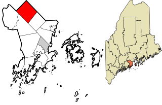
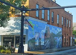
Appleton is a town in Knox County, Maine, United States. It is about 15 miles inland from Penobscot Bay and coastal towns such as Camden and Rockland, about 30 miles east of the state capital of Augusta. The population was 1,411 at the 2020 census.

<span class="mw-page-title-main">East Riverdale, Maryland</span> Census-designated place in Maryland, United States

East Riverdale is an unincorporated area and census-designated place (CDP) in Prince George's County, Maryland, United States. The population was 18,459 at the 2020 census.

<span class="mw-page-title-main">Crompond, New York</span> CDP in New York, United States

Crompond is a hamlet and census-designated place (CDP) located in the town of Yorktown in Westchester County, New York, United States. The population was 2,292 at the 2010 census.

<span class="mw-page-title-main">North Miami, Oklahoma</span> Town in Oklahoma, United States

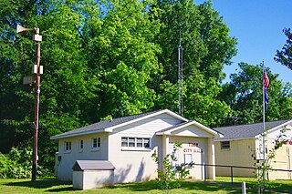
North Miami is a town in Ottawa County, Oklahoma, United States. The population was 290 at the 2020 census. The town is primarily a bedroom community for several larger towns in the county.

<span class="mw-page-title-main">Troy, South Carolina</span> Town in South Carolina, United States

Troy is a town in Greenwood County, South Carolina, United States. The population was 93 at the 2010 census.

<span class="mw-page-title-main">Clarks Hill, South Carolina</span> CDP in South Carolina, United States

Clarks Hill is a census-designated place (CDP) in McCormick County, South Carolina, United States. The population was 376 at the 2000 census.

<span class="mw-page-title-main">Modoc, South Carolina</span> CDP in South Carolina, United States

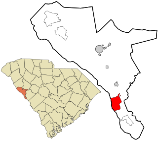
Modoc is a census-designated place (CDP) in McCormick County, South Carolina, United States. The population was 256 at the 2000 census, and 218 at the 2010 census, a decline of 14.8%.

<span class="mw-page-title-main">Parksville, South Carolina</span> Town in South Carolina, United States

Parksville is a town in McCormick County, South Carolina, United States. The population was 117 at the 2010 census.

<span class="mw-page-title-main">Plum Branch, South Carolina</span> Town in South Carolina, United States

Plum Branch is a town in McCormick County, South Carolina, United States. The population was 82 at the 2010 census.

<span class="mw-page-title-main">Saluda, South Carolina</span> Town in South Carolina, United States

Saluda is a town in Saluda County, South Carolina, United States, along the Little Saluda River. The population was 3,565 at the 2010 census. It is the county seat of Saluda County.

<span class="mw-page-title-main">Annona, Texas</span> Town in Texas, United States

Annona is a town in Red River County, Texas, United States. The population was 315 at the 2010 census.

<span class="mw-page-title-main">Windemere, Texas</span> Former CDP in Texas, United States

Windermere is a former census-designated place (CDP) in Travis County, Texas, United States. The population was 1,037 at the 2010 census. It has since largely been annexed by the city of Pflugerville.

<span class="mw-page-title-main">Sophia, West Virginia</span> Town in West Virginia, United States

Sophia is a town in Raleigh County, West Virginia, United States. It was incorporated in 1912. The population was 1,124 at the 2020 census.

Commonwealth is a town in Florence County, Wisconsin, United States. The population was 419 at the 2000 census. The unincorporated community of Commonwealth is located in the town.

<span class="mw-page-title-main">Woodville, Wisconsin</span> Village in Wisconsin, United States

Woodville is a village in St. Croix County, Wisconsin, United States. The population was 1,344 at the 2010 census.

References

  1. "ArcGIS REST Services Directory". United States Census Bureau. Retrieved October 15, 2022.
  2. 1 2 "Census Population API". United States Census Bureau. Retrieved October 15, 2022.
  3. 1 2 "U.S. Census website". United States Census Bureau . Retrieved January 31, 2008.
  4. "US Board on Geographic Names". United States Geological Survey. October 25, 2007. Retrieved January 31, 2008.
  5. "Explore Census Data". data.census.gov. Retrieved January 26, 2023.
  6. "National Register Information System". National Register of Historic Places . National Park Service. July 9, 2010.
  7. "US Gazetteer files: 2010, 2000, and 1990". United States Census Bureau. February 12, 2011. Retrieved April 23, 2011.
  8. "Census of Population and Housing". Census.gov. Retrieved June 4, 2015.
  9. "Explore Census Data". data.census.gov. Retrieved December 15, 2021.
  10. "2010 Census Population of Mccormick, South Carolina - CensusViewer". Archived from the original on August 8, 2016. Retrieved June 11, 2016.
  11. "Locations & Hours". Greenville County Library System. Retrieved June 13, 2019.