McCormick County, South Carolina

Last updated

McCormick County
McCormick County Courthouse, McCormick, South Carolina.jpg
McCormick County Seal.png
Motto: 
"The Natural Place Of Life"
Map of South Carolina highlighting McCormick County.svg
Location within the U.S. state of South Carolina
South Carolina in United States.svg
South Carolina's location within the U.S.
Coordinates: 33°54′N82°19′W / 33.90°N 82.32°W / 33.90; -82.32
CountryFlag of the United States.svg United States
StateFlag of South Carolina.svg  South Carolina
Founded1916
Named for Cyrus McCormick
Seat McCormick
Largest communityMcCormick
Area
  Total393.61 sq mi (1,019.4 km2)
  Land358.87 sq mi (929.5 km2)
  Water34.74 sq mi (90.0 km2)  8.83%
Population
 (2020)
  Total9,526
  Estimate 
(2023)
9,941
  Density26.54/sq mi (10.25/km2)
Time zone UTC−5 (Eastern)
  Summer (DST) UTC−4 (EDT)
Congressional district 3rd
Website mccormickcountysc.org

McCormick County is a county located in the U.S. state of South Carolina. As of the 2020 census, its population was 9,526, [1] making it the second-least populous county in South Carolina. Its county seat is McCormick. [2] The county was formed in 1916 from parts of Edgefield, Abbeville, and Greenwood counties. [3]

Contents

History

The county was founded in 1916 with portions of Edgefield, Abbeville, and Greenwood counties and was named after Cyrus McCormick. The largest community and county seat is McCormick.

Geography

McCormick County, South Carolina
Interactive map of McCormick County

According to the U.S. Census Bureau, the county has a total area of 393.61 square miles (1,019.4 km2), of which 358.87 square miles (929.5 km2) is land and 34.74 square miles (90.0 km2) (8.83%) is water. [4] It is the smallest county in South Carolina by land area and second-smallest by total area. McCormick County is in the Savannah River basin.

National protected area

State and local protected areas/sites

Major water bodies

Adjacent counties

Major highways

Demographics

Historical population
CensusPop.Note
1920 16,444
1930 11,471−30.2%
1940 10,367−9.6%
1950 9,577−7.6%
1960 8,629−9.9%
1970 7,955−7.8%
1980 7,797−2.0%
1990 8,86813.7%
2000 9,95812.3%
2010 10,2332.8%
2020 9,526−6.9%
2023 (est.)9,941 [1] 4.4%
U.S. Decennial Census [6]
1790–1960 [7] 1900–1990 [8]
1990–2000 [9] 2010 [10] 2020 [1]

2020 census

McCormick County racial composition [11]
RaceNum.Perc.
White (non-Hispanic)5,15554.12%
Black or African American (non-Hispanic)3,91641.11%
Native American 270.28%
Asian 360.38%
Pacific Islander 20.02%
Other/Mixed 2672.8%
Hispanic or Latino 1231.29%

As of the 2020 census, there were 9,526 people, 3,957 households, and 2,513 families residing in the county.

2010 census

At the 2010 census, there were 10,233 people, 4,027 households, and 2,798 families living in the county. [12] [10] The population density was 28.5 inhabitants per square mile (11.0/km2). There were 5,453 housing units at an average density of 15.2 per square mile (5.9/km2). [13] The racial makeup of the county was 49.7% black or African American, 48.7% white, 0.3% Asian, 0.1% Pacific islander, 0.1% American Indian, 0.2% from other races, and 0.9% from two or more races. Those of Hispanic or Latino origin made up 0.8% of the population. [12] In terms of ancestry, 10.7% were English, 10.2% were American, 10.2% were German, and 6.0% were Irish. [14]

Of the 4,027 households, 21.0% had children under the age of 18 living with them, 50.4% were married couples living together, 15.2% had a female householder with no husband present, 30.5% were non-families, and 27.4% of all households were made up of individuals. The average household size was 2.22 and the average family size was 2.65. The median age was 50.0 years. [12]

The median income for a household in the county was $35,858 and the median income for a family was $43,021. Males had a median income of $32,606 versus $28,067 for females. The per capita income for the county was $19,411. About 14.2% of families and 18.2% of the population were below the poverty line, including 37.6% of those under age 18 and 7.9% of those age 65 or over. [15]

2000 census

At the 2000 census, [16] there were 9,958 people, 3,558 households and 2,604 families living in the county. The population density was 28 people per square mile (11 people/km2). There were 4,459 housing units at an average density of 12 per square mile (4.6/km2). The racial makeup of the county was 53.88% Black or African American, 44.78% White, 0.07% Native American, 0.29% Asian, 0.03% Pacific Islander, 0.38% from other races, and 0.57% from two or more races. 0.86% of the population were Hispanic or Latino of any race.

There were 3,558 households, out of which 24.80% had children under the age of 18 living with them, 51.80% were married couples living together, 17.60% had a female householder with no husband present and 26.80% were non-families. 24.40% of all households were made up of individuals, and 10.20% had someone living alone who was 65 years of age or older. The average household size was 2.39 and the average family size was 2.82.

In the county, the population was spread out, with 19.50% under the age of 18, 8.30% from 18 to 24, 27.60% from 25 to 44, 28.10% from 45 to 64 and 16.50% who were 65 years of age or older. The median age was 41 years. For every 100 females there were 113.70 males. For every 100 females age 18 and over, there were 115.80 males.

The median income for a household in the county was $31,577, and the median income for a family was $38,822. Males had a median income of $28,824 versus $21,587 for females. The per capita income for the county was $14,770. About 15.10% of families and 17.90% of the population were below the poverty line, including 26.50% of those under age 18 and 11.90% of those age 65 or over.

Government and politics

Like most rural South Carolina counties with a tight Black-white population ratio, the Democratic Party has fared well in McCormick County compared to others across the South, especially with the national party's cultural turn to the left in the 2000s and 2010s. However, in 2016 Donald Trump won the county by one fewer vote than Barack Obama did in 2012, marking the first GOP victory in the area since Richard Nixon in 1972.

United States presidential election results for McCormick County, South Carolina [17]
Year Republican Democratic Third party
No.%No.%No.%
2020 2,95851.92%2,68747.17%520.91%
2016 2,65250.84%2,47947.53%851.63%
2012 2,46747.81%2,65351.41%400.78%
2008 2,43746.58%2,75552.66%400.76%
2004 2,39646.78%2,64851.70%781.52%
2000 1,70446.54%1,89651.79%611.67%
1996 1,10435.35%1,85859.49%1615.16%
1992 89929.46%1,84660.48%30710.06%
1988 1,17240.22%1,72259.09%200.69%
1984 1,18643.51%1,52655.98%140.51%
1980 79730.60%1,77468.10%341.31%
1976 64026.37%1,77473.09%130.54%
1972 1,30260.22%84439.04%160.74%
1968 46621.08%98844.69%75734.24%
1964 93965.34%49834.66%00.00%
1960 34733.79%68066.21%00.00%
1956 10211.74%48555.81%28232.45%
1952 57748.04%62451.96%00.00%
1948 00.00%304.04%71395.96%
1944 10.28%30786.72%4612.99%
1940 112.56%41997.44%00.00%
1936 81.20%65698.80%00.00%
1932 50.93%53099.07%00.00%
1928 203.14%61596.70%10.16%
1924 152.72%52094.37%162.90%
1920 00.00%557100.00%00.00%
1916 00.00%63799.69%20.31%

Economy

In 2022, the GDP was $278 million (about $27,961 per capita), [18] and the real GDP was $222.8 million (about $22,410 per capita) in chained 2017 dollars. [19]

As of April 2024, some of the largest employers in the county include Food Lion, the United States Department of Defense, and the United States Postal Service. [20]

Employment and Wage Statistics by Industry in McCormick County, South Carolina - Q3 2023 [20]
IndustryEmployment CountsEmployment Percentage (%)Average Annual Wage ($)
Accommodation and Food Services945.516,484
Administrative and Support and Waste Management and Remediation Services663.942,224
Agriculture, Forestry, Fishing and Hunting372.241,548
Construction925.450,336
Finance and Insurance231.350,648
Health Care and Social Assistance35120.534,996
Information50.370,304
Manufacturing1136.642,588
Other Services (except Public Administration)20512.028,600
Professional, Scientific, and Technical Services855.065,208
Public Administration38022.247,528
Real Estate and Rental and Leasing231.394,380
Retail Trade22613.223,764
Wholesale Trade130.834,268
Total1,713100.0%38,862

Communities

Towns

Census-designated places

Notable people

See also

Related Research Articles

<span class="mw-page-title-main">Saluda County, South Carolina</span> County in South Carolina, United States

Saluda County is a county in the U.S. state of South Carolina. As of the 2020 census, the population was 18,862. Its county seat is Saluda. The county was formed from northern and eastern portions of Edgefield County.

<span class="mw-page-title-main">Orangeburg County, South Carolina</span> County in South Carolina, United States

Orangeburg County is a county located in the U.S. state of South Carolina. As of the 2020 census, the population was 84,223. Its county seat is Orangeburg. The county was created in 1769.

<span class="mw-page-title-main">Marion County, South Carolina</span> County in South Carolina, United States

Marion County is a county located in the coastal plain of the U.S. state of South Carolina. As of the 2020 census, its population was 29,183. Its county seat is Marion. It is a majority-minority county.

<span class="mw-page-title-main">Lee County, South Carolina</span> County in South Carolina, United States

Lee County is a county located in the U.S. state of South Carolina. As of the 2020 census, its population was 16,531, making it the fifth-least populous county in South Carolina. Its county seat is Bishopville.

<span class="mw-page-title-main">Jasper County, South Carolina</span> County in South Carolina, United States

Jasper County is the southernmost county in the U.S. state of South Carolina. As of the 2020 census, the population was 28,791. Its county seat is Ridgeland and its largest community is Hardeeville. The county was formed in 1912 from portions of Hampton County and Beaufort County.

<span class="mw-page-title-main">Hampton County, South Carolina</span> County in South Carolina, United States

Hampton County is a rural county located in the U.S. state of South Carolina. As of the 2020 census, the population was 18,561. Its county seat is Hampton. It was named for Confederate Civil War general Wade Hampton, who in the late 1870s, with the ending of Reconstruction, was elected as governor of South Carolina.

<span class="mw-page-title-main">Greenwood County, South Carolina</span> County in South Carolina, United States

Greenwood County is a county located in the U.S. state of South Carolina. As of the 2020 census, its population was 69,351. Its county seat is Greenwood.

<span class="mw-page-title-main">Edgefield County, South Carolina</span> County in South Carolina, United States

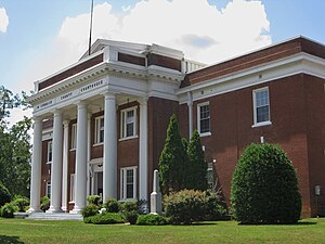
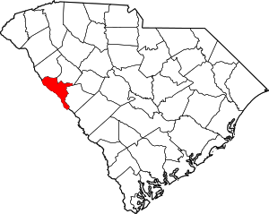
Edgefield County is a county located on the western border of the U.S. state of South Carolina. As of the 2020 census, its population was 25,657. Its county seat and largest community is Edgefield. The county was established on March 12, 1785.

<span class="mw-page-title-main">Dillon County, South Carolina</span> County in South Carolina, United States

Dillon County is a county located in the U.S. state of South Carolina. As of the 2020 census, the county's population was 28,292. The county seat is Dillon.

<span class="mw-page-title-main">Chester County, South Carolina</span> County in South Carolina, United States

Chester County is a county located in the U.S. state of South Carolina. As of the 2020 census, its population was 32,294. Its county seat is Chester.

<span class="mw-page-title-main">Allendale County, South Carolina</span> County in South Carolina, United States

Allendale County is a county located in the U.S. state of South Carolina. As of the 2020 census, the population was 8,039, making it the least populous county in South Carolina. Its county seat is Allendale.

<span class="mw-page-title-main">Aiken County, South Carolina</span> County in South Carolina, United States

Aiken County is a county in the U.S. state of South Carolina. As of the 2020 census, its population was 168,808. Its county seat and largest community is Aiken. Aiken County is a part of the Augusta-Richmond County, GA-SC Metropolitan Statistical Area. It is mostly in the Sandhills region, with the northern parts reaching in the Piedmont and southern parts reaching into the Coastal Plain.

<span class="mw-page-title-main">Abbeville County, South Carolina</span> County in South Carolina, United States

Abbeville County is a county located in the U.S. state of South Carolina. As of the 2020 census, its population was 24,295. Its county seat is Abbeville. It is the first county in the United States alphabetically. Abbeville County included in the Greenville-Spartanburg-Anderson, SC Combined Statistical Area, known colloquially as the Upstate or the Upcountry.

<span class="mw-page-title-main">Belvedere, South Carolina</span> Census-designated place in South Carolina, United States of America

Belvedere is a census-designated place (CDP) and suburb of North Augusta in Aiken County, South Carolina, United States. It is part of the Augusta, Georgia metropolitan area. The population was 5,792 at the 2010 census.

<span class="mw-page-title-main">Johnston, South Carolina</span> Town in South Carolina, United States

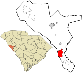
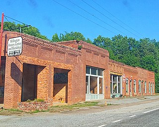
Johnston is a town in Edgefield County, South Carolina, United States. The population was 2,362 at the 2010 census. It is part of the Augusta, Georgia, metropolitan area. The town's official welcome sign states that it is "Peach Capital of the World".

<span class="mw-page-title-main">Murphys Estates, South Carolina</span> CDP in Edgefield County

Murphys Estates is a census-designated place (CDP) in Edgefield County, South Carolina, part of the larger Augusta metropolitan area. The population was 1,719 as of the 2020 census. The community is notable for having the largest number of Irish Travellers in the United States.

<span class="mw-page-title-main">Trenton, South Carolina</span> Town in South Carolina, United States

Trenton is a town in Edgefield County, South Carolina, United States. The population was 196 at the 2010 census, down from 226 in 2000.

<span class="mw-page-title-main">McCormick, South Carolina</span> Town in South Carolina, United States

McCormick is a town in McCormick County, South Carolina, United States. The population was 2,232 at the 2020 census. It is the county seat of McCormick County. The town of McCormick is named for inventor Cyrus McCormick.

<span class="mw-page-title-main">Modoc, South Carolina</span> CDP in South Carolina, United States

Modoc is a census-designated place (CDP) in McCormick County, South Carolina, United States. The population was 256 at the 2000 census, and 218 at the 2010 census, a decline of 14.8%.

<span class="mw-page-title-main">Willington, South Carolina</span> CDP in South Carolina, United States

Willington is a census-designated place (CDP) in McCormick County, South Carolina, United States. The population was 177 at the 2000 census.

References

  1. 1 2 3 "QuickFacts: McCormick County, South Carolina". United States Census Bureau. Retrieved March 22, 2024.
  2. "Find a County". National Association of Counties. Archived from the original on May 31, 2011. Retrieved June 7, 2011.
  3. "South Carolina: Individual County Chronologies". South Carolina Atlas of Historical County Boundaries. The Newberry Library. 2009. Archived from the original on January 3, 2017. Retrieved March 21, 2015.
  4. "2020 County Gazetteer Files – South Carolina". United States Census Bureau. August 23, 2022. Retrieved September 10, 2023.
  5. 1 2 3 "SCDNR Public Lands". www2.dnr.sc.gov. Retrieved April 1, 2023.
  6. "U.S. Decennial Census". United States Census Bureau. Retrieved March 18, 2015.
  7. "Historical Census Browser". University of Virginia Library. Retrieved March 18, 2015.
  8. Forstall, Richard L., ed. (March 27, 1995). "Population of Counties by Decennial Census: 1900 to 1990". United States Census Bureau. Retrieved March 18, 2015.
  9. "Census 2000 PHC-T-4. Ranking Tables for Counties: 1990 and 2000" (PDF). United States Census Bureau. April 2, 2001. Archived (PDF) from the original on October 9, 2022. Retrieved March 18, 2015.
  10. 1 2 "State & County QuickFacts". United States Census Bureau. Archived from the original on July 17, 2011. Retrieved November 25, 2013.
  11. "Explore Census Data". data.census.gov. Retrieved December 15, 2021.
  12. 1 2 3 "DP-1 Profile of General Population and Housing Characteristics: 2010 Demographic Profile Data". United States Census Bureau. Archived from the original on February 13, 2020. Retrieved March 11, 2016.
  13. "Population, Housing Units, Area, and Density: 2010 - County". United States Census Bureau. Archived from the original on February 13, 2020. Retrieved March 11, 2016.
  14. "DP02 SELECTED SOCIAL CHARACTERISTICS IN THE UNITED STATES – 2006-2010 American Community Survey 5-Year Estimates". United States Census Bureau. Archived from the original on February 13, 2020. Retrieved March 11, 2016.
  15. "DP03 SELECTED ECONOMIC CHARACTERISTICS – 2006-2010 American Community Survey 5-Year Estimates". United States Census Bureau. Archived from the original on February 13, 2020. Retrieved March 11, 2016.
  16. "U.S. Census website". United States Census Bureau . Retrieved May 14, 2011.
  17. Leip, David. "Dave Leip's Atlas of U.S. Presidential Elections". uselectionatlas.org. Retrieved March 13, 2018.
  18. U.S. Bureau of Economic Analysis (January 1, 2001). "Gross Domestic Product: All Industries in McCormick County, SC". FRED, Federal Reserve Bank of St. Louis. Retrieved May 4, 2024.
  19. U.S. Bureau of Economic Analysis (January 1, 2001). "Real Gross Domestic Product: All Industries in McCormick County, SC". FRED, Federal Reserve Bank of St. Louis. Retrieved May 4, 2024.
  20. 1 2 "McCormick County" (PDF). Community Profiles (04000065). Columbia, SC: S.C. Department of Employment & Workforce - Business Intelligence Department. April 19, 2024.