Orangeburg, South Carolina

Last updated

Orangeburg, South Carolina
Central Business District.jpg
Central Business District of Orangeburg
Orangeburg, SC City Seal.jpg
Nickname: 
The Garden City
SCMap-doton-Orangeburg.PNG
Coordinates: 33°29′49″N80°51′44″W / 33.49694°N 80.86222°W / 33.49694; -80.86222
Country Flag of the United States.svg United States
State Flag of South Carolina.svg South Carolina
County Orangeburg
Government
   Mayor Michael C. Butler
   City Council
Members
Area
[1]
  Total9.02 sq mi (23.36 km2)
  Land9.01 sq mi (23.34 km2)
  Water0.01 sq mi (0.02 km2)
Elevation
[2]
243 ft (74 m)
Population
 (2020) [3]
  Total13,240
  Density1,469.15/sq mi (567.23/km2)
Time zone UTC−5 (EST)
  Summer (DST) UTC−4 (EDT)
ZIP codes
29115-29118
Area code(s) 803, 839
FIPS code 45-53080 [4]
GNIS feature ID1249990 [2]
Website www.orangeburg.sc.us
Russell Street, downtown's main street Russell Street Orangeburg SC.jpg
Russell Street, downtown's main street
Downtown Loop Downtown Loop.jpg
Downtown Loop

Orangeburg, also known as The Garden City, is the principal city in and the county seat of Orangeburg County, South Carolina, United States. [5] The population of the city was 13,964 according to the 2020 census. [6] The city is located 37 miles southeast of Columbia, on the north fork of the Edisto River.

Contents

Two historically black institutions of higher education are located in Orangeburg: Claflin University (a liberal arts college) and South Carolina State University (a public university).

History

18th century

European settlement in this area started in 1704 when George Sterling set up a post here for fur trade with Native Americans. To encourage settlement, the General Assembly of the Province of South Carolina in 1730 organized the area as a township, naming it Orangeburg for William IV, Prince of Orange, the son-in-law of King George II of Great Britain. In 1735, a colony of 200 Swiss, German and Dutch immigrants formed a community near the banks of the North Edisto River. The site was attractive because of the fertile soil and the abundance of wildlife. The river provided the all-important transportation waterway to the port of Charleston on the Atlantic coast for the area's agriculture and lumber products, and for shipping goods upriver. The town soon became a well-established and successful colony, composed chiefly of small yeomen farmers.

Orangeburg's first church was established by a German Lutheran congregation. It later identified as an Anglican Church, which was the established church and exempt from colonial taxation. The church building was erected prior to 1763 in the center of the village; it was destroyed by fighting during the Revolutionary War. A new church was built; during the Civil War, it was used as a smallpox hospital by General William Tecumseh Sherman on his march through with Union forces.

19th century

After the American Revolution, the character of the county changed dramatically. Invention by Eli Whitney of a mass-produced cotton gin for processing short-staple or "green seed" cotton made this type of cotton profitable. It was easily grown in the upland areas, and the county was rapidly developed into large cotton plantations. Agricultural labor was provided by enslaved African Americans, many brought into the area in a forced migration from the coastal areas or the Upper South via the domestic slave trade. Slaves became the majority of population in the county and city. Freed after the Civil War, blacks began to gain educations, and two colleges were established in the city, the second designated as a land grant institution for all black students in the state under segregation. Blacks were also subject to Jim Crow laws passed by the Democrat-dominated state legislature; they were deprived of their ability to vote by South Carolina's disenfranchising constitution passed at the turn of the 20th century, which erected barriers to voter registration. In 1919 The Orangeburg Regional Medical Center opened. This area is also known for its extremely rich soil.

20th century

A controversial Confederate flag in Orangeburg owned by the Sons of Confederate Veterans. Confederate Flag, Orangeburg, SC.jpg
A controversial Confederate flag in Orangeburg owned by the Sons of Confederate Veterans.

Efforts by blacks to regain civil rights increased in the postwar period after World War II. In the 1960s, Orangeburg was a major center of Civil Rights Movement activities by students from both Claflin College and South Carolina State College as well as black residents of the city. After the US Supreme Court ruling in Brown v. Board of Education (1954) declaring segregation in public schools to be unconstitutional, local blacks sought integration of local schools in 1956. Whites retaliated economically, sometimes firing activists or evicting them from rental housing. College students came to their support with hunger strikes, boycotts, and mass marches. In 1960, over 400 students were arrested on sit-ins and integration marches organized by the Congress of Racial Equality (CORE).

In August 1963, the Orangeburg Freedom Movement (OFM), chaired by Harlowe Caldwell of the NAACP, submitted 10 pro-integration demands to the Orangeburg Mayor and City Council. After negotiations failed, mass demonstrations similar to those in the Birmingham campaign in Alabama resulted in more than 1,300 arrests. Local efforts to end segregation in public places continued, particularly after Congress passed the Civil Rights Act of 1964. On February 8, 1968, after days of protests against a segregated bowling alley, violence broke out near the bowling alley as police attacked Black students from South Carolina State. Police opened fire on a crowd of students, killing Samuel Hammond, Henry Smith, and Delano Middleton, and wounding 27 others in what became known as the "Orangeburg Massacre". [7]

21st century

In May 2000, the city created the Orangeburg County Community of Character initiative. It is a collaborative effort in community development by the Downtown Orangeburg Revitalization Association (DORA), The Times and Democrat newspaper, the Orangeburg County Chamber of Commerce, and the Orangeburg County Development Commission. [8] In 2005, the National Civic League awarded Orangeburg County the All-America City Award which recognizes and encourages civic excellence. It honors communities in which citizens, government, businesses, and non-profit organizations demonstrate successful resolution of critical community issues. [9]

In 2007, Orangeburg hosted the first Democratic U.S. presidential candidate debate of the campaign season at Martin Luther King Jr. Auditorium on the campus of South Carolina State University; future president Barack Obama was one of the debaters. In 2021, President Joe Biden visited Orangeburg to deliver a commencement address at South Carolina State. [10]

Geography

According to the United States Census Bureau, the city has a total area of 8.3 square miles (21.5 km2), of which 8.3 square miles (21.5 km2) is land and 0.12% is water.

Climate

The climate in this area is characterized by relatively high temperatures and evenly distributed precipitation throughout the year. According to the Köppen Climate Classification system, Orangeburg has a humid subtropical climate, abbreviated Cfa on climate maps. [11]

Climate data for Orangeburg, South Carolina (1991–2020 normals, extremes 1953–present)
MonthJanFebMarAprMayJunJulAugSepOctNovDecYear
Record high °F (°C)84
(29)
86
(30)
92
(33)
97
(36)
102
(39)
105
(41)
105
(41)
108
(42)
102
(39)
99
(37)
91
(33)
90
(32)
108
(42)
Mean daily maximum °F (°C)59.6
(15.3)
63.2
(17.3)
70.2
(21.2)
77.8
(25.4)
84.8
(29.3)
90.4
(32.4)
92.9
(33.8)
91.7
(33.2)
86.9
(30.5)
78.6
(25.9)
69.0
(20.6)
61.7
(16.5)
77.2
(25.1)
Daily mean °F (°C)48.1
(8.9)
51.4
(10.8)
57.9
(14.4)
65.1
(18.4)
72.7
(22.6)
79.3
(26.3)
82.2
(27.9)
81.4
(27.4)
76.2
(24.6)
66.4
(19.1)
56.3
(13.5)
50.0
(10.0)
65.6
(18.7)
Mean daily minimum °F (°C)36.6
(2.6)
39.6
(4.2)
45.6
(7.6)
52.4
(11.3)
60.5
(15.8)
68.2
(20.1)
71.5
(21.9)
71.2
(21.8)
65.6
(18.7)
54.1
(12.3)
43.6
(6.4)
38.4
(3.6)
53.9
(12.2)
Record low °F (°C)2
(−17)
9
(−13)
6
(−14)
27
(−3)
35
(2)
47
(8)
54
(12)
53
(12)
40
(4)
27
(−3)
18
(−8)
6
(−14)
2
(−17)
Average precipitation inches (mm)3.96
(101)
3.86
(98)
3.89
(99)
3.29
(84)
4.04
(103)
5.47
(139)
5.80
(147)
5.29
(134)
4.49
(114)
3.52
(89)
3.09
(78)
3.78
(96)
50.48
(1,282)
Average snowfall inches (cm)0.1
(0.25)
0.0
(0.0)
0.0
(0.0)
0.0
(0.0)
0.0
(0.0)
0.0
(0.0)
0.0
(0.0)
0.0
(0.0)
0.0
(0.0)
0.0
(0.0)
0.0
(0.0)
0.0
(0.0)
0.1
(0.25)
Average precipitation days (≥ 0.01 in)10.29.69.48.28.911.011.011.18.57.67.510.0113.0
Source: NOAA [12] [13]

Demographics

Historical population
CensusPop.Note
1860 997
1870 246−75.3%
1880 2,140769.9%
1890 2,96438.5%
1900 4,45550.3%
1910 5,90632.6%
1920 7,29023.4%
1930 8,77620.4%
1940 10,52119.9%
1950 15,32245.6%
1960 13,852−9.6%
1970 13,252−4.3%
1980 14,93312.7%
1990 13,739−8.0%
2000 12,765−7.1%
2010 13,9649.4%
2020 13,240−5.2%
U.S. Decennial Census [3]

2020 census

Orangeburg, South Carolina – Racial and ethnic composition
Note: the US Census treats Hispanic/Latino as an ethnic category. This table excludes Latinos from the racial categories and assigns them to a separate category. Hispanics/Latinos may be of any race.
Race / Ethnicity (NH = Non-Hispanic)Pop 2000 [14] Pop 2010 [15] Pop 2020 [16] % 2000% 20102020
White alone (NH)3,7582,8912,23729.44%20.70%16.90%
Black or African American alone (NH)8,57710,41110,11967.19%74.56%76.43%
Native American or Alaska Native alone (NH)1724480.13%0.17%0.36%
Asian alone (NH)1452312771.14%1.65%2.09%
Pacific Islander alone (NH)57140.04%0.05%0.11%
Some Other Race alone (NH)3012360.24%0.09%0.27%
Mixed Race or Multi-Racial (NH)681222490.53%0.87%1.88%
Hispanic or Latino (any race)1652662601.29%1.90%1.96%
Total12,76513,96413,240100.00%100.00%100.00%

As of the 2020 United States census, there were 13,240 people, 4,455 households, and 2,283 families residing in the city.

2010 census

As of the census [4] of 2010, there were 13,964 people, 4,512 households, and 2,526 families residing in the city. The population density was 1648.8 There were 5,168 housing units at an average density of 623.1 per square mile (240.6/km2). The racial makeup of the city was 75.04% African American, 19.2% White, 0.18% Native American, 1.74% Asian, 0.05% Pacific Islander, 0.79% from other races, and 1.1% from two or more races. Hispanic or Latino of any race were 1.9% of the population.

There were 4,421 households, out of which 18.9% had children under the age of 18 living with them, 33.5% were married couples living together, 18.8% had a female householder with no husband present, and 44.0% were non-families. 35.2% of all households were made up of individuals, and 13.1% had someone living alone who was 65 years of age or older. The average household size was 2.23 and the average family size was 2.88.

In the city, the population was spread out, with 17.7% under the age of 18, 28.6% from 18 to 24, 21.0% from 25 to 44, 17.5% from 45 to 64, and 15.2% who were 65 years of age or older. The median age was 28 years. For every 100 females, there were 76.2 males. For every 100 females age 18 and over, there were 71.0 males.

The median income for a household in the city was $30,306, and the median income for a family was $37,008. Males had a median income of $30,310 versus $21,935 for females. The per capita income for the city was $15,263. About 17.9% of families and 24.7% of the population were below the poverty line, including 34.7% of those under age 18 and 14.8% of those age 65 or over.

Government and crime

Government

The city operates under the council-manager form of government. The governing body is composed of a mayor and six members. The mayor is determined through a nonpartisan, at-large election for a four-year term of office while Council Members are chosen through nonpartisan, single-member district (SMD) elections. Council members are elected to staggered four-year terms of office.

The City council is a legislative body, establishing policies with recommendations from the professional city administrator, who is hired by the council. The city administrator acts as the chief administrator of the council's policies implemented through the administrative control of city departments given to him by ordinance.

Mayor

Council Members

State Senators

Crime

The following table shows Orangeburg's crime rate in 6 crimes that Morgan Quitno uses in its calculations for "America's most dangerous cities" rankings, in comparison to 10,000 people. The statistics provided are not for the actual number of crimes committed, but for the number of crimes committed per capita. [17]

CrimeOrangeburg, SC (2009)per 10,000 people
Murder1.75
Rape96.78
Robbery3625.61
Assault3526.36
Burglary232174.73
Automobile Theft6548.95
Arson21.51

Education

Colleges and universities

Public schools

Charter schools

Private schools

Library

Orangeburg has a public library, a branch of the Orangeburg County Library. [19]

Media

The Times and Democrat serves as the daily newspaper for the Orangeburg area.

Transportation

Terminals

Highways

Events and attractions

St. Paul's United Methodist Church, Orangeburg, South Carolina St paul 1264.JPG
St. Paul's United Methodist Church, Orangeburg, South Carolina

Garden

The Edisto Memorial Gardens displays past and current award-winning roses from the All-American Rose Selections. Some 4,000 plants representing at least 75 labeled varieties of roses are always on display in the Gardens. The site was first developed in the 1920s with some azaleas on 5 acres (20,000 m2) of land. A playground was added in 1922, and a greenhouse and nursery facility in 1947. To extend the season of beauty, the first rose garden was planted in 1951. Currently, there are more than 50 beds of roses ranging from miniatures from grandiflora to climbers on over 150 acres (0.61 km2) of land.

Museum

The IP Stanback Museum & Planetarium, named for the first African-American chairman of the university's board of trustees, Israel Pinkney Stanback, had its origin in the basement of the then South Carolina State College's library in the early 1970s. The Museum and Planetarium is located on the campus of South Carolina State University and signifies their commitment to community service. The Museum's exhibition area is one of the largest in the state. Its forty-foot planetarium dome, located across the foyer adjacent to the galleries, has an auditorium capacity of eighty-two seats and a Minolta IIB Planetarium Projector. The building is easily accessible to the handicapped and is a uniquely adaptable facility, capable of hosting many different types of presentations.

Festivals

The Orangeburg Festival of Roses began as a vision held by a group of citizens seeking a way to enhance the development of Orangeburg and improve the quality of life for its residents. As a result of that vision, the first festival was held in 1972. The Greater Orangeburg Chamber of Commerce was the sole sponsor of that first festival. At present the City of Orangeburg and the Orangeburg County Chamber of Commerce are co-sponsors of the event. The festival includes such events as a river race, a basscatcher tournament, the Princess of Roses pageant, and various sports tournaments.

During the winter in Orangeburg, more festivities get under way when raccoon hunters from throughout the Southeast gather for the Grand American Coon Hunt. Also on the "Top Twenty" list, the hunt, which takes place each year in early January, in the largest field trial for coon dogs in the United States and is a qualifying event for the World Coon Hunt.

Landmarks

The following notable buildings and districts are listed on the National Register of Historic Places: [20]

Notable people

Related Research Articles

<span class="mw-page-title-main">Macon County, Alabama</span> County in Alabama, United States

Macon County is a county located in the east central part of the U.S. state of Alabama. As of the 2020 census, the population was 19,532. Its county seat is Tuskegee. Its name is in honor of Nathaniel Macon, a member of the United States Senate from North Carolina.

<span class="mw-page-title-main">Sumter County, South Carolina</span> County in South Carolina, United States

Sumter County is a county located in the U.S. state of South Carolina. As of the 2020 census, the population was 105,556. Its county seat is Sumter.

<span class="mw-page-title-main">Orangeburg County, South Carolina</span> County in South Carolina, United States

Orangeburg County is a county located in the U.S. state of South Carolina. As of the 2020 census, the population was 84,223. Its county seat is Orangeburg. The county was created in 1769.

<span class="mw-page-title-main">Jasper County, South Carolina</span> County in South Carolina, United States

Jasper County is the southernmost county in the U.S. state of South Carolina. As of the 2020 census, the population was 28,791. Its county seat is Ridgeland and its largest community is Hardeeville. The county was formed in 1912 from portions of Hampton County and Beaufort County.

<span class="mw-page-title-main">Dorchester County, South Carolina</span> County in South Carolina, United States

Dorchester County is a county located in the U.S. state of South Carolina. As of the 2020 census, the population was 161,540. Its county seat is St. George.

<span class="mw-page-title-main">Colleton County, South Carolina</span> County in South Carolina, United States

Colleton County is in the Lowcountry region of the U.S. state of South Carolina. As of the 2020 census, the population was 38,604. Its county seat is Walterboro. The county is named after Sir John Colleton, 1st Baronet, one of the eight Lords Proprietor of the Province of Carolina. After two previous incarnations, the current Colleton County was created in 1800.

<span class="mw-page-title-main">Clarendon County, South Carolina</span> County in South Carolina, United States

Clarendon County is a county located below the fall line in the Coastal Plain region of U.S. state of South Carolina. As of the 2020 census, its population was 31,144. Its county seat is Manning.

<span class="mw-page-title-main">Berkeley County, South Carolina</span> County in South Carolina, United States

Berkeley County is a county in the U.S. state of South Carolina. As of the 2020 census, its population was 229,861. Its county seat is Moncks Corner, and the largest community is Goose Creek. After two previous incarnations of Berkeley County, the current county was created in 1882. Berkeley County is included in the Charleston-North Charleston, SC Metropolitan Statistical Area.

<span class="mw-page-title-main">Beaufort County, South Carolina</span> County in South Carolina, United States

Beaufort County is a county in the U.S. state of South Carolina. As of the 2020 census, its population was 187,117. Its county seat is Beaufort and its largest community is Hilton Head Island.

<span class="mw-page-title-main">Barnwell County, South Carolina</span> County in South Carolina, United States

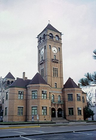
Barnwell County is a county in the U.S. state of South Carolina. As of the 2020 census, its population was 20,589. It is located in the Central Savannah River Area. Its county seat is Barnwell.

<span class="mw-page-title-main">Bamberg County, South Carolina</span> County in South Carolina, United States

Bamberg County is a county located in the southwestern portion of U.S. state of South Carolina. As of the 2020 census, the population was 13,311, making the rural county the fourth-least populous of any in South Carolina. Its county seat is Bamberg.

<span class="mw-page-title-main">Aiken County, South Carolina</span> County in South Carolina, United States

Aiken County is a county in the U.S. state of South Carolina. As of the 2020 census, its population was 168,808. Its county seat and largest community is Aiken. Aiken County is a part of the Augusta-Richmond County, GA-SC Metropolitan Statistical Area. It is mostly in the Sandhills region, with the northern parts reaching in the Piedmont and southern parts reaching into the Coastal Plain.

<span class="mw-page-title-main">Abbeville County, South Carolina</span> County in South Carolina, United States

Abbeville County is a county located in the U.S. state of South Carolina. As of the 2020 census, its population was 24,295. Its county seat is Abbeville. It is the first county in the United States alphabetically. Abbeville County included in the Greenville-Spartanburg-Anderson, SC Combined Statistical Area, known colloquially as the Upstate or the Upcountry.

<span class="mw-page-title-main">Gastonia, North Carolina</span> City in North Carolina, United States

Gastonia is the most populous city in and county seat of Gaston County, North Carolina, United States. It is the second-largest satellite city of the Charlotte area, behind Concord. The population was 80,411 in the 2020 census, up from 71,741 in 2010. Gastonia is the 13th-most populous city in North Carolina. It is part of the Charlotte-Concord-Gastonia, NC-SC Metropolitan Statistical Area, which is part of the Charlotte-Concord, NC-SC Combined Statistical Area.

<span class="mw-page-title-main">Barnwell, South Carolina</span> City in South Carolina, United States

Barnwell is a city in and county seat of Barnwell County, South Carolina, United States, located along U.S. Route 278. The population was 4,750 at the 2010 census.

<span class="mw-page-title-main">Sumter, South Carolina</span> City in Sumter County, South Carolina, United States

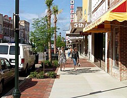
Sumter is a city in and the county seat of Sumter County, South Carolina, United States. The city makes up the Sumter, SC Metropolitan Statistical Area. Sumter County, along with Clarendon and Lee counties, form the core of Sumter–Lee–Clarendon tri-county area of South Carolina that includes three counties straddling the border of the Sandhills, Pee Dee, and Lowcountry regions. The population was 43,463 at the 2020 census, making it the 9th-most populous city in the state.

<span class="mw-page-title-main">Kingstree, South Carolina</span> City in South Carolina, United States

Kingstree is a city and the county seat of Williamsburg County, South Carolina, United States. The population was 3,328 at the 2010 census.

<span class="mw-page-title-main">Augusta, Georgia</span> Consolidated city-county in the United States

Augusta is a consolidated city-county on the central eastern border of the U.S. state of Georgia. The city lies directly across the Savannah River from North Augusta, South Carolina at the head of its navigable portion. Georgia's third most populous city, Augusta is located in the Fall Line section of the state.

Gloria Blackwell, also known as Gloria Rackley, was an African-American civil rights activist and educator. She was at the center of the Civil Rights Movement in Orangeburg, South Carolina during the 1960s, attracting some national attention and a visit by Dr. Martin Luther King of the Southern Christian Leadership Conference. Her activities were widely covered by the local press.

<span class="mw-page-title-main">Curtis C. Robinson</span> American pharmacist and U.S. Army Air Force officer (1919 - 2009)

Curtis Christopher Robinson was an American pharmacist and U.S. Army Air Force officer. He served as a fighter pilot during World War II with the 332nd Fighter Group's 99th Fighter Squadron, a component of the Tuskegee Airmen.

References

  1. "ArcGIS REST Services Directory". United States Census Bureau. Retrieved October 15, 2022.
  2. 1 2 U.S. Geological Survey Geographic Names Information System: Orangeburg, South Carolina
  3. 1 2 "Census Population API". United States Census Bureau. Retrieved October 15, 2022.
  4. 1 2 "U.S. Census website". United States Census Bureau . Retrieved January 31, 2008.
  5. "Find a County". National Association of Counties. Archived from the original on May 3, 2015. Retrieved June 7, 2011.
  6. "Orangeburg City Quick Fact". census.gov. U.S. Government. Retrieved July 2, 2022.
  7. "History & Timeline", Civil Rights Movement Archive
  8. "Our Mission". Archived from the original on January 15, 2016.
  9. "County Wins All-America City Award". The Times and Democrat . June 27, 2005.
  10. "U.S. President Joseph R. Biden Jr. to address SC State graduates at Dec. 17 commencement". December 11, 2021.
  11. "Orangeburg, South Carolina Köppen Climate Classification (Weatherbase)". Weatherbase.
  12. "NowData – NOAA Online Weather Data". National Oceanic and Atmospheric Administration. Retrieved May 14, 2021.
  13. "Station: Orangeburg 2, SC". U.S. Climate Normals 2020: U.S. Monthly Climate Normals (1991-2020). National Oceanic and Atmospheric Administration. Retrieved May 14, 2021.
  14. "P004 Hispanic or Latino, and Not Hispanic or Latino by Race – 2000: DEC Summary File 1 – Orangeburg city, South Carolina". United States Census Bureau .
  15. "P2 Hispanic or Latino, and Not Hispanic or Latino by Race – 2010: DEC Redistricting Data (PL 94-171) – Orangeburg city, South Carolina". United States Census Bureau .
  16. "P2 Hispanic or Latino, and Not Hispanic or Latino by Race – 2010: DEC Redistricting Data (PL 94-171) – Orangeburg city, South Carolina". United States Census Bureau .
  17. "Orangeburg, South Carolina (SC 29117) profile: population, maps, real estate, averages, homes, statistics, relocation, travel, jobs, hospitals, schools, crime, moving, houses, news, sex offenders". City-data.com. Retrieved August 21, 2014.
  18. "Claflin University Receives Top State HBCU Ranking by Washington Monthly" Archived 2015-03-09 at archive.today , Claflin University, 28 August 2014
  19. "Locations & Hours". Greenville County Library System. Retrieved June 13, 2019.
  20. "National Register Information System". National Register of Historic Places . National Park Service. July 9, 2010.
  21. Weber, Bruce. "Israel Hicks, Director of August Wilson’s Cycle, Dies at 66", The New York Times , July 7, 2010. Accessed July 8, 2010.
  22. Roberts, Sam (October 11, 2016). "Benjamin Payton, Transformative Leader of Tuskegee University, Dies". The New York Times. Retrieved June 18, 2018.
  23. "Tuskegee Airmen Pilot Roster". CAF Rise Above. Retrieved August 11, 2020.
  24. Legacy - The Washington Post. "CURTIS C. "CC" ROBINSON." https://www.legacy.com/us/obituaries/washingtonpost/name/curtis-robinson-obituary?pid=172778397

Further reading