Marion County, South Carolina

Last updated

Marion County
Mt. Olive Baptist Church, 301 Church St., Mullins, South Carolina.JPG
Marion County Seal.jpg
Marion County Logo.png
Motto: 
"It's just right!"
Map of South Carolina highlighting Marion County.svg
Location within the U.S. state of South Carolina
South Carolina in United States.svg
South Carolina's location within the U.S.
Coordinates: 34°05′N79°21′W / 34.08°N 79.35°W / 34.08; -79.35
CountryFlag of the United States.svg United States
StateFlag of South Carolina.svg  South Carolina
Founded1798
Named for Francis Marion
Seat Marion
Largest communityMarion
Area
  Total494.17 sq mi (1,279.9 km2)
  Land489.37 sq mi (1,267.5 km2)
  Water4.80 sq mi (12.4 km2)  0.97%
Population
 (2020)
  Total29,183
  Estimate 
(2023)
28,508
  Density59.63/sq mi (23.02/km2)
Time zone UTC−5 (Eastern)
  Summer (DST) UTC−4 (EDT)
Congressional district 7th
Website www.marionsc.org

Marion County is a county located in the coastal plain of the U.S. state of South Carolina. As of the 2020 census, its population was 29,183. [1] Its county seat is Marion. [2] It is a majority-minority county.

Contents

History

Early European traders in the Carolinas settled along the Pee Dee River from the 17th century, including in an isolated area called Sandy Bluff. They did business with numerous tribes, including the Choctaw and Chickasaw to the South. Crossed by several rivers, the county was organized by European Americans in 1785 soon after the American Revolutionary War and was originally known as Liberty County. However, four years later it was renamed as Marion County, in honor of Brigadier General Francis Marion, [3] the famous "Swamp Fox" and a hero of the American Revolutionary War. In 1910, a portion of the county was taken to be organized as adjacent Dillon County.

Geography

Marion County, South Carolina
Interactive map of Marion County

According to the U.S. Census Bureau, the county has a total area of 494.17 square miles (1,279.9 km2), of which 489.37 square miles (1,267.5 km2) is land and 4.80 square miles (12.4 km2) (0.97%) is water. [4]

National protected area

State and local protected areas

Major water bodies

Adjacent counties

Major highways

Demographics

Historical population
CensusPop.Note
1800 6,914
1810 8,88428.5%
1820 10,20114.8%
1830 11,2089.9%
1840 13,93224.3%
1850 17,40724.9%
1860 21,19021.7%
1870 22,1604.6%
1880 34,10753.9%
1890 29,976−12.1%
1900 35,18117.4%
1910 20,596−41.5%
1920 23,72115.2%
1930 27,22114.8%
1940 30,10710.6%
1950 33,11010.0%
1960 32,014−3.3%
1970 30,270−5.4%
1980 34,17912.9%
1990 33,899−0.8%
2000 35,4664.6%
2010 33,062−6.8%
2020 29,183−11.7%
2023 (est.)28,508 [1] −2.3%
U.S. Decennial Census [6]
1790–1960 [7] 1900–1990 [8]
1990–2000 [9] 2010 [10] 2020 [1]

2020 census

Marion County racial composition [11]
RaceNum.Perc.
White (non-Hispanic)11,08037.97%
Black or African American (non-Hispanic)16,33355.97%
Native American 1090.37%
Asian 1280.44%
Other/Mixed 8232.82%
Hispanic or Latino 7102.43%

As of the 2020 census, there were 29,183 people, 11,600 households, and 7,532 families residing in the county.

2010 census

At the 2010 census, there were 33,062 people, 13,058 households, and 8,881 families living in the county. [12] [10] The population density was 67.6 inhabitants per square mile (26.1/km2). There were 14,953 housing units at an average density of 30.6 per square mile (11.8/km2). [13] The racial makeup of the county was 55.9% black or African American, 40.6% white, 0.5% Asian, 0.4% American Indian, 1.3% from other races, and 1.2% from two or more races. Those of Hispanic or Latino origin made up 2.4% of the population. [12] In terms of ancestry, 7.8% were American, 6.3% were English, and 5.2% were Irish. [14]

Of the 13,058 households, 33.4% had children under the age of 18 living with them, 38.0% were married couples living together, 24.9% had a female householder with no husband present, 32.0% were non-families, and 28.5% of all households were made up of individuals. The average household size was 2.52 and the average family size was 3.09. The median age was 39.9 years. [12]

The median income for a household in the county was $30,629 and the median income for a family was $38,043. Males had a median income of $32,414 versus $24,929 for females. The per capita income for the county was $16,653. About 21.4% of families and 25.1% of the population were below the poverty line, including 36.8% of those under age 18 and 19.1% of those age 65 or over. [15]

2000 census

At the 2000 census, [16] there were 35,466 people, 13,301 households, and 9,510 families living in the county. The population density was 72 people per square mile (28 people/km2). There were 15,143 housing units at an average density of 31 per square mile (12/km2). The racial makeup of the county was 56.35% Black or African American, 41.69% White, 0.25% Native American, 0.28% Asian, 0.01% Pacific Islander, 0.90% from other races, and 0.52% from two or more races. 1.79% of the population were Hispanic or Latino of any race.

There were 13,301 households, out of which 32.20% had children under the age of 18 living with them, 43.30% were married living together, 23.60% had a female householder with no husband present, and 28.50% were non-families. 25.40% of all households were made up of individuals, and 9.70% had someone living alone who was 65 years of age or older. The average household size was 2.64 and the average family size was 3.16.

In the county, the population was spread out, with 27.60% under the age of 18, 9.70% from 18 to 24, 26.80% from 25 to 44, 23.80% from 45 to 64, and 12.10% who were 65 years of age or older. The median age was 35 years. For every 100 females there were 85.90 males. For every 100 females age 18 and over, there were 80.40 males.

The median income for a household in the county was $26,526, and the median income for a family was $32,932. Males had a median income of $26,133 versus $18,392 for females. The per capita income for the county was $13,878. About 18.90% of families and 23.20% of the population were below the poverty line, including 33.30% of those under age 18 and 23.50% of those age 65 or over.

According to the 2010 U.S. Religious Census, residents of Marion County are predominately Protestant. But the county had the highest concentration of followers of the Baháʼí Faith of any county in the United States, at 5.5%. [17]

Government and politics

United States presidential election results for Marion County, South Carolina [18]
Year Republican Democratic Third party
No.%No.%No.%
2020 5,71138.84%8,87260.34%1210.82%
2016 5,44438.13%8,56960.02%2631.84%
2012 5,16434.46%9,68864.65%1340.89%
2008 5,41635.69%9,60863.32%1500.99%
2004 5,58941.38%7,76757.50%1511.12%
2000 4,68738.58%7,35860.56%1040.86%
1996 3,59534.40%6,35960.85%4974.76%
1992 3,64735.15%5,84356.31%8868.54%
1988 4,40346.42%5,00852.79%750.79%
1984 4,69848.07%5,04351.60%320.33%
1980 3,32137.73%5,37961.12%1011.15%
1976 3,07634.12%5,92765.74%130.14%
1972 4,71964.66%2,54534.87%340.47%
1968 2,51236.85%2,82141.38%1,48421.77%
1964 3,19760.98%2,04639.02%00.00%
1960 1,64640.71%2,39759.29%00.00%
1956 41713.20%1,39043.99%1,35342.82%
1952 2,31358.96%1,61041.04%00.00%
1948 140.91%30119.62%1,21979.47%
1944 90.97%85892.86%576.17%
1940 182.45%71697.55%00.00%
1936 50.41%1,21999.59%00.00%
1932 121.25%94898.75%00.00%
1928 516.96%68293.04%00.00%
1924 20.32%61699.68%00.00%
1920 10.12%80899.88%00.00%
1916 30.29%1,01999.12%60.58%
1912 30.41%71098.07%111.52%
1904 493.15%1,50796.85%00.00%
1900 1198.41%1,29691.59%00.00%

Marion County is strongly Democratic in presidential elections, having not voted for a Republican presidential candidate since Richard Nixon in 1972.

Economy

In 2022, the GDP was $728.2 million (about $25,545 per capita), [19] and the real GDP was $610.4 million (about $21,413 per capita) in chained 2017 dollars. [20]

As of April 2024, some of the largest employers in the county include Coca-Cola Consolidated, the city of Mullins, Domtar, Goodyear Tire and Rubber Company, and Walmart. [21]

Employment and Wage Statistics by Industry in Marion County, South Carolina - Q3 2023 [21]
IndustryEmployment CountsEmployment Percentage (%)Average Annual Wage ($)
Accommodation and Food Services63010.221,944
Administrative and Support and Waste Management and Remediation Services2984.828,600
Agriculture, Forestry, Fishing and Hunting731.240,560
Arts, Entertainment, and Recreation190.37,436
Construction2203.654,652
Finance and Insurance3175.258,968
Health Care and Social Assistance1,68127.351,064
Information410.741,548
Management of Companies and Enterprises260.457,200
Manufacturing3645.957,616
Other Services (except Public Administration)560.928,028
Professional, Scientific, and Technical Services691.157,720
Public Administration5519.039,208
Real Estate and Rental and Leasing570.948,776
Retail Trade90614.726,520
Transportation and Warehousing67411.047,788
Utilities480.857,356
Wholesale Trade1202.052,156
Total6,150100.0%42,496

Communities

Cities

Towns

Census-designated places

Other unincorporated communities

See also

Related Research Articles

<span class="mw-page-title-main">Williamsburg County, South Carolina</span> County in South Carolina, United States

Williamsburg County is a county located in the U.S. state of South Carolina. As of the 2020 census its population was 31,026. The county seat and largest community is Kingstree. After a previous incarnation of Williamsburg County, the current county was created in 1804.

<span class="mw-page-title-main">Saluda County, South Carolina</span> County in South Carolina, United States

Saluda County is a county in the U.S. state of South Carolina. As of the 2020 census, the population was 18,862. Its county seat is Saluda. The county was formed from northern and eastern portions of Edgefield County.

<span class="mw-page-title-main">Orangeburg County, South Carolina</span> County in South Carolina, United States

Orangeburg County is a county located in the U.S. state of South Carolina. As of the 2020 census, the population was 84,223. Its county seat is Orangeburg. The county was created in 1769.

<span class="mw-page-title-main">Newberry County, South Carolina</span> County in South Carolina, United States

Newberry County is a county located in the U.S. state of South Carolina. As of the 2020 census, its population was 37,719. Its county seat is Newberry. The name is of unknown origin, although one theory suggests that it was named by Quaker settlers in honor of their home of Newberry, a suburb of London in the United Kingdom.

<span class="mw-page-title-main">McCormick County, South Carolina</span> County in South Carolina, United States

McCormick County is a county located in the U.S. state of South Carolina. As of the 2020 census, its population was 9,526, making it the second-least populous county in South Carolina. Its county seat is McCormick. The county was formed in 1916 from parts of Edgefield, Abbeville, and Greenwood counties.

<span class="mw-page-title-main">Lee County, South Carolina</span> County in South Carolina, United States

Lee County is a county located in the U.S. state of South Carolina. As of the 2020 census, its population was 16,531, making it the fifth-least populous county in South Carolina. Its county seat is Bishopville.

<span class="mw-page-title-main">Laurens County, South Carolina</span> County in South Carolina, United States

Laurens County is a county located in the U.S. state of South Carolina. As of the 2020 census, its population was 67,539. Its county seat is Laurens.

<span class="mw-page-title-main">Lancaster County, South Carolina</span> County in South Carolina, United States

Lancaster County is a county located in the U.S. state of South Carolina. As of the 2020 census, its population was 96,016, Its county seat is Lancaster, which has an urban population of 23,979. The county was created in 1785.

<span class="mw-page-title-main">Jasper County, South Carolina</span> County in South Carolina, United States

Jasper County is the southernmost county in the U.S. state of South Carolina. As of the 2020 census, the population was 28,791. Its county seat is Ridgeland and its largest community is Hardeeville. The county was formed in 1912 from portions of Hampton County and Beaufort County.

<span class="mw-page-title-main">Hampton County, South Carolina</span> County in South Carolina, United States

Hampton County is a rural county located in the U.S. state of South Carolina. As of the 2020 census, the population was 18,561. Its county seat is Hampton. It was named for Confederate Civil War general Wade Hampton, who in the late 1870s, with the ending of Reconstruction, was elected as governor of South Carolina.

<span class="mw-page-title-main">Florence County, South Carolina</span> County in South Carolina, United States

Florence County is a county located in the U.S. state of South Carolina. As of the 2020 census, its population was 137,059. Its county seat is Florence.

<span class="mw-page-title-main">Dorchester County, South Carolina</span> County in South Carolina, United States

Dorchester County is a county located in the U.S. state of South Carolina. As of the 2020 census, the population was 161,540. Its county seat is St. George.

<span class="mw-page-title-main">Dillon County, South Carolina</span> County in South Carolina, United States

Dillon County is a county located in the U.S. state of South Carolina. As of the 2020 census, the county's population was 28,292. The county seat is Dillon.

<span class="mw-page-title-main">Darlington County, South Carolina</span> County in South Carolina, United States

Darlington County is a county in the U.S. state of South Carolina. As of the 2020 census, its population was 62,905. Its county seat is Darlington. Hartsville is the largest community in the county. Darlington County is home to the Darlington Raceway, which hosts the annual NASCAR Southern 500. Darlington County is also home to Coker College in Hartsville. Darlington County was named by an act in March 1785.

<span class="mw-page-title-main">Calhoun County, South Carolina</span> County in South Carolina, United States

Calhoun County is a county in the U.S. state of South Carolina. As of the 2020 census, its population was 14,119, making it the third-least populous county in the state. Its county seat is St. Matthews. In terms of land area, it is also the smallest county in the state.

<span class="mw-page-title-main">Berkeley County, South Carolina</span> County in South Carolina, United States

Berkeley County is a county in the U.S. state of South Carolina. As of the 2020 census, its population was 229,861. Its county seat is Moncks Corner, and the largest community is Goose Creek. After two previous incarnations of Berkeley County, the current county was created in 1882. Berkeley County is included in the Charleston-North Charleston, SC Metropolitan Statistical Area.

<span class="mw-page-title-main">Barnwell County, South Carolina</span> County in South Carolina, United States

Barnwell County is a county in the U.S. state of South Carolina. As of the 2020 census, its population was 20,589. It is located in the Central Savannah River Area. Its county seat is Barnwell.

<span class="mw-page-title-main">Bamberg County, South Carolina</span> County in South Carolina, United States

Bamberg County is a county located in the southwestern portion of U.S. state of South Carolina. As of the 2020 census, the population was 13,311, making the rural county the fourth-least populous of any in South Carolina. Its county seat is Bamberg.

<span class="mw-page-title-main">Nichols, South Carolina</span> Town in South Carolina, United States

Nichols is a town in Marion County, South Carolina, United States. The population was 368 at the 2010 census.

<span class="mw-page-title-main">Santee, South Carolina</span> Town in South Carolina, United States

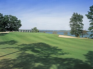
Santee is a town in Orangeburg County along the Santee River Valley in central South Carolina, United States. It has become a resort town of note located centrally north-south along the Atlantic Seaboard of South Carolina. The region has been rural, with a primarily agricultural economy typical of Orangeburg County, but is now known primarily for its several golf courses in proximity to Lake Marion, Santee State Park and other Lake Marion attractions. Interstate 95 connects its attractions easily with tourists traveling by automobile. I-95 crosses a narrow arm of the lake into the town lands, along a causeway. Lake Marion is a man-made hydroelectric reservoir, which at 110,000 acres is one of the fifty largest lakes in the country.

References

  1. 1 2 3 "QuickFacts: Marion County, South Carolina". United States Census Bureau. Retrieved March 22, 2024.
  2. "Find a County". National Association of Counties. Retrieved June 7, 2011.
  3. Gannett, Henry (1905). The Origin of Certain Place Names in the United States. U.S. Government Printing Office. p.  200.
  4. "2020 County Gazetteer Files – South Carolina". United States Census Bureau. August 23, 2022. Retrieved September 10, 2023.
  5. 1 2 3 "SCDNR Public Lands". www2.dnr.sc.gov. Retrieved April 1, 2023.
  6. "U.S. Decennial Census". United States Census Bureau. Retrieved March 18, 2015.
  7. "Historical Census Browser". University of Virginia Library. Retrieved March 18, 2015.
  8. Forstall, Richard L., ed. (March 27, 1995). "Population of Counties by Decennial Census: 1900 to 1990". United States Census Bureau. Retrieved March 18, 2015.
  9. "Census 2000 PHC-T-4. Ranking Tables for Counties: 1990 and 2000" (PDF). United States Census Bureau. April 2, 2001. Archived (PDF) from the original on October 9, 2022. Retrieved March 18, 2015.
  10. 1 2 "State & County QuickFacts". United States Census Bureau. Archived from the original on July 2, 2011. Retrieved November 25, 2013.
  11. "Explore Census Data". data.census.gov. Retrieved December 15, 2021.
  12. 1 2 3 "DP-1 Profile of General Population and Housing Characteristics: 2010 Demographic Profile Data". United States Census Bureau. Archived from the original on February 13, 2020. Retrieved March 11, 2016.
  13. "Population, Housing Units, Area, and Density: 2010 - County". United States Census Bureau. Archived from the original on February 13, 2020. Retrieved March 11, 2016.
  14. "DP02 SELECTED SOCIAL CHARACTERISTICS IN THE UNITED STATES – 2006-2010 American Community Survey 5-Year Estimates". United States Census Bureau. Archived from the original on February 13, 2020. Retrieved March 11, 2016.
  15. "DP03 SELECTED ECONOMIC CHARACTERISTICS – 2006-2010 American Community Survey 5-Year Estimates". United States Census Bureau. Archived from the original on February 13, 2020. Retrieved March 11, 2016.
  16. "U.S. Census website". United States Census Bureau . Retrieved May 14, 2011.
  17. Religious Congregations and Membership Study. "2010 Religious Census Data" (PDF). Association of Statisticians of American Religious Bodies. Archived (PDF) from the original on October 9, 2022. Retrieved May 7, 2012.
  18. Leip, David. "Dave Leip's Atlas of U.S. Presidential Elections". uselectionatlas.org. Retrieved March 13, 2018.
  19. U.S. Bureau of Economic Analysis (January 1, 2001). "Gross Domestic Product: All Industries in Marion County, SC". FRED, Federal Reserve Bank of St. Louis. Retrieved May 4, 2024.
  20. U.S. Bureau of Economic Analysis (January 1, 2001). "Real Gross Domestic Product: All Industries in Marion County, SC". FRED, Federal Reserve Bank of St. Louis. Retrieved May 4, 2024.
  21. 1 2 "Marion County" (PDF). Community Profiles (04000067). Columbia, SC: S.C. Department of Employment & Workforce - Business Intelligence Department. April 19, 2024.

Further reading