Saluda County, South Carolina

Last updated

Saluda County
Saluda Theatre (cropped).jpg
Saluda County Seal.png
Map of South Carolina highlighting Saluda County.svg
Location within the U.S. state of South Carolina
South Carolina in United States.svg
South Carolina's location within the U.S.
Coordinates: 34°01′N81°44′W / 34.01°N 81.73°W / 34.01; -81.73
CountryFlag of the United States.svg United States
StateFlag of South Carolina.svg  South Carolina
Founded1895
Named for Saluda River
Seat Saluda
Largest communitySaluda
Area
  Total461.64 sq mi (1,195.6 km2)
  Land452.72 sq mi (1,172.5 km2)
  Water8.92 sq mi (23.1 km2)  1.93%
Population
 (2020)
  Total18,862
  Estimate 
(2023)
19,123
  Density41.66/sq mi (16.09/km2)
Time zone UTC−5 (Eastern)
  Summer (DST) UTC−4 (EDT)
Congressional district 3rd
Website saludacounty.sc.gov

Saluda County is a county in the U.S. state of South Carolina. As of the 2020 census, the population was 18,862. [1] Its county seat is Saluda. [2] The county was formed from northern and eastern portions of Edgefield County. [3]

Contents

Saluda County is part of the Columbia, SC Metropolitan Statistical Area.

History

The county was founded in 1895 with portions of Edgefield County and was named after the nearby Saluda River. The largest community and county seat is Saluda.

Geography

Saluda County, South Carolina
Interactive map of Saluda County

According to the U.S. Census Bureau, the county has a total area of 461.64 square miles (1,195.6 km2), of which 452.72 square miles (1,172.5 km2) is land and 8.92 square miles (23.1 km2) (1.93%) is water. [4] Saluda County is largely in the Saluda River basin with a small portion of western Saluda in the Savannah River basin.

National protected area

Major water bodies

Adjacent Counties

Major highways

Major infrastructure

Demographics

Historical population
CensusPop.Note
1900 18,966
1910 20,94310.4%
1920 22,0885.5%
1930 18,148−17.8%
1940 17,192−5.3%
1950 15,924−7.4%
1960 14,554−8.6%
1970 14,528−0.2%
1980 16,15011.2%
1990 16,3571.3%
2000 19,18117.3%
2010 19,8753.6%
2020 18,862−5.1%
2023 (est.)19,123 [1] 1.4%
U.S. Decennial Census [6]
1790–1960 [7] 1900–1990 [8]
1990–2000 [9] 2010 [10] 2020 [1]

2020 census

Saluda County racial composition [11]
RaceNum.Perc.
White (non-Hispanic)11,26459.72%
Black or African American (non-Hispanic)4,02821.36%
Native American 440.23%
Asian 350.19%
Other/Mixed 4792.54%
Hispanic or Latino 3,01215.97%

As of the 2020 census, there were 18,862 people, 7,094 households, and 5,132 families residing in the county.

2010 census

At the 2010 census, there were 19,875 people, 7,527 households, and 5,393 families living in the county. [12] [10] The population density was 43.9 inhabitants per square mile (16.9/km2). There were 9,289 housing units at an average density of 20.5 per square mile (7.9/km2). [13] The racial makeup of the county was 61.1% white, 26.3% black or African American, 0.4% American Indian, 0.3% Pacific islander, 0.2% Asian, 10.3% from other races, and 1.4% from two or more races. Those of Hispanic or Latino origin made up 14.4% of the population. [12] In terms of ancestry, 17.8% were American, 14.7% were German, 8.6% were English, and 8.2% were Irish. [14]

Of the 7,527 households, 32.5% had children under the age of 18 living with them, 50.6% were married couples living together, 15.0% had a female householder with no husband present, 28.4% were non-families, and 24.2% of all households were made up of individuals. The average household size was 2.61 and the average family size was 3.05. The median age was 39.6 years. [12]

The median income for a household in the county was $40,508 and the median income for a family was $45,173. Males had a median income of $31,264 versus $28,344 for females. The per capita income for the county was $18,717. About 11.7% of families and 15.1% of the population were below the poverty line, including 19.4% of those under age 18 and 15.0% of those age 65 or over. [15]

2000 census

At the 2000 census, [16] there were 19,181 people, 7,127 households, and 5,295 families living in the county. The population density was 42 people per square mile (16 people/km2). There were 8,543 housing units at an average density of 19 per square mile (7.3/km2). The racial makeup of the county was 65.80% White, 29.99% Black or African American, 0.23% Native American, 0.04% Asian, 0.01% Pacific Islander, 3.29% from other races, and 0.64% from two or more races. 7.30% of the population were Hispanic or Latino of any race.

There were 7,127 households, out of which 31.80% had children under the age of 18 living with them, 54.20% were married couples living together, 14.50% had a female householder with no husband present, and 25.70% were non-families. 22.50% of all households were made up of individuals, and 10.40% had someone living alone who was 65 years of age or older. The average household size was 2.65 and the average family size was 3.07.

In the county, the population was spread out, with 24.90% under the age of 18, 9.20% from 18 to 24, 27.60% from 25 to 44, 23.80% from 45 to 64, and 14.50% who were 65 years of age or older. The median age was 37 years. For every 100 females there were 98.60 males. For every 100 females age 18 and over, there were 95.30 males.

The median income for a household in the county was $35,774, and the median income for a family was $41,603. Males had a median income of $29,221 versus $21,395 for females. The per capita income for the county was $16,328. About 12.00% of families and 15.60% of the population were below the poverty line, including 21.40% of those under age 18 and 16.30% of those age 65 or over.

Law and government

Law enforcement

In 2012, Saluda County Sheriff Jason Booth pled guilty to charges of misuse of office after using an inmate to make improvements at his home. [17]

Politics

United States presidential election results for Saluda County, South Carolina [18]
Year Republican Democratic Third party
No.%No.%No.%
2020 6,21066.96%2,96331.95%1011.09%
2016 5,52664.53%2,81332.85%2252.63%
2012 5,13559.96%3,32838.86%1011.18%
2008 5,19160.34%3,32338.63%891.03%
2004 4,53759.87%3,00139.60%400.53%
2000 4,09859.47%2,68238.92%1111.61%
1996 2,82549.56%2,48643.61%3896.82%
1992 2,96847.80%2,39338.54%84813.66%
1988 3,22561.64%1,98437.92%230.44%
1984 3,51563.90%1,96235.67%240.44%
1980 2,45047.40%2,65151.29%681.32%
1976 2,08543.09%2,71556.11%390.81%
1972 3,09573.85%1,02224.39%741.77%
1968 1,46630.53%1,20024.99%2,13644.48%
1964 2,52464.17%1,40935.83%00.00%
1960 1,26848.38%1,35351.62%00.00%
1956 34114.92%1,08047.24%86537.84%
1952 1,39646.72%1,59253.28%00.00%
1948 150.78%1879.77%1,71289.45%
1944 141.30%92485.56%14213.15%
1940 151.33%1,11598.67%00.00%
1936 100.75%1,32499.25%00.00%
1932 70.53%1,30799.47%00.00%
1928 50.62%79699.38%00.00%
1924 30.27%1,09499.55%20.18%
1920 30.27%1,11199.55%20.18%
1916 10.08%1,22799.51%50.41%
1912 00.00%85098.04%171.96%
1904 70.74%93899.26%00.00%
1900 70.55%1,26999.45%00.00%

Economy

In 2022, the GDP was $572.2 million (about $29,921 per capita), [19] and the real GDP was $495.6 million (about $25,918 per capita) in chained 2017 dollars. [20]

As of April 2024, some of the top employers of the county include Food Lion. [21]

Employment and Wage Statistics by Industry in Saluda County, South Carolina - Q3 2023 [21]
IndustryEmployment CountsEmployment Percentage (%)Average Annual Wage ($)
Accommodation and Food Services2084.614,872
Administrative and Support and Waste Management and Remediation Services420.937,076
Agriculture, Forestry, Fishing and Hunting4439.953,040
Arts, Entertainment, and Recreation621.426,208
Construction1363.044,980
Finance and Insurance481.158,448
Health Care and Social Assistance59113.239,780
Manufacturing1,92142.949,868
Other Services (except Public Administration)681.547,060
Professional, Scientific, and Technical Services1072.447,892
Public Administration3367.544,044
Real Estate and Rental and Leasing240.538,948
Retail Trade2956.628,652
Transportation and Warehousing671.554,912
Utilities330.769,680
Wholesale Trade962.152,572
Total4,477100.0%45,016

Communities

Towns

Unincorporated communities

Notable person

See also

Related Research Articles

<span class="mw-page-title-main">Newberry County, South Carolina</span> County in South Carolina, United States

Newberry County is a county located in the U.S. state of South Carolina. As of the 2020 census, its population was 37,719. Its county seat is Newberry. The name is of unknown origin, although one theory suggests that it was named by Quaker settlers in honor of their home of Newberry, a suburb of London in the United Kingdom.

<span class="mw-page-title-main">McCormick County, South Carolina</span> County in South Carolina, United States

McCormick County is a county located in the U.S. state of South Carolina. As of the 2020 census, its population was 9,526, making it the second-least populous county in South Carolina. Its county seat is McCormick. The county was formed in 1916 from parts of Edgefield, Abbeville, and Greenwood counties.

<span class="mw-page-title-main">Lexington County, South Carolina</span> County in South Carolina, United States

Lexington County is a county located in the U.S. state of South Carolina. As of the 2020 census, the population was 293,991. Its county seat and largest community is Lexington. The county was chartered in 1785 and was named in commemoration of Lexington, Massachusetts, the site of the Battle of Lexington in the American Revolutionary War. Lexington County is the sixth-most populous county in South Carolina by population and is part of the Columbia, SC Metropolitan Statistical Area. It is located in the Midlands region of South Carolina.

<span class="mw-page-title-main">Lee County, South Carolina</span> County in South Carolina, United States

Lee County is a county located in the U.S. state of South Carolina. As of the 2020 census, its population was 16,531, making it the fifth-least populous county in South Carolina. Its county seat is Bishopville.

<span class="mw-page-title-main">Hampton County, South Carolina</span> County in South Carolina, United States

Hampton County is a rural county located in the U.S. state of South Carolina. As of the 2020 census, the population was 18,561. Its county seat is Hampton. It was named for Confederate Civil War general Wade Hampton, who in the late 1870s, with the ending of Reconstruction, was elected as governor of South Carolina.

<span class="mw-page-title-main">Greenwood County, South Carolina</span> County in South Carolina, United States

Greenwood County is a county located in the U.S. state of South Carolina. As of the 2020 census, its population was 69,351. Its county seat is Greenwood.

<span class="mw-page-title-main">Edgefield County, South Carolina</span> County in South Carolina, United States

Edgefield County is a county located on the western border of the U.S. state of South Carolina. As of the 2020 census, its population was 25,657. Its county seat and largest community is Edgefield. The county was established on March 12, 1785.

<span class="mw-page-title-main">Dillon County, South Carolina</span> County in South Carolina, United States

Dillon County is a county located in the U.S. state of South Carolina. As of the 2020 census, the county's population was 28,292. The county seat is Dillon.

<span class="mw-page-title-main">Aiken County, South Carolina</span> County in South Carolina, United States

Aiken County is a county in the U.S. state of South Carolina. As of the 2020 census, its population was 168,808. Its county seat and largest community is Aiken. Aiken County is a part of the Augusta-Richmond County, GA-SC Metropolitan Statistical Area. It is mostly in the Sandhills region, with the northern parts reaching in the Piedmont and southern parts reaching into the Coastal Plain.

<span class="mw-page-title-main">Powdersville, South Carolina</span> CDP in South Carolina, United States

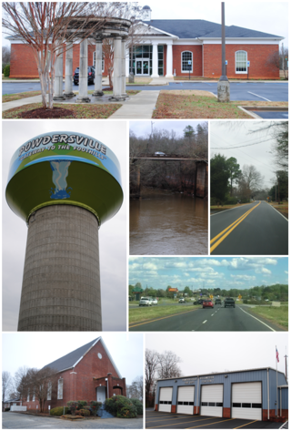
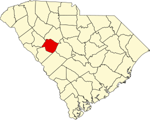
Powdersville is a census-designated place (CDP) in Anderson County, South Carolina. The population was 10,025 at the 2020 census,.

<span class="mw-page-title-main">Johnston, South Carolina</span> Town in South Carolina, United States

Johnston is a town in Edgefield County, South Carolina, United States. The population was 2,362 at the 2010 census. It is part of the Augusta, Georgia, metropolitan area. The town's official welcome sign states that it is "Peach Capital of the World".

<span class="mw-page-title-main">Murphys Estates, South Carolina</span> CDP in Edgefield County

Murphys Estates is a census-designated place (CDP) in Edgefield County, South Carolina, part of the larger Augusta metropolitan area. The population was 1,719 as of the 2020 census. The community is notable for having the largest number of Irish Travellers in the United States.

<span class="mw-page-title-main">Trenton, South Carolina</span> Town in South Carolina, United States

Trenton is a town in Edgefield County, South Carolina, United States. The population was 196 at the 2010 census, down from 226 in 2000.

<span class="mw-page-title-main">Watts Mills, South Carolina</span> Census-designated place in South Carolina, United States

Wattsville is an unincorporated community in Laurens County, South Carolina, United States. The town name is derived from Watts Mill, a textile mill in the center of town. The area is listed as the Wattsville census-designated place (CDP) for statistical purposes. The population of the CDP was 1,635 at the 2010 census. It is part of the Greenville–Mauldin–Easley Metropolitan Statistical Area.

<span class="mw-page-title-main">Modoc, South Carolina</span> CDP in South Carolina, United States

Modoc is a census-designated place (CDP) in McCormick County, South Carolina, United States. The population was 256 at the 2000 census, and 218 at the 2010 census, a decline of 14.8%.

<span class="mw-page-title-main">Ridge Spring, South Carolina</span> Town in South Carolina, United States

Ridge Spring is a town in Saluda County, South Carolina, United States. The population was 737 at the 2010 census. It is part of the Columbia, SC Metropolitan Statistical Area. The Mayor-Elect is Ms. Qwendolyn Etheredge.

<span class="mw-page-title-main">Saluda, South Carolina</span> Town in South Carolina, United States

Saluda is a town in Saluda County, South Carolina, United States, along the Little Saluda River. The population was 3,565 at the 2010 census. It is the county seat of Saluda County.

<span class="mw-page-title-main">Ward, South Carolina</span> Town in South Carolina, United States

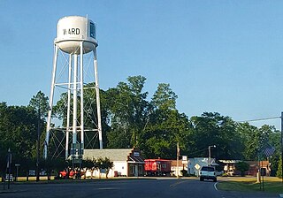
Ward is a town in Saluda County, South Carolina, United States. The population was 91 at the 2010 census.

<span class="mw-page-title-main">Monetta, South Carolina</span> Town in South Carolina, United States of America

Monetta is a town in Aiken and Saluda counties, South Carolina, United States. The population was 236 at the 2010 census.

<span class="mw-page-title-main">Piedmont, South Carolina</span> CDP in South Carolina, United States

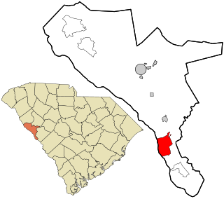
Piedmont is a census-designated place (CDP) along the Saluda River in Anderson and Greenville counties in the U.S. state of South Carolina. The population was 5,411 at the 2020 census.

References

  1. 1 2 3 "QuickFacts: Saluda County, South Carolina". United States Census Bureau. Retrieved March 22, 2024.
  2. "Find a County". National Association of Counties. Retrieved June 7, 2011.
  3. "South Carolina: Individual County Chronologies". South Carolina Atlas of Historical County Boundaries. The Newberry Library. 2009. Archived from the original on January 3, 2017. Retrieved March 21, 2015.
  4. "2020 County Gazetteer Files – South Carolina". United States Census Bureau. August 23, 2022. Retrieved September 10, 2023.
  5. "Airport". saludacounty.sc.gov. Retrieved August 5, 2022.
  6. "U.S. Decennial Census". United States Census Bureau. Retrieved March 19, 2015.
  7. "Historical Census Browser". University of Virginia Library. Retrieved March 19, 2015.
  8. Forstall, Richard L., ed. (March 27, 1995). "Population of Counties by Decennial Census: 1900 to 1990". United States Census Bureau. Retrieved March 19, 2015.
  9. "Census 2000 PHC-T-4. Ranking Tables for Counties: 1990 and 2000" (PDF). United States Census Bureau. April 2, 2001. Archived (PDF) from the original on October 9, 2022. Retrieved March 19, 2015.
  10. 1 2 "State & County QuickFacts". United States Census Bureau. Retrieved November 25, 2013.
  11. "Explore Census Data". data.census.gov. Retrieved December 15, 2021.
  12. 1 2 3 "DP-1 Profile of General Population and Housing Characteristics: 2010 Demographic Profile Data". United States Census Bureau. Archived from the original on February 13, 2020. Retrieved March 11, 2016.
  13. "Population, Housing Units, Area, and Density: 2010 - County". United States Census Bureau. Archived from the original on February 13, 2020. Retrieved March 11, 2016.
  14. "DP02 SELECTED SOCIAL CHARACTERISTICS IN THE UNITED STATES – 2006-2010 American Community Survey 5-Year Estimates". United States Census Bureau. Archived from the original on February 13, 2020. Retrieved March 11, 2016.
  15. "DP03 SELECTED ECONOMIC CHARACTERISTICS – 2006-2010 American Community Survey 5-Year Estimates". United States Census Bureau. Archived from the original on February 13, 2020. Retrieved March 11, 2016.
  16. "U.S. Census website". United States Census Bureau . Retrieved May 14, 2011.
  17. Jeffrey Collins (August 5, 2012). "Ex-Saluda sheriff pleads guilty to misconduct". Post and Courier. Retrieved November 9, 2021.
  18. Leip, David. "Dave Leip's Atlas of U.S. Presidential Elections". uselectionatlas.org.
  19. U.S. Bureau of Economic Analysis (January 1, 2001). "Gross Domestic Product: All Industries in Saluda County, SC". FRED, Federal Reserve Bank of St. Louis. Retrieved May 4, 2024.
  20. U.S. Bureau of Economic Analysis (January 1, 2001). "Real Gross Domestic Product: All Industries in Saluda County, SC". FRED, Federal Reserve Bank of St. Louis. Retrieved May 4, 2024.
  21. 1 2 "Saluda County" (PDF). Community Profiles (04000081). Columbia, SC: S.C. Department of Employment & Workforce - Business Intelligence Department. April 19, 2024.
  22. "Saluda County Historical Scoiety: Voices from Old Mount Willing". Archived from the original on February 23, 2009.
  23. "Mount Willing Populated Place Profile / Saluda County, South Carolina Data". southcarolina.hometownlocator.com.