
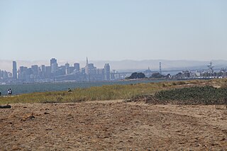
San Francisco, officially the City and County of San Francisco, is a commercial, financial, and cultural center of Northern California. The city proper is the fourth most populous in California, with 815,201 residents as of 2021, and covers a land area of 46.9 square miles, at the end of the San Francisco Peninsula, making it the second most densely populated large U.S. city after New York City and the fifth most densely populated U.S. county, behind only four of the five New York City boroughs. Among the 91 U.S. cities proper with over 250,000 residents, San Francisco was ranked first by per capita income and sixth by aggregate income as of 2021. Colloquial nicknames for San Francisco include SF, San Fran, The City, Frisco, and Baghdad by the Bay.

Hercules is a city in western Contra Costa County, California. Situated along the coast of San Pablo Bay, it is located in the eastern region of the San Francisco Bay Area, about 10 miles (16 km) north of Berkeley, California. As of 2010, its population was 24,060, according to the United States Census Bureau. The site of Hercules was first developed in 1881 as a manufacturing facility of the California Powder Works for the production of its patented dynamite formulation, Hercules powder. In 1882, the Hercules Powder Company was incorporated and assumed responsibility for the Hercules site. It was one of several explosive manufacturers that were active along the Pinole shoreline in the late 19th to the mid-20th century. The small company town that grew up near the facility subsequently became known as "Hercules", and was incorporated at the end of 1900. Starting in the 1970s, Hercules was heavily redeveloped as suburban bedroom community that lies along the I-80 corridor in Western Contra Costa County. It has a very ethnically diverse population.

Sausalito is a city in Marin County, California, United States, located 1.5 miles southeast of Marin City, 8 miles (13 km) south-southeast of San Rafael, and about 4 miles (6 km) north of San Francisco from the Golden Gate Bridge.
George Hargreaves is a landscape architect. Under his design direction, the work of his firm has received numerous national awards and has been published and exhibited nationally and internationally. He was an artist in residence at the American Academy of Rome in 2009. Hargreaves and his firm designed numerous sites including the master plan for the Sydney 2000 Olympics, The Brightwater Waste Water Treatment Facility in Seattle, Washington, and University of Cincinnati Master Plan.

Arthur Christ Agnos is an American politician. He served as the 39th mayor of San Francisco, California from 1988 to 1992 and as the Regional Head of the United States Department of Housing and Urban Development from 1993 to 2001.

The 1934 West Coast Waterfront Strike lasted 83 days, and began on May 9, 1934 when longshoremen in every US West Coast port walked out. Organized by the International Longshore and Warehouse Union (ILWU), the strike peaked with the death of two workers on "Bloody Thursday" and the San Francisco General Strike which stopped all work in the major port city for four days and led ultimately to the settlement of the West Coast Longshoremen's Strike.

The Embarcadero is the eastern waterfront and roadway of the Port of San Francisco, San Francisco, California, along San Francisco Bay. It was constructed on reclaimed land along a three mile long engineered seawall, from which piers extend into the bay. It derives its name from the Spanish verb embarcar, meaning "to embark"; embarcadero itself means "the place to embark." The Central Embarcadero Piers Historic District was added to the National Register of Historic Places on November 20, 2002.
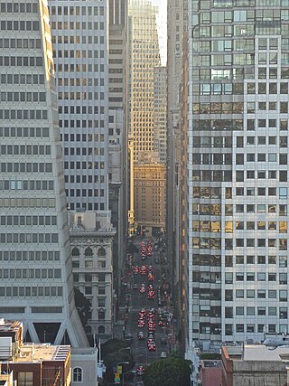
The Financial District is a neighborhood in San Francisco, California, United States, that serves as its main central business district and had 372,829 jobs according to U.S. census tracts as of 2012-2016. It is home to the city's largest concentration of corporate headquarters, law firms, insurance companies, real estate firms, savings and loan banks, and other financial institutions. Multiple Fortune 500 companies headquartered in San Francisco have their offices in the Financial District, including Wells Fargo, Salesforce, PG&E, Uber, Gap, and Williams-Sonoma.
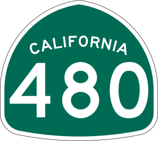
State Route 480 was a state highway in San Francisco, California, United States, consisting of the elevated double-decker Embarcadero Freeway, the partly elevated Doyle Drive approach to the Golden Gate Bridge and the proposed and unbuilt section in between. The unbuilt section from Doyle Drive to Van Ness Avenue was to have been called the Golden Gate Freeway and the Embarcadero Freeway as originally planned would have extended from Van Ness along the north side of Bay Street and then along the Embarcadero to the San Francisco-Oakland Bay Bridge.

The San Francisco Belt Railroad was a short-line railroad along the Embarcadero in San Francisco, California. It began as the State Belt Railroad in 1889, and was renamed when the city bought the Port of San Francisco in 1969. As a state owned enterprise, the railroad asserted several unsuccessful claims to immunity from federal regulation. The railroad ceased operation in 1993.
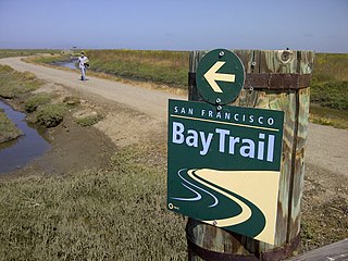
The San Francisco Bay Trail is a bicycle and pedestrian trail that when finished will allow continuous travel around the shoreline of San Francisco Bay. As of 2020, 356 miles (573 km) of the trail have been completed. When finished, the trail will be over 500 miles (800 km) of paved and gravel paths, bike lanes, and sidewalks, linking 47 cities across nine counties and crossing seven toll bridges. It is a project of the Association of Bay Area Governments (ABAG) and the Metropolitan Transportation Commission (MTC), in collaboration with other agencies, private companies, non-profit organizations, and advocacy groups.

The Port of San Francisco is a semi-independent organization that oversees the port facilities at San Francisco, California, United States. It is run by a five-member commission, appointed by the Mayor and approved by the Board of Supervisors. The Port is responsible for managing the larger waterfront area that extends from the anchorage of the Golden Gate Bridge, along the Marina district, all the way around the north and east shores of the city of San Francisco including Fisherman's Wharf and the Embarcadero, and southward to the city line just beyond Candlestick Point. In 1968 the State of California, via the California State Lands Commission for the State-operated San Francisco Port Authority, transferred its responsibilities for the Harbor of San Francisco waterfront to the City and County of San Francisco / San Francisco Harbor Commission through the Burton Act AB2649. All eligible State port authority employees had the option to become employees of the City and County of San Francisco to maintain consistent operation of the Port of San Francisco.

The Berkeley Marina is the westernmost portion of the city of Berkeley, California, located west of the Eastshore Freeway at the foot of University Avenue on San Francisco Bay. Narrowly speaking, "Berkeley Marina" refers only to the city marina, but in common usage, it applies more generally to the surrounding area.
India Basin is neighborhood in the southeastern part of San Francisco, California, considered to be part of the larger Bayview–Hunters Point neighborhood.

Aquatic Park Historic District is a National Historic Landmark and building complex on the San Francisco Bay waterfront within San Francisco Maritime National Historical Park.

The Central Embarcadero Piers Historic District is a Registered Historic District in the city of San Francisco, California, United States. It consists of Piers 1, 1½, 3 and 5, which form one of the largest surviving pier complexes along San Francisco's Embarcadero waterfront road. It was added to the National Register of Historic Places in 2002.
Crown Memorial State Beach is a state park in the city of Alameda, California on the shores of San Francisco Bay. It is operated by East Bay Regional Parks District (EBRPD), under a cooperative agreement with the State of California and the City of Alameda.
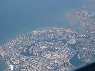
The Foster City Marina is a planned facility for waterfront land use and boat berthing in Foster City, California. The site area is 60 acres (24 ha) and the marina site is the only land use designated as "waterfront commercial" by the city's General Plan. The original formal planning for the Foster City Marina began in the mid 1980s when the city council authorized Earth Metrics Inc to prepare an Environmental Impact Report for the marina use. The marina is designed to provide berthing for 750 vessels, and this site has been the focus of considerable political debate as to the timing of development.
Citizens for East Shore Parks (CESP) is a United States environmental organization that focuses on the acquisition and preservation of parkland in the San Francisco Bay Area. CESP works to protect open space along the East Bay shoreline for natural habitat and recreational purposes through a combination of advocacy, education, and outreach. Since its founding in 1985, CESP has worked to secure approximately 1,800 acres (730 ha) of public land, primarily through the creation of the 8.5-mile (13.7 km) long Eastshore State Park in 2002.

The 2014 San Francisco Board of Supervisors elections occurred on November 4, 2014. Five of the eleven seats of the San Francisco Board of Supervisors were contested in this election. Incumbents in all five districts successfully ran for re-election.

