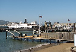
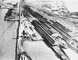
The Hyde Street Pier, at 2905 Hyde Street, is a historic ferry pier located on the northern waterfront of San Francisco in the U.S. state of California. [1]
The Hyde Street Pier, at 2905 Hyde Street, is a historic ferry pier located on the northern waterfront of San Francisco in the U.S. state of California. [1]
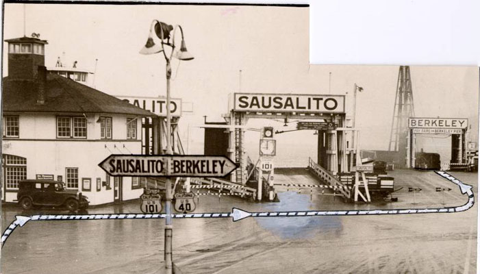
Prior to the opening of the Golden Gate Bridge and the San Francisco–Oakland Bay Bridge, it was the principal automobile ferry terminal connecting San Francisco with Marin County by way of Sausalito to the north, and the East Bay by way of Berkeley. It was designated part of U.S. Route 101 and U.S. Route 40. The ferries began operation by the Golden Gate Ferry Company. In early-1929, the Golden Gate Ferry Company merged with the competing auto ferry system of the Southern Pacific railroad, with ferry service to the Hyde Street Pier taken over by the new "Southern Pacific-Golden Gate Ferries, Ltd." starting on May 1, 1929. [2]
The pier is part of the San Francisco Maritime National Historical Park. Various historical ships are moored to the pier, some available for self-guided or docent-led tours. Among the ships on display or in storage are the Balclutha , an 1886 square rigged sailing ship, as well as C.A. Thayer , Eureka , Alma , Hercules , Eppleton Hall , and over one hundred smaller craft. In 2023, the Hōkūleʻa, a Polynesian double-hulled voyaging canoe, docked here as part of its Moananuiakea voyage, the circumnavigation of the Pacific Ocean. [3]

The Golden Gate Bridge is a suspension bridge spanning the Golden Gate, the one-mile-wide (1.6 km) strait connecting San Francisco Bay and the Pacific Ocean. The structure links the U.S. city of San Francisco, California—the northern tip of the San Francisco Peninsula—to Marin County, carrying both U.S. Route 101 and California State Route 1 across the strait. It also carries pedestrian and bicycle traffic, and is designated as part of U.S. Bicycle Route 95. Recognized by the American Society of Civil Engineers as one of the Wonders of the Modern World, the bridge is one of the most internationally recognized symbols of San Francisco and California.
The Key System was a privately owned company that provided mass transit in the cities of Oakland, Berkeley, Alameda, Emeryville, Piedmont, San Leandro, Richmond, Albany, and El Cerrito in the eastern San Francisco Bay Area from 1903 until 1960, when it was sold to a newly formed public agency, AC Transit. The Key System consisted of local streetcar and bus lines in the East Bay, and commuter rail and bus lines connecting the East Bay to San Francisco by a ferry pier on San Francisco Bay, later via the lower deck of the Bay Bridge. At its height during the 1940s, the Key System had over 66 miles (106 km) of track. The local streetcars were discontinued in 1948 and the commuter trains to San Francisco were discontinued in 1958. The Key System's territory is today served by BART and AC Transit bus service.

Eureka is a side-wheel paddle steamboat, built in 1890, which is now preserved at the San Francisco Maritime National Historical Park in San Francisco, California. Originally named Ukiah to commemorate the railway's recent extension into the City of Ukiah, the boat was built by the San Francisco and North Pacific Railroad Company at their Tiburon yard. Eureka has been designated a National Historic Landmark and was listed in the National Register of Historic Places on April 24, 1973.
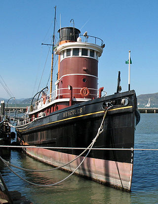
Hercules is a 1907-built steam tugboat that is now preserved at the San Francisco Maritime National Historical Park in San Francisco, California.
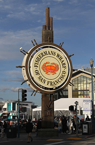
Fisherman's Wharf is a neighborhood and popular tourist attraction in San Francisco, California, United States. It roughly encompasses the northern waterfront area of San Francisco from Ghirardelli Square or Van Ness Avenue east to Pier 35 or Kearny Street. The F Market streetcar runs through the area, the Powell-Hyde cable car line runs to Aquatic Park, at the edge of Fisherman's Wharf, and the Powell-Mason cable car line runs a few blocks away.
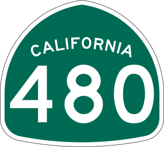
State Route 480 was a state highway in San Francisco, California, United States, consisting of the elevated double-decker Embarcadero Freeway, the partly elevated Doyle Drive approach to the Golden Gate Bridge and the proposed and unbuilt section in between. The unbuilt section from Doyle Drive to Van Ness Avenue was to have been called the Golden Gate Freeway and the Embarcadero Freeway as originally planned would have extended from Van Ness along the north side of Bay Street and then along the Embarcadero to the San Francisco-Oakland Bay Bridge.

The San Francisco Ferry Building is a terminal for ferries that travel across the San Francisco Bay, a food hall and an office building. It is located on The Embarcadero in San Francisco, California and is served by Golden Gate Ferry and San Francisco Bay Ferry routes.

The Berkeley Pier is in Berkeley, California. When constructed in 1926, the pier extended 3.5 miles (5.6 km) into San Francisco Bay from the end of University Avenue. Due to extensive filling of the bay and the creation of the Berkeley Marina, it presently extends only 2.5 miles (4.0 km). Since 1937, only the first 3,000 feet (910 m) were maintained and open to the public until July 2015, when public access was closed due to safety concerns.

People in the San Francisco Bay Area rely on a complex multimodal transportation infrastructure consisting of roads, bridges, highways, rail, tunnels, airports, seaports, and bike and pedestrian paths. The development, maintenance, and operation of these different modes of transportation are overseen by various agencies, including the California Department of Transportation (Caltrans), the Association of Bay Area Governments, San Francisco Municipal Transportation Agency, and the Metropolitan Transportation Commission. These and other organizations collectively manage several interstate highways and state routes, eight passenger rail networks, eight trans-bay bridges, transbay ferry service, local and transbay bus service, three international airports, and an extensive network of roads, tunnels, and bike paths.

The Port of San Francisco is a semi-independent organization that oversees the port facilities at San Francisco, California, United States. It is run by a five-member commission, appointed by the Mayor and approved by the Board of Supervisors. The Port is responsible for managing the larger waterfront area that extends from the anchorage of the Golden Gate Bridge, along the Marina district, all the way around the north and east shores of the city of San Francisco including Fisherman's Wharf and the Embarcadero, and southward to the city line just beyond Candlestick Point. In 1968, the State of California, via the California State Lands Commission for the State-operated San Francisco Port Authority, transferred its responsibilities for the Harbor of San Francisco waterfront to the City and County of San Francisco / San Francisco Harbor Commission through the Burton Act AB2649. All eligible State port authority employees had the option to become employees of the City and County of San Francisco to maintain consistent operation of the Port of San Francisco.

The Berkeley Marina is the westernmost portion of the city of Berkeley, California, located west of the Eastshore Freeway at the foot of University Avenue on San Francisco Bay. Narrowly speaking, "Berkeley Marina" refers only to the city marina, but in common usage, it applies more generally to the surrounding area.
The Oakland Long Wharf was an 11,000-foot railroad wharf and ferry pier along the east shore of San Francisco Bay located at the foot of Seventh Street in West Oakland. The Oakland Long Wharf was built, beginning 1868, by the Central Pacific Railroad on what was previously Oakland Point. Beginning November 8, 1869, it served as the west coast terminus of the First transcontinental railroad. In the 1880s, Southern Pacific Railroad took over the CPRR, extending it and creating a new ferry terminal building with the official station name Oakland Pier. The entire structure became commonly and popularly called the Oakland Mole. Portions of the Wharf lasted until the 1960s. The site is now part of the facilities of the Port of Oakland, while passenger train service operates at the nearby Jack London Square/Dellums Station and another nearby station in Emeryville.

Aquatic Park Historic District is a National Historic Landmark and building complex on the San Francisco Bay waterfront within San Francisco Maritime National Historical Park.

San Francisco Bay in California has been served by ferries of all types for over 150 years. John Reed established a sailboat ferry service in 1826. Although the construction of the Golden Gate Bridge and the San Francisco–Oakland Bay Bridge led to the decline in the importance of most ferries, some are still in use today for both commuters and tourists.
Golden Gate Ferry is a commuter ferry service operated by the Golden Gate Bridge, Highway and Transportation District in San Francisco Bay, part of the Bay Area of Northern California, United States. Regular service is run to the Ferry Building in San Francisco from Larkspur, Sausalito, Tiburon, and Angel Island in Marin County, with additional service from Larkspur to Oracle Park and Chase Center. The ferry service is funded primarily by passenger fares and Golden Gate Bridge tolls. In 2022, Golden Gate Ferry had a ridership of 1,022,800, or about 4,200 per weekday as of the second quarter of 2023.
The General Frank M. Coxe was a steam ferry which was built for the United States Army to provide transportation services among several military facilities that ring California's San Francisco Bay. The Army port facilities, including the vessels, throughout the bay were under the command of the San Francisco Port of Embarkation from its establishment in May 1932 through World War II and the Korean War.

Asbury Park was a high-speed coastal steamer built in Philadelphia, and intended to transport well-to-do persons from New York to summer homes on the New Jersey shore. This vessel was sold to West Coast interests in 1918, and later converted to an automobile ferry, serving on various routes San Francisco Bay, Puget Sound and British Columbia. This vessel was known by a number of other names, including City of Sacramento, Kahloke, Langdale Queen, and Lady Grace.

The Richmond–San Rafael Ferry Company was a ferry service between Castro Point in Richmond in Contra Costa County and San Quentin in Marin County, California across the San Pablo Bay. It ran from 1915 until the 1956 opening of the Richmond–San Rafael Bridge.

Golden Gate Ferry Company was a private company which operated automobile ferries between San Francisco, Berkeley and Sausalito before the opening of the Bay Bridge and the Golden Gate Bridge. The company was incorporated in November 1920. The ferry went bankrupt at the completion of the Golden Gate Bridge, but with the start of World War 2 the demand for service was so great it started again. Ferry service started just one year after closing to ferry shipyard workers to the Marinship and Kaiser Shipyards shipyard in San Francisco. But after the war, service was discontinued again. In early 1929, the Golden Gate Ferry Company merged with the ferry system of the Southern Pacific railroad, becoming the Southern Pacific-Golden Gate Ferries, Ltd.
37°48′32″N122°25′16″W / 37.80897°N 122.42117°W
| Culture | |
|---|---|
| Geography | |
| Public art | |
| Transportation | |