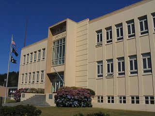
Curry County is the southwesternmost county in the U.S. state of Oregon located on the South Coast. As of the 2020 census, the population was 23,446. The county seat is Gold Beach. The county is named for George Law Curry, a two-time governor of the Oregon Territory. Curry County includes the Brookings, OR Micropolitan Statistical Area.

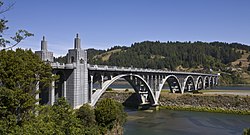
Gold Beach is a city in and the county seat of Curry County, Oregon, United States, on the Oregon Coast. The population was 2,241 at the 2020 census.

Sweet Home is a city in Linn County, Oregon, United States, with a population of 8,925 at the 2010 census. Built near the site of a prehistoric petrified forest, Sweet Home experienced substantial growth during the construction of the Green Peter and Foster dams in the 1940s. The town's main attraction nowadays is the Cascade mountains through Santiam Pass.

The Rogue River in southwestern Oregon in the United States flows about 215 miles (346 km) in a generally westward direction from the Cascade Range to the Pacific Ocean. Known for its salmon runs, whitewater rafting, and rugged scenery, it was one of the original eight rivers named in the Wild and Scenic Rivers Act of 1968. Beginning near Crater Lake, which occupies the caldera left by the explosive volcanic eruption and collapse of Mount Mazama, the river flows through the geologically young High Cascades and the older Western Cascades, another volcanic province. Further west, the river passes through multiple exotic terranes of the more ancient Klamath Mountains. In the Kalmiopsis Wilderness section of the Rogue basin are some of the world's best examples of rocks that form the Earth's mantle. Near the mouth of the river, the only dinosaur fragments ever discovered in Oregon were found in the Otter Point Formation, along the coast of Curry County.
Agness is an unincorporated community in Curry County, Oregon, United States. It is near the confluence of two Wild and Scenic rivers—the Lower Rogue and the Illinois. Agness post office was established October 16, 1897. It was named after Agnes, the daughter of the first postmaster, and subsequently misspelled. The Agness area is popular for fishing and hiking. Agness is in the Rogue River–Siskiyou National Forest and was threatened by the Biscuit Fire in 2002.

Prospect is an unincorporated community and census-designated place (CDP) in Jackson County, in the U.S. state of Oregon. It lies along Oregon Route 62 on the Rogue River, in the Rogue River – Siskiyou National Forest. As of the 2010 census it had a population of 455.

Silver Lake is an unincorporated community and census-designated place in western Lake County, Oregon, United States, along Oregon Route 31. As of the 2010 census, it had a population of 149. Facilities include a gas station and a small store, a post office, and a public school, North Lake School, serving grades K-12.

Alsea is an unincorporated community in Benton County, in the U.S. state of Oregon. It is on Oregon Route 34 and the Alsea River. For statistical purposes, the United States Census Bureau has defined Alsea as a census-designated place (CDP). The census definition of the area may not precisely correspond to local understanding of the area with the same name. As of the 2020 Census, the population was 165.
Pistol River is an unincorporated community and census-designated place in Curry County, Oregon, United States. As of the 2010 census it had a population of 84. It is near the Pistol River and the Pistol River State Scenic Viewpoint, just to the east of U.S. Route 101.

Days Creek is an unincorporated community and census-designated place in Douglas County, Oregon, United States. At the 2010 census it had a population of 272.

Ruch is an unincorporated community and census-designated place (CDP) in Jackson County, Oregon, United States. It is located on Oregon Route 238, southeast of Grants Pass. As of the 2010 census, it had a population of 840.
Kerby is an unincorporated community and census-designated place (CDP) in Josephine County, Oregon, United States, north of Cave Junction on U.S. Route 199. As of the 2010 census the population was 595. Despite its population and numerous businesses, it is often listed in tourist guides as a ghost town, because of the number of historic buildings left from its days as a gold-mining town. Kerby came into existence between 1854 and 1857.

The history of steamboats on the Oregon Coast begins in the late 19th century. Before the development of modern road and rail networks, transportation on the coast of Oregon was largely water-borne. This article focuses on inland steamboats and similar craft operating in, from south to north on the coast: Rogue River, Coquille River, Coos Bay, Umpqua River, Siuslaw Bay, Yaquina Bay, Siletz River, and Tillamook Bay. The boats were all very small, nothing like the big sternwheelers and propeller boats that ran on the Columbia River or Puget Sound. There were many of them, however, and they came to be known as the "mosquito fleet."

The Mary D. Hume was a steamer built at Gold Beach, Oregon in 1881, by R. D. Hume, a pioneer and early businessman in that area. Gold Beach was then called Ellensburg. The Hume had a long career, first hauling goods between Oregon and San Francisco, then as a whaler in Alaska, as a service vessel in the Alaskan cannery trade, then as a tugboat. She was retired in 1977 and returned to Gold Beach. In 1985 she sank in the Rogue River and has remained there ever since as a derelict vessel on the shoreline. The Hume is listed on the National Register of Historic Places.

Nesika Beach is census-designated place and unincorporated community in Curry County, Oregon, United States. It is located 8 miles (13 km) north of Gold Beach on the Oregon Coast. As of the 2020 census it had a population of 432.

Williams is an unincorporated community and census-designated place (CDP) in Josephine County, Oregon, United States. As of the 2010 census it had a population of 1,072.
Central Curry School District 1 (CCSD) is a public school district headquartered in Gold Beach in Curry County, Oregon, United States.

Gold Beach High School is a public high school in Gold Beach, Oregon, United States. It is a part of the Central Curry School District.

Robert Deniston Hume was a cannery owner, pioneer hatchery operator, politician, author, and self-described "pygmy monopolist" who controlled salmon fishing for 32 years on the lower Rogue River in U.S. state of Oregon. Born in Augusta, Maine, and reared by foster parents on a farm, Hume moved at age 18 to San Francisco to join a salmon-canning business started by two of his brothers. They later re-located to Astoria on the Columbia River, where they prospered. After the death of his first wife and their two young children, Hume moved again and started anew in Gold Beach, at the mouth of the Rogue.
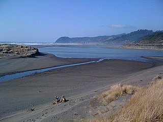
The Pistol River is a coastal stream that meanders for 21 miles (34 km) through the Southern Oregon Coast Range to the Pacific Ocean near the unincorporated community of Pistol River in the U.S. state of Oregon. Flowing generally southwest from its origin near Sugarloaf Mountain in the Siskiyou National Forest, the river enters the sea at Pistol River State Scenic Viewpoint, 10 miles (16 km) south of Gold Beach. The river received its name after pioneer James Mace lost his pistol in it in 1853.