
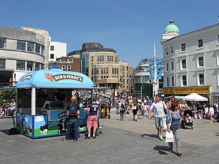
Brighton is a seaside resort and one of the two main areas of the city of Brighton and Hove in the county of East Sussex, England. It is located 47 mi (76 km) south of London. Archaeological evidence of settlement in the area dates back to the Bronze Age, Roman and Anglo-Saxon periods. The ancient settlement of "Brighthelmstone" was documented in the Domesday Book (1086). The town's importance grew in the Middle Ages as the Old Town developed, but it languished in the early modern period, affected by foreign attacks, storms, a suffering economy and a declining population. Brighton began to attract more visitors following improved road transport to London and becoming a boarding point for boats travelling to France. The town also developed in popularity as a health resort for sea bathing as a purported cure for illnesses.

Hove is a seaside resort. It is one of the two main parts of the city of Brighton and Hove, in East Sussex, England.
Brighton and Hove is unitary authority with city status in East Sussex, England. There are multiple villages alongside the seaside resorts of Brighton and Hove in the district. It is administered by Brighton and Hove City Council, which is currently under Labour majority control.
Portslade is a western suburb of the city of Brighton and Hove in the ceremonial county of East Sussex, England. Portslade Village, the original settlement a mile inland to the north, was built up in the 16th century. The arrival of the railway from Brighton in 1840 encouraged rapid development of the coastal area and in 1898 the southern part, formerly known as Copperas Gap, was granted urban district status and renamed Portslade-by-Sea, making it distinct from Portslade Village. After World War II the district of Mile Oak to the north was added. Today, Portslade is bisected from east to west by the old A27 road between Brighton and Worthing, each part having a distinct character.

Preston or Preston Village is a suburb of the unparished area of Brighton and Hove, in the ceremonial county of East Sussex, England. It is to the north of the centre. Originally a village in its own right, it was eventually absorbed into Brighton with the development of the farmland owned by the local Stanford family, officially becoming a parish of the town in 1928. Stanford-owned land to the south of Preston Manor was given to the town and now makes up Preston Park, one of the largest parks in the now conjoined city of Brighton and Hove. The park hosts some of the city's major public events such as Brighton Pride.

East Blatchington is a coastal village in East Sussex which has merged into the western part of Seaford, contiguous with Bishopstone, in the civil parish of Seaford, in the Lewes district, in the county of East Sussex, England. It is located near the abandoned village of Tide Mills.

Hangleton is a residential suburb and unparished area of Brighton and Hove, in the ceremonial county of East Sussex, England. The area was developed in the 1930s after it was incorporated into the borough of Hove, but has ancient origins: its parish church was founded in the 11th century and retains 12th-century fabric, and the medieval manor house is Hove's oldest secular building. The village became depopulated in the medieval era and the church fell into ruins, and the population in the isolated hilltop parish only reached 100 in the early 20th century; but rapid 20th-century development resulted in more than 6,000 people living in Hangleton in 1951 and over 9,000 in 1961. By 2013 the population exceeded 14,000.
Ovingdean is a small, formerly agricultural village and former civil parish on the eastern edge of the city of Brighton and Hove in the ceremonial county East Sussex, England. In 1921 the parish had a population of 476. On 1 April 1928 the parish was abolished and merged with Brighton.

Mile Oak is a locality forming the northern part of the former parish of Portslade in the northwest corner of the city of Brighton and Hove, England. Now mostly residential, but originally an area of good-quality agricultural land, it covers the area north of Portslade village as far as the urban boundary.

Patcham is a suburb of Brighton in the city of Brighton and Hove, in the ceremonial county of East Sussex, England. It is about 3 miles (5 km) north of the city centre. It is bounded by the A27 to the north, Hollingbury to the east and southeast, Withdean to the south and the Brighton Main Line to the west. The A23 passes through the area.
Blatchington Mill School is a coeducational secondary school in Hove, Brighton and Hove for 11 to 16-year-olds.

Aldrington is an area of Hove, in the city of Brighton and Hove in the ceremonial county of East Sussex, England. It was formerly a civil parish. For centuries it was meadow land along the English Channel stretching west from the old village of Hove to the old mouth of the River Adur, and it is now a prosperous residential area integrated within Hove.

West Blatchington Windmill is a Grade II* listed smock mill at West Blatchington, Brighton and Hove, in the historic county of Sussex, England which has been restored and is open to the public.

St Peter's Church is an Anglican church in the West Blatchington area of Hove, part of the English city of Brighton and Hove. Although it has 11th- and 12th-century origins, the church was rebuilt from a ruined state in the late 19th century and extended substantially in the 1960s, and little trace remains of the ancient building. The church serves the parish of West Blatchington, a residential area in the north of Hove near the border with Brighton.

Holy Trinity Church is a former Anglican church in Hove, in the English city of Brighton and Hove. Built in the early 1860s to provide extra capacity for Anglican worshippers in the rapidly growing town of Hove, its use declined in the 20th century and it was closed in 2007 following a Diocesan review. Until 2015—when a planning application to convert the building into a doctors surgery was approved—its future was uncertain, and a heritage group has described it as one of Britain's top ten threatened Victorian and Edwardian buildings. The church, which has been a medical centre since 2017, has Grade II listed status, reflecting its architectural and historic importance.

St Peter's Church is a Roman Catholic church in the Aldrington area of Hove, part of the English city of Brighton and Hove. It is one of three Roman Catholic churches in Hove and one of eleven in the wider city area. Built between 1912 and 1915 in a red-brick Romanesque style, its tall campanile forms a local landmark. It has been listed at Grade II by English Heritage in view of its architectural importance.

Westdene is an area of the city of Brighton and Hove, East Sussex. It is an affluent northern suburb of the city, west of Patcham, the A23 and the London to Brighton railway line, north of Withdean and northeast of West Blatchington. It is on the Brighton side of the historic parish boundary between Brighton and Hove and is served by Preston Park railway station. It is known for its greenery and woodland and is very close to the South Downs, from which it is separated by the Brighton Bypass, and was built on the slopes of two hills.

The British Engineerium is an engineering and steam power museum in Hove, East Sussex. It is housed in the Goldstone Pumping Station, a set of High Victorian Gothic buildings started in 1866. The Goldstone Pumping Station supplied water to the local area for more than a century before it was converted to its present use. The site has been closed to the public since 2006, and in March 2018 the entire complex was put up for sale.

The English coastal city of Brighton and Hove, made up of the formerly separate Boroughs of Brighton and Hove in East Sussex, has a wide range of cemeteries throughout its urban area. Many were established in the mid-19th century, a time in which the Victorian "cult of death" encouraged extravagant, expensive memorials set in carefully cultivated landscapes which were even recommended as tourist attractions. Some of the largest, such as the Extra Mural Cemetery and the Brighton and Preston Cemetery, were set in particularly impressive natural landscapes. Brighton and Hove City Council, the local authority responsible for public services in the city, manages seven cemeteries, one of which also has the city's main crematorium. An eighth cemetery and a second crematorium are owned by a private company. Many cemeteries are full and no longer accept new burials. The council maintains administrative offices and a mortuary at the Woodvale Cemetery, and employs a coroner and support staff.

