
East Sussex is a county in South East England. It is bordered by the counties of Kent to the north and east, West Sussex to the west, and Surrey for a short distance to the north-west, as well as the English Channel to the south.

St Leonard's Church is an Anglican church in Hove, in the English city of Brighton and Hove. It is on New Church Road in the Aldrington area of Hove, which was previously a separate village, and it serves as Aldrington's parish church. The church was on Church Road but now stands on New Church Road, renamed in reference to the other church which was started in 1894 as a chapel of ease.

The London Road Viaduct is a brick railway viaduct in Brighton, part of the city of Brighton and Hove in East Sussex, England. It carries the East Coastway Line between Brighton and London Road railway stations. Built in the 1840s for the Brighton, Lewes and Hastings Railway by the locomotive engineer and railway architect John Urpeth Rastrick, the sharply curving structure has 27 arches and about 10 million bricks. It is still in constant use, and is listed at Grade II* for its historical and architectural significance.
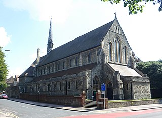
St John the Evangelist's Church is an Anglican church in the Preston Village area of Brighton, in the English city of Brighton and Hove. The Grade II listed building, designed by Sir Arthur Blomfield, was started in 1901 but did not take its present form for another quarter of a century. In the meantime, the nearby parish church of Preston was severely damaged by fire, and the new church was granted the parish church status which it still retains.

Westdene is an area of the city of Brighton and Hove, East Sussex. It is an affluent northern suburb of the city, west of Patcham, the A23 and the London to Brighton railway line, north of Withdean and northeast of West Blatchington. It is on the Brighton side of the historic parish boundary between Brighton and Hove and is served by Preston Park railway station. It is known for its greenery and woodland and is very close to the South Downs, from which it is separated by the Brighton Bypass, and was built on the slopes of two hills.

St Augustine's Church is a former Anglican church in Brighton, part of the English city of Brighton and Hove. It is close to the Preston Park and Round Hill areas in the central northern part of the city. Built in 1896 and extended in 1914, its parish was extended after a nearby church closed, but in 2003 it was declared redundant itself. The building, which is listed at Grade II in view of its architectural importance, has stood empty since then, apart from a few years from 2004 when the building was leased by the Elim Pentecostal Church. The Pentecostal congregation made free-standing internal changes to create internal spaces which could be heated in winter, but did not touch the fabric of the building.

There are 72 Grade II* listed buildings in the city of Brighton and Hove, England. The city, on the English Channel coast approximately 52 miles (84 km) south of London, was formed as a unitary authority in 1997 by the merger of the neighbouring towns of Brighton and Hove. Queen Elizabeth II granted city status in 2000.
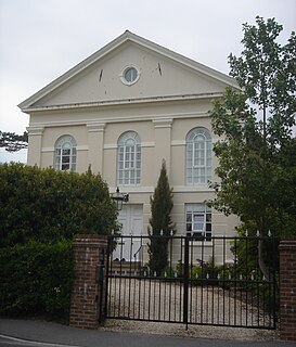
Providence Strict Baptist Chapel is a former Strict Baptist place of worship in the town of Burgess Hill in Mid Sussex, one of seven local government districts in the English county of West Sussex. Founded in 1875 by two prominent residents of the town at a time when Protestant Nonconformism was well established in Sussex, the chapel continued in religious use for over a century until it was sold for conversion to a family home in 1999. The Neoclassical building stands in a conservation area opposite Burgess Hill's main park. English Heritage has listed the building at Grade II for its architectural and historical importance.

Carlton Hill is an inner-city area of Brighton, part of the English city and seaside resort of Brighton and Hove. First developed in the early and mid-19th century on steeply sloping farmland east of central Brighton, it grew rapidly as the town became a fashionable, high-class destination. Carlton Hill's population was always poor, though, and by the early 20th century the area was Brighton's worst slum: overcrowding, crime and disease were rife. Extensive slum clearance in the mid-20th century introduced high-density tower blocks, but some old buildings remain: in 2008, Brighton and Hove City Council designated part of Carlton Hill as the city's 34th conservation area. The area now has housing of various styles and ages, large offices and small-scale industry; there are also churches, a school and some open space.

Round Hill is an inner suburban area of Brighton, part of the coastal city of Brighton and Hove in England. The area contains a mix of privately owned and privately rented terraced housing, much of which has been converted for multiple occupancies, and small-scale commercial development. It was developed mostly in the late 19th century on an area of high land overlooking central Brighton and with good views in all directions, the area became a desirable middle-class suburb—particularly the large terraced houses of Roundhill Crescent and Richmond Road, and the exclusive Park Crescent—and within a few decades the whole of the hill had been built up with smaller terraces and some large villas.
Roundhill Crescent is a late-19th-century housing development in Round Hill, an inner suburb of the English coastal city of Brighton and Hove. Partly developed in the 1860s with large terraced houses on a steeply sloping open hillside, the crescent—which "curves and changes height dramatically along its length"—was finished two decades later and now forms the centrepiece of the Round Hill conservation area. Smaller houses completed the composition in the 1880s, and England's first hospital for the treatment of mental illness was founded in the crescent in 1905. The five original sets of houses from the 1860s have been listed at Grade II by English Heritage for their architectural and historical importance, and the crescent occupies a prominent place on Brighton's skyline.

Montpelier is an inner suburban area of Brighton, part of the English city and seaside resort of Brighton and Hove. Developed together with the adjacent Clifton Hill area in the mid-19th century, it forms a high-class, architecturally cohesive residential district with "an exceptionally complete character". Stucco-clad terraced housing and villas predominate, but two of the city's most significant Victorian churches and a landmark hospital building are also in the area, which lies immediately northwest of Brighton city centre and spreads as far as the ancient parish boundary with Hove.

Vernon Terrace is a mid 19th-century residential development in the Montpelier suburb of Brighton, part of the English coastal city of Brighton and Hove. Construction of the first section started in 1856, and the 37-house terrace was complete in the early 1860s. Architecturally, the houses divide into five separate compositions, although all are in a similar late Regency/Italianate style. This was characteristic of houses of that era in Brighton, and especially in the Montpelier area—where the Regency style persisted much later than elsewhere. Standing opposite is the landmark Montpelier Crescent, which had a view of the South Downs until Vernon Terrace blocked it. Three groups of houses in the terrace have been listed at Grade II by English Heritage for their architectural and historical importance.
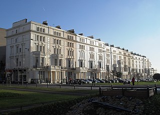
Palmeira Square is a mid-19th-century residential development in Hove, part of the English city and seaside resort of Brighton and Hove. At the southern end it adjoins Adelaide Crescent, another architectural set-piece which leads down to the seafront; large terraced houses occupy its west and east sides, separated by a public garden; and at the north end is one of Hove's main road junctions. This is also called Palmeira Square, and its north side is lined with late 19th-century terraced mansions. Commercial buildings and a church also stand on the main road, which is served by many buses.
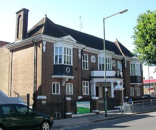
Ralli Hall is a community centre, events venue, theatre stage, business hub and impressive main hall in Hove, part of the English coastal city of Brighton and Hove. Built in 1913 as a memorial to Stephen Ralli, a member of a wealthy Greek family who had donated money to many causes throughout Brighton and Hove, it was used for about 60 years as a church hall linked to Hove's parish church. The Brighton & Hove Jewish community subsequently bought it, and in 1976 it came back into use as a community and social centre for Jewish and other groups. The Wrenaissance-style brick structure occupies a prominent corner site in a conservation area and provides a visual contrast to the older villas around it. English Heritage has listed the building at Grade II for its architectural and historical importance.

The Bear Road area is a largely residential area in the east of Brighton, part of the English city of Brighton and Hove. Centred on the steep west–east road of that name, it is characterised by terraced houses of the early 20th century, but Brighton's main cemeteries were established here in the 19th century and there is also some industry.

Prestonville is a largely residential area in the northwest of Brighton, part of the English city of Brighton and Hove. It covers a long, narrow and steeply sloping ridge of land between the Brighton Main Line and Dyke Road, two major transport corridors which run north-northwestwards from the centre of Brighton. Residential development started in the 1860s and spread northwards, further from central Brighton, over the next six decades. The area is characterised by middle-class and upper-middle-class housing in various styles, small-scale commercial development and long eastward views across the city. Two Anglican churches serve Prestonville—one at each end of the area—and there are several listed buildings.

Elm Grove is a mainly residential area of Brighton, part of the English coastal city of Brighton and Hove. The densely populated district lies on a steep hill northeast of the city centre and developed in the second half of the 19th century after the laying out of a major west–east road, also called Elm Grove. Terraced houses, small shops and architecturally impressive public buildings characterise the streetscape: within the area are a major hospital, two churches and a former board school, as well as Brighton's oldest council houses and an interwar council estate.

Tower House is a former private house in the Withdean area of the English coastal city of Brighton and Hove. Built in 1902 for a former jeweller to King Edward VII, it remained in private ownership until it was converted into flats and a daycare centre in 1988. It is one of the few large houses and villas to survive in the high-class Withdean area—many were demolished in favour of blocks of flats after World War II—and it has been described as "Brighton's finest example of a grand Edwardian house". English Heritage has listed the building at Grade II for its architectural and historical importance.

