West Carrollton, Ohio

Last updated

West Carrollton, Ohio
West Carrollton from 4500 feet.jpg
Aerial view of West Carrollton/ Miamisburg
Montgomery County Ohio incorporated and unincorporated areas West Carrollton highlighted.svg
Location in Montgomery County and the state of Ohio.
Coordinates: 39°40′05″N84°14′50″W / 39.66806°N 84.24722°W / 39.66806; -84.24722
Country United States
State Ohio
County Montgomery
Government
   Mayor Richard Barnhart
Area
[1]
  Total6.65 sq mi (17.23 km2)
  Land6.43 sq mi (16.65 km2)
  Water0.22 sq mi (0.58 km2)
Elevation
[2]
715 ft (218 m)
Population
 (2020)
  Total13,129
  Density2,042.47/sq mi (788.55/km2)
Time zone UTC-5 (Eastern (EST))
  Summer (DST) UTC-4 (EDT)
ZIP code
45449
Area code(s) 937, 326
FIPS code 39-83111 [3]
GNIS feature ID1065462 [2]
Website www.westcarrollton.org

West Carrollton is a city in Montgomery County, Ohio, United States. A suburb of Dayton, its population was 13,129 at the 2020 census. It is part of the Dayton Metropolitan Statistical Area. The Great Miami River runs through the town and forms most of its northern border.

Contents

Geography

According to the United States Census Bureau, the city has a total area of 6.66 square miles (17.25 km2), of which 6.44 square miles (16.68 km2) is land and 0.22 square miles (0.57 km2) is water. [4]

Demographics

Historical population
CensusPop.Note
1850 226
1870 350
1890 360
1900 987174.2%
1910 1,28530.2%
1920 1,43011.3%
1930 2,10146.9%
1940 2,1763.6%
1950 2,87632.2%
1960 4,74965.1%
1970 10,748126.3%
1980 13,14822.3%
1990 14,4039.5%
2000 13,818−4.1%
2010 13,143−4.9%
2020 13,129−0.1%
2021 (est.)13,012−0.9%
Sources: [3] [5] [6] [7] [8] [9]

2010 census

As of the census [10] of 2010, there were 13,143 people, 5,973 households, and 3,378 families living in the city. The population density was 2,040.8 inhabitants per square mile (788.0/km2). There were 6,522 housing units at an average density of 1,012.7 per square mile (391.0/km2). The racial makeup of the city was 86.8% White, 8.9% African American, 0.3% Native American, 1.1% Asian, 0.9% from other races, and 2.0% from two or more races. Hispanic or Latino of any race were 2.6% of the population.

There were 5,973 households, of which 27.3% had children under the age of 18 living with them, 37.4% were married couples living together, 13.4% had a female householder with no husband present, 5.7% had a male householder with no wife present, and 43.4% were non-families. 35.1% of all households were made up of individuals, and 10.7% had someone living alone who was 65 years of age or older. The average household size was 2.18 and the average family size was 2.81.

The median age in the city was 37.5 years. 21.1% of residents were under the age of 18; 9.7% were between the ages of 18 and 24; 29.3% were from 25 to 44; 25.4% were from 45 to 64; and 14.5% were 65 years of age or older. The gender makeup of the city was 48.2% male and 51.8% female.

2000 census

As of the census [3] of 2000, there were 13,818 people, 6,134 households, and 3,704 families living in the city. The population density was 2,190.7 inhabitants per square mile (845.8/km2). There were 6,562 housing units at an average density of 1,040.3 per square mile (401.7/km2). The racial makeup of the city was 92.59% White, 5.21% African American, 0.21% Native American, 1.18% Asian, 0.01% Pacific Islander, 0.51% from other races, and 1.30% from two or more races. Hispanic or Latino of any race were 1.44% of the population.

There were 6,134 households, out of which 27.4% had children under the age of 18 living with them, 45.0% were married couples living together, 11.4% had a female householder with no husband present, and 39.6% were non-families. 32.0% of all households were made up of individuals, and 8.6% had someone living alone who was 65 years of age or older. The average household size was 2.24 and the average family size was 2.83.

In the city the population was spread out, with 22.2% under the age of 18, 10.1% from 18 to 24, 32.8% from 25 to 44, 22.5% from 45 to 64, and 12.4% who were 65 years of age or older. The median age was 35 years. For every 100 females, there were 92.3 males. For every 100 females age 18 and over, there were 88.6 males.

The median income for a household in the city was $40,964, and the median income for a family was $48,832. Males had a median income of $38,382 versus $25,591 for females. The per capita income for the city was $20,721. About 6.1% of families and 7.4% of the population were below the poverty line, including 12.9% of those under age 18 and 6.9% of those age 65 or over.

History

West Carrollton was originally called Carrollton, and under the latter name was laid out in 1830. [11] This change was said to have occurred in response to the amount of mail erroneously received for the second city of Carrollton, OH. [12] Before its current city symbol, the symbol of West Carrollton was a simple pentagon. This resembled the city's rich transportation history, as the small town at one point had five forms of transport running through it: train, canal, riverboats, trolleys and cars.

Education

West Carrollton has a public library, a branch of the Dayton Metro Library. [13] The current superintendent of West Carrollton City Schools is Dr. Andrea Townsend. [ citation needed ]

Related Research Articles

<span class="mw-page-title-main">Montgomery County, Ohio</span> County in Ohio, United States

Montgomery County is located in the southwestern portion of the U.S. state of Ohio. As of the 2020 census, the population was 537,309, making it the fifth-most populous county in Ohio. The county seat is Dayton. The county was named in honor of Richard Montgomery, an American Revolutionary War general killed in 1775 while attempting to capture Quebec City, Canada. Montgomery County is part of the Dayton, Ohio Metropolitan Statistical Area.

<span class="mw-page-title-main">Carroll County, Ohio</span> County in Ohio, United States

Carroll County is a county located in the state of Ohio. As of the 2020 census, the population was 26,721. Its county seat is Carrollton, while its largest village is Minerva. It is named for Charles Carroll of Carrollton, the last surviving signer of the Declaration of Independence.

<span class="mw-page-title-main">Carrollton, Illinois</span> City in Illinois, United States

Carrollton is a city in and the county seat of Greene County, Illinois, United States. The population was 2,484 as of the 2010 census.

<span class="mw-page-title-main">Carrollton, Kentucky</span> City in Kentucky, United States

Carrollton is a home rule-class city in—and the county seat of—Carroll County, Kentucky, United States, at the confluence of the Ohio and Kentucky rivers. The population was 3,938 at the 2010 census.

<span class="mw-page-title-main">Trenton, Ohio</span> City in Ohio, United States

Trenton is a city in northeastern Butler County, Ohio, United States, west of Middletown. The population was 13,021 at the 2020 census. It is part of the Cincinnati metropolitan area.

<span class="mw-page-title-main">Carrollton, Ohio</span> Village in Ohio, United States

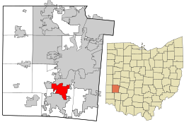
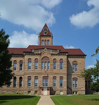
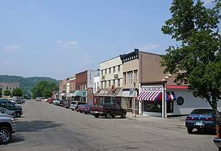
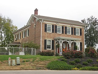
Carrollton is a village in and the county seat of Carroll County, Ohio, located 22 miles (35 km) southeast of Canton. The population was 3,087 at the time of the 2020 census. It is part of the Canton–Massillon metropolitan area.

<span class="mw-page-title-main">Park Layne, Ohio</span> Census-designated place in Ohio, United States

Park Layne is a census-designated place (CDP) in Bethel Township, Clark County, Ohio, United States. The population of the CDP was 4,248 at the 2020 census. It is part of the Springfield, Ohio Metropolitan Statistical Area. Park Layne became a CDP in the 1980 United States Census.

<span class="mw-page-title-main">Groesbeck, Ohio</span> Census-designated place in Ohio, United States

Groesbeck is a census-designated place (CDP) in Hamilton County, Ohio, United States. The population was 7,365 at the 2020 census. It is a suburb of Cincinnati.

<span class="mw-page-title-main">Brookville, Ohio</span> City in Ohio, United States

Brookville is a small city in northwestern Montgomery County, Ohio, United States. It is a suburb of Dayton. The population was 5,989 at the 2020 census.

<span class="mw-page-title-main">Clayton, Ohio</span> City in Ohio, United States

Clayton is a city in Montgomery County, Ohio, United States. The population was 13,310 at the 2020 census. A suburb of Dayton, it is part of the Dayton metropolitan area.

<span class="mw-page-title-main">Farmersville, Ohio</span> Village in Ohio, United States

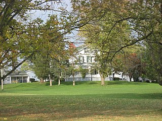
Farmersville is a village in Jackson Township, Montgomery County, Ohio, United States. The population was 975 at the 2020 census. It is part of the Dayton Metropolitan Statistical Area.

<span class="mw-page-title-main">Moraine, Ohio</span> City in Ohio, United States

Moraine is a city in Montgomery County, Ohio, United States. Situated on the banks of the Great Miami River, Moraine is an inner suburb of Dayton, Ohio and a part of the Dayton metropolitan area. The population was 6,393 at the 2020 census.

<span class="mw-page-title-main">New Lebanon, Ohio</span> Village in Ohio, United States

New Lebanon is a village in Montgomery County, Ohio, United States. The population was 3,796 at the 2020 census. It is part of the Dayton Metropolitan Statistical Area.

<span class="mw-page-title-main">Riverside, Ohio</span> City in Ohio, United States

Riverside is a city in Montgomery County, Ohio, United States. The population was 24,474 at the 2020 census. A suburb of Dayton, it is part of the Dayton metropolitan area.

<span class="mw-page-title-main">Trotwood, Ohio</span> City in Ohio, United States

Trotwood is a city in Montgomery County, Ohio, United States. The population was 23,070 at the 2020 census. A suburb of Dayton, it is part of the Dayton metropolitan area. The city is served by the Trotwood-Madison City School District.

<span class="mw-page-title-main">Vandalia, Ohio</span> City in Ohio, United States

Vandalia is a city in Montgomery County, Ohio, United States, and a suburb of Dayton. Its population was 15,209 during the 2020 census. In addition to being the city closest to Dayton International Airport, Vandalia lies at the crossroads of I-75 and I-70.

<span class="mw-page-title-main">Monroe, Ohio</span> City in Ohio, United States

Monroe is a city in east central Butler and west central Warren counties in the southwestern part of the U.S. state of Ohio. The population was 15,412 at the 2020 census. Monroe is a part of the Cincinnati metropolitan area.

<span class="mw-page-title-main">Kettering, Ohio</span> City in Ohio, United States

Kettering is a city in Montgomery County, Ohio, United States. It is an inner suburb of Dayton. As of the 2020 census, the city had a population of 57,862, making it the most populous suburb in the Dayton metropolitan area.

<span class="mw-page-title-main">Union, Ohio</span> City in Ohio, United States

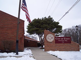
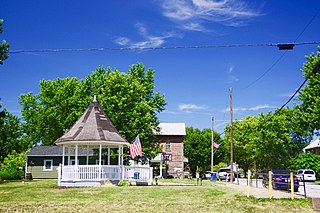
Union is a city in Montgomery and Miami Counties in the U.S. state of Ohio. The population was 6,859 at the time of the 2020 census. It is part of the Dayton Metropolitan Statistical Area.

<span class="mw-page-title-main">Verona, Ohio</span> Village in Ohio, United States

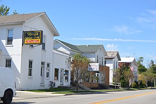
Verona is a village in Montgomery and Preble counties in the U.S. state of Ohio. The population was 403 at the 2020 census. It is part of the Dayton Metropolitan Statistical Area.

References

  1. "ArcGIS REST Services Directory". United States Census Bureau. Retrieved September 20, 2022.
  2. 1 2 U.S. Geological Survey Geographic Names Information System: West Carrollton, Ohio
  3. 1 2 3 "U.S. Census website". United States Census Bureau . Retrieved January 31, 2008.
  4. "US Gazetteer files 2010". United States Census Bureau . Retrieved January 6, 2013.
  5. "Population: Ohio" (PDF). 1910 U.S. Census. U.S. Census Bureau. Retrieved November 28, 2013.
  6. "Population: Ohio" (PDF). 1930 US Census. U.S. Census Bureau. Retrieved November 28, 2013.
  7. "Number of Inhabitants: Ohio" (PDF). 18th Census of the United States. U.S. Census Bureau. 1960. Retrieved May 17, 2020.
  8. "Ohio: Population and Housing Unit Counts" (PDF). U.S. Census Bureau. Retrieved November 22, 2013.
  9. "West Carrollton city, Ohio". census.gov. Retrieved July 7, 2022.
  10. "U.S. Census website". United States Census Bureau . Retrieved January 6, 2013.
  11. Overman, William Daniel (1958). Ohio Town Names. Akron, OH: Atlantic Press. p. 141.
  12. "About". wchistorical-society. Retrieved March 25, 2019.
  13. "Locations". Dayton Metro Library. Retrieved March 1, 2018.