Anguilla is a British Overseas Territory in the Caribbean. It is one of the most northerly of the Leeward Islands in the Lesser Antilles, lying east of Puerto Rico and the Virgin Islands and directly north of Saint Martin. The territory consists of the main island of Anguilla, approximately 16 miles long by 3 miles (5 km) wide at its widest point, together with a number of much smaller islands and cays with no permanent population. The territory's capital is The Valley. The total land area of the territory is 35 square miles (91 km2), with a population of approximately 15,753 (2021).

Anguilla is an island in the Leeward Islands. It has numerous bays, including Barnes, Little, Rendezvous, Shoal, and Road Bays.
This is a demography of the population of Anguilla including population density, ethnicity, education level, health of the populace, economic status, religious affiliations and other aspects of the population.

Anguilla is a town in Sharkey County, Mississippi, United States. The population was 496 at the 2020 census, down from 726 at the 2010 census.

The Valley is the capital of Anguilla, one of its fourteen districts, and the main town on the island. As of 2011, it had a population of 3,269.
Area code 264 is the telephone area code of Anguilla in the North American Numbering Plan (NANP). The area code was created in a split of the original numbering plan area with area code 809. Permissive dialing started 31 March 1997 and ended on 30 September 1997. The area code is also represented on the telephone dial by the letter sequence ANG.

Sint Maarten is a constituent country of the Kingdom of the Netherlands in the Caribbean region of the Americas. With a population of 41,486 as of January 2019 on an area of 34 km2 (13 sq mi), it encompasses the southern 44% of the divided island of Saint Martin, while the northern 56% of the island constitutes the French overseas collectivity of Saint Martin. Sint Maarten's capital is Philipsburg. Collectively, Sint Maarten and the other Dutch islands in the Caribbean are often called the Dutch Caribbean.

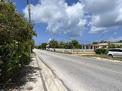
Blowing Point is a village and one of the fourteen Districts of Anguilla, located on the southern coast. It is home to Anguilla's ferry terminal.
East End is one of the fourteen Districts of Anguilla. Its population at the 2011 census was 671.
George Hill is one of the fourteen Districts of Anguilla. Its population at the 2011 census was 879.

Island Harbour is one of the fourteen Districts of Anguilla. Its population at the 2011 census was 988.
North Hill is one of the fourteen Districts of Anguilla. Its population at the 2011 census was 464.
North Side is one of the fourteen Districts of Anguilla. Its population at the 2011 census was 1,980.
Sandy Hill is one of the fourteen Districts of Anguilla. Its population at the 2011 census was 636.

South Hill is one of the fourteen Districts of Anguilla. Its population at the 2011 census was 1,722.
Stoney Ground is one of the fourteen Districts of Anguilla. Its population at the 2011 census was 1,549.
The Quarter is one of the fourteen Districts of Anguilla. Its population at the 2011 census was 959.
The Farrington is one of the fourteen Districts of Anguilla. Its population at the 2011 census was 624.

The Republic of Anguilla was a short-lived, unrecognised independent state on the island of Anguilla. It lasted from 11 July 1967 until 19 March 1969, when British control was re-established.
Government House is the official residence of the governor of Anguilla, located in Old Ta in Anguilla.