West Ocean City, Maryland

Last updated

West Ocean City, Maryland
CDP
Worcester County Maryland Incorporated and Unincorporated areas West Ocean City Highlighted.svg
Location of West Ocean City, Maryland
USA Maryland location map.svg
Red pog.svg
West Ocean City
Location within the state of Maryland
Usa edcp location map.svg
Red pog.svg
West Ocean City
West Ocean City (the United States)
Coordinates: 38°20′6″N75°6′45″W / 38.33500°N 75.11250°W / 38.33500; -75.11250
CountryUnited States
State Maryland
County Worcester
Area
[1]
  Total7.04 sq mi (18.24 km2)
  Land4.19 sq mi (10.85 km2)
  Water2.85 sq mi (7.39 km2)
Elevation
7 ft (2 m)
Population
 (2020)
  Total4,952
  Density1,181.86/sq mi (456.37/km2)
Time zone UTC−5 (Eastern (EST))
  Summer (DST) UTC−4 (EDT)
ZIP code
21842
Area code(s) 410, 443
FIPS code 24-83225
GNIS feature ID0591524

West Ocean City is a census-designated place (CDP) in Worcester County, Maryland, United States. The population was 4,375 at the 2010 census. It is part of the Salisbury, Maryland-Delaware Metropolitan Statistical Area.

Contents

Geography

West Ocean City is located at 38°20′6″N75°6′45″W / 38.33500°N 75.11250°W / 38.33500; -75.11250 (38.335010, 75.112474). [2] It is located across the Sinepuxent Bay from Ocean City.

According to the United States Census Bureau, the CDP has a total area of 6.6 square miles (17 km2), of which 4.0 square miles (10 km2) is land and 2.6 square miles (6.7 km2) (39.22%) is water.

Climate

The climate in this area is characterized by hot, humid summers and generally mild to cool winters. According to the Köppen Climate Classification system, West Ocean City has a humid subtropical climate, abbreviated "Cfa" on climate maps. [3]

Demographics

Historical population
CensusPop.Note
2020 4,952
U.S. Decennial Census [4]

As of the census [5] of 2000, there were 3,311 people, 1,425 households, and 967 families residing in the CDP. The population density was 822.4 inhabitants per square mile (317.5/km2). There were 2,075 housing units at an average density of 515.4 per square mile (199.0/km2). The racial makeup of the CDP was 96.04% White, 1.60% African American, 0.42% Native American, 0.66% Asian, 0.03% Pacific Islander, 0.06% from other races, and 1.18% from two or more races. Hispanic or Latino of any race were 1.42% of the population.

There were 1,425 households, out of which 23.7% had children under the age of 18 living with them, 57.1% were married couples living together, 8.4% had a female householder with no husband present, and 32.1% were non-families. 25.1% of all households were made up of individuals, and 8.6% had someone living alone who was 65 years of age or older. The average household size was 2.32 and the average family size was 2.77.

In the CDP, the population was spread out, with 19.8% under the age of 18, 5.0% from 18 to 24, 27.9% from 25 to 44, 28.3% from 45 to 64, and 19.1% who were 65 years of age or older. The median age was 44 years. For every 100 females, there were 97.2 males. For every 100 females age 18 and over, there were 95.0 males.

The median income for a household in the CDP was $42,279, and the median income for a family was $51,111. Males had a median income of $30,444 versus $27,222 for females. The per capita income for the CDP was $28,132. About 3.0% of families and 5.0% of the population were below the poverty line, including 4.1% of those under age 18 and 3.1% of those age 65 or over.

Tourism

West Ocean City is located along U.S. Route 50 across the Harry W. Kelley Memorial Bridge over the Sinepuxent Bay from the beach resort town of Ocean City. The area is home to fishing charters, boating, marinas, and the Outlets Ocean City. [6]

Related Research Articles

<span class="mw-page-title-main">Worcester County, Maryland</span> County in Maryland, United States

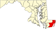
Worcester County is the easternmost county of the U.S. state of Maryland. As of the 2020 census, the population was 52,460. Its county seat is Snow Hill.

<span class="mw-page-title-main">Whale Pass, Alaska</span> Second Class City in Alaska, United States

Whale Pass is a second class city in Prince of Wales-Hyder Census Area, Alaska, United States. The population was 31 at the 2010 census, down from 58 in 2000.

<span class="mw-page-title-main">Stearns, Kentucky</span> Census-designated place in Kentucky, United States

Stearns is an unincorporated community and census-designated place (CDP) in McCreary County, Kentucky, United States. The population was 1,365 at the 2020 census. It was founded by Justus Smith Stearns.

<span class="mw-page-title-main">Brooklyn Park, Maryland</span> Census-designated place in Maryland, United States

Brooklyn Park is a census-designated place (CDP) in Anne Arundel County, Maryland, United States. The population was 14,373 at the 2010 census.

<span class="mw-page-title-main">Ferndale, Maryland</span> Census-designated place in Maryland, United States

Ferndale is a census-designated place (CDP) in Anne Arundel County, Maryland, United States. At the 2010 census, the population was 16,746.

<span class="mw-page-title-main">Shady Side, Maryland</span> Census-designated place in Maryland, United States

Shady Side is a census-designated place (CDP) in Anne Arundel County, Maryland, United States. The population was 5,803 at the 2010 census.

<span class="mw-page-title-main">Lochearn, Maryland</span> Census-designated place in Maryland, United States

Lochearn is an unincorporated community and census-designated place in Baltimore County, Maryland, United States, located immediately to the west of the City of Baltimore. Per the 2020 census, the population was 25,511.

<span class="mw-page-title-main">Dunkirk, Maryland</span> Census-designated place in Maryland, United States

Dunkirk is a census-designated place (CDP) in Calvert County, Maryland, United States. The population was 2,521 at the 2010 census.

<span class="mw-page-title-main">Solomons, Maryland</span> Census-designated place in Maryland, United States

Solomons, also known as Solomons Island, is an unincorporated community and census-designated place (CDP) in Calvert County, Maryland, United States. The population was 2,368 at the 2010 census, up from 1,536 in 2000. Solomons is a popular weekend destination spot in the Baltimore–Washington metropolitan area.

<span class="mw-page-title-main">Perryman, Maryland</span> Census-designated place in Maryland, United States

Perryman is an unincorporated community and census-designated place (CDP) in Harford County, Maryland, United States. The population was 2,342 at the 2010 census.

<span class="mw-page-title-main">Mount Vernon, Maryland</span> CDP in Maryland, United States

Mount Vernon is a census-designated place (CDP) in Somerset County, Maryland, United States. The population was 761 at the 2000 census. It is included in the Salisbury, Maryland-Delaware Metropolitan Statistical Area.

<span class="mw-page-title-main">Princess Anne, Maryland</span> Town in Maryland, United States

Princess Anne is a town in Somerset County, Maryland, United States, that also serves as its county seat. Its population was 3,290 at the 2010 census. It is included in the Salisbury, Maryland–Delaware Metropolitan Statistical Area.

<span class="mw-page-title-main">West Pocomoke, Maryland</span> CDP in Maryland, United States

West Pocomoke is a census-designated place (CDP) in Somerset County, Maryland, United States. The population was 498 at the 2000 census. It is included in the Salisbury, Maryland-Delaware Metropolitan Statistical Area.

<span class="mw-page-title-main">Cordova, Maryland</span> Village in Maryland, United States

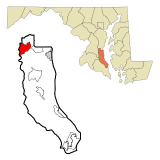
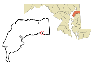
Cordova is a village in Talbot County, Maryland, United States. The population was 592 at the 2000 census.

<span class="mw-page-title-main">Tilghman Island, Maryland</span> CDP in Maryland, United States

Tilghman Island is an island in the Chesapeake Bay. It is part of Talbot County, Maryland, United States.

<span class="mw-page-title-main">Berlin, Maryland</span> Town in Maryland, United States

Berlin is a town in Worcester County, Maryland, United States which includes its own historical Berlin Commercial District. The population was 4,485 at the 2010 census, and has since grown in population. It is part of the Salisbury, Maryland-Delaware Metropolitan Statistical Area.

<span class="mw-page-title-main">Belcourt, North Dakota</span> CDP in North Dakota, United States

Belcourt is a census-designated place (CDP) in Rolette County, North Dakota, United States. It is within the Turtle Mountain Indian Reservation. The population was 1,510 at the 2020 census.

<span class="mw-page-title-main">Kenilworth, Pennsylvania</span> Census-designated place in Pennsylvania, United States

Kenilworth is a census-designated place (CDP) in North Coventry Township, Chester County, Pennsylvania, United States. The population was 2,148 at the 2020 census.

<span class="mw-page-title-main">Oliver, Pennsylvania</span> Census-designated place in Pennsylvania, United States

Oliver is a census-designated place (CDP) in Fayette County, Pennsylvania, United States. The population was 2,535 at the 2010 census, down from 2,925 at the 2000 census. Oliver is located in North Union Township.

<span class="mw-page-title-main">Millington, Maryland</span> Town in Maryland, United States

Millington is a town in Kent and Queen Anne's counties in the U.S. state of Maryland. The population was 642 at the 2010 census. Millington is the head of navigation for the Chester River.

References

  1. "2020 U.S. Gazetteer Files". United States Census Bureau. Retrieved April 26, 2022.
  2. "US Gazetteer files: 2010, 2000, and 1990". United States Census Bureau. February 12, 2011. Retrieved April 23, 2011.
  3. Climate Summary for West Ocean City, Maryland
  4. "Census of Population and Housing". Census.gov. Retrieved June 4, 2016.
  5. "U.S. Census website". United States Census Bureau . Retrieved January 31, 2008.
  6. "Ocean City Maps". Ocean City, Maryland - Tourism. Retrieved June 13, 2017.