
Johannesburg is a large city in Gauteng Province of South Africa. It was established as a small village controlled by a Health Committee in 1886 with the discovery of an outcrop of a gold reef on the farm Langlaagte. The population of the city grew rapidly, becoming a municipality in 1898. In 1928 it became a city making Johannesburg the largest city in South Africa. In 2002 it joined ten other municipalities to form the City of Johannesburg Metropolitan Municipality. Today, it is a centre for learning and entertainment for all of South Africa. It is also the capital city of Gauteng.
The University of Johannesburg (UJ) is a public university located in Johannesburg, South Africa. The University of Johannesburg came into existence on 1 January 2005 as the result of a merger between the Rand Afrikaans University (RAU), the Technikon Witwatersrand (TWR) and the Soweto and East Rand campuses of Vista University. Prior to the merger, the Daveyton and Soweto campuses of the former Vista University had been incorporated into RAU. As a result of the merger of Rand Afrikaans University (RAU), it is common for alumni to refer to the university as RAU. The vice-chancellor and principal of UJ is Professor Tshilidzi Marwala who took office on 1 January 2018. Between 2005 and 2017, UJ's vice-chancellor and principal was Prof Ihron Lester Rensburg.
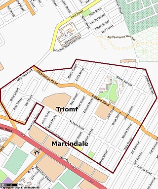
Sophiatown, also known as Sof'town or Kofifi, is a suburb of Johannesburg, South Africa. Sophiatown was a black cultural hub that was destroyed under apartheid, It produced some of South Africa's most famous writers, musicians, politicians and artists. Rebuilt under the name of Triomf, and in 2006 officially returned to its original name. Sophiatown was one of the oldest black areas in Johannesburg and its destruction represents some of the excesses of South Africa under apartheid.

Alberton is a city situated on the southern part of the East Rand of the Gauteng Province in South Africa and is situated very close to the major urban centre of Johannesburg.

Roodepoort is a town in the Gauteng province of South Africa. Formerly an independent municipality, Roodepoort became part of the Johannesburg municipality in the late 1990s, along with Randburg and Sandton. Johannesburg's most famous botanical garden, Witwatersrand National Botanical Gardens, is located in Roodepoort.

The suburbs of Johannesburg are officially demarcated areas within the City of Johannesburg Metropolitan Municipality, South Africa. As in other Commonwealth countries, the term suburb refers to a "neighbourhood", although in South Africa as most "suburbs" have legally recognised borders and often separate postal codes. The municipal functions for the area, such as municipal policing and social services, are still managed by the city government.

Melville is a bohemian suburb of Johannesburg, Gauteng, South Africa. It is the location of many restaurants and taverns, which are mostly frequented by students from the nearby University of Johannesburg, located in Auckland Park, and the University of the Witwatersrand, located in Braamfontein. It is one of the city's most popular tourist destinations. The suburb is to the west of the Johannesburg CBD. It is located in Region B of the City of Johannesburg Metropolitan Municipality.
Auckland Park is a suburb of Johannesburg, South Africa. It lies on a gentle slope, and is in close proximity to the suburbs of Melville, Brixton, Westdene and Richmond. Auckland Park is one of the few suburbs close to the Johannesburg city centre that has remained largely unaffected by the recent migration of Johannesburg residents to the city's northern suburbs. Auckland Park is home to a mix of nationalities and cultures, and the suburb is well known as the location of the South African Broadcasting Corporation headquarters.
Orange Grove is a suburb of Johannesburg, South Africa. It is located in Region E of the City of Johannesburg Metropolitan Municipality.
Emmarentia is a suburb of Johannesburg, South Africa.
Randpark Ridge is an upmarket suburb of Randburg, South Africa. It is located in the Randburg region of the City of Johannesburg. It fell into the town of Randburg during the apartheid era. Developed in the early 1980s and still relatively new, Randpark Ridge is bordered by several other suburbs including Weltevreden Park, Sundowner, Boskruin, Bromhof, Honeydew and Fairland. It is located on the north-west extremity of Johannesburg.

The Johannesburg Botanical Garden is located in the suburb of Emmarentia in Johannesburg, South Africa. The gardens grew out of a large rose garden that was established in 1964 and subsequently expanded from 1969 to cover an area of around 125 hectares (1.25 km2). It is administered by Johannesburg City Parks. The Emmarentia Dam is situated immediately to the east of the garden and shares its extensive acreage. One of the main attractions is the Rose Garden with over 10 000 roses.

Emmarentia Dam is a dam in Emmarentia, Johannesburg, South Africa. There are several dams that make up Emmarentia Dam, despite its allusion to the singular, with two small dams found upstream in the Johannesburg Botanical Gardens.

Kingsway Campus Auckland Park, also known as APK, is the largest and most populated of the four campuses of the University of Johannesburg. It is also the seat of the administration and governance body of the university. The campus was formerly the only educational campus of the Rand Afrikaans University. The campus gets its name from a major Johannesburg road, Kingsway Avenue, that runs along the north-east side of the campus. The roads that form the boundary of the campus are (clock-wise) University Road, Ditton Avenue, Ripley Road, Hampton Avenue, Studente Avenue, Akademie Road and Perth Road. Although the official name of the campus implies that it is in Auckland Park, it actually falls just out of that suburb by one street. It is technically in the suburb of Rossmore with the first-year parking lot bordering the suburb of Melville, Gauteng.
Bunting Road Campus Auckland Park, also known as APB, is one of the four urban campuses of the University of Johannesburg. The APB was originally a campus of the Technikon Witwatersrand.
Vrededorp is a suburb of Johannesburg, South Africa. It is located in Region F of the City of Johannesburg Metropolitan Municipality. Vrededorp is situated on the North-Western side of Johannesburg and is 1,764 m (5,788 ft) above sea level.
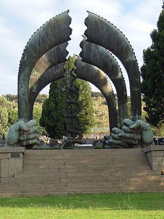
Westpark Cemetery is a large cemetery in Johannesburg, South Africa, and is the resting place of some of the country's well-known citizens. It is a non-denomination designated burial ground, and thus has Christian, Jewish, Muslim and Chinese burial areas. The Jewish section contains a Holocaust Memorial, erected in 1959.
Rossmore is a suburb of Johannesburg, around 5 km northwest of City Hall. It borders Langlaagte to the north and Homestead Park. The name comes from the village of Paarlshoop, the oldest private township on the Witwatersrand.
The Johannesburg Reformed Church was the first congregation of the Dutch Reformed Church in South Africa (NGK) to be founded in Johannesburg on August 14, 1887. All the congregations on the Witwatersrand stem from it, but by the 2010s, the NGK yearbook recorded only 90 in its ward which had long ceased to operate independently.
The Johannesburg East Reformed Church was a congregation of the Dutch Reformed Church in South Africa (NGK) in the Johannesburg suburb of Doornfontein, just east of downtown. It is also known as the Irene Church after the sobriquet of its second and third churches on 1 Beit Street. Five weeks before its centennial, on June 1, 1997, Johannesburg East was absorbed by the Johannesburg Reformed Church (NGK), from whence it had seceded on July 8, 1897.


