Hillbrow is an inner city residential neighbourhood of Johannesburg, Gauteng Province, South Africa. It is known for its high levels of population density, unemployment, poverty, prostitution and crime.

Johannesburg is a large city in Gauteng Province of South Africa. It was established as a small village controlled by a Health Committee in 1886 with the discovery of an outcrop of a gold reef on the farm Langlaagte. The population of the city grew rapidly, becoming a municipality in 1898. In 1928 it became a city making Johannesburg the largest city in South Africa. In 2002 it joined ten other municipalities to form the City of Johannesburg Metropolitan Municipality. Today, it is a centre for learning and entertainment for all of South Africa. It is also the capital city of Gauteng.

The suburbs of Johannesburg are officially demarcated areas within the City of Johannesburg Metropolitan Municipality, South Africa. As in other Commonwealth countries, the term suburb refers to a "neighbourhood", although in South Africa most "suburbs" have legally recognised borders and often separate postal codes. The municipal functions for the area, such as municipal policing and social services, are still managed by the city government.
Yeoville is an inner city neighbourhood of Johannesburg, in the province of Gauteng, South Africa. It is located in Region F. From the 1920s onwards it became a significant enclave of German Jewish immigrants. Beginning in the late 1970s, some white middle class residents began to move to the northern suburbs. This process of white flight accelerated in the early to mid 1990s. Today, it is widely known and celebrated for its diverse, pan-African population but notorious for its high levels of crime, poverty and degradation.
Heriotdale is a suburb of Johannesburg, South Africa. The suburb lying south of Malvern and north of Rosherville, is an industrial area. It is located in Region F of the City of Johannesburg Metropolitan Municipality.
City and Suburban is a suburb of Johannesburg, South Africa, just east of the city centre. It is a relatively small residential and business area, inhabited by 2 703 (99,4%) an overwhelming Black majority, according to the 2011-census. It is located in Region F of the City of Johannesburg Metropolitan Municipality.
Houghton Estate, often simply called Houghton, is an affluent suburb of Johannesburg, South Africa, north-east of the city centre.

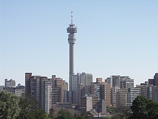
The Johannesburg Central Business District, commonly called Johannesburg CBD, is one of the main business centres of Johannesburg, South Africa. It is the densest collection of skyscrapers in Africa, however, due to white flight and urban blight, many of the buildings are unoccupied as tenants have left for more secure locations in the Northern Suburbs, in particular Sandton and Rosebank. There are significant movements to revive the area.
Bellevue is an inner city neighbourhood of Johannesburg, Gauteng Province, South Africa. Close to the Johannesburg CBD with the neighbourhood surrounded by Yeoville and Observatory. It is located in Region F of the City of Johannesburg Metropolitan Municipality. It shares the same praise and notoriety as its surrounding neighbourhood Yeoville.
Berea is an inner city neighbourhood of Johannesburg, in the South African province of Gauteng. It is east and adjacent to the Johannesburg CBD. It is located in Region F of the City of Johannesburg Metropolitan Municipality.
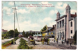
Doornfontein is an inner-city suburb of Johannesburg, South Africa, located to the east of the city centre, Region 8. In the 1930s, it attracted many Jewish immigrants, becoming the main hub for the city's Jewish community. Black African residents, then a minority in the suburb, lived in slum-yards. Under the Slums Clearance Act 1934, the slum-yards were cleared and many residents were relocated to Orlando, Soweto. Since the late 1970s, Doornfontein and other inner-city suburbs of Johannesburg have underdone high levels of white flight to the city's northern suburbs.
Fairview is a suburb of Johannesburg, South Africa. It is a small suburb found on the eastern edge of the Johannesburg central business district (CBD), with the suburb of Troyeville to the north, Jeppestown to the south and Malvern to its east. Commissioner Street, the main street in the CBD, has its eastern end in the suburb. It is located in Region F of the City of Johannesburg Metropolitan Municipality.
Ferreirasdorp is an inner-city suburb of Johannesburg, South Africa located in Region F of the City of Johannesburg Metropolitan Municipality.
Judith's Paarl is a suburb of Johannesburg, South Africa. It is a small suburb found on the eastern edge of the Johannesburg central business district (CBD), tucked between the suburbs of Lorentzville and Bezuidenhout Valley, with Troyeville and Kensington to the south. It is located in Region F of the City of Johannesburg Metropolitan Municipality.
Louis Botha Avenue is a major street in Johannesburg, South Africa. Originally part of the main road between central Johannesburg and Pretoria, it runs along through the north-eastern parts of the city from Hillbrow to Sandton, passing through numerous older suburbs, including Houghton and Orange Grove, before it becomes the Pretoria Main Road (R101) which passes the Alexandra Township and continues to Midrand and Pretoria.
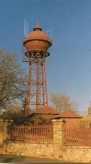
The Yeoville Water Tower is located in Harley and Percy Streets, Yeoville, near the fountain of Doornfontein; it was built in 1914 by the Sivewright's Johannesburg Waterworks, Estate and Exploration company. It was constructed with a reservoir to supply piped water to Johannesburg.
The Doornfontein Synagogue or Lions Synagogue is the oldest synagogue still in use in Johannesburg, South Africa.
Temple Israel is the oldest of eleven Progressive synagogues in South Africa. It is a provincial heritage site, built in the Art Deco style by architect Hermann Kallenbach. It is located in the Johannesburg suburb of Hillbrow. It is an affiliate of the South African Union for Progressive Judaism (SAUPJ), which is part of the World Union for Progressive Judaism (WUPJ).
Josias Eduard de Villiers was a Cape Colony and South African Republic surveyor, politician, and amateur astronomer. He surveyed the first neighborhood in Johannesburg, Randjeslaagte. He predicted that Johannesburg would become a city rather than disappearing like other ghost towns, and De Villiers Street there is named after him.
M11 is a major metropolitan route in Greater Johannesburg, South Africa. Historically it was part of the main road between Johannesburg and Pretoria; it now runs through the central and north-eastern parts of the city from Bassonia, passing through Johannesburg CBD and Hillbrow, passing through numerous older suburbs, including Houghton and Orange Grove and the Alexandra Township as Louis Botha Avenue, before it becomes the Old Pretoria Road (R101) and continues to Midrand and Pretoria.


