White Oak, North Carolina

Last updated

White Oak, North Carolina
Bladen County North Carolina incorporated and unincorporated areas White Oak highlighted.svg
Location in Bladen County and the state of North Carolina.
Coordinates: 34°44′41″N78°45′07″W / 34.74472°N 78.75194°W / 34.74472; -78.75194
Country United States
State North Carolina
County Bladen
Area
[1]
  Total5.11 sq mi (13.23 km2)
  Land5.11 sq mi (13.23 km2)
  Water0.00 sq mi (0.00 km2)
Elevation
[2]
69 ft (21 m)
Population
 (2020)
  Total346
  Density67.74/sq mi (26.15/km2)
Time zone UTC-5 (Eastern (EST))
  Summer (DST) UTC-4 (EDT)
ZIP code
28399
Area codes 910, 472
FIPS code 37-73320 [3]
GNIS feature ID2403022 [2]

White Oak is a census-designated place (CDP) in Bladen County, North Carolina, United States. The population was 338 at the 2010 census. [4]

Contents

History

Desserette and Harmony Hall are listed on the National Register of Historic Places. [5]

Geography

According to the United States Census Bureau, the CDP has a total area of 5.1 square miles (13.2 km2), all land. [4]

Demographics

Historical population
CensusPop.Note
2020 346
U.S. Decennial Census [6]

As of the census [3] of 2000, there were 304 people, 107 households, and 81 families residing in the CDP. The population density was 62.3 inhabitants per square mile (24.1/km2). There were 120 housing units at an average density of 24.6/sq mi (9.5/km2). The racial makeup of the CDP was 60.53% White, 34.54% African American, 1.32% Native American, 2.96% from other races, and 0.66% from two or more races. Hispanic or Latino of any race were 5.59% of the population.

There were 107 households, out of which 38.3% had children under the age of 18 living with them, 60.7% were married couples living together, 11.2% had a female householder with no husband present, and 23.4% were non-families. 17.8% of all households were made up of individuals, and 11.2% had someone living alone who was 65 years of age or older. The average household size was 2.79 and the average family size was 3.20.

In the CDP, the population was spread out, with 27.0% under the age of 18, 8.9% from 18 to 24, 34.5% from 25 to 44, 18.8% from 45 to 64, and 10.9% who were 65 years of age or older. The median age was 32 years. For every 100 females, there were 104.0 males. For every 100 females age 18 and over, there were 109.4 males.

The median income for a household in the CDP was $41,000, and the median income for a family was $42,292. Males had a median income of $30,774 versus $28,750 for females. The per capita income for the CDP was $14,401. None of the families and 4.9% of the population were living below the poverty line, including no under eighteens and 22.2% of those over 64.

Related Research Articles

<span class="mw-page-title-main">Oak Ridge, Florida</span> Census-designated place in Florida, United States

Oak Ridge is a census-designated place and unincorporated area in Orange County, Florida, United States. The population was 22,685 at the 2010 census. It is part of the Orlando–Kissimmee–Sanford, Florida Metropolitan Statistical Area.

<span class="mw-page-title-main">Altamahaw, North Carolina</span> Census-designated place in North Carolina, United States

Altamahaw is a census-designated place (CDP) in Alamance County, North Carolina, United States. It is part of the Burlington, North Carolina Metropolitan Statistical Area. As of the 2010 census it had a population of 347. The community was listed as Altamahaw-Ossipee at the 2000 census, at which time the population was 996. The town of Ossipee incorporated in 2002 and currently has a population of 543. The remainder of the territory was reassigned as the Altamahaw CDP.

Light Oak is an unincorporated area and census-designated place (CDP) in Cleveland County, North Carolina, United States. The population was 691 at the 2010 census.

<span class="mw-page-title-main">Welcome, North Carolina</span> Census-designated place in North Carolina, United States

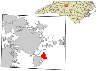
Welcome is a census-designated place (CDP) in Davidson County, North Carolina, United States. The population was 4,162 at the 2010 census. It is nationally known as the home of Richard Childress Racing. In addition, Walker and Associates, Inc., a nationwide communication value-add distribution is headquartered here. The town motto is "Welcome to Welcome, A Friendly Place," as posted on the welcoming sign. Neighboring communities and municipalities include Midway, Arcadia, and Lexington.

<span class="mw-page-title-main">Forest Oaks, North Carolina</span> Census-designated place in North Carolina, United States

Forest Oaks is a census-designated place (CDP) in Guilford County, North Carolina, United States. The population was 3,890 as of the 2010 census, up from 3,241 in 2000.

Delway is a census-designated place (CDP) in Sampson County, North Carolina, United States. The population was 150 at the 2020 U.S. census.

Ingold is a census-designated place (CDP) in Sampson County, North Carolina, United States. The population was 484 at the 2000 census.

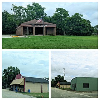
Ivanhoe is a census-designated place (CDP) in Sampson County, North Carolina, United States. The population was 198 at the 2020 U.S. census.

<span class="mw-page-title-main">White Plains, North Carolina</span> CDP in North Carolina, United States

White Plains is a census-designated place (CDP) in Surry County, North Carolina, United States. The population was 1,049 at the 2000 census.

<span class="mw-page-title-main">White Oak, Ohio</span> Census-designated place in Ohio, United States

White Oak is a census-designated place (CDP) in Hamilton County, Ohio, United States. It is seven miles northwest of Cincinnati. The population was 19,541 at the 2020 census. White Oak is situated in both Green Township and Colerain Township.

<span class="mw-page-title-main">Coronaca, South Carolina</span> Census-designated place in South Carolina, United States

Coronaca is an unincorporated community and census-designated place (CDP) in Greenwood County, South Carolina, United States. The population was 191 at the 2010 census.

<span class="mw-page-title-main">Oak Grove, South Carolina</span> Census-designated place in South Carolina, United States

Oak Grove is a census-designated place (CDP) in Lexington County, South Carolina, United States. The population was 10,291 at the 2010 census. It is part of the Columbia Metropolitan Statistical Area.

Seven Oaks is a census-designated place (CDP) in Lexington County, South Carolina, United States, 8 miles (13 km) northwest of downtown Columbia, the state capital. The population of the CDP was 15,144 at the 2010 census. It is part of the Columbia Metropolitan Statistical Area.

<span class="mw-page-title-main">Clarks Hill, South Carolina</span> CDP in South Carolina, United States

Clarks Hill is a census-designated place (CDP) in McCormick County, South Carolina, United States. The population was 376 at the 2000 census.

<span class="mw-page-title-main">Mount Carmel, South Carolina</span> CDP in South Carolina, United States

Mt. Carmel is a census-designated place (CDP) in McCormick County, South Carolina, United States. The population was 237 at the 2000 census.

<span class="mw-page-title-main">Willington, South Carolina</span> CDP in South Carolina, United States

Willington is a census-designated place (CDP) in McCormick County, South Carolina, United States. The population was 177 at the 2000 census.

<span class="mw-page-title-main">St. Andrews, South Carolina</span> Census-designated place in South Carolina, United States

St. Andrews is a census-designated place (CDP) in Richland County, South Carolina, United States. The population was 20,493 at the 2010 census. It is part of the Columbia, South Carolina Metropolitan Statistical Area.

<span class="mw-page-title-main">Roebuck, South Carolina</span> CDP in South Carolina, United States

Roebuck is a census-designated place (CDP) in Spartanburg County, South Carolina, United States. The population was 2,200 at the 2010 census.

<span class="mw-page-title-main">Rembert, South Carolina</span> Town in South Carolina, United States

Rembert is a town in Sumter County, South Carolina, United States. The population was 306 at the 2010 census, a decline from 406 in 2000. It is included in the Sumter, South Carolina Metropolitan Statistical Area.

<span class="mw-page-title-main">Oak Level, Virginia</span> CDP in Virginia, United States

Oak Level is a census-designated place (CDP) in Henry County, Virginia, United States. The population was 857 at the 2010 census. It is part of the Martinsville Micropolitan Statistical Area.

References

  1. "ArcGIS REST Services Directory". United States Census Bureau. Retrieved September 20, 2022.
  2. 1 2 U.S. Geological Survey Geographic Names Information System: White Oak, North Carolina
  3. 1 2 "U.S. Census website". United States Census Bureau . Retrieved January 31, 2008.
  4. 1 2 "Geographic Identifiers: 2010 Demographic Profile Data (G001): White Oak CDP, North Carolina". U.S. Census Bureau, American Factfinder. Archived from the original on February 12, 2020. Retrieved February 6, 2014.
  5. "National Register Information System". National Register of Historic Places . National Park Service. July 9, 2010.
  6. "Census of Population and Housing". Census.gov. Retrieved June 4, 2016.