Whitehall, Wisconsin

Last updated

Whitehall, Wisconsin
Whitehall, Wisconsin.jpg
Trempealeau County Wisconsin Incorporated and Unincorporated areas Whitehall Highlighted.svg
Location of Whitehall in Trempealeau County, Wisconsin.
Coordinates: 44°22′0″N91°18′59″W / 44.36667°N 91.31639°W / 44.36667; -91.31639
Country Flag of the United States.svg  United States
State Flag of Wisconsin.svg  Wisconsin
County Trempealeau
Area
[1]
  Total3.81 sq mi (9.85 km2)
  Land3.81 sq mi (9.85 km2)
  Water0.00 sq mi (0.00 km2)
Elevation
[2]
817 ft (249 m)
Population
 (2020) [3]
  Total1,645
  Density413.14/sq mi (159.53/km2)
Time zone UTC-6 (Central (CST))
  Summer (DST) UTC-5 (CDT)
ZIP Code
54773
Area code(s) 715 & 534
FIPS code 55-86725 [4]
GNIS feature ID1576681 [2]
Website sites.google.com/site/cityofwhitehallwi/

Whitehall is a city and the county seat of Trempealeau County, Wisconsin, United States, along the Trempealeau River. The population was 1,645 at the 2020 census. [5]

Contents

Whitehall is situated on the former Green Bay and Western Railroad midway between La Crosse and Eau Claire.

History

Whitehall, 1911 Whitehall, Wisconsin (1911).jpg
Whitehall, 1911

Whitehall was started in 1860 or 1861, in an area later known as Old Whitehall about a mile from the center of the current city, by Ole Knudtson. He came to Whitehall June 25, 1860, and opened a hotel and blacksmith shop. The proprietors of the town site were Benjamin Franklin Wing and Mr. Georges. [6] A post office called Whitehall was first established in 1861. [7] The city was named by Benjamin F. Wing, possibly after White Hall, Illinois and Whitehall, New York. [8]

The Green Bay railroad was built through the valley of the Trempealeau River in 1873. "The tracks were laid through the wheat field that is now Whitehall, on Sept. 2, 1873. ... Where the courthouse now stands, the harvesters were gathering wheat. ... On New Year's Day, 1874, the first passenger train passed Whitehall on regular schedule. That same day the lumber was unloaded for the first depot ..." [9] Whitehall was incorporated in 1887.

Geography

According to the United States Census Bureau, the city has a total area of 2.80 square miles (7.25 km2), all of it land. [10]

Demographics

Historical population
CensusPop.Note
1880 267
1890 30413.9%
1900 60097.4%
1910 70317.2%
1920 85121.1%
1930 9157.5%
1940 1,03513.1%
1950 1,37933.2%
1960 1,4464.9%
1970 1,4862.8%
1980 1,5303.0%
1990 1,494−2.4%
2000 1,65110.5%
2010 1,558−5.6%
2020 1,6455.6%
U.S. Decennial Census [11]

2010 census

As of the census [3] of 2010, there were 1,558 people, 665 households, and 382 families living in the city. The population density was 556.4 inhabitants per square mile (214.8/km2). There were 741 housing units at an average density of 264.6 per square mile (102.2/km2). The racial makeup of the city was 96.9% White, 0.4% African American, 0.1% Native American, 0.4% Asian, 1.5% from other races, and 0.6% from two or more races. Hispanic or Latino of any race were 4.2% of the population.

There were 665 households, of which 27.4% had children under the age of 18 living with them, 43.8% were married couples living together, 9.5% had a female householder with no husband present, 4.2% had a male householder with no wife present, and 42.6% were non-families. 36.4% of all households were made up of individuals, and 16.5% had someone living alone who was 65 years of age or older. The average household size was 2.24 and the average family size was 2.92.

The median age in the city was 42 years. 23.2% of residents were under the age of 18; 7.6% were between the ages of 18 and 24; 22.7% were from 25 to 44; 26.7% were from 45 to 64; and 19.7% were 65 years of age or older. The gender makeup of the city was 48.8% male and 51.2% female.

2000 census

As of the census [4] of 2000, there were 1,651 people, 693 households, and 415 families living in the city. The population density was 991.2 people per square mile (381.7/km2). There were 733 housing units at an average density of 440.1 per square mile (169.5/km2). The racial makeup of the city- fairly typical for its locality- was 99.64% White, 0.12% African American, 0.06% Native American, 0.06% Asian, 0.06% from other races, and 0.06% from two or more races. Hispanic or Latino of any race were 0.30% of the population.

There were 693 households, out of which 29.9% had children under the age of 18 living with them, 48.3% were married couples living together, 8.5% had a female householder with no husband present, and 40.0% were non-families. 35.6% of all households were made up of individuals, and 20.6% had someone living alone who was 65 years of age or older. The average household size was 2.25 and the average family size was 2.95.

In the city, the population was spread out, with 23.7% under the age of 18, 6.7% from 18 to 24, 26.3% from 25 to 44, 21.4% from 45 to 64, and 21.9% who were 65 years of age or older. The median age was 40 years. For every 100 females, there were 92.4 males. For every 100 females age 18 and over, there were 89.5 males.

The median income for a household in the city was $33,958, and the median income for a family was $48,047. Males had a median income of $28,643 versus $21,332 for females. The per capita income for the city was $17,743. About 4.1% of families and 7.3% of the population were below the poverty line, including 7.3% of those under age 18 and 7.6% of those age 65 or over.

Education

Whitehall School District operates area public schools.

Whitehall High School Whitehall High School.jpg
Whitehall High School

Transportation

Whitehall train depot Whitehall train depot.jpg
Whitehall train depot

Whitehall previously had passenger rail service at the Whitehall Depot.

Trempealeau County building in Whitehall Trempealeau County building in Whitehall.jpg
Trempealeau County building in Whitehall
Gundersen hospital in Whitehall Gundersen hospital Whitehall.jpg
Gundersen hospital in Whitehall

Notable people

See also

Related Research Articles

<span class="mw-page-title-main">Trempealeau County, Wisconsin</span> County in Wisconsin, United States

Trempealeau County is a county in the U.S. state of Wisconsin. As of the 2020 census, the population was 30,760. Its county seat is Whitehall.

Buffalo is a town in Buffalo County in the U.S. state of Wisconsin. The population was 705 at the 2010 census. The unincorporated communities of Bluff Siding, East Winona, and Marshland are located in the town.

<span class="mw-page-title-main">Cross, Wisconsin</span> Town in Wisconsin, United States

Cross is a town in Buffalo County in the U.S. state of Wisconsin. The population was 377 at the 2010 census. The ghost town of Bohri was located in the town.

<span class="mw-page-title-main">Naples, Wisconsin</span> Town in Wisconsin, United States

Naples is a town in Buffalo County in the U.S. state of Wisconsin. The population was 697 at the 2020 census.

<span class="mw-page-title-main">Taylor, Wisconsin</span> Village in Wisconsin, United States

Taylor is a village in Jackson County, Wisconsin, United States, along the Trempealeau River. The population was 484 at the 2020 census.

<span class="mw-page-title-main">Blair, Wisconsin</span> City in Wisconsin, United States

Blair is a city in Trempealeau County, Wisconsin, along the Trempealeau River. The population was 1,325 at the 2020 census.

<span class="mw-page-title-main">Burnside, Wisconsin</span> Town in Wisconsin, United States

Burnside is a town in Trempealeau County, Wisconsin, in the United States. As of the 2000 census, the population was 529. The ghost town of New City was located in the town. The town was named after civil war general Ambrose Burnside.

<span class="mw-page-title-main">Dodge, Wisconsin</span> Town in Wisconsin, United States

Dodge is a town in Trempealeau County, Wisconsin, United States. The population was 414 at the 2000 census. The census-designated place of Dodge is located in the town. The unincorporated community of Pine Creek is also located in the town.

<span class="mw-page-title-main">Gale, Wisconsin</span> Town in Wisconsin, United States

Gale is a town in Trempealeau County, Wisconsin, United States. The population was 1,426 at the 2000 census. The unincorporated communities of Butman Corners and Frenchville are located in the town.

<span class="mw-page-title-main">Galesville, Wisconsin</span> City in Wisconsin, United States

Galesville is a city in Trempealeau County, Wisconsin, United States. The population was 1,662 at the 2020 census. A dam on Beaver Creek is located at Galesville, forming Lake Marinuka north of the city. The mayor is Vince Howe.

<span class="mw-page-title-main">Independence, Wisconsin</span> City in Wisconsin, United States

Independence is a city in Trempealeau County, Wisconsin, United States. The population was 1,498 at the 2020 census. It is located at the confluence of Elk Creek and the Trempealeau River.

<span class="mw-page-title-main">Osseo, Wisconsin</span> City in Wisconsin, United States

Osseo is a city located in Trempealeau County, Wisconsin, at the confluence of the North and South Forks of the Buffalo River. The population was 1,701 at the 2010 census.

<span class="mw-page-title-main">Pigeon, Wisconsin</span> Town in Wisconsin, United States

Pigeon is a town in Trempealeau County, Wisconsin, United States. The population was 894 at the 2000 census. The unincorporated community of Coral City is located in the town.

<span class="mw-page-title-main">Pigeon Falls, Wisconsin</span> Village in Wisconsin, United States

Pigeon Falls is a village in Trempealeau County, Wisconsin, United States. The population was 411 at the 2010 census.

<span class="mw-page-title-main">Adams, Wisconsin</span> City in Wisconsin, United States

Adams is a city in Adams County in the U.S. state of Wisconsin. The population was 1,761 at the 2020 census. The city is located within the Town of Adams.

<span class="mw-page-title-main">Ettrick (village), Wisconsin</span> Village in Wisconsin, United States

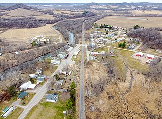
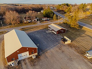
Ettrick is a village in Trempealeau County, Wisconsin, United States. The population was 525 at the 2020 census. The village is surrounded by the Town of Ettrick.

<span class="mw-page-title-main">Ettrick (town), Wisconsin</span> Town in Wisconsin, United States

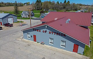
Ettrick is a town in Trempealeau County, Wisconsin. The population was 1,284 at the time of the 2000 census. The town surrounds the village of Ettrick. The unincorporated communities of Beaches Corners, Chapultepee, Hegg, Iduna, and Upper French Creek are also located in the town.

<span class="mw-page-title-main">Trempealeau, Wisconsin</span> Village in Wisconsin, United States

Trempealeau is a village located along the Mississippi River in Trempealeau County in the U.S. state of Wisconsin. The population was 1,843 at the 2020 census. The village is surrounded by the Town of Trempealeau.

Trempealeau is a town in Trempealeau County, Wisconsin, United States. The population was 1,618 at the 2000 census. The town surrounds the village of Trempealeau. The unincorporated communities of Centerville, West Prairie, and Wrights Corners are in the town.

<span class="mw-page-title-main">Arcadia, Wisconsin</span> City in Wisconsin, United States

Arcadia is a city in Trempealeau County, Wisconsin, United States, along the Trempealeau River. The population was 3,737 at the 2020 census. Arcadia is a Latino-majority city and the largest city in Trempealeau county.

References

  1. "2019 U.S. Gazetteer Files". United States Census Bureau. Retrieved August 7, 2020.
  2. 1 2 "US Board on Geographic Names". United States Geological Survey. October 25, 2007. Retrieved January 31, 2008.
  3. 1 2 "U.S. Census website". United States Census Bureau . Retrieved November 18, 2012.
  4. 1 2 "U.S. Census website". United States Census Bureau . Retrieved January 31, 2008.
  5. "Find a County". National Association of Counties. Retrieved June 7, 2011.
  6. Franklyn Curtiss-Wedge, Eben Douglas Pierce (1917). History of Trempealeau County Wisconsin. Unigraphic. p.  93.
  7. "Trempealeau County". Jim Forte Postal History. Retrieved April 2, 2015.
  8. Chicago and North Western Railway Company (1908). A History of the Origin of the Place Names Connected with the Chicago & North Western and Chicago, St. Paul, Minneapolis & Omaha Railways. p. 164.
  9. Franklyn Curtiss-Wedge, Eben Douglas Pierce (1917). History of Trempealeau County Wisconsin. Unigraphic. pp.  235–236.
  10. "US Gazetteer files 2010". United States Census Bureau . Retrieved November 18, 2012.
  11. "Census of Population and Housing". Census.gov. Retrieved February 15, 2023.