Stevens Point, Wisconsin

Last updated

Stevens Point, Wisconsin
Matthias Mitchell public square Stevens Point.jpg
Town square
Nickname(s): 
Gateway to the Pineries, City of Wonderful Water
Portage County Wisconsin Incorporated and Unincorporated areas Stevens Point Highlighted.svg
Location of Stevens Point in Portage County, Wisconsin.
USA Wisconsin relief location map.svg
Red pog.svg
Stevens Point
Usa edcp relief location map.png
Red pog.svg
Stevens Point
Coordinates: 44°31′23″N89°33′37″W / 44.52306°N 89.56028°W / 44.52306; -89.56028
CountryFlag of the United States.svg  United States
State Flag of Wisconsin.svg  Wisconsin
County Portage
Government
   Mayor Mike Wiza
Area
[1]
   City 18.41 sq mi (47.68 km2)
  Land17.17 sq mi (44.47 km2)
  Water1.24 sq mi (3.21 km2)
Elevation
1,089 ft (332 m)
Population
 (2020) [2]
   City 25,666
  Density1,495.1/sq mi (577.3/km2)
   Metro
70,377
Time zone UTC−6 (CST)
  Summer (DST) UTC−5 (CDT)
Zip code(s)
54481, 54482
Area code(s) 715 & 534
FIPS code 55-77200 [3]
GNIS feature ID1574878 [4]
Website stevenspoint.com

Stevens Point is a city in and the county seat of Portage County, Wisconsin, United States. [5] Its population was 25,666 as of the 2020 census. [6] It forms the core of the Stevens Point micropolitan statistical area, which had a population of 70,377 in 2020. [7]

Contents

The city was incorporated in 1858. Stevens Point is home to the University of Wisconsin–Stevens Point and a campus of Mid-State Technical College.

History

Historically part of the Menominee homelands, a three-mile strip along the Wisconsin River was ceded to the United States in an 1836 treaty. In 1854 the Menominee made its last treaty with the U.S., gathering on a reservation on the Wolf River. In the Menominee language it is called Pasīpahkīhnen which means "It juts out as land" or "point of land". [8]

Stevens Point was named after George Stevens, who operated a grocery and supply business on the Wisconsin River during the extensive logging of interior Wisconsin. The river was used by logging companies to float logs to market. Loggers on the river found this a convenient stopping point, as the river bends slightly and the operation was from far upstream. The town developed from Stevens's post and was named for him. [9]

In 1845, the postal service came to Stevens Point and with this improvement in communications, the population tripled within 20 years.

In 1847, the first plat was laid out of what became the City of Stevens Point, including the Public Square. The town square was originally an area next to the Wisconsin River where professionals, craftsmen, businessmen, and loggers gathered before their river journeys, bringing revenue to the area. As years went by, the area around the town square grew as logging increased.

Most buildings were first built with readily available wood. Many cases of early fires were reported from 18501890. Around 1880, buildings began to be built of brick and sandstone.

In 1916, Lyric Theater was built. It was demolished later.

Geography

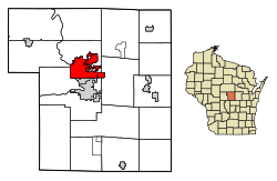
According to the United States Census Bureau, the city encompasses 18.41 square miles (47.7 km2), including 17.17 square miles (44.5 km2) of land 1.24 square miles (3.2 km2) of water. [10] The communities of Plover, Whiting and Park Ridge are adjacent to the city. The city's main hydrology includes the Wisconsin River to the west and the Plover River, which joins the Wisconsin from the northeast at a point to the south, and which supplies much of the urban area's water.

Climate

Climate data for Stevens Point, Wisconsin, 1991–2020 normals, extremes 1893present
MonthJanFebMarAprMayJunJulAugSepOctNovDecYear
Record high °F (°C)55
(13)
62
(17)
82
(28)
90
(32)
104
(40)
104
(40)
108
(42)
102
(39)
99
(37)
94
(34)
78
(26)
62
(17)
108
(42)
Mean maximum °F (°C)42.5
(5.8)
48.2
(9.0)
63.0
(17.2)
76.3
(24.6)
84.3
(29.1)
88.5
(31.4)
89.8
(32.1)
88.3
(31.3)
84.8
(29.3)
76.9
(24.9)
61.2
(16.2)
47.3
(8.5)
92.0
(33.3)
Mean daily maximum °F (°C)23.6
(−4.7)
28.1
(−2.2)
40.0
(4.4)
53.6
(12.0)
66.5
(19.2)
75.8
(24.3)
79.7
(26.5)
77.8
(25.4)
70.2
(21.2)
56.9
(13.8)
41.7
(5.4)
29.0
(−1.7)
53.6
(12.0)
Daily mean °F (°C)15.3
(−9.3)
18.7
(−7.4)
30.4
(−0.9)
43.1
(6.2)
55.9
(13.3)
65.7
(18.7)
69.8
(21.0)
67.9
(19.9)
59.8
(15.4)
47.1
(8.4)
33.7
(0.9)
21.6
(−5.8)
44.1
(6.7)
Mean daily minimum °F (°C)7.1
(−13.8)
9.3
(−12.6)
20.8
(−6.2)
32.7
(0.4)
45.2
(7.3)
55.6
(13.1)
59.8
(15.4)
57.9
(14.4)
49.5
(9.7)
37.3
(2.9)
25.6
(−3.6)
14.2
(−9.9)
34.6
(1.4)
Mean minimum °F (°C)−14.7
(−25.9)
−11.1
(−23.9)
−0.4
(−18.0)
19.7
(−6.8)
30.9
(−0.6)
42.8
(6.0)
49.8
(9.9)
47.4
(8.6)
35.4
(1.9)
24.6
(−4.1)
9.8
(−12.3)
−7.0
(−21.7)
−18.3
(−27.9)
Record low °F (°C)−37
(−38)
−48
(−44)
−31
(−35)
0
(−18)
14
(−10)
26
(−3)
38
(3)
31
(−1)
13
(−11)
6
(−14)
−13
(−25)
−32
(−36)
−48
(−44)
Average precipitation inches (mm)1.21
(31)
1.11
(28)
1.80
(46)
3.37
(86)
4.08
(104)
5.00
(127)
3.82
(97)
3.79
(96)
3.62
(92)
2.73
(69)
1.90
(48)
1.54
(39)
33.97
(863)
Average snowfall inches (cm)11.6
(29)
11.5
(29)
6.9
(18)
4.2
(11)
0.0
(0.0)
0.0
(0.0)
0.0
(0.0)
0.0
(0.0)
0.0
(0.0)
0.3
(0.76)
1.9
(4.8)
12.3
(31)
48.7
(123.56)
Average precipitation days (≥ 0.01 in)9.68.49.211.512.212.211.010.010.910.88.810.0124.6
Average snowy days (≥ 0.1 in)9.07.14.32.00.00.00.00.00.00.43.17.933.8
Source 1: NOAA [11]
Source 2: National Weather Service [12]

Demographics

Historical population
CensusPop.Note
1860 1,538
1870 1,89523.2%
1880 4,445134.6%
1890 7,89677.6%
1900 9,52420.6%
1910 8,692−8.7%
1920 11,37130.8%
1930 13,62319.8%
1940 15,77715.8%
1950 16,5645.0%
1960 17,8377.7%
1970 23,47931.6%
1980 22,970−2.2%
1990 23,0060.2%
2000 24,5516.7%
2010 26,7178.8%
2020 25,666−3.9%
source: [13]

2020 census

As of the census of 2020, [2] the population was 25,666. The population density was 1,495.1 inhabitants per square mile (577.3/km2). There were 11,386 housing units at an average density of 663.2 per square mile (256.1/km2). The racial makeup of the city was 85.6% White, 4.8% Asian, 2.7% Black or African American, 0.6% Native American, 1.3% from other races, and 4.9% from two or more races. Ethnically, the population was 4.1% Hispanic or Latino of any race.

The 2020 census population of the city included 40 people incarcerated in adult correctional facilities and 2,595 people in student housing. [14]

According to American Community Survey estimates for 2016-20, the median income for a household in the city was $46,663, and the median income for a family was $73,009. Male full-time workers had a median income of $48,618 versus $32,409 for female workers. The per capita income was $26,127. About 7.0% of families and 19.3% of the population were below the poverty line, including 11.4% of those under 18 and 8.6% of those 65 or older. [15] Of the population 25 and older, 93.4% were high school graduates or higher and 38.1% had a bachelor's degree or higher. [16]

2010 census

As of the 2010 census [17] 26,717 people, 10,598 households, and 4,944 families residing in the city. The population density was 1,674.0 inhabitants per square mile (646.3/km2). They occupied 11,220 housing units at an average density of 703.0 per square mile (271.4/km2). The racial makeup of the city was 91.7% White, 0.9% African American, 0.4% Native American, 4.7% Asian, 0.7% from other races, and 1.5% from two or more races. Hispanic or Latino of any race was 2.6% of the population.

Among households, 21.7% had children under the age of 18, 34.9% were married couples living together, 8.5% had a female householder with no husband present, 3.2% had a male householder with no wife present, and 53.3% were non-families. 34.9% of all households were made up of individuals, and 11.2% had someone living alone who was 65 years of age or older. The average household size was 2.21 and the average family size was 2.87.

The median age in the city was 26.5 years. 16% of residents were under the age of 18; 31.3% were between the ages of 18 and 24; 22.3% were from 25 to 44; 18.5% were from 45 to 64; and 12% were 65 years of age or older. The gender makeup of the city was 48.8% male and 51.2% female.

Religion

The mother house of the Sisters of St. Joseph of the Third Order of St. Francis was in Stevens Point. [18] Catholic parishes in the city include Holy Spirit, St. Stephen, St. Casimir, St. Peter, and St. Joseph. Lutheran and other Protestant churches are also present, along with members of the Baháʼí Faith.

A wide variety of Catholic and Protestant churches spread throughout Stevens Point. Many of those churches date back to the early 20th century. Within the past century, other religious groups have made their mark on Stevens Point. [19] [20] [ failed verification ] [21]

Economy

Major employers in the area include Pixelle Specialty Solutions paper mill, Associated Banc-Corp, Sentry Insurance, Travel Guard (travel and insurance), Donaldson Company, Skyward (software design), Lands' End, Canadian National Railway, Delta Dental of Wisconsin, Worzalla Publishing, Mason Companies (formerly known as Figis), Berkshire Hathaway Travel Protection, Herrschners, and the Stevens Point Brewery.

Companies with corporate headquarters in the city include Sentry Insurance, Ki Mobility, Delta Dental of Wisconsin, and Skyward. Associated Bank, Canadian National, AIG, and the Donaldson Company have regional headquarters in Stevens Point.

Business developments in the area include Crossroads Commons, Portage County Business Park, Venture Drive and Corporate Center, Stevens Point Industrial Park, Eastridge, Parkdale Plazas, Stevens Points East Side and Downtown Stevens Point.

At one time, Midstate Airlines had its headquarters in Stevens Point. [22]

Arts and culture

Stevens Point is home to a community theater group, Central Wisconsin Area Community Theatre (cwACT); a children's museum; and a group of museums run by the Portage County Historical Society, including the Beth Israel Congregation Museum, in the former synagogue. (The synagogue has been defunct since 1985.) [23]

Religion plays a significant role in the community. In 1847, the first recorded religious service was held near the town square with a pastor from Norway. As time went by, more religions joined the town square, and by 1900, Catholic, Lutheran, and Methodist churches and Jewish synagogues were established within one mile of the downtown area.

The Central Wisconsin Symphony Orchestra (CWSO) presents four concerts each season. [24]

Most events happen near the downtown area, many at the town square, which was rebuilt in 2011. These include the annual Riverfront Rendezvous, Corn on the Curb, sculpture park summer celebration, Fourth of July parade, Krazy Days and Gather at the River. [25]

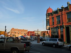
The downtown area was designated a "Wisconsin Main Street Community" and offers specialty shops and restaurants. Buildings in downtown Stevens Point are made from materials including Lake Superior limestone, brick, and red granite. City and county administrative offices are downtown, as are a bank regional headquarters and two insurance companies. Downtown also offers night life on "the Square" that is popular with college students and a farmers' market that has been selling fresh produce for over 100 years. The farmers' market is open early summer through early fall.

Stevens Point hosts the world's largest trivia contest, run by UWSP's radio station, WWSP-FM. The contest, which typically involves over 12,000 contestants on more than 400 teams, is held every year in April and lasts 54 consecutive hours, from Friday to Sunday.

The city was the setting for the first three seasons of the Disney Channel series Liv and Maddie . [26]

Parks and recreation

The area hosts 20 developed parks and a 26-mile (42 km) bicycle and jogging trail (the Green Circle Trail) that surrounds and winds through the city. [27] The Ice Age National Scenic Trail also runs through the city. An 18-hole Robert Trent Jones, Jr.-designed golf course and country club, SentryWorld, is at the Sentry Insurance Home Office. The Schmeeckle Reserve, a nature reserve, is on the University of Wisconsin–Stevens Point campus. Right outside of Schmeeckle is the Stevens Point Sculpture Park, which displays sculpture by local artists.

The area also has Goerke Park, which includes a football stadium where high school and college athletes compete. An outdoor track is used by the same groups.

The Backwaters Paddle Quest canoe adventure challenge has been held in Stevens Point on the Wisconsin River since 2002, usually during the second week of August. [28] Players paddle their crafts over two days past checkpoints along the river, encountering characters who act out a storyline that continues year to year.

Iverson Park is a recreational park course that lies on the green circle trail and Plover River in Stevens Point. It spans over 100 acres, and contains a swimming area, hiking trails, and canoe and recreation activities rental. [29]

Education

UniversityWisconsinStevensPointSign.jpg

The Stevens Point Area Public School District serves the city, [30] as do the Pacelli Catholic Schools and Point of Discovery School.

Public elementary schools include Bannach, Jefferson School for the Arts, Kennedy, Madison, McDill, McKinley, Roosevelt, Plover-Whiting, and Washington Service-Learning Center. There are two junior high schools, Ben Franklin and P. J. Jacobs, and two high schools, Stevens Point Area Senior High (SPASH) and Charles F. Fernandez Center for Alternative Learning.

Parochial schools include St. Paul Lutheran School (Pre-K–8), St. Joseph Early Childhood Center, St. Stanislaus (K–2) and St. Stephen Elementary (3–5) Schools, St. Peter Middle School, and Pacelli High School. [31] [32]

The city serves as the hub of the Portage County Public Library, which provides educational resources and programming for adults, young adults, and children.

Stevens Point is home to the University of Wisconsin–Stevens Point (UWSP). The university enrolls approximately 9,500 students in undergraduate and graduate degree programs. Mid-State Technical College (MSTC) is also in the city.

Transportation

A Soo Line Railroad train passing through Stevens Point in 1964 SOO GP30 702 at Stevens Point, WI in October 1964 (34347357011).jpg
A Soo Line Railroad train passing through Stevens Point in 1964

Major highways

Five major roads pass through Stevens Point:

Airport

The city is served by two airports. Commercial service is available through Central Wisconsin Airport (KCWA), midway between Stevens Point and Wausau, in Mosinee. CWA is served by three major airlines. General aviation, charter flights and air cargo operators use the local Stevens Point Municipal Airport (KSTE).

Public transit

Stevens Point Transit system provides public transportation.

Notable people

Sister cities

See also

Related Research Articles

<span class="mw-page-title-main">Shawano County, Wisconsin</span> County in Wisconsin, United States

Shawano County is a county located in the U.S. state of Wisconsin. As of the 2020 census, the population was 40,881. Its county seat is Shawano.

<span class="mw-page-title-main">Portage County, Wisconsin</span> County in Wisconsin, United States

Portage County is a county in the U.S. state of Wisconsin. As of the 2020 census, the population was 70,377. Its county seat is Stevens Point.

<span class="mw-page-title-main">Marathon County, Wisconsin</span> County in Wisconsin, United States

Marathon County is a county located in the U.S. state of Wisconsin. As of the 2020 census, the population was 138,013. Its county seat is Wausau. It was founded in 1850, created from a portion of Portage County. At that time the county stretched to the northern border with the upper Michigan peninsula. It is named after the battlefield at Marathon, Greece.

<span class="mw-page-title-main">Menominee County, Michigan</span> County in Michigan, United States

Menominee County is a county located in the Upper Peninsula in the U.S. state of Michigan. As of the 2020 census, the population was 23,502. The county seat is Menominee. The county's name comes from an American Indian word meaning "wild rice eater" used to describe a tribe. The county was created in 1861 from area partitioned out of Delta County, under the name of Bleeker. When county government was organized in 1863, the name was changed to Menominee.

<span class="mw-page-title-main">Menominee, Michigan</span> City in and the county seat of Menominee County, Michigan, United States

Menominee is a city and the county seat of Menominee County, Michigan in the Upper Peninsula. The population was 8,488 at the 2020 census. It is the county seat of Menominee County. Menominee is the fourth-largest city in the Upper Peninsula, behind Marquette, Sault Ste. Marie, and Escanaba. Menominee Township is located to the north of the city, but is politically autonomous.

<span class="mw-page-title-main">Portage, Wisconsin</span> City in Wisconsin, United States

Portage is a city in and the county seat of Columbia County, Wisconsin, United States. The population was 10,581 at the 2020 census, making it the largest city in Columbia County. The city is part of the Madison Metropolitan Statistical Area.

<span class="mw-page-title-main">Marinette, Wisconsin</span> City in Wisconsin, United States

Marinette is a city in and the county seat of Marinette County, Wisconsin, United States. It is located on the south bank of the Menominee River, at its mouth at Green Bay, part of Lake Michigan; to the north is Stephenson Island, part of the city preserved as park. During the lumbering boom of the late 19th century, Marinette became the tenth-largest city in Wisconsin in 1900, reaching a peak population of 16,195.

<span class="mw-page-title-main">Shiocton, Wisconsin</span> Village in Wisconsin, United States

Shiocton is a village in Outagamie County, Wisconsin, United States. The population was 921 at the 2010 census. It is wholly surrounded by the Town of Bovina.

<span class="mw-page-title-main">Marshfield, Wisconsin</span> City in Wisconsin, United States

Marshfield is in Wood and Marathon counties in the state of Wisconsin. It is located at the intersection of U.S. Highway 10, Highway 13 and Highway 97. The largest city in Wood County, its population was 18,929 at the 2020 census. Of this, 18,119 were in Wood County, and 810 were in Marathon County. The city is part of the United States Census Bureau's Marshfield-Wisconsin Rapids Micropolitan Statistical Area, which includes all of Wood County. The portion of the city in Marathon County is part of the Wausau Metropolitan Statistical Area.

<span class="mw-page-title-main">Appleton, Wisconsin</span> City in Wisconsin, United States

Appleton is a city in and the county seat of Outagamie County, Wisconsin, United States. A small portion of the city also extends into Calumet and Winnebago counties. It is situated on the Fox River, 30 miles (48 km) southwest of Green Bay and 100 miles (160 km) north of Milwaukee. As of the 2020 census, it had a population of 75,644, making it the sixth-most populous city in Wisconsin. Appleton is part of the Fox Cities metropolitan area, the third-largest metro area in the state with over 415,000 residents.

<span class="mw-page-title-main">New London, Wisconsin</span> City in Wisconsin, United States

New London is a city in Outagamie and Waupaca counties Wisconsin, United States. Founded in 1851, the population was 7,295 at the 2010 census. Of this, 5,685 were in Waupaca County, and 1,640 were in Outagamie County.

<span class="mw-page-title-main">Oconto, Wisconsin</span> City in Wisconsin, United States

Oconto is a city and county seat of Oconto County, Wisconsin, United States. The population was 4,609 at the 2020 census. It is part of the Green Bay Metropolitan Statistical Area. The city is located partially within the town of Oconto.

<span class="mw-page-title-main">Kaukauna, Wisconsin</span> City in Wisconsin, United States

Kaukauna is a city in Outagamie and Calumet counties, Wisconsin, United States. It is situated on the Fox River, approximately 100 miles (160 km) north of Milwaukee. The population was 17,089 at the 2020 census. It is a part of the Appleton, Wisconsin Metropolitan Statistical Area.

Plover is a town in Portage County, Wisconsin, United States. As of December 2020 the town reported on its website a population of 1,731.

<span class="mw-page-title-main">Plover, Wisconsin</span> Village in Wisconsin, United States

Plover is a village in Portage County, Wisconsin, United States. A suburb of Stevens Point, it is part of the Stevens Point Micropolitan Statistical Area. The population was 13,519 at the 2020 United States census.

<span class="mw-page-title-main">Weyauwega, Wisconsin</span> City in Wisconsin, United States

Weyauwega is a city in Waupaca County, Wisconsin, United States. The population was 1,900 at the 2010 census. The city is located mostly within the Town of Weyauwega, though it is politically independent of the town. Small portions extend north into the adjacent Town of Royalton. The city is commonly referred to as "Wega" by local residents. The name "Weyauwega" is described by the Weyauwega Chamber of Commerce as potentially meaning "Here we rest" in a local indigenous language because the town's origin was a stopping/resting point between two rivers when Native Americans had to portage their canoes. Given the local indigenous culture is described as Menominee the language may be the Menominee language if this etymology for Weyauwega is correct.

<span class="mw-page-title-main">Oshkosh, Wisconsin</span> City in Wisconsin, United States

Oshkosh is a city in and the county seat of Winnebago County, Wisconsin, United States. The city had a population of 66,816 in 2020, making it the ninth-most populous city in Wisconsin. It is also adjacent to the much less populous Town of Oshkosh in the north.

<span class="mw-page-title-main">Sturgeon Bay, Wisconsin</span> City in Wisconsin, United States

Sturgeon Bay is a city in and the county seat of Door County, Wisconsin, United States. The population was 9,646 at the 2020 census. Located at the bay of Sturgeon Bay for which it is named, it is the most-populous city on the Door Peninsula, a popular Upper Midwest vacation destination.

<span class="mw-page-title-main">Geography of Wisconsin</span> Physical features of the state in the Midwestern United States

Wisconsin, a state in the Midwestern United States, has a vast and diverse geography famous for its landforms created by glaciers during the Wisconsin glaciation 17,000 years ago. The state can be generally divided into five geographic regions—Lake Superior Lowland, Northern Highland, Central Plain, Eastern Ridges & Lowlands, and Western Upland. The southwestern part of the state, which was not covered by glaciers during the most recent ice age, is known as the Driftless Area. The Wisconsin glaciation formed the Wisconsin Dells, Devil's Lake, and the Baraboo Range. A number of areas are protected in the state, including Devil's Lake State Park, the Apostle Islands National Lakeshore, and the Chequamegon–Nicolet National Forest.

Bancroft is an unincorporated census-designated place in Portage County, Wisconsin, United States. As of the 2010 census, its population is 535. It is included in the Stevens Point, Wisconsin Micropolitan Statistical Area.

References

  1. "2019 U.S. Gazetteer Files". United States Census Bureau. Retrieved August 7, 2020.
  2. 1 2 "2020 Decennial Census: Stevens Point city, Wisconsin". data.census.gov. U.S. Census Bureau. Retrieved July 18, 2022.
  3. "U.S. Census website". United States Census Bureau . Retrieved January 31, 2008.
  4. "US Board on Geographic Names". United States Geological Survey. October 25, 2007. Retrieved January 31, 2008.
  5. "Find a County". National Association of Counties. Archived from the original on May 31, 2011. Retrieved June 7, 2011.
  6. "American FactFinder". Factfinder.census.gov. Archived from the original on February 10, 2020. Retrieved March 29, 2013.
  7. "2020 Decennial Census: Stevens Point WI, Micro Area". data.census.gov. U.S. Census Bureau. Retrieved July 18, 2022.
  8. Hoffman, Mike. "Menominee Place Names in Wisconsin". The Menominee Clans Story. Retrieved October 6, 2018.
  9. Archived January 2, 2016, at the Wayback Machine
  10. "2020 Gazetteer Files". census.gov. U.S. Census Bureau. Retrieved July 18, 2022.
  11. "U.S. Climate Normals Quick Access – Station: Stevens PT, WI". National Oceanic and Atmospheric Administration. Retrieved March 5, 2023.
  12. "NOAA Online Weather Data – NWS Green Bay". National Weather Service. Retrieved March 5, 2023.
  13. Quickfacts.census.gov Archived April 18, 2012, at the Wayback Machine - Stevens Point, WI - accessed 2012-03-07
    City of Stevens Point Comprehensive Plan 2005 Archived April 27, 2012, at the Wayback Machine - Population and housing methodologies - Appendix D, p.2 - accessed 2012-03-07
    Portage County Historical Society of Wisconsin Archived May 1, 2021, at the Wayback Machine - county time line, 1827 thru 1998 - accessed 2012-03-07
  14. "Group Quarters Population, 2020 Census: Stevens Point city, Wisconsin". data.census.gov. U.S. Census Bureau. Retrieved December 21, 2022.
  15. "Selected Economic Characteristics, 2020 American Community Survey: Stevens Point city, Wisconsin". data.census.gov. U.S. Census Bureau. Retrieved December 21, 2022.
  16. "Selected Social Characteristics, 2020 American Community Survey: Stevens Point city, Wisconsin". data.census.gov. U.S. Census Bureau. Retrieved December 21, 2022.
  17. "U.S. Census website". United States Census Bureau . Retrieved November 18, 2012.
  18. NEWS, STEVENS POINT (January 16, 2019). "Sisters of St. Joseph of the Third Order of St. Francis leaving Stevens Point after over 100 years of service". Stevens Point News. Retrieved September 17, 2022.
  19. Bratz, Mary (June 28, 2006). "Love, unity, forgiveness govern the relationship of God's creatures". Stevens Point (Wisconsin) Journal. Archived from the original on May 18, 2009. Retrieved August 6, 2008.
  20. Stokes, Jim (Spring 1997). "The Story of Joseph in Five Religious Traditions". World Order. 28 (3): 35–46.
  21. Rowe, T. (June 2007). "T. Rowe, Ph.D". Faculty Webpage. UWSP Department of Psychology. Archived from the original on July 6, 2008. Retrieved August 6, 2008.
  22. "World Airline Directory." Flight International . March 30, 1985. 98. "Head Office: 3101 Dixon Street, Stevens Point, Wisconsin 54481, USA."
  23. "Portage County Historical Society". portage.oh.us. Retrieved September 20, 2015.
  24. Archived June 5, 2010, at the Wayback Machine
  25. "Portage County Cultural Festival~ Stevens Point, WI". Portagecountyculturalfestival.org. Retrieved March 29, 2013.
  26. "'Liv and Maddie' Executive Producers Talk Celebrating Wisconsin, Season 2 Premiere". The Pointer. University of Wisconsin–Stevens Point. September 19, 2014. Retrieved May 30, 2017.
  27. "Green Circle Trail". greencircletrail.org. Retrieved September 17, 2022.
  28. "Paddle Quest Challenges Nationwide Canoeists". Wsaw.com. August 8, 2009. Retrieved March 29, 2013.
  29. "Iverson Park". TravelWisconsin.
  30. "Stevens Point Area Public School District - District Home". Wisp.k12.wi.us. February 4, 2013. Retrieved March 29, 2013.
  31. St. Paul Online
  32. "SPACS General Brochure". Spacs.k12.wi.us. Retrieved March 29, 2013.
  33. 1 2 "Interactive City Directory". sister-cities.org. Archived from the original on September 24, 2015. Retrieved September 20, 2015.