Brown County, Wisconsin

Last updated

Brown County
Brown County Courthouse Aerial.jpg
Map of Wisconsin highlighting Brown County.svg
Location within the U.S. state of Wisconsin
Wisconsin in United States.svg
Wisconsin's location within the U.S.
Coordinates: 44°29′N87°59′W / 44.48°N 87.99°W / 44.48; -87.99
CountryFlag of the United States.svg United States
StateFlag of Wisconsin.svg  Wisconsin
Founded1818
Named for Jacob Brown
Seat Green Bay
Largest cityGreen Bay
Area
  Total616 sq mi (1,600 km2)
  Land530 sq mi (1,400 km2)
  Water86 sq mi (220 km2)  14%
Population
 (2020)
  Total268,740
  Density507.0/sq mi (195.8/km2)
Time zone UTC−6 (Central)
  Summer (DST) UTC−5 (CDT)
Congressional district 8th
Website www.browncountywi.gov

Brown County is a county in the U.S. state of Wisconsin. As of the 2020 census, the population was 268,740, [1] making it the fourth-most populous county in Wisconsin. The county seat is Green Bay. [2] Brown County is part of the Green Bay, WI Metropolitan Statistical Area.

Contents

History

Tourist's Pocket Map Of Michigan (Samuel Augustus Mitchell, 1835).jpg
Wisconsin Territory depicted on this 1835 Tourist's Pocket Map Of Michigan, showing a Menominee-filled Brown County, Wisconsin that spans the northern half of the territory.

Brown County is one of Wisconsin's two original counties, along with Crawford County. It originally spanned the entire eastern half of the state when formed by the Michigan Territorial legislature in 1818.[ citation needed ] It was named for Major General Jacob Brown, a military leader during the War of 1812. [3] [4]

Several towns along the Fox River vied for the position of county seat in Brown County's early years. The first county seat was located at Menomoneeville (now a part of Allouez) in 1824. In 1837, a public referendum relocated the county seat to De Pere. The location was put up for the popular vote again in 1854, resulting in the establishment of the present county seat at Green Bay. [5]

The oldest known tree in Wisconsin, a 1,300 year-old cedar growing on the Niagara Escarpment, was found in Brown County. [6]

Geography

According to the U.S. Census Bureau, the county has a total area of 616 square miles (1,600 km2), of which 530 square miles (1,400 km2) is land and 86 square miles (220 km2) (14%) is water. [7]

Major highways

Railroads

Buses

Climate

Brown County
Climate chart (explanation)
J
F
M
A
M
J
J
A
S
O
N
D
 
 
62
 
 
−8
−13
 
 
62
 
 
−6
−11
 
 
66
 
 
1
−8
 
 
141
 
 
16
1
 
 
105
 
 
20
7
 
 
106
 
 
24
14
 
 
108
 
 
28
16
 
 
88
 
 
27
15
 
 
72
 
 
22
12
 
 
121
 
 
12
5
 
 
68
 
 
5
−2
 
 
61
 
 
−5
−11
Average max. and min. temperatures in °C
Precipitation totals in mm
Source: [8]
Imperial conversion
JFMAMJJASOND
 
 
2.4
 
 
18
9
 
 
2.4
 
 
21
12
 
 
2.6
 
 
34
18
 
 
5.6
 
 
61
34
 
 
4.1
 
 
68
45
 
 
4.2
 
 
75
57
 
 
4.3
 
 
82
61
 
 
3.5
 
 
81
59
 
 
2.8
 
 
72
54
 
 
4.8
 
 
54
41
 
 
2.7
 
 
41
28
 
 
2.4
 
 
23
12
Average max. and min. temperatures in °F
Precipitation totals in inches

Demographics

In 2017, there were 3,324 births, giving a general fertility rate of 65.6 births per 1000 women aged 15–44, which is above the Wisconsin average of 60.1. [9] Additionally, there were 168 reported induced abortions performed on women of Brown County residence, with a rate of 3.3 abortions per 1000 women aged 15–44, which is below the Wisconsin average rate of 5.2. [10]

Historical population
CensusPop.Note
1840 2,107
1850 6,215195.0%
1860 11,79589.8%
1870 25,168113.4%
1880 34,07835.4%
1890 39,16414.9%
1900 46,35918.4%
1910 54,09816.7%
1920 61,88914.4%
1930 70,24913.5%
1940 83,10918.3%
1950 98,31418.3%
1960 125,08227.2%
1970 158,24426.5%
1980 175,28010.8%
1990 194,59411.0%
2000 226,77816.5%
2010 248,0079.4%
2020 268,7408.4%
U.S. Decennial Census [11]
1790–1960 [12] 1900–1990 [13]
1990–2000 [14] 2010–2020 [1]

2020 census

As of the census of 2020, [15] the population was 268,740. The population density was 507.0 people per square mile (195.8 people/km2). There were 112,908 housing units at an average density of 213.0 units per square mile (82.2 units/km2). The racial makeup of the county was 79.2% White, 3.2% Asian, 3.1% Black or African American, 2.8% Native American, 4.4% from other races, and 7.2% from two or more races. Ethnically, the population was 9.8% Hispanic or Latino of any race.

2010 census

At the 2010 census there were 248,007 people, 98,383 households, and 63,721 families living in the county. The population density was 403 people per square mile (156 people/km2). There were 104,371 housing units at an average density of 170 units per square mile (66 units/km2). The racial makeup of the county was 86.5% White, 2.2% Black or African American, 2.7% Native American, 2.7% Asian, 0.0004% Pacific Islander, 3.7% from other races, and 2.2% from two or more races. 7.3% of the population were Hispanic or Latino of any race. [16] Of the 98,383 households 31.0% had children under the age of 18 living with them, 50.0% were married couples living together, 10.2% had a female householder with no husband present, and 35.2% were non-families. 27.7% of households were one person and 8.9% were one person aged 65 or older. The average household size was 2.45 and the average family size was 3.02.

The age distribution was 24.1% under the age of 18, 10.8% from 18 to 24, 26.9% from 25 to 44, 26.6% from 45 to 64, and 11.6% 65 or older. The median age was 36.2 years. For every 100 females, there were 97.80 males. For every 100 females age 18 and over, there were 95.70 males.

2000 census

2000 Census Age Pyramid for Brown County USA Brown County, Wisconsin age pyramid.svg
2000 Census Age Pyramid for Brown County

At the 2000 census there were 226,778 people, 87,295 households, and 57,527 families living in the county. The population density was 429 people per square mile (166 people/km2). There were 90,199 housing units at an average density of 171 units per square mile (66 units/km2). The racial makeup of the county was 91.14% White, 1.16% Black or African American, 2.29% Native American, 2.18% Asian, 0.03% Pacific Islander, 1.90% from other races, and 1.30% from two or more races. 3.84% of the population were Hispanic or Latino of any race. 33.8% were of German, 8.9% Polish, 7.8% Belgian and 6.8% Irish ancestry. 93.2% spoke only English at home, 3.8% spoke Spanish and 1.2% Hmong. [16] Of the 87,295 households 33.90% had children under the age of 18 living with them, 53.20% were married couples living together, 8.90% had a female householder with no husband present, and 34.10% were non-families. 26.50% of households were one person and 8.40% were one person aged 65 or older. The average household size was 2.51 and the average family size was 3.08.

The age distribution was 26.10% under the age of 18, 10.50% from 18 to 24, 31.90% from 25 to 44, 20.90% from 45 to 64, and 10.70% 65 or older. The median age was 34 years. For every 100 females, there were 98.90 males. For every 100 females age 18 and over, there were 96.90 males.

Government

The legislative branch of Brown County is the 26-member Board of Supervisors. Each member represents a single district and serves a two-year term, with elections held in the spring of even-numbered years. The Board of Supervisors elects a Chairman and Vice Chairman from its membership.

The executive branch of Brown County is the County Executive, who is elected in the spring of every other odd-numbered year. The executive appoints department heads with the approval of the County Board. The current county executive is Troy Streckenbach.

Brown County has several other elected officials that are established under the Wisconsin State constitution and are referred to as the "constitutional officers". Constitutional officers are the only partisan elected officials within Brown County government, as the Executive and County Board are non-partisan positions.

The current constitutional officers are:

In July 2002, the county declared English its official language, voting 17–8 to do so and to increase spending to promote fluency in English.

Communities

Brown County Veterans Memorial Arena BrownCountyArenaMay2007.jpg
Brown County Veterans Memorial Arena
Farmland in rural Brown County BrownCountyWisconsinBarnFarmlandSpringWIS96.jpg
Farmland in rural Brown County
The County Executive Troy Streckenbach, Brown County Neville Museum Director, and Mayor Jim Schmitt of Green Bay in front of the dinosaur sculpture. Neville Public Museum Dinosaur Sculpture Re-dedication.JPG
The County Executive Troy Streckenbach, Brown County Neville Museum Director, and Mayor Jim Schmitt of Green Bay in front of the dinosaur sculpture.

Cities

Villages

Towns

Census-designated places

Unincorporated communities

Native American communities

Ghost towns/Neighborhoods

Adjacent counties

Brown County and adjacent counties, in the early morning of January 1, 2018, taken from the International Space Station ISS054-E-8026.jpg
Brown County and adjacent counties, in the early morning of January 1, 2018, taken from the International Space Station

Green Bay, center, is the seat of Brown County. The city of Oconto (half cut off at the bottom right) is the county seat of Oconto County. Slightly above and much further right of Oconto is Oconto Falls, also in Oconto County. The somewhat larger city above Oconto Falls is Pulaski, which is in Brown County at the very border with Shawano County. Shawano County extends between Pulaski and past the edge of the photograph.

The large city in the top right is Appleton, the county seat of Outagamie County. To the left of Appleton and across the northern edge of Lake Winnebago is Brillion in Calumet County.

The village directly to the left of Green Bay and its immediate suburbs is Denmark, in Brown County. The smaller communities above and slightly to the left of Denmark (including Cooperstown, Maribel, and Kellnersville) are in Manitowoc County.

Luxembourg (larger village in lower left) and Casco (half cut off at lower far left) are in Kewaunee County.

Politics

Since 1968, Brown County has voted for the Republican presidential candidate in all but two elections, 1996 and 2008. Democratic strength is concentrated in the city of Green Bay, while the suburban and rural areas typically vote Republican. [17]

United States presidential election results for Brown County, Wisconsin [18]
Year Republican Democratic Third party
No.%No.%No.%
2020 75,87152.68%65,51145.49%2,6351.83%
2016 67,21052.10%53,38241.38%8,4196.53%
2012 64,83650.29%62,52648.50%1,5661.21%
2008 55,85444.77%67,26953.92%1,6311.31%
2004 67,17354.48%54,93544.56%1,1860.96%
2000 54,25850.35%49,09645.56%4,4154.10%
1996 38,56342.45%42,82347.14%9,45110.40%
1992 42,35241.24%37,51336.53%22,83622.24%
1988 43,62550.75%41,78848.62%5400.63%
1984 51,20262.44%30,21836.85%5830.71%
1980 47,06756.72%29,79635.91%6,1147.37%
1976 36,57150.62%33,57246.47%2,1002.91%
1972 37,10156.49%26,51140.37%2,0633.14%
1968 30,13353.67%21,61538.50%4,3957.83%
1964 21,13440.59%30,85159.26%790.15%
1960 26,32949.72%26,57750.19%460.09%
1956 32,87870.24%13,64229.14%2880.62%
1952 30,40067.80%14,34231.99%940.21%
1948 17,72948.50%18,44950.47%3801.04%
1944 17,76250.14%17,57649.61%880.25%
1940 16,37945.45%19,52654.18%1350.37%
1936 8,43327.14%21,41768.92%1,2273.95%
1932 7,15025.87%19,99072.34%4941.79%
1928 9,37136.04%16,46563.32%1680.65%
1924 7,61137.90%2,32811.59%10,14150.50%
1920 8,84561.66%3,87727.03%1,62311.31%
1916 4,13240.02%5,77155.90%4214.08%
1912 2,76432.76%3,55742.16%2,11625.08%
1908 4,94755.25%3,35437.46%6537.29%
1904 6,02765.84%2,66729.13%4605.03%
1900 4,93456.80%3,58841.30%1651.90%
1896 5,43657.51%3,84140.64%1751.85%
1892 2,85542.41%3,65354.26%2243.33%

See also

Related Research Articles

<span class="mw-page-title-main">Winnebago County, Wisconsin</span> County in Wisconsin, United States

Winnebago County is a county in the U.S. state of Wisconsin. As of the 2020 census, the population was 171,730. Its county seat is Oshkosh. It was named for the historic Winnebago people, a federally recognized Native American tribe now known as the Ho-Chunk Nation. Chief Oshkosh was a Menominee leader in the area. Winnebago County comprises the Oshkosh-Neenah, WI Metropolitan Statistical Area, which is included in the Appleton-Oshkosh-Neenah, WI Combined Statistical Area.

<span class="mw-page-title-main">Waupaca County, Wisconsin</span> County in Wisconsin, United States

Waupaca County is a county in the U.S. state of Wisconsin. As of the 2020 census, the population was 51,812. The county seat is Waupaca. The county was created in 1851 and organized in 1853. It is named after the Waupaca River, a Menominee language name meaning 'white sand bottom', 'pale water', or 'tomorrow river'.

<span class="mw-page-title-main">Shawano County, Wisconsin</span> County in Wisconsin, United States

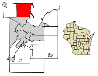
Shawano County is a county located in the U.S. state of Wisconsin. As of the 2020 census, the population was 40,881. Its county seat is Shawano.

<span class="mw-page-title-main">Outagamie County, Wisconsin</span> County in Wisconsin

Outagamie County is a county in the Fox Cities region of the U.S. state of Wisconsin, located in the northeast of the state. As of the 2020 Census, the population was 190,705. Its county seat is Appleton.

<span class="mw-page-title-main">Oconto County, Wisconsin</span> County in Wisconsin, United States

Oconto County is a county in the U.S. state of Wisconsin. As of the 2020 census, the population was 38,965. Its county seat is Oconto. The county was established in 1851.

<span class="mw-page-title-main">Menominee County, Wisconsin</span> County in Wisconsin, United States

Menominee County is a county in the U.S. state of Wisconsin. As of the 2020 census, the population was 4,255, making it the least populous county in Wisconsin. Its county seat is in the community of Keshena.

<span class="mw-page-title-main">Marinette County, Wisconsin</span> County in Wisconsin, United States

Marinette County is a county in the U.S. state of Wisconsin. As of the 2020 census, the population was 41,872. Its county seat is Marinette. Marinette County is part of the Marinette, WI–MI Micropolitan Statistical Area.

<span class="mw-page-title-main">Langlade County, Wisconsin</span> County in Wisconsin, United States

Langlade County is a county located in the U.S. state of Wisconsin. As of the 2020 census, the population was 19,491. Its county seat is Antigo.

<span class="mw-page-title-main">Pittsfield, Wisconsin</span> Town in Wisconsin, United States

Pittsfield is a town in Brown County in the U.S. state of Wisconsin. The population was 2,608 at the 2010 census.

<span class="mw-page-title-main">Suamico, Wisconsin</span> Village in Wisconsin, United States

Suamico is a village in Brown County in the U.S. state of Wisconsin. The population was 12,820 at the time of the 2020 census. Suamico is part of the Green Bay Metropolitan Statistical Area, and contains the neighborhood community of Flintville.

<span class="mw-page-title-main">Suring, Wisconsin</span> Village in Wisconsin, United States

Suring is a village in Oconto County, Wisconsin, United States, along the 45th parallel. The population was 544 at the 2010 census. It is part of the Green Bay Metropolitan Statistical Area.

<span class="mw-page-title-main">Cicero, Wisconsin</span> Town in Wisconsin, United States

Cicero is a town in Outagamie County, Wisconsin, United States. The population was 1,092 at the 2000 census.

<span class="mw-page-title-main">Grand Chute, Wisconsin</span> Town in Wisconsin, United States

Grand Chute is a town in Outagamie County, Wisconsin, United States. The population was 23,831 at the 2020 census. The unincorporated community of Apple Creek is partially located in the town. It was the birthplace of U.S. Senator Joseph McCarthy.

<span class="mw-page-title-main">Shawano, Wisconsin</span> City in Wisconsin, United States

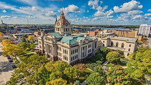
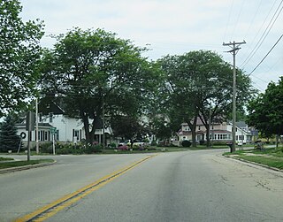
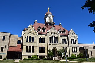
Shawano is a city in Shawano County, Wisconsin, United States. The population was 9,243 at the 2020 census. It is the county seat of Shawano County.

<span class="mw-page-title-main">Pulaski, Wisconsin</span> Village in Wisconsin, United States

Pulaski is a village in Brown, Oconto, and Shawano counties in the U.S. state of Wisconsin. The population was 3,539 at the 2010 census. Of this, 3,321 were in Brown County, 218 in Shawano County, and none in Oconto County.

<span class="mw-page-title-main">Wrightstown, Wisconsin</span> Village in Wisconsin, United States

Wrightstown is a village in Brown and Outagamie counties in the U.S. state of Wisconsin. The population was 2,827 at the 2010 census. Of this, 2,676 were in Brown County, and 151 were in Outagamie County. The village is surrounded mostly by the westernmost part of the Town of Wrightstown in Brown County. On February 28, 2002, the village annexed a portion of land within the adjacent Town of Kaukauna in Outagamie County.

<span class="mw-page-title-main">Gillett, Wisconsin</span> City in Wisconsin, United States

Gillett is a city in Oconto County, Wisconsin, United States. The population was 1,386 at the 2010 census. It is part of the Green Bay Metropolitan Statistical Area. The city is adjacent to the Town of Gillett.

<span class="mw-page-title-main">Lena, Wisconsin</span> Village in Wisconsin, United States

Lena is a village in Oconto County, Wisconsin, United States. The population was 564 at the 2010 census. It is part of the Green Bay Metropolitan Statistical Area. The village is located within the Town of Lena.

<span class="mw-page-title-main">Oconto, Wisconsin</span> City in Wisconsin, United States

Oconto is a city and county seat of Oconto County, Wisconsin, United States. The population was 4,609 at the 2020 census. It is part of the Green Bay Metropolitan Statistical Area. The city is located partially within the town of Oconto.

<span class="mw-page-title-main">Seymour, Wisconsin</span> City in Wisconsin, United States

Seymour is a city in Outagamie County, Wisconsin, United States. The population was 3,451 at the 2010 census. The city is located within the Town of Seymour and the Town of Osborn.

References

  1. 1 2 "State & County QuickFacts". United States Census Bureau. Archived from the original on June 6, 2011. Retrieved January 17, 2014.
  2. "Find a County". National Association of Counties. Archived from the original on May 31, 2011. Retrieved June 7, 2011.
  3. History of the Origin of the Place Names in Nine Northwestern States. 1908. p. 12.
  4. "Here's How Iron Got Its Name". The Rhinelander Daily News. June 16, 1932. p. 2. Retrieved August 24, 2014 via Newspapers.com. Open Access logo PLoS transparent.svg
  5. History of Northern Wisconsin, containing an account of its settlement, growth, development, and resources... Chicago: Western Historical Company. 1881. p. 103. Retrieved July 9, 2022.
  6. The oldest known tree in Wisconsin is a 1,300-year-old cedar growing from a cliff
  7. "2010 Census Gazetteer Files". United States Census Bureau. August 22, 2012. Retrieved August 2, 2015.
  8. "NASA Earth Observations Data Set Index". NASA. Archived from the original on November 28, 2017. Retrieved January 30, 2016.
  9. "Annual Wisconsin Birth and Infant Mortality Report, 2017 P-01161-19 (June 2019): Detailed Tables". Archived from the original on June 19, 2019. Retrieved June 19, 2019.
  10. Reported Induced Abortions in Wisconsin, Office of Health Informatics, Division of Public Health, Wisconsin Department of Health Services. Section: Trend Information, 2013-2017, Table 18, pages 17-18
  11. "U.S. Decennial Census". United States Census Bureau. Retrieved August 2, 2015.
  12. "Historical Census Browser". University of Virginia Library. Retrieved August 2, 2015.
  13. Forstall, Richard L., ed. (March 27, 1995). "Population of Counties by Decennial Census: 1900 to 1990". United States Census Bureau. Retrieved August 2, 2015.
  14. "Census 2000 PHC-T-4. Ranking Tables for Counties: 1990 and 2000" (PDF). United States Census Bureau. April 2, 2001. Archived (PDF) from the original on October 9, 2022. Retrieved August 2, 2015.
  15. "2020 Decennial Census: Brown County, Wisconsin". data.census.gov. U.S. Census Bureau. Retrieved July 2, 2022.
  16. 1 2 "U.S. Census website". United States Census Bureau . Retrieved May 14, 2011.
  17. BeMiller, Haley; Bollier, Jeff (November 4, 2020). "Green Bay pads Biden's lead in Wisconsin as Brown County overall goes for Trump". Green Bay Press Gazette. Retrieved December 5, 2020.
  18. Leip, David. "Dave Leip's Atlas of U.S. Presidential Elections". uselectionatlas.org. Retrieved November 9, 2020.

Further reading

44°29′N87°59′W / 44.48°N 87.99°W / 44.48; -87.99