New Denmark, Wisconsin

Last updated

New Denmark, Wisconsin
Brown County Wisconsin incorporated and unincorporated areas New Denmark highlighted.svg
Location in Brown County and the state of Wisconsin
Coordinates: 44°22′12″N87°50′7″W / 44.37000°N 87.83528°W / 44.37000; -87.83528
Country Flag of the United States.svg  United States
State Flag of Wisconsin.svg  Wisconsin
County Brown
Established1855
Area
  Total34.4 sq mi (89.1 km2)
  Land34.1 sq mi (88.4 km2)
  Water0.2 sq mi (0.6 km2)
Elevation
[1]
853 ft (260 m)
Population
 (2020)
  Total1,562
  Density45/sq mi (17.4/km2)
Time zone UTC-6 (Central (CST))
  Summer (DST) UTC-5 (CDT)
Area code 920
FIPS code 55-56575 [2]
GNIS feature ID1583803 [1]
Website townofnewdenmark.com
Town hall NewDenmarkWisconsinTownHall.jpg
Town hall

New Denmark is a town in Brown County in the U.S. state of Wisconsin. The population was 1,562 at the 2020 census. The town surrounds the village of Denmark but is separate from it. The unincorporated communities of Fontenoy and Langes Corners are located in the town. The unincorporated community of Buckman is also located partially in the town.

Contents

History

New Denmark was settled by Danish immigrants in 1848, making it the oldest Danish settlement in the United States. [3]

The Town of New Denmark had a post office called Cooperstown, which was later renamed "New Denmark". [4] Cooperstown is now part of Manitowoc County. On March 8, 1855, the Brown County Board of Supervisors split New Denmark off from the town of De Pere, creating the Town of New Denmark. [4]

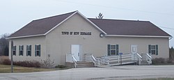
On June 15, 1915, the community of Denmark, the commercial center of the Town of New Denmark, held a special election on the issue of incorporation. [5] The official vote tally was 109 in favor, and 26 against. [5] Later that year, Denmark was officially incorporated into a village.

Geography

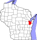
New Denmark is located in southeastern Brown County and is bordered by Manitowoc County to the south and Kewaunee County to the east. The town surrounds the village of Denmark, which is located south of the geographic center of the town.

According to the United States Census Bureau, the town has a total area of 34.4 square miles (89.1 km2), of which 34.1 square miles (88.4 km2) is land and 0.23 square miles (0.6 km2), or 0.72%, is water. [6]

Demographics

Historical population
CensusPop.Note
2000 1,482
2010 1,5414.0%
2020 1,5621.4%
U.S. Decennial Census [7]

As of the census [2] of 2000, there were 1,482 people, 515 households, and 417 families residing in the town. The population density was 42.7 people per square mile (16.5/km2). There were 528 housing units at an average density of 15.2 per square mile (5.9/km2). The racial makeup of the town was 98.58% White, 0.34% Native American, 0.61% Asian, 0.13% from other races, and 0.34% from two or more races. Hispanic or Latino of any race were 0.54% of the population.

There were 515 households, out of which 38.1% had children under the age of 18 living with them, 73.2% were married couples living together, 4.3% had a female householder with no husband present, and 19.0% were non-families. 17.3% of all households were made up of individuals, and 5.2% had someone living alone who was 65 years of age or older. The average household size was 2.87 and the average family size was 3.25.

In the town, the population was spread out, with 28.6% under the age of 18, 7.2% from 18 to 24, 29.0% from 25 to 44, 26.2% from 45 to 64, and 9.0% who were 65 years of age or older. The median age was 37 years. For every 100 females, there were 108.4 males. For every 100 females age 18 and over, there were 107.5 males.

The median income for a household in the town was $57,891, and the median income for a family was $61,750. Males had a median income of $40,804 versus $25,243 for females. The per capita income for the town was $23,313. About 1.7% of families and 4.3% of the population were below the poverty line, including 5.7% of those under age 18 and 7.2% of those age 65 or over.

Highways

Notable people

Related Research Articles

<span class="mw-page-title-main">Brown County, Wisconsin</span> County in Wisconsin, United States

Brown County is a county in the U.S. state of Wisconsin. As of the 2020 census, the population was 268,740, making it the fourth-most populous county in Wisconsin. The county seat is Green Bay. Brown County is part of the Green Bay, WI Metropolitan Statistical Area.

<span class="mw-page-title-main">Holland, Brown County, Wisconsin</span> Town in Wisconsin, United States

Holland is a town in Brown County in the U.S. state of Wisconsin. The population was 1,519 at the 2010 census. The unincorporated communities of Askeaton and Hollandtown are located in the town.

<span class="mw-page-title-main">Morrison, Wisconsin</span> Town in Wisconsin, United States

Morrison is a town in Brown County in the U.S. state of Wisconsin. The population was 1,599 at the 2010 census.

<span class="mw-page-title-main">Charlestown, Wisconsin</span> Town in Wisconsin, United States

Charlestown is a town in Calumet County in the U.S. state of Wisconsin. The population was 775 at the 2010 census. The unincorporated community of Hayton is located in the town.

<span class="mw-page-title-main">Rantoul, Wisconsin</span> Town in Wisconsin, United States

Rantoul is a town in Calumet County in the U.S. state of Wisconsin. The population was 798 at the 2010 census. The unincorporated community of Wells is located partially in the town.

<span class="mw-page-title-main">Ahnapee, Wisconsin</span> Town in Wisconsin, United States

Ahnapee is a town in Kewaunee County, Wisconsin, United States, on the Ahnapee River. The population was 940 as of the 2010 census. The Ahnapee State Trail passes through the town of Ahnapee.

<span class="mw-page-title-main">Franklin, Kewaunee County, Wisconsin</span> Town in Wisconsin, United States

Franklin is a town in Kewaunee County, Wisconsin, United States. The population was 993 at the 2010 census.

<span class="mw-page-title-main">Cato, Wisconsin</span> Town in Wisconsin, United States

Cato is a town in Manitowoc County, Wisconsin, United States. The population was 1,616 at the 2000 census. A Manitowoc County park is located in the town which is called "Cato Falls" for a waterfall on the Manitowoc River.

<span class="mw-page-title-main">Centerville, Manitowoc County, Wisconsin</span> Town in Wisconsin, United States

Centerville is a town in Manitowoc County, Wisconsin, United States. The population was 713 at the 2000 census. The town is divided by I-43 and surrounds the Village of Cleveland.

<span class="mw-page-title-main">Cooperstown, Wisconsin</span> Town in Wisconsin, United States

Cooperstown is a town in Manitowoc County, Wisconsin, in the United States. As of the 2000 census, the town population was 1,403.

<span class="mw-page-title-main">Kossuth, Wisconsin</span> Town in Wisconsin, United States

Kossuth is a town in Manitowoc County, Wisconsin, United States. The population was 2,033 at the 2000 census. The village of Francis Creek and the unincorporated community of Rockwood are located in the town. The unincorporated communities of Kingsbridge and Reifs Mills are also located partially in the town.

<span class="mw-page-title-main">Liberty, Manitowoc County, Wisconsin</span> Town in Wisconsin, United States

Liberty is a town in Manitowoc County, Wisconsin, United States. The population was 1,287 at the 2000 census.

<span class="mw-page-title-main">Manitowoc Rapids, Wisconsin</span> Town in Wisconsin, United States

Manitowoc Rapids is a town in Manitowoc County, Wisconsin, United States. The population was 2,520 at the 2000 census.

<span class="mw-page-title-main">Newton, Manitowoc County, Wisconsin</span> Town in Wisconsin, United States

Newton is a town in Manitowoc County, Wisconsin, United States. The population was 2,241 at the 2000 census.

<span class="mw-page-title-main">Schleswig, Wisconsin</span> Town in Wisconsin, United States

Schleswig is a town in Manitowoc County, Wisconsin, United States. The population was 1,900 at the 2000 census.

<span class="mw-page-title-main">Herman, Sheboygan County, Wisconsin</span> Town in Wisconsin, United States

Herman is a town in Sheboygan County, Wisconsin, United States. The population was 2,044 at the 2000 census. It is included in the Sheboygan, Wisconsin Metropolitan Statistical Area. The town is home to Lakeland University.

<span class="mw-page-title-main">Brillion (town), Wisconsin</span>

Brillion is a town in Calumet County in the U.S. state of Wisconsin. The population was 1,486 at the 2010 census.

<span class="mw-page-title-main">New Holstein (town), Wisconsin</span>

New Holstein is a town in Calumet County in the U.S. state of Wisconsin. The population was 1,508 at the 2010 census. The City of New Holstein is located in the town, but the two are politically independent. The unincorporated communities of Meggers and St. Anna are located partially in the town.

Manitowoc is a town in Manitowoc County, Wisconsin, United States. The population was 1,073 at the 2000 census. The city of Manitowoc divides the town into two noncontiguous sections, one north of the city and one south.

<span class="mw-page-title-main">Mishicot (town), Wisconsin</span> Town in Wisconsin, United States

Mishicot is a town in Manitowoc County, Wisconsin, United States. The population was 1,409 at the 2000 census. The Village of Mishicot is located within the town. The unincorporated communities of Fisherville, Kingsbridge, and Tisch Mills are also located partially in the town.

References

  1. 1 2 "US Board on Geographic Names". United States Geological Survey. October 25, 2007. Retrieved January 31, 2008.
  2. 1 2 "U.S. Census website". United States Census Bureau . Retrieved January 31, 2008.
  3. Karen Veien (1994). A New Life: Danish emigration to North America as described by the emigrants themselves in letters 1842-1946. Aalborg, Denmark: Danes Worldwide Archives.
  4. 1 2 Deborah B. Martin (1913). History of Brown County, Wisconsin: Past and Present, Vol. 1. Chicago: S. J. Clarke Publishing Company. pp.  317–318.
  5. 1 2 "Incorporation Plans Chronicled". The Denmark News. Denmark, Wisconsin. June 11, 2015.
  6. "Geographic Identifiers: 2010 Demographic Profile Data (G001): New Denmark town, Brown County, Wisconsin". U.S. Census Bureau, American Factfinder. Archived from the original on February 12, 2020. Retrieved May 13, 2014.
  7. "Census of Population and Housing". Census.gov. Retrieved January 1, 2023.