Brown County is a county in the U.S. state of Wisconsin. As of the 2020 census, the population was 268,740, making it the fourth-most populous county in Wisconsin. The county seat is Green Bay, making it one of three Wisconsin counties on Lake Michigan not to have a county seat with the same name. Brown County is part of the Green Bay, WI Metropolitan Statistical Area.

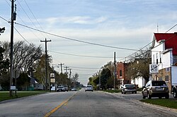
Denmark is a village in Brown County in the U.S. state of Wisconsin. The population was 2,408 at the 2020 census. It is part of the Green Bay Metropolitan Statistical Area. The village is located within the town of New Denmark.

Humboldt is a town in Brown County in the U.S. state of Wisconsin. The population was 1,311 at the 2010 census. The community name was chosen by Henry Fontaine.

Green Bay is a town in Brown County in the U.S. state of Wisconsin. The population was 2,035 at the 2010 census. The town is located several miles northeast of the city of Green Bay. The unincorporated community of Champion is located in the town, and the unincorporated communities of Dyckesville and New Franken are located partially in the town.

City Stadium is an American football stadium in Green Bay, Wisconsin, on the north side of the Green Bay East High School property. It was the home of the Green Bay Packers of the NFL from 1925 through 1956. Renovated and downsized, City Stadium remains the home of East High. Prior to 1925, the Packers played home games at nearby Hagemeister Park and Bellevue Park.

Hagemeister Park was the name of a now defunct park in Green Bay, Wisconsin that was the home of the Green Bay Packers from their founding in 1919 and their first two seasons playing in the National Football League, 1921 and 1922.
Bellevue Park was the name of a stadium used for football games in what is today Green Bay, Wisconsin. The park was just east of the Hagemeister Brewery, which was renamed the "Bellevue Products Co." during Prohibition, and was located just east of Baird Creek along Main Street in the village of Preble, Wisconsin.
WDOR-FM is a radio station licensed to Sturgeon Bay, Wisconsin, United States and serving the Sturgeon Bay, Wisconsin area, as well as Door and Kewaunee Counties along with Green Bay to the South.

Green Bay West High School is a high school in Green Bay, Wisconsin, United States, serving the city's west side. Originally founded in 1890 as the high school for the town of Fort Howard, the school opened as West High School in 1910 and has occupied its current building since 1929.

The Manuka State Wayside Park is a state park of 13.4 acres (5.4 ha) with an arboretum located approximately 19 miles (31 km) west of Naʻalehu, on the Mamalahoa Highway section of the Hawaii Belt Road, on the island of Hawaii, Hawaii, coordinates 19°6′33″N155°49′33″W

Champion is an unincorporated community in the town of Green Bay in Brown County, Wisconsin, United States. It is part of the Green Bay Metropolitan Statistical Area. The town hall for the town of Green Bay is located in Champion and the National Shrine of Our Lady of Good Help is located just east of Champion.

Preble was a town in Brown County, Wisconsin, United States from 1859 to 1964. It ceased to exist as a jurisdiction in 1964, when by referendum it consolidated with the city of Green Bay.
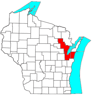
The Green Bay metropolitan statistical area, as defined by the United States Census Bureau, is a metropolitan area in northeastern Wisconsin anchored by the City of Green Bay. It is Wisconsin's fourth largest metropolitan statistical area by population. As of the 2010 Census, the MSA had a combined population of 306,241.

Fontenoy is an unincorporated community in the Town of New Denmark in Brown County, Wisconsin, United States. It is located on County Highway P approximately 2 miles (3.2 km) northeast of the village of Denmark. The communtity was named by Dennis DeWane of Irish heritage in reference to the Irishmen who fought at Fontenoy.
David C. Zuidmulder was an American football player.
Pleasant Corners is a hamlet in the town of Wilson in Niagara County, New York, United States.

Poland is an unincorporated community in the Town of Eaton, Brown County, Wisconsin, United States. It is located at the intersection of County Highway T and Wisconsin Highway 29 several miles east of Green Bay. It is located at latitude 44-26-37N and longitude 87-49-34W. Poland was named for and by the many Polish immigrants that settled in the area during the 1870's. In 1881, community members built SS. Cyril and Methodius Catholic Church in the heart of Poland. The church was destroyed by fire in 1898, and a new church was constructed the following year.
Warfield is a census-designated place (CDP) in Brunswick County, Virginia, United States. The population as of the 2010 Census was 115.
Las Cruces Air Force Station is a closed United States Air Force General Surveillance Radar station. It is located 12.1 miles (19.5 km) west-southwest of Las Cruces, New Mexico. It was closed in 1963.