Little Suamico, Wisconsin

Last updated

Little Suamico, Wisconsin
WIMap-doton-Little Suamico.png
Location of Little Suamico, Wisconsin
Coordinates: 44°42′55″N88°2′45″W / 44.71528°N 88.04583°W / 44.71528; -88.04583
Country Flag of the United States.svg  United States
State Flag of Wisconsin.svg  Wisconsin
County Oconto
Area
  Total37.4 sq mi (96.9 km2)
  Land37.3 sq mi (96.7 km2)
  Water0.1 sq mi (0.2 km2)
Elevation
[1]
633 ft (193 m)
Population
 (2020)
  Total5,536
  Density103.8/sq mi (40.1/km2)
Time zone UTC-6 (Central (CST))
  Summer (DST) UTC-5 (CDT)
Area code 920
FIPS code 55-45275 [2]
GNIS feature ID1583586 [1]
Website http://www.townoflittlesuamico.com

Little Suamico is a town in Oconto County, Wisconsin, United States. The population was 5536 at the 2020 census.

Contents

Communities

History

The earliest records for the town date to 1859, when Ernst Kuntze was the town chair, clerk, and treasurer. [4]

Geography

According to the United States Census Bureau, the town has a total area of 37.4 square miles (96.9 km2), of which, 37.3 square miles (96.7 km2) of it is land and 0.1 square miles (0.2 km2) of it (0.16%) is water.

Demographics

The 2020 US Census lists the town's population at 5536. Up from 4799 in 2010.

As of the census [2] of 2000, there were 3,877 people, 1,358 households, and 1,106 families residing in the town. The population density was 103.8 people per square mile (40.1/km2). There were 1,403 housing units at an average density of 37.6 per square mile (14.5/km2). The racial makeup of the town was 97.86% White, 0.59% African American, 0.54% Native American, 0.26% Asian, 0.03% Pacific Islander, 0.26% from other races, and 0.46% from two or more races. Hispanic or Latino of any race were 0.80% of the population.

There were 1,358 households, out of which 42.3% had children under the age of 18 living with them, 71.1% were married couples living together, 6.1% had a female householder with no husband present, and 18.5% were non-families. 13.6% of all households were made up of individuals, and 4.1% had someone living alone who was 65 years of age or older. The average household size was 2.85 and the average family size was 3.14.

In the town, the population was spread out, with 30.0% under the age of 18, 5.9% from 18 to 24, 35.3% from 25 to 44, 23.3% from 45 to 64, and 5.5% who were 65 years of age or older. The median age was 35 years. For every 100 females, there were 104.7 males. For every 100 females age 18 and over, there were 103.7 males.

The median income for a household in the town was $60,160, and the median income for a family was $64,973. Males had a median income of $39,846 versus $30,213 for females. The per capita income for the town was $22,520. About 2.1% of families and 3.9% of the population were below the poverty line, including 3.4% of those under age 18 and 8.7% of those age 65 or over.

Related Research Articles

<span class="mw-page-title-main">Goodwater, Alabama</span> Town in Alabama, United States

Goodwater is a town in Coosa County, Alabama, United States. At the 2020 census, the population was 1,291. It is part of the Talladega-Sylacauga Micropolitan Statistical Area.

<span class="mw-page-title-main">Mosses, Alabama</span> Town in Alabama, United States

Mosses is a town in Lowndes County, Alabama, United States. At the 2010 census the population was 1,029, down from 1,101 in 2000. It is part of the Montgomery Metropolitan Statistical Area. It incorporated in 1979.

<span class="mw-page-title-main">DeLand Southwest, Florida</span> CDP in Florida, United States

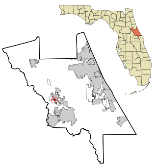
DeLand Southwest is an unincorporated census-designated place located in Volusia County, Florida, United States. The population was 1,056 at the 2020 census.

<span class="mw-page-title-main">South Daytona, Florida</span> City in Florida, United States

South Daytona is a city in Volusia County, Florida, United States. The population was 12,865 at the 2020 census.

<span class="mw-page-title-main">Island Falls, Maine</span> Town in the state of Maine, United States

Island Falls is a town in Aroostook County, Maine, United States. The population was 758 at the 2020 census. The primary village of Island Falls in the town is situated at a falls in the West Branch Mattawamkeag River.

Alton is a town in Penobscot County, Maine, United States. It is part of the Bangor Metropolitan Statistical Area. The population was 829 at the 2020 census. The community is named after an Alton in England.

<span class="mw-page-title-main">Hurlock, Maryland</span> Town in Maryland, United States

Hurlock is a town in Dorchester County, Maryland, United States. The population was 2,092 at the 2010 census.

<span class="mw-page-title-main">Flordell Hills, Missouri</span> City in Missouri, United States

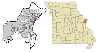
Flordell Hills is a city in St. Louis County, Missouri, United States. The population was 822 at the 2010 census.

Wheatland Township is a township located in the northwest corner of Rice County, Minnesota, United States. The population was 1,358 at the 2000 census.

<span class="mw-page-title-main">Clarkson Valley, Missouri</span> City in Missouri, United States

Clarkson Valley is a city in St. Louis County, Missouri, United States. The population was 2,609 at the 2020 census.

<span class="mw-page-title-main">Elmhurst Township, Lackawanna County, Pennsylvania</span> Place in Pennsylvania, United States

Elmhurst Township is a township in Lackawanna County, Pennsylvania, United States. The population was 836 at the 2020 census.

<span class="mw-page-title-main">Pulaski Township, Lawrence County, Pennsylvania</span> Township in Pennsylvania, United States

Pulaski Township is a township in Lawrence County, Pennsylvania, United States. The population was 3,096 at the 2020 census, a decline from the figure of 3,452 tabulated in 2010.

<span class="mw-page-title-main">Ellsworth, Pennsylvania</span> Borough in Pennsylvania, United States

Ellsworth is a borough in Washington County, Pennsylvania, United States. The population was 947 at the 2020 census. The coal town was founded by James Ellsworth, who bought the land in 1890s, developed the Monongahela Railway, and sold the mines to Bethlehem Steel in the 1920s.

<span class="mw-page-title-main">Richburg, South Carolina</span> Town in South Carolina, United States

Richburg is a town in Chester County, South Carolina, United States. The population was 275 at the 2010 census, down from 332 at the 2000 census.

<span class="mw-page-title-main">Garfield, Washington</span> Town in Washington, United States

Garfield is a city in Whitman County, Washington, United States. The population was 597 at the 2010 census, down from 641 in 2000.

<span class="mw-page-title-main">Suamico, Wisconsin</span> Village in Wisconsin, United States

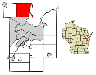
Suamico is a village in Brown County in the U.S. state of Wisconsin. The population was 12,820 at the time of the 2020 census. Suamico is part of the Green Bay Metropolitan Statistical Area, and contains the neighborhood community of Flintville.

<span class="mw-page-title-main">Bridgeport, Wisconsin</span> Town in Wisconsin, United States

Bridgeport is a town in Crawford County, Wisconsin, United States. The population was 946 at the 2000 census. The unincorporated community of Bridgeport is located in the town.

<span class="mw-page-title-main">Kronenwetter, Wisconsin</span> Village in Wisconsin, United States

Kronenwetter is a village in Marathon County, Wisconsin, United States. It is the largest village by land area in the state of Wisconsin, as well as in the entire United States, and the third-largest community by population in Marathon County. It is part of the Wausau, Wisconsin Metropolitan Statistical Area. As of the 2020 census, the population of Kronenwetter was 8,353.

<span class="mw-page-title-main">Tichigan, Wisconsin</span> Census-designated place in Wisconsin, United States

Tichigan is a census-designated place (CDP) in Racine County, Wisconsin, United States. The population was 5,277 at the 2020 census.

<span class="mw-page-title-main">Rock, Rock County, Wisconsin</span> Town in Wisconsin, United States

The Town of Rock is a located in Rock County, Wisconsin, United States. The population was 2,981 at the 2020 census. The unincorporated community of Afton is in the town.

References

  1. 1 2 "US Board on Geographic Names". United States Geological Survey. October 25, 2007. Retrieved January 31, 2008.
  2. 1 2 "U.S. Census website". United States Census Bureau . Retrieved January 31, 2008.
  3. ZIP Code Lookup
  4. Town of Little Suamico.

44°43′03″N88°00′33″W / 44.71750°N 88.00917°W / 44.71750; -88.00917