Pine Grove, Portage County, Wisconsin

Last updated

Pine Grove
Town
USA Wisconsin location map.svg
Red pog.svg
Pine Grove
Location within the state of Wisconsin
Coordinates: 44°17′30″N089°32′20″W / 44.29167°N 89.53889°W / 44.29167; -89.53889
Country Flag of the United States.svg  United States
State Flag of Wisconsin.svg  Wisconsin
County Portage
Area
  Total37.7 sq mi (97.6 km2)
  Land37.6 sq mi (97.5 km2)
  Water0.04 sq mi (0.1 km2)
Elevation
1,079 ft (329 m)
Population
 (2000)
  Total904
  Density24/sq mi (9.3/km2)
Time zone UTC-6 (Central (CST))
  Summer (DST) UTC-5 (CDT)
Area code(s) 715 & 534
FIPS code 5509762825 [1]
GNIS feature ID1583924 [2]

Pine Grove is a town in Portage County, Wisconsin, United States. The population was 904 at the 2000 census. The unincorporated communities of Bancroft and West Bancroft are located within the town.

Contents

Geography

According to the United States Census Bureau, the town has a total area of 37.7 square miles (97.6 km2), of which, 37.7 square miles (97.5 km2) of it is land and 0.04 square miles (0.1 km2) of it (0.11%) is water.

Demographics

As of the census of 2000, there were 904 people, 333 households, and 243 families residing in the town. The population density was 24.0 people per square mile (9.3/km2). There were 371 housing units at an average density of 9.9 per square mile (3.8/km2). The racial makeup of the town was 92.70% White, 0.11% African American, 0.22% Native American, 1.22% Asian, 0.11% Pacific Islander, 4.09% from other races, and 1.55% from two or more races. 10.29% of the population were Hispanic or Latino of any race.

There were 333 households, out of which 37.2% had children under the age of 18 living with them, 59.5% were married couples living together, 8.7% had a female householder with no husband present, and 27.0% were non-families. 23.4% of all households were made up of individuals, and 8.7% had someone living alone who was 65 years of age or older. The average household size was 2.71 and the average family size was 3.21.

In the town, the population was spread out, with 28.7% under the age of 18, 9.0% from 18 to 24, 29.1% from 25 to 44, 22.5% from 45 to 64, and 10.8% who were 65 years of age or older. The median age was 36 years. For every 100 females, there were 107.3 males. For every 100 females age 18 and over, there were 106.7 males.

The median income for a household in the town was $35,294, and the median income for a family was $38,824. Males had a median income of $32,273 versus $17,891 for females. The per capita income for the town was $18,257. 10.0% of the population and 6.6% of families were below the poverty line. Out of the total people living in poverty, 12.1% are under the age of 18 and 9.0% are 65 or older.

Related Research Articles

<span class="mw-page-title-main">Bancroft, Idaho</span> City in Caribou County, Idaho, United States

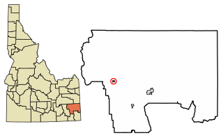
Bancroft is a city in the Gem Valley in Caribou County, Idaho, United States. The population was 377 at the 2010 census.

<span class="mw-page-title-main">Bancroft, Iowa</span> City in Iowa, United States

Bancroft is a city in Kossuth County, Iowa, United States. The population was 699 at the time of the 2020 census.

<span class="mw-page-title-main">Allagash, Maine</span> Town in the state of Maine, United States

Allagash is a town in Aroostook County, Maine, United States. It is on the Allagash River in the North Maine Woods region.

<span class="mw-page-title-main">Bancroft, Maine</span> Unorganized territory in Maine, United States

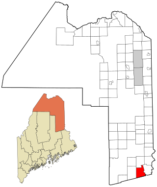
Bancroft is a township in Aroostook County, Maine, United States. The population was 57 at the 2020 census. On July 1, 2015 the town voted to deorganize and become part of the unorganized territory of South Aroostook.

<span class="mw-page-title-main">Hartford, Maine</span> Town in the state of Maine, United States

Hartford is a town in Oxford County, Maine, United States. Hartford is included in the Lewiston-Auburn, Maine metropolitan New England City and Town Area. The population was 1,203 at the 2020 census.

<span class="mw-page-title-main">Bancroft, Michigan</span> Village in Michigan, United States

Bancroft is a village in Shiawassee County in the U.S. state of Michigan. The population was 545 at the 2010 census. The village is located within Shiawassee Township.

<span class="mw-page-title-main">Breezy Point, Minnesota</span> City in Minnesota, United States

Breezy Point is a city in Crow Wing County, Minnesota, United States. It is part of the Brainerd Micropolitan Statistical Area. The population was 2,346 at the 2010 census.

<span class="mw-page-title-main">Pymatuning Township,Pennsylvania</span> Township in Pennsylvania, United States

Pymatuning Township is a township in Mercer County, Pennsylvania, United States. The population was 3,114 at the 2020 census, down from 3,281 in 2010.

<span class="mw-page-title-main">Windham Township, Wyoming County, Pennsylvania</span> Township in Pennsylvania, United States

Windham Township is a township in Wyoming County, Pennsylvania, United States. As of the 2020 census, the township population was 737.

<span class="mw-page-title-main">Bancroft, South Dakota</span> Town in South Dakota, United States

Bancroft is a town in northwest Kingsbury County, South Dakota, United States. The population was 19 at the 2010 census.

<span class="mw-page-title-main">Peterstown, West Virginia</span> Town in West Virginia, United States

Peterstown is a town in Monroe County, West Virginia, United States. The population was 456 at the 2020 census.

<span class="mw-page-title-main">Tunnelton, West Virginia</span> Town in West Virginia, United States

Tunnelton is a town in southwestern Preston County, West Virginia, United States. The population was 307 at the 2020 census. It is part of the Morgantown metropolitan area.

<span class="mw-page-title-main">Bancroft, West Virginia</span> Town in West Virginia, United States

Bancroft is a town in Putnam County, West Virginia, United States, along the Kanawha River. The population was 389 at the 2020 census. It is part of the Huntington–Ashland metropolitan area.

<span class="mw-page-title-main">Woodville, Calumet County, Wisconsin</span> Town in Wisconsin, United States

Woodville is a town in Calumet County in the U.S. state of Wisconsin. The population was 980 at the 2010 census. The unincorporated communities of Dundas and St. John are located in the community.

<span class="mw-page-title-main">Bagley, Oconto County, Wisconsin</span> Town in Wisconsin, United States

Bagley is a town in Oconto County, Wisconsin, United States. The population was 333 at the 2000 United States Census.

<span class="mw-page-title-main">Washington, Sauk County, Wisconsin</span> Town in Wisconsin, United States

Washington is a town in Sauk County, Wisconsin, United States. The population was 904 at the 2000 census. The unincorporated communities of Hill Point and Sandusky are located in the town.

<span class="mw-page-title-main">Sharon, Walworth County, Wisconsin</span> Town in Wisconsin, United States

Sharon is a town in Walworth County, Wisconsin, United States. The population was 861 at the 2020 census. The Village of Sharon is located within the town. The unincorporated community of Allen's Grove is also located partially in the town.

Lowell is a town in Dodge County, Wisconsin, United States. The population was 1,169 at the 2000 census. The Village of Lowell and the unincorporated community of North Lowell are located in the town.

<span class="mw-page-title-main">Hazel Green, Wisconsin</span> Village in Wisconsin, United States

Hazel Green is a village in Grant and Lafayette counties in the U.S. state of Wisconsin. The population was 1,256 at the 2010 census. Of this, 1,243 were in Grant County, and only 13 were in Lafayette County. The village is located mostly within the Town of Hazel Green in Grant County; only a small portion extends into the Town of Benton in Lafayette County.

<span class="mw-page-title-main">Orleans, Indiana</span> Town in Indiana, United States

Orleans is a town in Orleans Township, Orange County, in the U.S. state of Indiana. The population was 2,142 at the 2010 census.

References

  1. "U.S. Census website". United States Census Bureau . Retrieved January 31, 2008.
  2. "US Board on Geographic Names". United States Geological Survey. October 25, 2007. Retrieved January 31, 2008.