Nelsonville, Wisconsin

Last updated

Nelsonville, Wisconsin
Portage County Wisconsin Incorporated and Unincorporated areas Nelsonville Highlighted.svg
Location of Nelsonville in Portage County, Wisconsin.
Coordinates: 44°29′35″N89°18′44″W / 44.49306°N 89.31222°W / 44.49306; -89.31222
Country Flag of the United States.svg  United States
State Flag of Wisconsin.svg  Wisconsin
County Portage
Area
[1]
  Total1.05 sq mi (2.71 km2)
  Land1.03 sq mi (2.67 km2)
  Water0.01 sq mi (0.04 km2)
Elevation
[2]
1,073 ft (327 m)
Population
 (2010) [3]
  Total155
  Estimate 
(2019) [4]
151
  Density146.32/sq mi (56.52/km2)
Time zone UTC-6 (Central (CST))
  Summer (DST) UTC-5 (CDT)
Zip code(s)
54407, 54458
Area code(s) 715 & 534
FIPS code 55-56000 [5]
GNIS feature ID1570168 [2]

Nelsonville is a village in Portage County, Wisconsin, United States. The population was 155 at the 2010 census.

Contents

History

The village was named after Jerome Nelson, an Englishman who started a sawmill along the Tomorrow River in 1855. It was incorporated in 1913, in part in an effort to remove saloons that the town of Amherst refused to outlaw. [6]

Geography

Nelsonville is located at 44°29′35″N89°18′44″W / 44.49306°N 89.31222°W / 44.49306; -89.31222 (44.493067, -89.312358). [7]

According to the United States Census Bureau, the village has a total area of 1.05 square miles (2.72 km2), of which, 1.03 square miles (2.67 km2) of it is land and 0.02 square miles (0.05 km2) is water. [8]

Demographics

Historical population
CensusPop.Note
1920 187
1930 1985.9%
1940 180−9.1%
1950 1884.4%
1960 170−9.6%
1970 152−10.6%
1980 19930.9%
1990 171−14.1%
2000 19111.7%
2010 155−18.8%
2019 (est.)151 [4] −2.6%
U.S. Decennial Census [9]

2010 census

As of the census [3] of 2010, there were 155 people, 61 households, and 39 families living in the village. The population density was 150.5 inhabitants per square mile (58.1/km2). There were 67 housing units at an average density of 65.0 per square mile (25.1/km2). The racial makeup of the village was 96.8% White, 0.6% African American, 0.6% from other races, and 1.9% from two or more races. Hispanic or Latino of any race were 1.3% of the population.

There were 61 households, of which 34.4% had children under the age of 18 living with them, 52.5% were married couples living together, 8.2% had a female householder with no husband present, 3.3% had a male householder with no wife present, and 36.1% were non-families. 26.2% of all households were made up of individuals, and 8.2% had someone living alone who was 65 years of age or older. The average household size was 2.54 and the average family size was 3.03.

The median age in the village was 42.5 years. 25.8% of residents were under the age of 18; 7.2% were between the ages of 18 and 24; 24.5% were from 25 to 44; 27.8% were from 45 to 64; and 14.8% were 65 years of age or older. The gender makeup of the village was 50.3% male and 49.7% female.

2000 census

As of the census [5] of 2000, there were 191 people, 72 households, and 52 families living in the village. The population density was 190.7 people per square mile (73.7/km2). There were 74 housing units at an average density of 73.9 per square mile (28.6/km2). The racial makeup of the village was 97.38% White, 1.05% Native American, and 1.57% from two or more races.

There were 72 households, out of which 30.6% had children under the age of 18 living with them, 66.7% were married couples living together, 5.6% had a female householder with no husband present, and 26.4% were non-families. 23.6% of all households were made up of individuals, and 6.9% had someone living alone who was 65 years of age or older. The average household size was 2.65 and the average family size was 3.09.

In the village, the population was spread out, with 28.8% under the age of 18, 5.8% from 18 to 24, 33.5% from 25 to 44, 20.9% from 45 to 64, and 11.0% who were 65 years of age or older. The median age was 34 years. For every 100 females, there were 89.1 males. For every 100 females age 18 and over, there were 88.9 males.

The median income for a household in the village was $41,875, and the median income for a family was $56,250. Males had a median income of $32,500 versus $23,438 for females. The per capita income for the village was $19,708. None of the families and 2.4% of the population were living below the poverty line, including no under eighteens and 13.0% of those over 64.

Related Research Articles

<span class="mw-page-title-main">New Stuyahok, Alaska</span> City in Alaska, United States

New Stuyahok is a city in Dillingham Census Area, Alaska, United States. At the 2010 census the population was 510, up from 471 in 2000.

<span class="mw-page-title-main">Brevig Mission, Alaska</span> City in Alaska, United States

Brevig Mission is a city in Nome Census Area, Alaska. The population was 388 at the 2010 census, up from 276 in 2000. It is named for the Norwegian Lutheran pastor Tollef L. Brevig, who served at the mission that would later bear his name. First settled in 1900, the mission became known as Teller Mission before receiving its current name. The mostly Inupiat Eskimo population continues to practice subsistence. Brevig Mission is a dry village, which means the sale or possession of alcohol is illegal.

<span class="mw-page-title-main">Gordonville, Missouri</span> Village in Missouri, United States

Gordonville is a village in Cape Giradeau County, Missouri, United States. The population was 625 at the 2020 census. It is part of the Cape Girardeau–Jackson, MO-IL Metropolitan Statistical Area.

<span class="mw-page-title-main">Cedar Creek, Nebraska</span> Village in Nebraska, United States

Cedar Creek is a village in Cass County, Nebraska, United States. The population was 465 at the 2020 census.

<span class="mw-page-title-main">Nelsonville, New York</span> Village in New York, United States

Nelsonville is a village located in the town of Philipstown in Putnam County, New York, United States. The population was 628 at the time of the 2010 census.

<span class="mw-page-title-main">York, North Dakota</span> City in North Dakota, United States

York is a small rural village in Benson County, North Dakota, United States. The population was 17 at the 2020 census. There is a gasoline station there, and a granary, and farm equipment repair services.

<span class="mw-page-title-main">Jacksonville, Ohio</span> Village in Ohio, United States

Jacksonville is a village in Athens County, Ohio, United States. The population was 400 at the 2020 census.

<span class="mw-page-title-main">Gettysburg, Ohio</span> Village in Ohio, United States

Gettysburg is a village in Darke County, Ohio, United States. The population was 463 at the 2020 census.

<span class="mw-page-title-main">Murray City, Ohio</span> Village in Ohio, United States

Murray City is a village in Hocking County, Ohio, United States. The population was 341 at the 2020 census.

<span class="mw-page-title-main">Chickasaw, Ohio</span> Village in Ohio, United States

Chickasaw is a village in Mercer County, Ohio, United States. The population was 358 at the 2020 census.

<span class="mw-page-title-main">Clearview, West Virginia</span> Village in West Virginia, United States

Clearview is a village in Ohio County, West Virginia, United States. It is part of the Wheeling, West Virginia Metropolitan Statistical Area. The population was 565 at the 2010 census.

<span class="mw-page-title-main">Marathon City, Wisconsin</span> Village in Wisconsin, United States

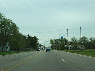
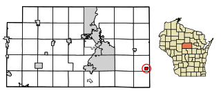
Marathon City is a village in Marathon County, Wisconsin, United States. It is part of the Wausau, Wisconsin Metropolitan Statistical Area. The population was 1,524 at the 2010 census. The village was incorporated from a part of the original area of the town of Marathon. The village dates back to 1856. The name of the village commemorates the Battle of Marathon.

<span class="mw-page-title-main">Rosholt, Wisconsin</span> Village in Wisconsin, United States

Rosholt is a village in Portage County, Wisconsin, United States. The population was 478 at the 2020 census.

<span class="mw-page-title-main">Whiting, Wisconsin</span> Village in Wisconsin, United States

Whiting is a village in Portage County, Wisconsin, United States and is a suburb of Stevens Point. It is included in the Stevens Point Micropolitan Statistical Area. The population was 1,601 at the 2020 census.

<span class="mw-page-title-main">Big Falls, Waupaca County, Wisconsin</span> Village in Wisconsin, United States

Big Falls is a village in Waupaca County, Wisconsin, United States. The population was 61 at the 2010 census.

<span class="mw-page-title-main">Buchtel, Ohio</span> Village in Ohio, United States

Buchtel is a village in Athens and Hocking counties in the U.S. state of Ohio, just northeast of Nelsonville. Located in the Hocking Valley, it was a center of coal mining in the late 19th and early 20th centuries. The population was 518 at the 2020 census. A former name for the village is Bessemer.

<span class="mw-page-title-main">Arena, Wisconsin</span> Village in Wisconsin, United States

Arena is a village in Iowa County, Wisconsin, United States. The population was 834 at the 2010 census. The village is located within the Town of Arena. It is part of the Madison Metropolitan Statistical Area.

<span class="mw-page-title-main">Elderon, Wisconsin</span> Village in Wisconsin, United States

Elderon is a village in Marathon County, Wisconsin, United States. It is part of the Wausau, Wisconsin Metropolitan Statistical Area. The population was 179 at the 2010 census.

Baldwin is a town in St. Croix County, Wisconsin, United States. The population was 903 at the 2000 census. The Village of Baldwin is located partially within the town. The unincorporated community of Dahl is also located in the town.

<span class="mw-page-title-main">Scandinavia, Wisconsin</span> Village in Wisconsin, United States

Scandinavia is a village in the Town of Scandinavia in Waupaca County, Wisconsin, United States. The population was 328 at the 2010 census.

References

  1. "2019 U.S. Gazetteer Files". United States Census Bureau. Retrieved August 7, 2020.
  2. 1 2 "US Board on Geographic Names". United States Geological Survey. October 25, 2007. Retrieved January 31, 2008.
  3. 1 2 "U.S. Census website". United States Census Bureau . Retrieved November 18, 2012.
  4. 1 2 "Population and Housing Unit Estimates". United States Census Bureau. May 24, 2020. Retrieved May 27, 2020.
  5. 1 2 "U.S. Census website". United States Census Bureau . Retrieved January 31, 2008.
  6. History of Nelsonville. Portage County Historical Society.
  7. "US Gazetteer files: 2010, 2000, and 1990". United States Census Bureau. February 12, 2011. Retrieved April 23, 2011.
  8. "US Gazetteer files 2010". United States Census Bureau. Archived from the original on January 25, 2012. Retrieved November 18, 2012.
  9. "Census of Population and Housing". Census.gov. Retrieved June 4, 2015.