New Hope, Wisconsin

Last updated

New Hope, Wisconsin
WIMap-doton-New Hope.png
Location of New Hope, Wisconsin
Coordinates: 44°32′52″N89°17′03″W / 44.54778°N 89.28417°W / 44.54778; -89.28417
Country Flag of the United States.svg  United States
State Flag of Wisconsin.svg  Wisconsin
County Portage
Area
  Total36.4 sq mi (94.2 km2)
  Land35.9 sq mi (92.9 km2)
  Water0.5 sq mi (1.3 km2)
Elevation
[1]
1,135 ft (346 m)
Population
 (2000)
  Total736
  Density20.5/sq mi (7.9/km2)
Time zone UTC-6 (Central (CST))
  Summer (DST) UTC-5 (CDT)
Area code(s) 715 & 534
FIPS code 55-56850 [2]
GNIS feature ID1583811 [1]
Website https://www.townofnewhope.org

New Hope is a town in Portage County, Wisconsin, United States. The population was 736 at the 2000 census. The unincorporated communities of New Hope, Garfield, and Peru are located in the town.

Contents

Geography

According to the United States Census Bureau, the town has a total area of 36.4 square miles (94.2 km2), of which, 35.9 square miles (92.9 km2) of it is land and 0.5 square miles (1.3 km2) of it (1.38%) is water.

Demographics

As of the census [2] of 2000, there were 736 people, 278 households, and 219 families residing in the town. The population density was 20.5 people per square mile (7.9/km2). There were 365 housing units at an average density of 10.2 per square mile (3.9/km2). The racial makeup of the town was 99.05% White, 0.27% Native American, 0.14% from other races, and 0.54% from two or more races. Hispanic or Latino of any race were 0.82% of the population.

There were 278 households, out of which 34.2% had children under the age of 18 living with them, 68.0% were married couples living together, 7.2% had a female householder with no husband present, and 21.2% were non-families. 16.5% of all households were made up of individuals, and 7.6% had someone living alone who was 65 years of age or older. The average household size was 2.65 and the average family size was 3.00.

In the town, the population was spread out, with 25.7% under the age of 18, 5.4% from 18 to 24, 27.7% from 25 to 44, 26.4% from 45 to 64, and 14.8% who were 65 years of age or older. The median age was 41 years. For every 100 females, there were 107.3 males. For every 100 females age 18 and over, there were 100.4 males.

The median income for a household in the town was $46,538, and the median income for a family was $48,125. Males had a median income of $35,208 versus $27,375 for females. The per capita income for the town was $21,334. About 3.9% of families and 6.3% of the population were below the poverty line, including 5.2% of those under age 18 and none of those age 65 or over.

Notable people

Related Research Articles

<span class="mw-page-title-main">Margaret, Alabama</span> City in Alabama, United States

Margaret is a city in St. Clair County, Alabama, United States. At the 2020 census, the population was 5,106. As of the 2010 census, the population is 4,428, an increase of 278.8%. Margaret incorporated in 1960 and became a city in October 2011.

<span class="mw-page-title-main">St. Paul, Indiana</span> Town in Indiana, United States

St. Paul or Saint Paul is a small town on the border of Decatur and Shelby counties in the U.S. state of Indiana. The population was 1,031 at the 2010 census.

<span class="mw-page-title-main">Mount Summit, Indiana</span> Town in Indiana, United States

Mount Summit is a town in Prairie Township, Henry County, Indiana, United States. The population was 352 at the 2010 census.

<span class="mw-page-title-main">White Cloud, Michigan</span> City in Michigan, United States

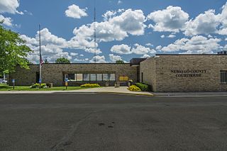
White Cloud is a city in the U.S. state of Michigan, a small town on the bank of the White River. As of the 2020 census, the city population was 1,479. It is the county seat of Newaygo County. Being designated a trail town, the outdoors are a big part of life in White Cloud, with the 4,600 mile North Country Trail stretching nearby, the Mill Pond Park with a beach and playground, and the White Cloud County Park and Campground, being major draws to the area. White Cloud was recognized by the North Country Trail Association as a "Trail Town".

<span class="mw-page-title-main">Linneus, Missouri</span> City in Missouri, United States

Linneus is a small city in Linn County, Missouri, United States. The population was 281 at the 2020 census. It is the county seat of Linn County.

<span class="mw-page-title-main">Forestport, New York</span> Town in New York, United States

Forestport is a town in Oneida County, New York, United States. The population was 1,477 at the 2020 census.

<span class="mw-page-title-main">West Liberty, Ohio</span> Village in Ohio, United States

West Liberty is a village in Logan County, Ohio, United States. The population was 1,770 at the 2020 census.

<span class="mw-page-title-main">Mineral City, Ohio</span> Village in Ohio, United States

Mineral City is a village in Tuscarawas County, Ohio, United States. The population was 652 at the 2020 census.

<span class="mw-page-title-main">Wilkesville, Ohio</span> Village in Ohio, United States

Wilkesville is a village in Vinton County, Ohio, United States. The population was 116 at the 2020 census.

<span class="mw-page-title-main">Boggs Township, Clearfield County, Pennsylvania</span> Township in Pennsylvania, United States

Boggs Township is a township in Clearfield County, Pennsylvania, United States. The population was 1,666 at the 2020 census.

<span class="mw-page-title-main">York Haven, Pennsylvania</span> Borough in Pennsylvania, United States

York Haven is a borough in York County, Pennsylvania, United States. The population was 691 at the 2020 census. It is part of the York–Hanover metropolitan area. The borough is the home of the Brunner Island coal-fired electrical generation plant, located on the Susquehanna River on Wago Road and operated by PPL Corporation.

<span class="mw-page-title-main">West Haven, Vermont</span> Town in Vermont, United States

West Haven is a town in Rutland County, Vermont, United States. The population was 239 at the 2020 census.

<span class="mw-page-title-main">Spangle, Washington</span> City in Washington, United States

Spangle is a city in Spokane County, Washington, United States. The population was 278 at the 2010 census. The name comes from William Spangle, an early pioneer.

<span class="mw-page-title-main">Winfield, West Virginia</span> City in West Virginia, United States

Winfield is a city in and the county seat of Putnam County, West Virginia, United States, located along the Kanawha River. The population was 2,397 at the 2020 census. It is part of the Huntington–Ashland metropolitan area.

<span class="mw-page-title-main">Huttonsville, West Virginia</span> Town in West Virginia, United States

Huttonsville is a town in Randolph County, West Virginia, United States, along the Tygart Valley River. The population was 163 at the 2020 census.

<span class="mw-page-title-main">Newport, Wisconsin</span> Town in Wisconsin, United States

The Town of Newport is located in Columbia County, Wisconsin, United States. The population was 681 at the 2000 census. The ghost town of Moe Settlement was located in the town.

<span class="mw-page-title-main">Paris, Grant County, Wisconsin</span> Town in Wisconsin, United States

Paris is a town in Grant County, Wisconsin, United States. The population was 754 at the 2000 census.

<span class="mw-page-title-main">Eau Pleine, Marathon County, Wisconsin</span> Town in Wisconsin, United States

Eau Pleine is a town in Marathon County, Wisconsin, United States. It is part of the Wausau, WI Metropolitan Statistical Area. The population was 773 at the 2010 census. The unincorporated communities of Little Rose, March Rapids, and Weber are located in the town. The ghost town of Staadts was also located in the town.

Highland is a town in Iowa County, Wisconsin, United States. The population was 797 at the 2000 census. The village of Highland is located within the town.

Fremont is a town in Waupaca County, Wisconsin, United States. The population was 632 at the 2000 census. The village of Fremont is located within the town. The unincorporated community of Red Banks is located in the town.

References

  1. 1 2 "US Board on Geographic Names". United States Geological Survey. October 25, 2007. Retrieved January 31, 2008.
  2. 1 2 "U.S. Census website". United States Census Bureau . Retrieved January 31, 2008.