Goochland County is a county located in the Piedmont of the Commonwealth of Virginia. Its southern border is formed by the James River. As of the 2020 census, the population was 24,727. Its county seat is Goochland.

Chesterfield County is located just south of Richmond in the Commonwealth of Virginia. The county's borders are primarily defined by the James River to the north and the Appomattox River to the south. Its county seat is Chesterfield Court House.

Charles City County is a county located in the U.S. commonwealth of Virginia. The county is situated southeast of Richmond and west of Jamestown. It is bounded on the south by the James River and on the east by the Chickahominy River.

Mineral is a town in Louisa County, Virginia, United States. The population was 467 at the 2010 census.

Pocahontas is a town in Tazewell County, Virginia, United States. It was named for Chief Powhatan's daughter, Pocahontas, who lived in the 17th-century Jamestown Settlement. The town was founded as a company mining town by the Southwest Virginia Improvement Company in 1881. It was the first company mining town in Virginia. The post office opened on June 30, 1882.

The Appomattox Court House National Historical Park is a preserved 19th-century village in Appomattox County, Virginia. The village is the site of the Battle of Appomattox Court House, and contains the McLean House, where the surrender of the Army of Northern Virginia under Robert E. Lee to Union commander Ulysses S. Grant took place on April 9, 1865, an event widely symbolic of the end of the American Civil War. The village itself began as the community of Clover Hill, which was made the county seat of Appomattox County in the 1840s. The village of Appomattox Court House entered a stage of decline after it was bypassed by a railroad in 1854. In 1930, the United States War Department was authorized to erect a monument at the site, and in 1933 the War Department's holdings there was transferred to the National Park Service. The site was greatly enlarged in 1935, and a restoration of the McLean House was planned but was delayed by World War II. In 1949, the restored McLean House was reopened to the public. Several restored buildings, as well as a number of original 19th-century structures are situated at the site.
Midlothian is an unincorporated area and Census-designated place in Chesterfield County, Virginia, U.S. Settled as a coal town, Midlothian village experienced suburbanization effects and is now part of the western suburbs of Richmond, Virginia south of the James River in the Greater Richmond Region. Because of its unincorporated status, Midlothian has no formal government, and the name is used to represent the original small Village of Midlothian and a vast expanse of Chesterfield County in the northwest portion of Southside Richmond served by the Midlothian post office.

Arvonia is an unincorporated community in Buckingham County, Virginia founded mainly by Welsh immigrants during the mid-19th century. The town derives its name from the county of Caernarfon, Wales. The county is known popularly simply as Arfon. "Arvonia" is the Latin form of the name. Its major industry has been slate mining. The slate is known primarily for its color and durability, and is featured on many prominent American buildings, such as the Smithsonian Castle, the University of Virginia, Berkeley, Virginia's Executive Mansion, and Colonial Revival homes across the country. Buckingham slate quarried in Arvonia earned gold medals at the Philadelphia Exposition in 1876, the 1893 World's Columbia Exposition, and the Louisiana Purchase Exposition at the 1904 Saint Louis World's Fair. Arvonia-Buckingham Slate Corporation was incorporated in 1913 and its operations continue in the present day.

Varina is a former unincorporated community and current magisterial district in the easternmost portion of Henrico County, Virginia, United States.

The Southside of Richmond is an area of the Metropolitan Statistical Area surrounding Richmond, Virginia. It generally includes all portions of the City of Richmond that lie south of the James River, and includes all of the former city of Manchester. Depending on context, the term "Southside of Richmond" can include some northern areas of adjacent Chesterfield County, Virginia in the Richmond-Petersburg region. With minor exceptions near Bon Air, VA, the Chippenham Parkway forms the border between Chesterfield County and the City of Richmond portions of Southside, with some news agencies using the term "South Richmond" to refer to the locations in Southside located in the city proper.
Chesterfield County Public Schools is the public school system of Chesterfield County, Virginia, United States. As of 2020, there are about 64,000 students enrolled in 66 schools. There are 40 elementary schools, 12 middle schools, and 11 high schools. Additionally, high school students can enroll in 13 specialty centers, two technical centers, and two Governor's Schools.
Clover is an unincorporated community and census-designated place (CDP) in rural Halifax County, Virginia, United States. The population as of the 2010 census was 438. Clover was an incorporated town from 1895 until 1998, when it reverted to unincorporated status. Clover was the site of a Rosenwald school, built around 1921 or 1922, with a three-teacher facility on a 2-acre campus.
Clover Hill or Clover Hill Historic District may refer to:

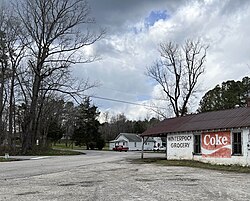
Eppington is a historic plantation house located near Winterpock, Chesterfield County, Virginia. It was built about 1768, and consists of a three-bay, 2+1⁄2-story, central block with hipped roof, dormers, modillion cornice, and flanking one-story wings in the Georgian style. It has a later two-story rear ell. It features two tall exterior end chimneys which rise from the roof of the wings. It was listed on the National Register of Historic Places in 1969.

Cloverhill is an unincorporated community located at the intersection of the boundaries of East Amwell and Raritan townships in Hunterdon County and Hillsborough Township in Somerset County, in the U.S. state of New Jersey. The Clover Hill Historic District was listed on the state and national registers of historic places in 1980.

In 1886, Randolph Harrison, of the Virginia department of Agriculture, cited Cumberland Mining Company, stating that the United States had purchased stock in the Brighthope Railway. He continued by citing their assertion that extending the railway into Cumberland would increase the value of farms there because they could sell consumer agricultural products such as fruit, dairy and vegetables to all markets of Virginia. The Brighthope Railway was founded in 1877 by the creditors of the Clover Hill Railroad who bought that railroad when the Clover Hill Railroad went bankrupt. The Brighthope Railway continued in the role of the Clover Hill Railroad, hauling coal from the Clover Hill Pits at Winterpock, Virginia. In addition to coal, the Bright Hope Railway transported timber and agricultural products and had passenger service. The Bright Hope Railway was narrowed from standard gauge to narrow gauge and rerouted in 1881. In 1886, much of the southern rails were changed to standard gauge. The Brighthope Railway was not changed back.

The Clover Hill Railroad was a railroad company that operated for 36 years in central Virginia near Richmond. The railroad was created to carry coal most efficiently from the Clover Hill Pits in Winterpock, Virginia, to further transportation points in Chester, Virginia, where it could be sold for a better price than on the Appomattox River in the Piedmont region. This made the railroad important to the Confederacy in the Civil War to ensure a supply of coal for munitions and iron working. The mines were dangerous for the miners, and many accidents occurred. The railroad had to be sold when coal mining declined so that new owners could find other uses for the railroad.

In 1886, Randolph Harrison, of the Virginia department of Agriculture, cited Cumberland Mining Company, stating that businessmen would soon open a hotel at Lithia Springs, Farmville, VA for people seeking the healing waters. The Brighthope railway would be extended to bring them there. But instead, the Farmville and Powhatan Railroad Company built the narrow gauge rails through Cumberland County and the Farmville and Powhatan Railroad Company bought the Brighthope Railway, so the Farmville and Powhatan Railroad made the connection. In 1890, Beach Station was built with a railroad depot, some railroad shanties, a general store and an owner's house, the George Perdue House as a stop on the line.

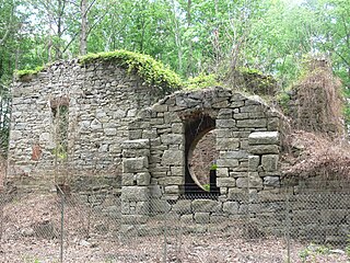
The Clover Hill Pits are a number of coal shafts and mines that operated in the Southside area of Richmond, Virginia, from 1837 until around 1883.

Salisbury was a house and plantation in northwestern Chesterfield County, Virginia in the Southside area of Metro Richmond, Virginia. It was most likely built in the early 1760s by Abraham Salle (c.1732-c.1800), a descendant of Huguenot refugees fleeing persecution in France. Salle's grandfather, also named Abraham (1670–1719), was the immigrant ancestor for most of the Huguenot Salles living in Colonial Virginia. Abraham Salle had "assembled the original 1,500 acre tract between 1760 to 1763" from various parcels of land primarily owned by his uncles William and Robert Wooldridge. The Wooldridge's had inherited the land from their father, John "Blacksmith" Wooldridge (c.1678-1757), himself the immigrant ancestor of all Wooldridges living in the American South.