1883 Atlantic hurricane season

Last updated
1883 Atlantic hurricane season
1883 Atlantic hurricane season summary map.png
Season summary map
Seasonal boundaries
First system formedAugust 18, 1883
Last system dissipatedOctober 24, 1883
Strongest storm
NameTwo
  Maximum winds125 mph (205 km/h)
(1-minute sustained)
  Lowest pressure948 mbar (hPa; 27.99 inHg)
Seasonal statistics
Total storms4
Hurricanes3
Major hurricanes
(Cat. 3+)
2
Total fatalities236
Total damageUnknown
Atlantic hurricane seasons
1881, 1882, 1883, 1884, 1885

The 1883 Atlantic hurricane season ran through the summer and the first half of fall in 1883. This is the period of each year when most tropical cyclones form in the Atlantic basin. In the 1883 Atlantic season there was one tropical storm, one Category 1 hurricane, and two major hurricanes (Category 3+). However, in the absence of modern satellite monitoring and remote-sensing technologies, only storms that affected populated land areas or encountered ships at sea were recorded, so the actual total could be higher. An undercount bias of zero to six tropical cyclones per year between 1851 and 1885 and zero to four per year between 1886 and 1910 has been estimated. [1]

Contents

Season summary

The Atlantic hurricane database (HURDAT) [2] recognizes four tropical cyclones for the 1883 season. In 1883 there was one tropical storm, one Category 1 hurricane and two major hurricanes in the Atlantic basin. Due to the inactivity of the season, there were no storms in June, July or November. Both Hurricane One and Hurricane Two were active in the Western Atlantic throughout the second half of August. Although Hurricane One was the only storm of the year not to make a landfall, it did cause 80 deaths among seafarers off Newfoundland. Hurricane Three was a major hurricane that was first seen in the Lesser Antilles and travelled north to eventually dissipate over Virginia. It caused 106 deaths in the Bahamas and North Carolina. The last known cyclone was a tropical storm active in October between the Bahamas and the coast of North Carolina.

Timeline

Saffir–Simpson Hurricane Scale1883 Atlantic hurricane season

Systems

Hurricane One

Category 1 hurricane (SSHWS)
1883 Atlantic hurricane 1 track.png  
DurationAugust 18 – August 27
Peak intensity90 mph (150 km/h) (1-min);
975  mbar  (hPa)

The Atlantic hurricane database (HURDAT) begins the track for this cyclone about 850 mi (1,370 km) east-northeast of the Leeward Islands on August 18, [3] one day before being encountered by the bark B. F. Watson. [4] :34 Initially a tropical storm, the system moved on a west-northwestward path that gradually became more northwestward. Late on August 21, the storm turned north-northwestward and intensified into a hurricane early the next day while situated southwest of Bermuda. The cyclone then turned northeastward on August 23 and continued to slowly strengthen. [3] Late on August 26, the ship Finchley observed a barometric pressure of 975 mbar (28.8 inHg), the lowest associated with the storm. [4] :35 Consequently, the Atlantic hurricane reanalysis project estimated in 2003 that the hurricane peaked with maximum sustained winds of 90 mph (150 km/h). [5] However, the hurricane lost tropical characteristics and on August 27, it transitioned into an extratropical cyclone about 775 mi (1,245 km) northeast of Newfoundland. The extratropical cyclone dissipated northwest of the British Isles on August 28. [3] [2]

The hurricane wreaked havoc on ships over the Grand Banks of Newfoundland. According to a September 1 report in The New York Times , 100  dories were lost and a total of 80 deaths occurred, though The Times of London noted on September 6 that 30 vessels remained missing. The latter also declared that "immense damage has been done to shipping". [4] :35

Hurricane Two

Category 3 hurricane (SSHWS)
1883 Atlantic hurricane 2 track.png  
DurationAugust 24 – August 30
Peak intensity125 mph (205 km/h) (1-min);
≤948  mbar  (hPa)

On August 24, the bark N. Boynton encountered a hurricane to the northeast of the Leeward Islands, [4] :36 with the official track initiated about 400 mi (640 km) from Barbuda. This storm moved on a similar path to the previous, trekking west-northwestward and then northwestward, followed by a turn to the north on August 27. Intensification occurred during this time, and early the next day, the cyclone reached major hurricane status, becoming a Category 3 hurricane on the present-day Saffir–Simpson scale while passing west of Bermuda. [3] A brig known as Daphne observed a barometric pressure of 948 mbar (28.0 inHg) on August 29. [4] :37 Based on this, the Atlantic hurricane reanalysis project estimated that this storm attained peak winds of 125 mph (205 km/h). [5] The storm then turned northeastward and gradually weakened. Late on August 30, the system passed near Newfoundland as a Category 1 hurricane and soon transitioned into an extratropical cyclone. The extratropical storm persisted until September 2, when it struck the British Isles at hurricane-equivalent intensity and lost its identity over East Anglia. [3]

The hurricane generated sustained winds up to 40 mph (64 km/h) on Bermuda. [6] In Nova Scotia, winds blew "with great violence" in Halifax, according to The New York Times. Two yachts and a number of other vessels became stranded or capsized. [4] :38 In early September, the extratropical remnants reached the British Isles as a powerful storm. [3] Abnormally high tides were reported in Ireland, flooding low-lying homes in the town of Wexford. At least one person died after the steamer Iris capsized at Inishtrahull island. [7] :16 Crops, especially grain, suffered extensive damage in southern Ireland, leading to concerns about the renewal of rent agitation. [8] In Great Britain, barometers fell to as low as 963 mbar (28.4 inHg) at Pembroke, Wales. [4] :40 Several vessels capsized, especially along the south coast of England, causing a numerous loss of life. In one instance, 12 out of 14 occupants of the G. J. Jones (or G I. Jones) drowned after the bark sank in Mount's Bay near Penzance. [9] Waves swept away nearly 0.5 mi (0.80 km) of the Portland Branch Railway. [10] However, the storm also caused some waterways to fall to abnormally low tides, interfering with boat traffic on the River Thames. [7] :17 The Royal Meteorological Society noted that the extratropical cyclone also impacted France, Germany, and Norway. [7] :11 In France, one ship at Bayonne and several others near Bordeaux capsized, "with loss of hands" in the vicinity of the latter according to The Times. [11]

Hurricane Three

Category 3 hurricane (SSHWS)
1883 Atlantic hurricane 3 track.png  
DurationSeptember 4 – September 13
Peak intensity125 mph (205 km/h) (1-min);
955  mbar  (hPa)

The Bahamas-North Carolina Hurricane of 1883

A major hurricane moved through the Lesser Antilles on September 4. It crossed Hispaniola, weakening to a minimal hurricane. It restrengthened as it passed the Bahamas, and struck North Carolina as a Category 2 hurricane on the 11th. It dissipated over Virginia on September 13. [2] Across North Carolina trees were uprooted and fences, light buildings, telegraph and telephone lines blown down . Several vessels were wrecked off the North Carolina coast and flooding occurred along the Cape Fear River. [12] In Virginia the rains from this storm helped end a summer-long drought but any benefit was minimal, as the peanut crop had already failed from the lack of rain. At Nottoway, Virginia, heavy rain from the cyclone may have led to a train with 10 freight cars derailing. [13] Overall the hurricane caused 106 deaths in the Bahamas and North Carolina. [14]

Tropical Storm Four

Tropical storm (SSHWS)
1883 Atlantic hurricane 4 track.png  
DurationOctober 22 – October 24
Peak intensity60 mph (95 km/h) (1-min);
983  mbar  (hPa)

A tropical storm formed on October 22 over the Bahamas. It moved to the north, then turned to the northeast while off the North Carolina coastline. The storm peaked at 60 mph (97 km/h) on October 24 before becoming extratropical the same night. As an extratropical cyclone it strengthened to an 80 mph (130 km/h) storm before dissipating. [2]

See also

Related Research Articles

<span class="mw-page-title-main">1929 Atlantic hurricane season</span> Hurricane season in the Atlantic Ocean

The 1929 Atlantic hurricane season was among the least active Atlantic hurricane seasons on record, with only five tropical cyclones forming. Three of them intensified into a hurricane, with one strengthening further into a major hurricane. The first tropical cyclone of the season developed in the Gulf of Mexico on June 27. Becoming a hurricane on June 28, the storm struck Texas, bringing strong winds to a large area. Three fatalities were reported, while damage was conservatively estimated at $675,000 (1929 USD).

<span class="mw-page-title-main">1927 Atlantic hurricane season</span> Hurricane season in the Atlantic Ocean

The 1927 Atlantic hurricane season was a relatively inactive season, with eight tropical storms, four of which became hurricanes. One of these became a major hurricane – Category 3 or higher on the modern day Saffir–Simpson scale. The first system, a tropical depression, developed on August 13, while the final cyclone, a tropical storm, merged with a cold front on November 21. No hurricane made landfall in the United States, in contrast to the four that struck the U.S. in the previous season.

<span class="mw-page-title-main">1919 Atlantic hurricane season</span> Hurricane season in the Atlantic Ocean

The 1919 Atlantic hurricane season was among the least active hurricane seasons in the Atlantic on record, featuring only five tropical storms. Of those five tropical cyclones, two of them intensified into a hurricane, with one strengthening into a major hurricane Two tropical depressions developed in the month of June, both of which caused negligible damage. A tropical storm in July brought minor damage to Pensacola, Florida, but devastated a fleet of ships. Another two tropical depressions formed in August, the first of which brought rainfall to the Lesser Antilles.

<span class="mw-page-title-main">1915 Atlantic hurricane season</span> Hurricane season in the Atlantic Ocean

The 1915 Atlantic hurricane season was an active Atlantic hurricane season in which six tropical storms developed. The first storm, which remained a tropical depression, appeared on April 29 near the Bahamas, while the final system, also a tropical depression, was absorbed by an extratropical cyclone well south of Newfoundland on October 22. Of the six tropical storms, five intensified into a hurricane, of which three further strengthened into a major hurricane. Four of the hurricanes made landfall in the United States. The early 20th century lacked modern forecasting and documentation, and thus, the hurricane database from these years may be incomplete.

<span class="mw-page-title-main">1913 Atlantic hurricane season</span> Hurricane season in the Atlantic Ocean

The 1913 Atlantic hurricane season was the third consecutive year with a tropical cyclone developing before June. The first system, a tropical depression, developed on May 5 while the last transitioned into an extratropical cyclone on October 30. Of note, the seventh and eighth cyclones existed simultaneously from August 30 to September 4.

<span class="mw-page-title-main">1904 Atlantic hurricane season</span> Hurricane season in the Atlantic Ocean

The 1904 Atlantic hurricane season featured no tropical cyclones during the months of July and August. The season's first cyclone was initially observed in the southwestern Caribbean on June 10. After this storm dissipated on June 14, the next was not detected until September 8. The sixth and final system transitioned into an extratropical cyclone offshore South Carolina on November 4. Two of the six tropical cyclones existed simultaneously.

<span class="mw-page-title-main">1903 Atlantic hurricane season</span> Hurricane season in the Atlantic Ocean

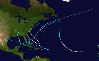
The 1903 Atlantic hurricane season featured seven hurricanes, the most in an Atlantic hurricane season since 1893. The first tropical cyclone was initially observed in the western Atlantic Ocean near Puerto Rico on July 21. The tenth and final system transitioned into an extratropical cyclone well northwest of the Azores on November 25. These dates fall within the period with the most tropical cyclone activity in the Atlantic. Six of the ten tropical cyclones existed simultaneously.

<span class="mw-page-title-main">1899 Atlantic hurricane season</span> Hurricane season in the Atlantic Ocean

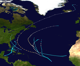
The 1899 Atlantic hurricane season featured the longest-lasting tropical cyclone in the Atlantic basin on record. There were nine tropical storms, of which five became hurricanes. Two of those strengthened into major hurricanes, which are Category 3 or higher on the modern day Saffir–Simpson hurricane wind scale. The first system was initially observed in the northeastern Gulf of Mexico on June 26. The tenth and final system dissipated near Bermuda on November 10. These dates fall within the period with the most tropical cyclone activity in the Atlantic. In post-season analysis, two tropical cyclones that existed in October were added to HURDAT – the official Atlantic hurricane database. At one point during the season, September 3 through the following day, a set of three tropical cyclones existed simultaneously.

<span class="mw-page-title-main">1898 Atlantic hurricane season</span> Hurricane season in the Atlantic Ocean

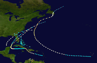
The 1898 Atlantic hurricane season marked the beginning of the Weather Bureau operating a network of observation posts across the Caribbean Sea to track tropical cyclones, established primarily due to the onset of the Spanish–American War. A total of eleven tropical storms formed, five of which intensified into a hurricane, according to HURDAT, the National Hurricane Center's official database. Further, one cyclone strengthened into a major hurricane. However, in the absence of modern satellite and other remote-sensing technologies, only storms that affected populated land areas or encountered ships at sea were recorded, so the actual total could be higher. An undercount bias of zero to six tropical cyclones per year between 1851 and 1885 and zero to four per year between 1886 and 1910 has been estimated. The first system was initially observed on August 2 near West End in the Bahamas, while the eleventh and final storm dissipated on November 4 over the Mexican state of Veracruz.

<span class="mw-page-title-main">1897 Atlantic hurricane season</span> Hurricane season in the Atlantic Ocean

The 1897 Atlantic hurricane season was an inactive season, featuring only six known tropical cyclones, four of which made landfall. There were three hurricanes, none of which strengthened into major hurricanes, which are Category 3 or higher on the modern-day Saffir–Simpson hurricane wind scale. The first system was initially observed south of Cape Verde on August 31, an unusually late date. The storm was the strongest of the season, peaking as a Category 2 hurricane with winds of 100 mph (155 km/h). While located well north of the Azores, rough seas by the storm sunk a ship, killing all 45 crewmen. A second storm was first spotted in the Straits of Florida on September 10. It strengthened into a hurricane and tracked northwestward across the Gulf of Mexico, striking Louisiana shortly before dissipating on September 13. This storm caused 29 deaths and $150,000 (1897 USD) in damage.

<span class="mw-page-title-main">1890 Atlantic hurricane season</span> 1890 hurricane season in the Atlantic Ocean

The 1890 Atlantic hurricane season was among the least active Atlantic hurricane seasons on record. The first tropical cyclone of the season was initially observed on May 27 and the last storm, Hurricane Four, dissipated over Central America on November 1. These dates fall within the period with the most tropical cyclone activity in the Atlantic. The first storm moved slowly north-northwestward, bringing heavy rains and extensive flooding to Cuba, which caused at least three fatalities and at least $1 million (1890 USD) in damage. It dissipated in the Gulf of Mexico on May 29. Tropical cyclogenesis went dormant for nearly two and a half months, until another system was observed near the Windward Islands on August 18. It traversed the Caribbean Sea and Gulf of Mexico, grazing the Yucatan Peninsula and making landfall in Louisiana before dissipating on August 28. Impact from the storm was minimal.

<span class="mw-page-title-main">1891 Atlantic hurricane season</span> Hurricane season in the Atlantic Ocean

The 1891 Atlantic hurricane season began during the summer and ran through the late fall of 1891. The season had ten tropical cyclones. Seven of these became hurricanes; one becoming a major Category 3 hurricane.

<span class="mw-page-title-main">1884 Atlantic hurricane season</span> Hurricane season in the Atlantic Ocean

The 1884 Atlantic hurricane season was one of only three Atlantic hurricane seasons, along with 1852 and 1858, in which every known tropical cyclone attained hurricane status. Overall, four tropical cyclones developed, three of which made landfall. The first system was initially observed over the northwestern Atlantic Ocean on September 1. It struck Newfoundland the following day, but impact there is unknown. On September 3, the next hurricane developed, though it did not affect land in its duration. The third hurricane struck Georgia, accompanied by damaging waves in north Florida.

<span class="mw-page-title-main">1881 Atlantic hurricane season</span> Hurricane season in the Atlantic Ocean

The 1881 Atlantic hurricane season ran through the summer and early fall of 1881. This is the period of each year when most tropical cyclones form in the Atlantic basin. In the 1881 Atlantic season there were three tropical storms and four hurricanes, none of which became major hurricanes. However, in the absence of modern satellite and other remote-sensing technologies, only storms that affected populated land areas or encountered ships at sea were recorded, so the actual total could be higher. An undercount bias of zero to six tropical cyclones per year between 1851 and 1885 and zero to four per year between 1886 and 1910 has been estimated. Of the known 1881 cyclones, Hurricane Three and Tropical Storm Seven were both first documented in 1996 by Jose Fernandez-Partagas and Henry Diaz. They also proposed changes to the known tracks of Hurricane Four and Hurricane Five.

<span class="mw-page-title-main">1854 Atlantic hurricane season</span> Hurricane season in the Atlantic Ocean

The 1854 Atlantic hurricane season featured five known tropical cyclones, three of which made landfall in the United States. At one time, another was believed to have existed near Galveston, Texas in September, but HURDAT – the official Atlantic hurricane database – now excludes this system. The first system, Hurricane One, was initially observed on June 25. The final storm, Hurricane Five, was last observed on October 22. These dates fall within the period with the most tropical cyclone activity in the Atlantic. No tropical cyclones during this season existed simultaneously. One tropical cyclone has a single known point in its track due to a sparsity of data.

<span class="mw-page-title-main">1877 Atlantic hurricane season</span> Hurricane season in the Atlantic Ocean

The 1877 Atlantic hurricane season lasted from mid-summer to late-fall. Records show that in 1877 there were eight cyclones, of which five were tropical storms and three were hurricanes, one of which became a major hurricane. However, in the absence of modern satellite and other remote-sensing technologies, only storms that affected populated land areas or encountered ships at sea were recorded, so the actual total could be higher. An undercount bias of zero to six tropical cyclones per year between 1851 and 1885 and zero to four per year between 1886 and 1910 has been estimated.

<span class="mw-page-title-main">1873 Atlantic hurricane season</span> Hurricane season in the Atlantic Ocean

The 1873 Atlantic hurricane season was quiet, featuring only five known tropical cyclones, but all of them made landfall, causing significant impacts in some areas of the basin. Of these five systems, three intensified into a hurricane, while two of those attained major hurricane status. However, in the absence of modern satellite and other remote-sensing technologies, only storms that affected populated land areas or encountered ships at sea were recorded, so the actual total could be higher. An undercount bias of zero to six tropical cyclones per year between 1851 and 1885 and zero to four per year between 1886 and 1910 has been estimated.

<span class="mw-page-title-main">1872 Atlantic hurricane season</span> Hurricane season in the Atlantic Ocean

The 1872 Atlantic hurricane season included a storm whose track became one of the first to be published by the United States Army Signal Service, a predecessor of the National Weather Service. The season was quiet, with only five documented tropical cyclones, of which four attained hurricane status. None of them intensified into a major hurricane. However, in the absence of modern satellite and other remote-sensing technologies, only storms that affected populated land areas or encountered ships at sea were recorded, so the actual total could be higher. An undercount bias of zero to six tropical cyclones per year between 1851 and 1885 and zero to four per year between 1886 and 1910 has been estimated.

<span class="mw-page-title-main">1863 Atlantic hurricane season</span> Hurricane season in the Atlantic Ocean

The 1863 Atlantic hurricane season featured five landfalling tropical cyclones. In the absence of modern satellite and other remote-sensing technologies, only storms that affected populated land areas or encountered ships at sea were recorded, so the actual total could be higher. An undercount bias of zero to six tropical cyclones per year between 1851 and 1885 has been estimated. There were seven recorded hurricanes and no major hurricanes, which are Category 3 or higher on the modern day Saffir–Simpson scale. Of the known 1863 cyclones, seven were first documented in 1995 by José Fernández-Partagás and Henry Diaz, while the ninth tropical storm was first documented in 2003. These changes were largely adopted by the National Oceanic and Atmospheric Administration's Atlantic hurricane reanalysis in their updates to the Atlantic hurricane database (HURDAT), with some adjustments.

<span class="mw-page-title-main">1859 Atlantic hurricane season</span> Hurricane season in the Atlantic Ocean

The 1859 Atlantic hurricane season featured seven hurricanes, the most recorded during an Atlantic hurricane season until 1870. However, in the absence of modern satellite and other remote-sensing technologies, only storms that affected populated land areas or encountered ships at sea were recorded, so the actual total could be higher. An undercount bias of zero to six tropical cyclones per year between 1851 and 1885 has been estimated. Of the eight known 1859 cyclones, five were first documented in 1995 by Jose Fernandez-Partagás and Henry Diaz, which was largely adopted by the National Oceanic and Atmospheric Administration's Atlantic hurricane reanalysis in their updates to the Atlantic hurricane database (HURDAT), with some adjustments. HURDAT is the official source for hurricane data such as track and intensity, although due to sparse records, listings on some storms are incomplete.

References

  1. Landsea, C. W. (2004). "The Atlantic hurricane database re-analysis project: Documentation for the 1851–1910 alterations and additions to the HURDAT database". In Murname, R. J.; Liu, K.-B. (eds.). Hurricanes and Typhoons: Past, Present and Future. New York: Columbia University Press. pp. 177–221. ISBN   0-231-12388-4.
  2. 1 2 3 4 Hurricane Research Division (2008). "Easy to Read HURDAT". National Oceanic and Atmospheric Administration. Retrieved January 23, 2010.
  3. 1 2 3 4 5 6 "Atlantic hurricane best track (HURDAT version 2)" (Database). United States National Hurricane Center. April 5, 2023. Retrieved April 10, 2024.PD-icon.svg This article incorporates text from this source, which is in the public domain.
  4. 1 2 3 4 5 6 7 Fernández-Partagás, José; Diaz, Henry F. (1996). "A Reconstruction of Historical Tropical Cyclone Frequency in the Atlantic from Documentary and other Historical Sources: Year 1883" (PDF). National Oceanic and Atmospheric Administration. Retrieved April 9, 2024.
  5. 1 2 Landsea, Christopher W.; et al. (May 2015). Documentation of Atlantic Tropical Cyclones Changes in HURDAT. Hurricane Research Division (Report). National Hurricane Center. Retrieved April 9, 2024.
  6. 1883 Storm 2 (.XLS). Atlantic Oceanographic and Meteorological Laboratory (Report). National Oceanic and Atmospheric Administration. Retrieved April 9, 2024.
  7. 1 2 3 Harding, Charles (January 1884). "On the storm which crossed the British Islands between September 1st and 3rd, 1883, and its track over the North Atlantic". Quarterly Journal of the Royal Meteorological Society. 10 (49). Bibcode:1884QJRMS..10....7H. doi:10.1002/qj.4970104903. S2CID   129048146 . Retrieved April 9, 2024.
  8. "Crops in Ireland Destroyed". The Daily Post. Pittsburgh, Pennsylvania. September 4, 1883. p. 1. Retrieved April 9, 2024 via Newspapers.com. Lock-green.svg
  9. "The Wreck of the G. J. Jones". The Huddersfield Daily Chronicle. Huddersfield, England. September 5, 1883. p. 4. Retrieved April 9, 2024 via Newspapers.com. Lock-green.svg
  10. "Terrible Gale". The Western Gazette. Yeovil, England. September 7, 1883. p. 3. Retrieved April 9, 2024 via Newspapers.com. Lock-green.svg
  11. "The Storm". The Times. London, England. September 4, 1883. p. 4. Retrieved April 9, 2024 via Newspapers.com. Lock-green.svg
  12. Hudgins,James E. (2000). "Tropical cyclones affecting North Carolina since 1586 - An Historical Perspective" (PDF). National Oceanic and Atmospheric Administration.
  13. David Roth & Hugh Cobb. "Virginia Hurricane History". National Oceanic and Atmospheric Administration. Archived from the original on January 8, 2008. Retrieved January 14, 2008.
  14. Edward N. Rappaport & Jose Fernandez-Partagas (1996). "The Deadliest Atlantic Tropical Cyclones, 1492–1996: Cyclones with 25+ deaths". National Hurricane Center. Retrieved 2011-03-14.