1996 Andhra Pradesh cyclone

Last updated

Map key
  Tropical depression (≤38 mph, ≤62 km/h)
  Tropical storm (39–73 mph, 63–118 km/h)
  Category 1 (74–95 mph, 119–153 km/h)
  Category 2 (96–110 mph, 154–177 km/h)
  Category 3 (111–129 mph, 178–208 km/h)
  Category 4 (130–156 mph, 209–251 km/h)
  Category 5 (≥157 mph, ≥252 km/h)
  Unknown
Storm type
Disc Plain black.svg Tropical cyclone
Solid black.svg Subtropical cyclone
ArrowUp.svg Extratropical cyclone, remnant low, tropical disturbance, or monsoon depression

On 30 October, a Pacific tropical depression crossed the Kra Isthmus into the Bay of Bengal, dissipating the next day over Myanmar. A new area of convection, or thunderstorms, developed over the Andaman Sea on 1 November [3] The system was located within the monsoon trough, and a weak flow steered it slowly westward across the Bay of Bengal, [4] bringing it briefly over southwestern Myanmar. After the convection organized more, the Joint Typhoon Warning Center (JTWC) issued a Tropical Cyclone Formation Alert at 07:30  UTC on 3 November. At 12:00 UTC that day, the agency initiated advisories on the system, designating it Tropical Cyclone 07B about 645 km (401 mi) west of Yangon, Myanmar. [3] The India Meteorological Department (IMD) – the official Regional Specialized Meteorological Center for the basin – did not classify the system until 4 November; at 15:00 UTC, the agency designated it as a depression. [5]

Located beneath the axis of an upper-level ridge, the depression was able to intensify and organize more, with prominent outflow developing. [4] On 5 November, the IMD upgraded the system to a deep depression and later to a cyclonic storm. [5] At 06:00 UTC on the same day, the JTWC upgraded the storm to the equivalent of a minimal hurricane, estimating 1 minute winds of 120 km/h (75 mph). [6] It continued westward toward eastern India at a slow pace, later turning more to the west-northwest. Early on 6 November, the storm began rapidly intensifying, and the IMD upgraded the storm to a severe cyclonic storm and later a very severe cyclonic storm. At 04:00 UTC that day, an irregular eye formed in the middle of the central dense overcast, which quickly became more circular and distinct. [5] At 06:00 UTC on 6 November, the JTWC estimated peak 1 minute winds of 215 km/h (135 mph), the equivalent of a Category 4 on the Saffir–Simpson scale, and a minimum barometric pressure of 927 mbar (27.4 inHg). [6] [3] The IMD assessed a much lower intensity, estimating 3 minute winds of 145 km/h (90 mph) based on a Dvorak rating of 4.5. [5]

While approaching land, the eye contracted from a peak width of 64 to 17 km (40 to 11 mi). At 16:00 UTC on 6 November, the cyclone made landfall about 50 km (31 mi) south of Kakinada, Andhra Pradesh along the east coast of India. The estimated landfall pressure was 978 mbar (28.9 inHg). It was a smaller-than-normal cyclone, only 450 km (280 mi) in diameter. The storm rapidly weakened after moving ashore, deteriorating into a deep depression early on 7 November. [5] The JTWC issued their last advisory at 06:00 UTC that day, [3] and the IMD downgraded the system to a remnant low-pressure area over Telangana at 12:00 UTC. [5]

Preparations and impact

Satellite image and map of the cyclone approaching India Cyclone 07B 1996.png
Satellite image and map of the cyclone approaching India

The IMD issued warnings related to the cyclone that were distributed to the public by television, telegraph, news outlets, and other government departments. [5] The All India Radio broadcast warnings beginning on 5 November, the day before landfall. [7] Train service was disrupted throughout Andhra Pradesh, stranding thousands of travelers. India's Oil and Natural Gas Corporation suspended operations during the storm. [8] The storm caused local Diwali festivities to be canceled. [9] It ultimately struck about 50 km (31 mi) north of where it was expected, in a region farther away from state shelters. [10] About 225,000 families evacuated due to the storm. [5] However, about 30% of the towns in the region lacked a storm shelter, and the existing shelters were generally in poor shape. [11] Some residents avoided the shelters due to their state of disrepair, [9] or stayed in their homes for fear they would be robbed. [10] In addition, storm emergency plans enacted after a cyclone in 1977 that struck Andhra Pradesh had not been used since 1986. [9] Roads and shelters built following a cyclone in 1990 fared the storm better than older structures. [12]

The powerful cyclone brought intense winds, heavy rainfall, and high waves to Andhra Pradesh in eastern India. Hurricane-force winds – at least 120 km/h (75 mi) – penetrated 100 km (62 mi) inland. Peak gusts were estimated at 200 km/h (125 mph), based on anemometers that were blown away in Yanam. The highest recorded sustained wind was 111 km/h (69 mph) by a ship at the Kakinada Port, only 50 km (31 mi) from the landfall location. The storm dropped heavy rainfall near the coast, peaking at 390 mm (15 in) in Amalapuram. [5] Rainfall rates of over 210 mm (8.3 in) occurred over 3 hours in a 40 km (25 mi) stretch of land. [9] Along a 60 km (37 mi) portion of the coast, 3.7 m (12 ft) waves accompanied a 2 m (6.6 ft) storm surge, spreading 5 km (3.1 mi) inland. [5] [3] The storm struck just three weeks after another storm killed 350 people. [8] Storm damage extended 130 km (81 mi) inland. [13] Widespread areas of crop fields were inundated with floodwaters, washing away tons of rice, coconuts, and bananas. [8] The winds knocked down about 5 million coconut trees. [14] It was estimated that the storm destroyed 174,000 ha (430,000 acres) of rice paddy, along with 67,802 ha (167,540 acres) of other crops. [5] About 13,500 livestock and 1 million chickens were killed by the storm; [15] [16] many of them rotted on arable fields after the waters receded. [8]

Heavy rainfall and high tides flooded more than 250 villages, [3] and the cyclone affected 1,380 villages throughout Andhra Pradesh. Many canals and drains were breached by the floods. The storm washed four cargo ships ashore and sank or destroyed 6,464 boats. [5] About 70% of the overall damage was in East Godavari district, [15] where Kakinada was among the hardest hit villages. [16] Two nearby villages – Bhairvapada and Bulusutippa – were entirely destroyed. [5] [15] The villages did not receive advanced warning, and Bhairvapada did not have a functioning cyclone shelter. [7] There, 90% of the boats were damaged or destroyed. [9] In Amalapuram, also in East Godavari, roughly two of every three houses were destroyed. [14] The cyclone also destroyed 55 electrical towers, [12] including a 100 m (330 ft) tall telecommunications tower, [5] as well as nearly 17,000 power lines in West Godavari. [12] About 1,300 km (810 mi) of roads were damaged or washed out, including 210 km (130 mi) of National Highway 5. [12] Flooding also washed out several railroads, [8] while damaged water drainage systems spewed sewage onto the streets. Many hospitals in the region were washed away or flooded. [17] Across Andhra Pradesh, the storm damaged 647,554 houses, [5] with about 200,000 sustaining roof damage, [16] and over 10,000 that were destroyed. [3] Over 100,000 people were left homeless. [18] In the hardest hit areas, only houses made of brick and cement withstood the high winds, [8] and huts made of mud and thatch were decimated. [16] Overall damage was officially estimated at RS$21.5 billion (US$602 million). [5] [nb 3] However, the World Bank indicated damage reached as high as US$1.5 billion. [12] Officials likened damage to the 1977 cyclone that also struck Andhra Pradesh. [13]

After the storm, there were 1,000 fishermen missing at sea, [3] despite warnings not to leave port. [20] After being presumed lost, 162 boats returned to port four days after the storm, [21] and additional fishermen returned over the succeeding days. [22] However, there were 569 fishermen killed or left missing due to lost boats at sea. Many of these fishermen had departed days before the storm, and those that survived had transistors in their boats. [7] Lacking advanced warning, many shrimp farmers in remote villages were swept away by waves. [7] Hundreds of dead bodies were discovered along the shore; after they were identified, the corpses were cremated instead of bringing the bodies into local villages. [20] Most of the fatalities on land were the result of buildings collapsing on people who stayed inside. [8] A ferry crossing the Godavari River sank amid rough waves, killing all 42 people on board. [23] [3] Overall, the cyclone killed at least 978 people in Andhra Pradesh, with 1,375 people listed as missing in January 1997. [5] However, the Red Cross did not expect to find all of the missing bodies, as some were likely washed into the Bay of Bengal. [15] A later report to the Food and Agriculture Organization indicated there were 1,077 confirmed deaths, with an unconfirmed death toll as high as 2,760. [7]

Aftermath

Following the storm's heavy damage, homeless residents resided in temporary camps. [20] Later, the Indian government set up 742 relief centers housing 177,000 people, [15] utilizing schools and office buildings. [16] However, residents did not stay for extended periods of time in the shelters, as rebuilding began within three days of the storm's landfall. [12] Many of the displaced people returned to their homes after the storm receded. Workers restored water service and distributed potable water to those in need. [15] Workers used cranes to remove trees from highways. [24] Roads and communication links were quickly restored, [22] as was the power supply. [25] Later, damaged houses were reconstructed with tiled roofs while destroyed houses were rebuilt on concrete slabs, both to withstand stronger winds.[ citation needed ]

The Andhra Pradesh government coordinated with the Indian Red Cross Society to provide relief goods to the affected citizens, such as 75 kg (165 lb) of rice per family. [15] The Red Cross sent 10 trucks carrying blankets, food, and cooking supplies from Delhi to Andhra Pradesh, [15] to be distributed by the Andhra Pradesh Red Cross. [25] India's military enacted search and rescue missions in the days following the storm. [26] Six helicopters worked continuously to airlift food, water, and medicine to storm victims, [27] [8] although residents fought over the aid in poor areas. [21] Helicopters also surveyed the storm damage, as many affected small villages were not linked by roads. [9] About 935 medical teams were established following the storm, [15] and chlorinated drinking tablets were distributed to purify water, [14] in an attempt to prevent a cholera outbreak. Cholera spreads through stagnant contaminated water, and there were eight reports of storm victims contracting the disease. [14] [8] In the months after the storm, foreign governments and international organizations donated about US$500,000. [12]

The World Bank considered the cyclone as having a significant effect on Andhra Pradesh's economy. [12] Andhra Pradesh's chief minister N. Chandrababu Naidu estimated that the state would take as long as 30 years to recover from the storm. [17] The government provided Rs. 1,500 (US$420) to every family whose hut collapsed during the storm, and Rs. 100,000 (US$2,857) to the family of every person killed by the storm. [28] [29] However, there were also reports of people stealing bodies to receive the payment. [28] The federal government provided about US$12 million to the state, as well as tax deductions for monetary donations. [18] Former Union Minister Rangaiah Naidu opined that the state government overinflated the damage estimates to qualify for additional aid, in part due to the government spending annual disaster subsidies for salaries. [28] The World Bank credited the government's experience with disasters as saving lives, although the response to the disaster was largely in repairing damage, rather than mitigating against future storms. The storm also demonstrated the region's outdated infrastructure.

Following the heavy damage from the cyclone and other recent disasters, the World Bank enacted a plan for Andhra Pradesh in April 1997, consisting of repairing damaged infrastructure, an updated disaster plan, and technical assistance to the state government. Shelters and roads would be improved to higher standards. [12] This plan ultimately cost about US$175 million and was completed in July 2003, three years longer than expected but at a lower cost due to the Indian rupee losing some of its value. Power lines were improved to withstand winds of 200 km/h (120 mph), while drains were enlarged and a coastal plant system was created to lessen flooding. An additional 82 public shelters were constructed. However, the plan failed to yield a long term disaster policy for the state. [30]

See also

Notes

  1. The India Meteorological Department is the official Regional Specialized Meteorological Center for the northern Indian Ocean. [1]
  2. The Joint Typhoon Warning Center is a joint United States Navy – United States Air Force task force that issues tropical cyclone warnings for the northern Indian Ocean and other regions. [2]
  3. The total was originally reported in Indian rupee. Total converted via the Oanda Corporation website. [19]

Related Research Articles

<span class="mw-page-title-main">Typhoon Gay</span> Pacific typhoon and North Indian cyclone in 1989

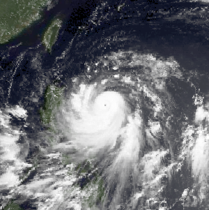
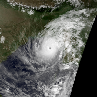
Typhoon Gay, also known as the Kavali Cyclone of 1989, was a small but powerful tropical cyclone which caused more than 800 fatalities in and around the Gulf of Thailand in November 1989. The worst typhoon to affect the Malay Peninsula in thirty-five years, Gay originated from a monsoon trough over the Gulf of Thailand in early November. Owing to favorable atmospheric conditions, the storm rapidly intensified, attaining winds over 120 km/h (75 mph) by 3 November. Later that day, Gay became the first typhoon since 1891 to make landfall in Thailand, striking Chumphon Province with winds of 185 km/h (115 mph). The small storm emerged into the Bay of Bengal and gradually reorganized over the following days as it approached southeastern India. On 8 November, Gay attained its peak intensity as a Category 5-equivalent cyclone with winds of 260 km/h (160 mph). The cyclone then moved ashore near Kavali, Andhra Pradesh. Rapid weakening ensued inland, and Gay dissipated over Maharashtra early on 10 November.

<span class="mw-page-title-main">2005 North Indian Ocean cyclone season</span> Cyclone season in the North Indian ocean

The 2005 North Indian Ocean cyclone season caused much devastation and many deaths in Southern India despite the storms’ weakness. The basin covers the Indian Ocean north of the equator as well as inland areas, sub-divided by the Arabian Sea and the Bay of Bengal. Although the season began early with two systems in January, the bulk of activity was confined from September to December. The official India Meteorological Department tracked 12 depressions in the basin, and the unofficial Joint Typhoon Warning Center (JTWC) monitored two additional storms. Three systems intensified into a cyclonic storm, which have sustained winds of at least 63 km/h (39 mph), at which point the IMD named them.

<span class="mw-page-title-main">1992 North Indian Ocean cyclone season</span>

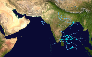
The 1992 North Indian Ocean cyclone season was unofficially the most active year on record for the basin, with 10 tropical storms developing, according to the Joint Typhoon Warning Center (JTWC). There are two main seas in the North Indian Ocean – the Bay of Bengal to the east of the Indian subcontinent – and the Arabian Sea to the west of India. The official Regional Specialized Meteorological Centre in this basin is the India Meteorological Department (IMD), while the JTWC releases unofficial advisories. An average of four to six storms form in the North Indian Ocean every season with peaks in May and November. Cyclones occurring between the meridians 45°E and 100°E are included in the season by the IMD.

<span class="mw-page-title-main">2006 North Indian Ocean cyclone season</span> North Indian Ocean tropical cyclone season

The 2006 North Indian Ocean cyclone season had no bounds, but cyclones tend to form between April and December, with peaks in May and November. These dates conventionally delimit the period of each year when most tropical cyclones form in the northern Indian Ocean.

<span class="mw-page-title-main">1977 Andhra Pradesh cyclone</span> 1977 weather event

The 1977 Andhra Pradesh cyclone was a devastating tropical cyclone that hit Andhra Pradesh in November 1977, killing at least 10,000 people. The worst affected areas were in the Krishna River delta region. The island of Diviseema, which was hit by a seven-metre-high (20 ft) storm surge, experienced a loss of life running into the thousands. The large loss of life prompted the establishment of early warning meteorological stations on the coast of Andhra Pradesh. Cyclone shelters and other measures for disaster management were also taken. A memorial, at the point of furthest advance of the tidal wave, near the town of Avanigadda, was built in memory of the people who died in the storm.

<span class="mw-page-title-main">1995 North Indian Ocean cyclone season</span> Cyclone season 1995 in the North Indian ocean

The 1995 North Indian Ocean cyclone season was below-average and was primarily confined to the autumn months, with the exception of three short-lived deep depressions in May. There were eight depressions in the basin, which is Indian Ocean north of the equator. The basin is subdivided between the Bay of Bengal and the Arabian Sea on the east and west coasts of India, respectively. Storms were tracked by the India Meteorological Department (IMD), which is the basin's Regional Specialized Meteorological Center, as well as the American-based Joint Typhoon Warning Center (JTWC) on an unofficial basis.

<span class="mw-page-title-main">1996 North Indian Ocean cyclone season</span> Cyclone season in the North Indian Ocean in 1996

The 1996 North Indian Ocean cyclone season featured several deadly tropical cyclones, with over 2,000 people killed during the year. The India Meteorological Department (IMD) – the Regional Specialized Meteorological Center for the northern Indian Ocean as recognized by the World Meteorological Organization – issued warnings for nine tropical cyclones in the region. Storms were also tracked on an unofficial basis by the American-based Joint Typhoon Warning Center, which observed one additional storm. The basin is split between the Bay of Bengal off the east coast of India and the Arabian Sea off the west coast. During the year, the activity was affected by the monsoon season, with most storms forming in June or after October.

<span class="mw-page-title-main">1989 North Indian Ocean cyclone season</span> Cyclone season in the North Indian ocean

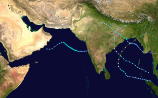
The 1989 North Indian Ocean cyclone season was a below-average season in annual cycle of tropical cyclone formation. Despite this, the season had the second highest Accumulated Cyclone Energy in the basin on record behind only 2019 The season has no official bounds but cyclones tend to form between April and December. These dates conventionally delimit the period of each year when most tropical cyclones form in the northern Indian Ocean. There are two main seas in the North Indian Ocean—the Bay of Bengal to the east of the Indian subcontinent and the Arabian Sea to the west of India. The official Regional Specialized Meteorological Centre in this basin is the India Meteorological Department (IMD), while the Joint Typhoon Warning Center (JTWC) releases unofficial advisories. An average of five tropical cyclones form in the North Indian Ocean every season with peaks in May and November. Cyclones occurring between the meridians 45°E and 100°E are included in the season by the IMD.

<span class="mw-page-title-main">Cyclone Keila</span> North Indian cyclone in 2011

Cyclonic Storm Keila was the first named storm of the 2011 North Indian Ocean cyclone season. A weak system for much of its duration, Keila developed in the western Arabian Sea in late October 2011, amid an area of marginally favorable conditions. On November 2, it briefly organized enough to be classified as a cyclonic storm, which has maximum sustained winds of at least 65 km/h (40 mph). Given the name Keila by the India Meteorological Department (IMD), the storm quickly moved ashore southern Oman near Salalah, and weakened while meandering over the country. The remnants soon after moved offshore, dissipating on November 4.

<span class="mw-page-title-main">Typhoon Clara (1981)</span> Pacific typhoon in 1981

Typhoon Clara, known in the Philippines as Typhoon Rubing, left flooding in the northern Philippines and southern China during September 1981. An area of disturbed weather was first detected on September 11 near Ponape. After moving westward, the system gradually became better organized and thunderstorm activity increased. On September 16, the system attained tropical storm status. Two days later, Clara attained typhoon intensity and subsequently began to deepen at a faster rate. On September 19, Clara reached maximum intensity, before making landfall along the northern tip of Luzon. Clara steadily weakened after interacting with land, but by late on September 20, Clara leveled off in intensity over the South China Sea. The next day, Clara moved ashore to the east-northeast of Hong Kong while still at typhoon intensity before rapidly dissipating over land.

<span class="mw-page-title-main">Cyclone Lehar</span> North Indian cyclone in 2013

Very Severe Cyclonic Storm Lehar was a tropical cyclone that primarily affected the Andaman and Nicobar Islands and the Indian state of Andhra Pradesh. Lehar was the second most intense tropical cyclone of the 2013 season, surpassed by Cyclone Phailin, as well as one of the two relatively strong cyclones that affected Southern India in November 2013, the other being Cyclone Helen.

<span class="mw-page-title-main">Cyclone Forrest</span> Pacific tropical storm and North Indian cyclone in 1992

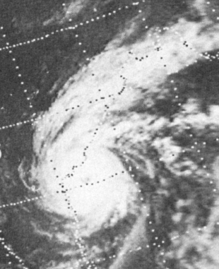
Extremely Severe Cyclonic Storm Forrest, also referred to as Tropical Storm Forrest while in the western Pacific basin before its Thai crossover, was a powerful tropical cyclone that prompted the evacuation of 600,000 people in Bangladesh in late November 1992. Originating from an area of disturbed weather near the Caroline Islands on November 9, Forrest was classified as a tropical depression three days later over the South China Sea. Tracking generally west, the system steadily organized into a tropical storm, passing Vietnam to the south, before striking Thailand along the Malay Peninsula on November 15. Once over the Bay of Bengal, Forrest turned northward on November 17 and significantly intensified. It reached its peak intensity on November 20 as a Category 4-equivalent cyclone on the Saffir–Simpson hurricane scale with winds of 230 km/h (140 mph). Hostile environmental conditions soon affected the cyclone as it turned abruptly east-northeastward. Forrest made landfall in northwestern Myanmar as a weakening system on November 21 before dissipating early the next day.

<span class="mw-page-title-main">Tropical Storm Tess</span> Pacific severe tropical storm in 1988

Severe Tropical Storm Tess known in the Philippines as Tropical Storm Welpring was the second of three tropical cyclones to directly impact the Philippines in a two-week time frame in 1988. An area of disturbed weather near the Philippines was first observed on November 1. Following an increase in organization, the disturbance was designated as a tropical cyclone on November 4. Moving west, Tess steadily strengthened due to favorable conditions aloft. During the evening of November 5, Tess was estimated to have achieved its highest intensity, with winds of 115 km/h (70 mph). Rapid weakening then ensured as Tess neared Vietnam, and after making landfall in the country on November 6, Tess dissipated the next day.

<span class="mw-page-title-main">Cyclone Nilofar</span> North Indian cyclone in 2014

Extremely Severe Cyclonic Storm Nilofar was, at the time, the third-strongest cyclone in the Arabian Sea. In late October 2014, it reached peak maximum sustained winds estimated between 205 km/h (125 mph) and 215 km/h (130 mph). The India Meteorological Department (IMD) named it Nilofar; the name refers to the water lily, and was suggested by Pakistan. The western fringes of the storm caused flash flooding in northeastern Oman, killing four people.

<span class="mw-page-title-main">October 1996 India cyclone</span> North Indian Ocean cyclone in 1996

The October 1996 India cyclone had an unusual and protracted path that spanned much of the northern Indian Ocean. It originated in a weather disturbance that formed on October 14 in the southern Bay of Bengal, off India's east coast. Moving westward, it struck Andhra Pradesh on October 17 as a well-defined low-pressure area. It crossed southern India and reorganized in the Arabian Sea off the western coast of India. The system developed into a depression on October 22 and quickly intensified while moving northward. By October 24, the cyclone approached hurricane intensity as it developed an eye, reaching peak winds of at least 110 km/h (70 mph). On October 25, the storm abruptly stalled and weakened off Gujarat, and progressed southwestward as a minimal storm. It was no longer classifiable as a tropical cyclone by October 28, although its remnants persisted until November 2 when they dissipated east of Somalia.

<span class="mw-page-title-main">1995 India cyclone</span> Category 1 North Indian tropical cyclone in 1995

The 1995 India cyclone was a tropical cyclone that struck southeastern India which later spawned a rare snowstorm in Nepal, triggering the deadliest mountain trekking incident in the country's history in November 1995. The storm originated from the monsoon trough on November 7 in the Bay of Bengal, east of India, becoming the penultimate storm of the 1995 North Indian Ocean cyclone season. Moving northwestward, the system gradually intensified while moving toward land, eventually developing an eye in the middle of the convection. Reaching peak winds of at least 120 km/h (75 mph), the India Meteorological Department (IMD) classified the system as a very severe cyclonic storm on November 8, in line with intensity estimates from the American-based Joint Typhoon Warning Center (JTWC). On November 9, the cyclone made landfall near the border of Andhra Pradesh and Orissa. A typical for most November storms, the system continued to the north and dissipated over Nepal on November 11.

<span class="mw-page-title-main">Typhoon Cary (1987)</span> Pacific typhoon in 1987

Typhoon Cary, known as Typhoon Ising in the Philippines, was the second of two tropical cyclones to affect Vietnam in a week. An area of disturbed weather developed southwest of Pohnpei on August 6, 1987. The system initially remained disorganized, but by August 14, Cary had attained tropical storm intensity. After initially moving north-northwest, Cary turned west-northwest, although intensification was slow to occur. On August 15, Cary was upgraded into a typhoon, and on August 17, the typhoon peaked in intensity. Typhoon Cary then made landfall in northern Luzon while at peak intensity. Across the Philippines, 954 houses were damaged and an additional 89 were destroyed, which left 55,567 people, or 13,247 families that were either homeless or otherwise sought shelter. Five people died in the country while damage totaled $5.58 million (1987 USD), including $1.45 million from agriculture and $4.13 million from infrastructure. The storm weakened over land, but re-intensified into a typhoon over the South China Sea. On August 21, Typhoon Cary passed just south of Hainan, where hundreds of homes were damaged but no fatalities occurred, and subsequently entered the Gulf of Tonkin. The storm weakened as it approached Vietnam, and on August 23, the storm dissipated inland over Laos. Across Vietnam, almost 40,000 ha of land were flooded or destroyed. Twenty people were killed and many others were injured.

<span class="mw-page-title-main">Typhoon Warren</span> Pacific typhoon in 1988

Typhoon Warren, known in the Philippines as Typhoon Huaning, struck the Philippines and China during July 1988. An area of disturbed weather developed within the vicinity of the Caroline Islands during the second week of July. A tropical depression developed southeast of Guam on July 12, and on the next day, intensified into a tropical storm. Tracking generally west-northwest, Warren deepened into a typhoon on July 14. The storm subsequently entered a period of rapid intensification, commencing with Warren reaching its highest intensity on July 16. The following evening, the typhoon brushed Luzon, resulting in a weakening trend, although Warren was still a typhoon when it made landfall near Shantou. Warren rapidly dissipated inland.

<span class="mw-page-title-main">1994 Bangladesh cyclone</span> Category 4 North Indian tropical cyclone in 1994

The 1994 Bangladesh cyclone was a powerful tropical cyclone in the Bay of Bengal. The cyclone closely followed the path, strength, and time of year of a deadly cyclone in 1991 that killed more than 138,000 people. The 1994 cyclone formed on April 29 as a depression, which organized and intensified significantly over the subsequent few days. On May 2, the cyclone attained winds of 215 km/h (135 mph), according to the India Meteorological Department (IMD). That day, the storm made landfall in southeastern Bangladesh, and rapidly weakened over land, before dissipating on May 3.

<span class="mw-page-title-main">Cyclone Phethai</span>

Severe Cyclonic Storm Phethai was a tropical cyclone which affected some portions of Sri Lanka and India during December 2018. The fourteenth depression, ninth deep depression, seventh cyclonic storm, and fifth severe cyclonic storm of the 2018 North Indian Ocean cyclone season, Phethai developed from an area of low pressure that formed over the Bay of Bengal on December 13. Having forecasted not to develop significantly, the depression then strengthened to a deep depression later that day before becoming a cyclonic storm on December 15. Phethai further intensified and peaked to a severe cyclonic storm, the following day. The system then steadily weakened due to land interaction and increasing wind shear, before making landfall as a disorganized system over Andhra Pradesh on December 17. It degenerated to an area of low-pressure inland later that day.

References

  1. RSMC New Delhi. Regional Specialised Meteorological Centre (RSMC) – Tropical Cyclones, New Delhi (PDF) (Report). India Meteorological Department. Archived from the original (PDF) on 12 April 2012. Retrieved 24 April 2015.
  2. Joint Typhoon Warning Center (2011). "Joint Typhoon Warning Center Mission Statement". United States Navy, United States Airforce. Archived from the original on 26 July 2007. Retrieved 30 November 2011.
  3. 1 2 3 4 5 6 7 8 9 Eric J. Trehubenko (1997). 1996 Annual Tropical Cyclone Report (PDF) (Report). Hagåtña, Guam: Joint Typhoon Warning Center. pp. 183, 234–235. Archived from the original (PDF) on 4 March 2016. Retrieved 6 November 2015.
  4. 1 2 "Tropical Cyclones" (PDF). Darwin Tropical Diagnostic Statement. Vol. 15, no. 11. Bureau of Meteorology. October 1996. pp. 2, 3. Archived from the original (PDF) on 17 November 2015. Retrieved 6 November 2015.
  5. 1 2 3 4 5 6 7 8 9 10 11 12 13 14 15 16 17 Report on cyclonic disturbances over north Indian Ocean during 1996 (PDF) (Report). India Meteorological Department. January 1996. Retrieved 6 November 2015.
  6. 1 2 Kenneth R. Knapp; Michael C. Kruk; David H. Levinson; Howard J. Diamond; Charles J. Neumann (2010). 1996 Missing (1996306N15097). The International Best Track Archive for Climate Stewardship (IBTrACS): Unifying tropical cyclone best track data (Report). Bulletin of the American Meteorological Society. Archived from the original on 20 November 2015. Retrieved 6 November 2015.
  7. 1 2 3 4 5 C.M. Muralidharan (2000). "A Description and Analysis of the Events Occurring at Sea and on Land 6 and 7 November 1996 in East Godavari District, Andhra Pradesh, India". Report of the Government of India/Government of Andhra Pradesh/FAO Workshop on Measure to Reduce the Loss of Life During Cyclones (Report). FAO Fisheries Report. Food and Agriculture Organization of the United Nations. pp. 36–38. ISSN   0429-9337.
  8. 1 2 3 4 5 6 7 8 9 Omer Farooq (9 November 1996). "Cyclone leaves death, disease and destruction in India". The Daily Gazette. Associated Press. Retrieved 10 November 2015.
  9. 1 2 3 4 5 6 Krishna Prasad; S. Sivanand (27 November 1996). "The Day Disaster Struck". The Outlook . Retrieved 12 November 2015.
  10. 1 2 "Battered by Cyclone, Indians Begin to Rebuild". The New York Times. 12 November 1996.  via Lexis Nexis (subscription required)
  11. "Cyclone victims should have been warned, say Indian newspapers". Agence France-Presse. 8 November 1996.  via Lexis Nexis (subscription required)
  12. 1 2 3 4 5 6 7 8 9 Technical Annex on a Proposed Loan and Credit to India for an Andhra Pradesh Hazard Mitigation and Emergency Cyclone Recovery Project (PDF) (Report). World Bank. 11 April 1997. pp. 5–7, 10–11, Attachment 11.
  13. 1 2 Madhu Nainan (9 November 1996). "Cyclone victims pick up the pieces". Agence France-Presse.  via Lexis Nexis (subscription required)
  14. 1 2 3 4 Omer Farooq (9 November 1996). "Death, Disease, Destruction from Cyclone in Southern India". Associated Press.  via Lexis Nexis (subscription required)
  15. 1 2 3 4 5 6 7 8 9 India: Cyclone IFRC situation report no. 2. International Federation of Red Cross and Red Crescent Societies (Report). ReliefWeb. 21 November 1996. Retrieved 6 November 2015.
  16. 1 2 3 4 5 "Tragedy revealed as water recedes". The News. Associated Press. 10 November 1996. Retrieved 10 November 2015.
  17. 1 2 "Cholera outbreak grips cyclone-hit Indian state". Agence France-Presse. 10 November 1996.  via Lexis Nexis (subscription required)
  18. 1 2 "India offers tax break for cyclone aid". United Press International. 10 November 1996.  via Lexis Nexis (subscription required)
  19. "Historical Exchange Rates". Oanda Corporation. 2015. Retrieved 6 November 2015.
  20. 1 2 3 "India Cyclone Death Toll May Exceed 2,000". ReliefWeb. Reuters. 11 November 1996. Retrieved 7 November 2015.
  21. 1 2 Omer Farooq (12 November 1996). "Feared Dead in Cyclone, Fishermen Return to India's South Coast". Associated Press.  via Lexis Nexis (subscription required)
  22. 1 2 India Cyclone Information Report No.2. United Nations Department of Humanitarian Affairs (Report). ReliefWeb. 15 November 1996. Retrieved 6 November 2015.
  23. Omer Farooq (7 November 1996). "Storm Hits India, State Executive Says Death Toll May Reach 2,000". Associated Press.  via Lexis Nexis (subscription required)
  24. "Traffic resumes in cyclone-ravaged India's south". Agence France-Presse. 9 November 1996.  via Lexis Nexis (subscription required)
  25. 1 2 India: Cyclone IFRC situation report no. 1. International Federation of Red Cross and Red Crescent Societies (Report). ReliefWeb. 13 November 1996. Retrieved 7 November 2015.
  26. India-Proposed Andhra Pradesh Hazard Mitigation and Emergency Cyclone Recovery Project (PDF) (Report). World Bank. 29 January 1997. Retrieved 13 November 2015.
  27. Dev Varam (9 November 1996). "Indian state battles to aid cyclone victims". Reuters.  via Lexis Nexis (subscription required)
  28. 1 2 3 "Milking A Tragedy?". The Outlook. 27 November 1996. Retrieved 12 November 2015.
  29. "Indian cyclone may have killed 1,000, says chief minister". Agence France-Presse. 8 November 1996.  via Lexis Nexis (subscription required)
  30. Silke Heuser (19 March 2004). "Implementation Completion Report (ICR) Review – A.p. Emerg. Cyclone". Archived from the original on 20 November 2015. Retrieved 13 November 2015.
1996 Andhra Pradesh cyclone
07B Nov 6 1996 0758Z.png
Satellite image of the storm prior to landfall in India on 6 November