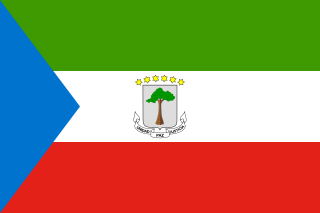
Equatorial Guinea, also rarely known as Equatoguinea, officially the Republic of Equatorial Guinea, is a country on the west coast of Central Africa, with an area of 28,000 square kilometres (11,000 sq mi). Formerly the colony of Spanish Guinea, its post-independence name refers to its location near both the Equator and in the African region of Guinea. As of 2021, the country had a population of 1,468,777, over 85% of whom are members of the Fang people, the country's dominant ethnic group. The Bubi people, indigenous to Bioko, are the second largest group at approximately 6.5% of the population.

The Republic of Equatorial Guinea is located in west central Africa. Bioko Island lies about 40 kilometers (24.9 mi) from Cameroon. Annobón Island lies about 595 kilometres (370 mi) southwest of Bioko Island. The larger continental region of Río Muni lies between Cameroon and Gabon on the mainland; it includes the islands of Corisco, Elobey Grande, Elobey Chico, and adjacent islets. The total land area is 28,051 km2 (10,831 sq mi). It has an Exclusive Economic Zone of 303,509 km2 (117,185 sq mi).

Gabon is a country in Central Africa, lying along the Atlantic Ocean, just south of the Bight of Biafra.

The Gulf of Guinea is the northeasternmost part of the tropical Atlantic Ocean from Cape Lopez in Gabon, north and west to Cape Palmas in Liberia. Null Island, defined as the intersection of the Equator and Prime Meridian, is in the gulf.
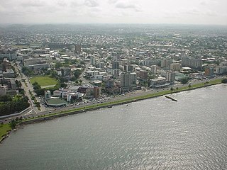
Libreville is the capital and largest city of Gabon. Occupying 65 square kilometres (25 sq mi) in the northwestern province of Estuaire, Libreville is a port on the Komo River, near the Gulf of Guinea. As of the 2013 census, its population was 703,904.

Equatorial Guinea's culture has been less documented than most African countries, and commercial recordings remain scarce.
Fang is a Central African language spoken by around 1 million people, most of them in Equatorial Guinea, and northern Gabon, where it is the dominant Bantu language; Fang is also spoken in southern Cameroon, the Republic of the Congo, and small fractions of the islands of São Tomé and Príncipe. It is related to the Bulu and Ewondo languages of southern Cameroon.

The South Region is located in the southwestern and south-central portion of the Republic of Cameroon. It is bordered to the east by the East Region, to the north by the Centre Region, to the northwest by the Littoral Region, to the west by the Gulf of Guinea, and to the south by the countries of Equatorial Guinea, Gabon, and Congo. The South occupies 47,720 km2 of territory, making it the fourth largest region in the nation. The major ethnic groups are the various Beti-Pahuin peoples, such as the Ewondo, Fang, and Bulu.
The Fang-Beti are a Bantu ethnic group located in rain forest regions of Cameroon, Republic of the Congo, Equatorial Guinea, Gabon, and São Tomé and Príncipe. Though they separate themselves into several individual clans, they all share a common origin, history and culture Estimated to be well over 8 million individuals in the early 21st century, they form the largest ethnic group in central Cameroon and its capital city of Yaoundé, in Gabon, and in Equatorial Guinea. Their Beti languages are mutually intelligible.

Annobón is a province of Equatorial Guinea. The province consists of the island of Annobón and its associated islets in the Gulf of Guinea. Annobón is the smallest province of Equatorial Guinea in both area and population. According to the 2015 census, Annobón had 5,314 inhabitants, a small population increase from the 5,008 registered by the 2001 census. The official language is Spanish but most of the inhabitants speak a creole form of Portuguese. The island's main industries are fishing and forestry.
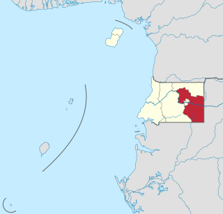
Wele-Nzas Province is a province in the eastern portion of continental Equatorial Guinea. Its capital is Mongomo. It borders the Equatoguinean provinces of Centro Sur to the west and Kié-Ntem to the north, with Gabon's Woleu-Ntem Province to the east and south. As of 2015, the population of Wele-Nzas was 192,017. It derives its name from the Benito River and the Piedra Nzas mountain range.
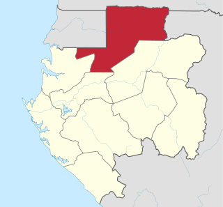
Woleu-Ntem is the northernmost of Gabon's nine provinces. It covers an area of 38,465 km2 and named after Woleu and Ntem rivers that cross it. The provincial capital is Oyem, which had a total of 60,685 inhabitants in 2013.

The individual member states of the African Union (AU) coordinate foreign policy through this agency, in addition to conducting their own international relations on a state-by-state basis. The AU represents the interests of African peoples at large in intergovernmental organizations (IGO's); for instance, it is a permanent observer at the United Nations' General Assembly.
The following outline is provided as an overview of and topical guide to Equatorial Guinea:

The following outline is provided as an overview and topical guide to Gabon :

The Atlantic Equatorial coastal forests, also known as the Congolian coastal forests, are a tropical moist broadleaf forest ecoregion of Central Africa, covering hills, plains, and mountains of the Atlantic coast of Cameroon, Equatorial Guinea, Gabon, Republic of the Congo, Angola, and Democratic Republic of the Congo.

The 10th parallel north is a circle of latitude that is 10 degrees north of the Earth's equatorial plane. It crosses Africa, the Indian Ocean, the Indian Subcontinent, Southeast Asia, the Pacific Ocean, Central America, South America and the Atlantic Ocean.
The Third Zone District of Moanda lies south of the city of Moanda, Gabon. It is isolated from the city by the Miosso Swamp and its only connection remains the Moanda-Bakoumba road, which passes between Mounts Moanda and Boundinga and continues to the border with Congo-Brazzaville.

The Kwasio language, also known as Ngumba / Mvumbo, Bujeba, and Gyele / Kola, is a language of Cameroon, spoken in the south along the coast and at the border with Equatorial Guinea by some 70,000 members of the Ngumba, Kwasio, Gyele and Mabi peoples. Many authors view Kwasio and the Gyele/Kola language as distinct. In the Ethnologue, the languages therefore receive different codes: Kwasio has the ISO 639-3 code nmg, while Gyele has the code gyi. The Kwasio, Ngumba, and Mabi are village farmers; the Gyele are nomadic Pygmy hunter-gatherers living in the rain forest.

Estuaire is the most populous of Gabon's nine provinces. It covers an area of 20,740 km2. The provincial capital is Akanda, but the largest city is Libreville, Gabon's national capital. The province is named for the Gabon Estuary, which lies at the heart of the province.


