A27 road

Last updated

UK road A27.svg
A27
A27 road map.png
Major junctions
West end Whiteparish (near Salisbury, Wiltshire)
Major intersectionsUK road A36.svg A36
UK-Motorway-M3.svg M3
UK road A33.svg A33
UK road A32.svg A32
UK-Motorway-M27.svg M27
UK-Motorway-M275.svg M275
UK road A3.svg A3
UK-Motorway-A3 (M).svg A3(M)
UK road A259.svg A259
UK road A29.svg A29
UK road A280.svg A280
UK road A24.svg A24
UK road A283.svg A283
UK road A23.svg A23
UK road A26.svg A26
UK road A22.svg A22
East end Pevensey (near Bexhill, East Sussex)
Location
Country United Kingdom
Primary
destinations
Southampton
Fareham
Portsmouth
Chichester
Littlehampton
Worthing
Brighton and Hove
Lewes
Eastbourne
Road network
UK road A26.svg A26 UK road A28.svg A28

The A27 is a major road in England. It runs from its junction with the A36 at Whiteparish (near Salisbury) in the county of Wiltshire, follows the south coast of Hampshire and West Sussex, and terminates at Pevensey (near Eastbourne and Bexhill) in East Sussex.

Contents

It is the westernmost road in Zone 2 in the UK road numbering system.

Between Portsmouth and Lewes, it is one of the busiest trunk roads in the UK.

History

Historically, for longer distance movement along the south coast, the M25 in combination with the M2, M20, M23 / A23, A3 / A3(M) and M3 has provided an attractive alternative to the actual south coast route of A259, A27 and M27. In 2002 an offpeak journey between Margate and Southampton via the M25 took 2 hours 30 minutes, and via the coastal route using the A259, A27 and M27 took 3 hours 50 minutes. [1] The reason the coastal route is so much slower than the M25 alternative is largely due to a series of bottlenecks on the A27. These include Chichester, Arundel, Worthing and Polegate. [2]

The British government announced, in its 2013 spending review, that it would go ahead with improvements to the Chichester bypass. [3] The Highways Agency said that the proposals would be subject to public consultation in July 2015. The preferred route would then be announced in September 2015 and the plan would be to start construction in February 2018 with a completion date of December 2019. [4] [5] [6] However the timescales were then revised. There was a six-week public consultation period during Spring 2016. The proposed construction would then commence in March 2019 with a completion date of March 2021. [7] After five options were published and two dropped the government cancelled the whole project on 28 February 2017, citing lack of support from local authorities as the main reason. [8] [9] Chichester Bypass is now scheduled to be included in "RIS3". [lower-alpha 1] A proposed scheme to bypass Lancing and Sompting (as well as other sections) was dropped in 1988. [11]

A proposed scheme to bypass Arundel was dropped in 2003, although the junction at the end of the dual carriageway has been partly made into an underpass. [12] [13] However, the scheme was relaunched in Spring 2018 when Highways England announced their preferred route, choosing a "a modified version of Option 5A". [14] Although the document claims 48% of respondents support this option, there are worries that the new road may damage ancient woodland in the South Downs National Park. [15] With protests about the western end destroying an ancient woodland, Highways England consulted further in October 2019 and in October 2020 announced a new preferred route that is 8.8 kilometres (5.5 mi) long and avoids the South Downs National Park and ancient woodland entirely. Plans now deferred until 2025-2030. [16] [17]

At Worthing, where the possibility of a bypass has often been discussed since 1967, even getting as far as passing the inspector's report at a public inquiry, the plan was dropped in 1996 following rising costs. [18] Arundel and Worthing are both areas of known traffic congestion during times of peak usage. [2] [19] The proposed improvements for Worthing could begin in 2025 and be completed by 2027. [lower-alpha 1]

A bridge over the level crossing at Beddingham was completed on 22 August 2008. [20] The original proposal called for a dual carriageway standard link with a bridge over the crossing. [21] However, the actual project involved improving the original single carriageway road by providing two lanes westbound and one lane eastbound between the Southerham and Beddingham roundabouts. [20]

Despite the limited improvements to the A27, it is still substantially quicker (usually more than an hour difference) to travel from Southampton to Margate via the M25 route compared to the coast route of A259, A27 and M27. [22] [23]

Because of all the delays along its route, according to West Sussex County Council, the A27 is the most unreliable all-purpose trunk road in England. [24] Further, it is widely considered by businesses on the coast to cost money and inhibit economic performance due to its unreliability and frequent congestion. [25]

Highways England commissioned a report by "Transport Focus" to undertake road user priorities. The South Central route, that is largely the A27, was one of the lower rated routes with 50% of users experiencing problems. Out of a list of strategic routes across the whole of England only two were rated worse than the South Central route: the M25 to Solent route (61%) and the London Orbital and M23 to Gatwick (58%). Further Highways England identified the A27 between Lancing and the A24; between Arundel and the A284; between the A23 and Polegate; also around Chichester as being some of worst performing links in the country for safety issues. [26] One accident victim was Actor Desmond Llewelyn, who portrayed Q in a large portion of the James Bond film series and was fatally injured in a car accident on the A27 in 1999, at Firle, on the A23 to Polegate section. [27]

There are several sections of the A27 that fall inside the Highways Agency nationwide top 250 collision rankings: [28]

Serious incidents

Shoreham Airshow crash

At the Shoreham Airshow on 22 August 2015, a Hawker Hunter crashed into the A27, striking several vehicles and killing eleven people. [29] The road was completely closed for eight days and did not fully reopen until 16 September 2015. [30]

Flooding

In November 2022, during the outbreak of flooding, the road near Chichester, Emsworth and Havant was extensively covered with floodwater. 20 cars were trapped on this section of the road. [31]

Description

A27 near Brighton and Hove, East Sussex A27 near Brighton and Hove East Sussex.jpg
A27 near Brighton and Hove, East Sussex
A27 north of Portsmouth, at its junction with the M27 A27 near Hilsea, Portsmouth, UK.jpg
A27 north of Portsmouth, at its junction with the M27

The road starts at its junction with the A36 at Whiteparish. It runs through Romsey, Chilworth, at which point it follows a Roman Road, Swaythling, West End and Bursledon. It then closely parallels the south coast and travels on via Fareham, Cosham, Havant, Chichester, Arundel, Worthing, Lancing, Shoreham-by-Sea, Hove, Brighton, Falmer, Lewes and Polegate where it then terminates at Pevensey in East Sussex. [32]

A section of the A27 running from the eastern end of the M27 to the end of the road at Pevensey forms part of, what was known as, the South Coast Trunk Road. Much of the road has been improved to dual carriageway standard, with the westernmost section of the trunk portion even having as much as four lanes plus a hard shoulder in each direction, and on a motorway alignment with grade-separated junctions. This is perhaps a reflection that the M27 was once proposed to run as far as Chichester. [33]

The road runs east from Portsmouth to Havant then on to the Warblington/ Emsworth exit. Beyond Warblington the dual carriageway east has no junctions in it until it reaches Chichester, where the by-pass has five roundabouts and one traffic signal controlled junction, that disrupt the mainline flow of the road. [4] [34] The Chichester by-pass is regularly subject to congestion [35] and although a public inquiry has proposed improvements, those improvements are currently on hold. [4]

East of Chichester the road largely retains a two-lane dual-carriageway standard. There are, however a couple of sections of single-carriageway; at Arundel and at Worthing. [36] These are both areas of known traffic congestion during times of peak usage. [37]

At the junction of the A27 and the A24, the A27 has a brief section where the road is designated 'A27' and 'A24' before continuing from the 'Grove Lodge' roundabout where the road is named "Upper Brighton Road". [32] After Worthing, the A27 passes Sompting on the Sompting Bypass before passing through Lancing where there are traffic lights and a roundabout which disrupt traffic flow. Just before the road crosses the River Adur near Shoreham via the 'Shoreham flyover' (constructed 1968-70 [38] ), there is a traffic light-controlled intersection close to Lancing College and the headquarters of Ricardo plc which was the scene of the multiple-fatality Shoreham Airshow crash in 2015. [39] After the 'flyover' over the Adur, the A27 then runs past the Holmbush interchange (Shoreham-by-Sea) and on through the Southwick Hill Tunnel, at that point entering the City of Brighton and Hove, traditionally (though no longer administratively) part of East Sussex.

Later, it passes Brighton  — where it is known as the Brighton Bypass [40]  — and around the South Downs. The junction of the A23 and the A27 is often slow in the morning rush hour.

It then passes around Falmer with this section of road having three lanes in each direction but loses the third lane later. When Brighton and Hove Albion play at home this section can become congested due to its proximity to Falmer Stadium. The road passes into East Sussex proper just to the west of the Falmer junction.

Afterwards, it passes south of Lewes where it meets the A26 road to Newhaven.

Here, the road becomes a single carriageway standard and formerly crossed a level crossing until it was bypassed by a bridge which opened in 2008. The South Coast Multi-Modal Study (SoCoMMS) recommended a dual carriageway, but the Highways Agency built it to a cheaper single-carriageway standard. Plans are still proposed for upgrading this later. [36] [41]

The road afterwards reverts to a dual carriageway with access to the A22, which provides links to Eastbourne and Hailsham.

The road then once again becomes a single carriageway near Pevensey, where the road ends, and the South Coast Trunk Road transfers over to the A259; this coast road starts in Emsworth and shadows the route of the A27.

Work on the contentious Bexhill to Hastings link road commenced in early 2013 and was completed in late 2015. The road provides a more direct link from the A27 to the A28 road via the A259 road. [42]

Landmarks on the route

A27 crossing the Adur flyover, near Shoreham, West Sussex Adur flyover road junction aerial photo Aug2009.JPG
A27 crossing the Adur flyover, near Shoreham, West Sussex

Proposed developments

The National Highways Agency state on their website that the A27 is the only east–west trunk road south of the M25 and it serves a population of more than 750,000 people along the south coast. They also say that safety is a problem along the A27 with many accidents and incidents along its length. To improve its safety and serviceability they intend to make improvements to the road. [43] This includes:

Junctions

CountyLocationmikmCoordDestinationsNotes
Wiltshire 00 [coord 1] UK road A36.svg A36 - Southampton, Salisbury
Hampshire Romsey 8.513.7 [coord 2] UK road A3090.svg A3090 - Bournemouth, Ringwood, Southampton, Ower, Cadnam, Romsey, Winchester
9.315.0 [coord 3] UK road A3090.svg A3090 - Winchester, Stockbridge
10.316.6 [coord 4] UK road A3057.svg A3057 - Southampton, Nursling, Rownhams, Lordshill
Southampton 15.124.3 [coord 5] UK road A33.svg A33 - Southampton

UK-Motorway-M3.svg M3 - London, Eastleigh, Winchester

16.626.7 [coord 6] UK road A335.svg A335 - Eastleigh, Southampton Center Detour along Stoneham lane and the A335 is required to continue along the A27
19.932.1 [coord 7] UK road A334.svg A334 - Southampton, Bitterne, Botley, Hedge End
21.234.2 [coord 8] UK road A3024.svg A3024 - Portsmouth, Southampton, Bitterne

UK road A3025.svg A3025 - Woolston

Park Gate 24.539.4 [coord 9] UK road A3051.svg A3051 - Botley
24.839.9 [coord 10] UK road A27.svg A27 - Fareham, Titchfield, Warsash Road splits into two branches
North branch
25.240.6 [coord 11] UK-Motorway-M27.svg M27 - Southampton, Winchester, Portsmouth, Fareham
South branch
Fareham 29.146.8 [coord 12] UK road A32.svg A32 - Gosport
29.747.3 [coord 13] UK road A32.svg A32 - Alton, Wickham Road splits into two branches
North branch
30.348.3 [coord 14] UK-Motorway-M27.svg M27 - Southampton, Alton, Portsmouth, Brighton
East branch
Portsmouth 33.353.1 [coord 15] UK-Motorway-M27.svg M27 - Portsmouth, Southampton

UK road A3.svg A3 - Cosham, Paulsgrove, Waterlooville

34.354.6 [coord 16] UK-Motorway-M27.svg M27 - Portsmouth, Southampton, Fareham

UK road A3.svg A3 - Hilsea
UK road A397.svg A397 - Cosham, Waterlooville

no access from M27 to A27 going west and vice versa
35.657.3 [coord 17] UK road A2030.svg A2030 - Farlington, Drayton, Portsmouth, Southsea, Fratton, Hilsea
1.000 mi = 1.609 km; 1.000 km = 0.621 mi

*Ceremonial Counties

Coordinate list
  1. 51°00′44″N1°40′51″W / 51.0123°N 1.6809°W
  2. 50°59′00″N1°30′22″W / 50.9834°N 1.5060°W
  3. 50°59′17″N1°29′22″W / 50.9880°N 1.4895°W
  4. 50°58′34″N1°28′51″W / 50.9761°N 1.4809°W
  5. 50°57′09″N1°24′14″W / 50.9524°N 1.4039°W
  6. 50°56′32″N1°22′33″W / 50.9423°N 1.3758°W
  7. 50°54′51″N1°19′40″W / 50.9143°N 1.3277°W
  8. 50°53′47″N1°19′09″W / 50.8963°N 1.3191°W
  9. 50°52′14″N1°15′53″W / 50.8706°N 1.2646°W
  10. 50°52′08″N1°15′17″W / 50.8690°N 1.2547°W
  11. 50°52′28″N1°15′09″W / 50.8744°N 1.2525°W
  12. 50°51′02″N1°10′39″W / 50.8505°N 1.1774°W
  13. 50°51′12″N1°10′03″W / 50.8532°N 1.1675°W
  14. 50°51′36″N1°09′27″W / 50.8600°N 1.1576°W
  15. 50°50′45″N1°05′17″W / 50.8459°N 1.0881°W
  16. 50°50′15″N1°04′22″W / 50.8375°N 1.0728°W
  17. 50°50′05″N1°02′36″W / 50.8347°N 1.0433°W


Notes

  1. 1 2 3 4 RP – Road Period. RIS - Road Investment Strategy.
    * RP1 is the financial years 2015/16 to 2019/20 inclusive.
    * RP2 is 2020/21 to 2024/25.
    * RP3 will commence with 2025/26, which means it is planned to be constructed between 2025 & 2030: consultation should begin after 2023.
    * RIS3 - (The "Third Road Investment Strategy") includes 32 schemes,that the Highways Agency has identified by working closely with the Department for Transport (DfT),that will be developed as part of a pipeline of schemes that may be built in the third road investment period, which runs from 2025 to 2030. [10]

Related Research Articles

<span class="mw-page-title-main">M25 motorway</span> Circular motorway around Greater London

The M25 or London Orbital Motorway is a major road encircling most of Greater London. The 117-mile (188-kilometre) motorway is one of the most important roads in the UK and one of the busiest. Margaret Thatcher opened the final section in 1986, making the M25 the longest ring road in Europe upon opening. The Dartford Crossing completes the orbital route but is not classed as motorway; it is classed as a trunk road and designated as the A282. In some cases, including notable legal contexts such as the Communications Act 2003, the M25 is used as a de facto alternative boundary for Greater London.

<span class="mw-page-title-main">Arundel</span> Market town in West Sussex, England

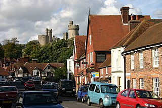
Arundel is a market town and civil parish in the Arun District of the South Downs, West Sussex, England.

<span class="mw-page-title-main">A3 road</span> London to Portsmouth road in England

The A3, known as the Portsmouth Road or London Road in sections, is a major road connecting the City of London and Portsmouth passing close to Kingston upon Thames, Guildford, Haslemere and Petersfield. For much of its 67-mile (108 km) length, it is classified as a trunk road and therefore managed by National Highways. Almost all of the road has been built to dual carriageway standards or wider. Apart from bypass sections in London, the road travels in a southwest direction and, after Liss, south-southwest.

The A1, also known as the Great North Road, is the longest numbered road in the United Kingdom, at 410 miles (660 km). It connects London, the capital of England, with Edinburgh, the capital of Scotland. The numbering system for A-roads, devised in the early 1920s, was based around patterns of roads radiating from two hubs at London and Edinburgh. The first number in the system, A1, was given to the most important part of that system: the road from London to Edinburgh, joining the two central points of the system and linking the UK's (then) two mainland capital cities. It passes through or near north London, Hatfield, Welwyn Garden City, Stevenage, Baldock, Letchworth Garden City, Biggleswade, Eaton Socon, Buckden, Peterborough, Stamford, Grantham, Newark-on-Trent, Retford, Doncaster, Pontefract, York, Wetherby, Ripon, Darlington, Durham, Gateshead, Newcastle upon Tyne, Morpeth, Alnwick and Berwick-upon-Tweed.

<span class="mw-page-title-main">A23 road</span> Major road in the United Kingdom

The A23 road is a major road in the United Kingdom between London and Brighton, East Sussex, England. It is managed by Transport for London for the section inside the Greater London boundary, Surrey County Council and West Sussex County Council for the section shadowed by the M23 motorway, National Highways between the M23 and Patcham, and by Brighton and Hove Council from the A27 to the centre of Brighton.

<span class="mw-page-title-main">M23 motorway</span> Road in Surrey and Sussex, England

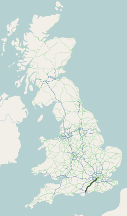
The M23 is a motorway in the United Kingdom, running from the south of Hooley in Surrey, where it splits from the A23, to Pease Pottage, south of Crawley in West Sussex where it rejoins the A23. The northern end of the motorway starts on what is effectively a 2-mile (3.2 km) spur north of junction 7 of the M25 motorway. From Hooley it runs for 17 miles (27 km) past Redhill, Gatwick Airport and Crawley. A spur runs from junction 9 to Gatwick Airport.

<span class="mw-page-title-main">M27 motorway</span> Motorway in Hampshire, England

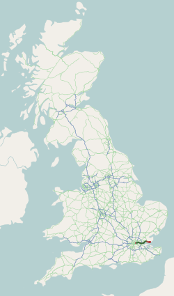
The M27 is a motorway in Hampshire, England. It is 27.9 miles (44.9 km) long and runs between Cadnam and Portsmouth. It was opened in stages between 1975 and 1983, providing the largest two urban areas in Hampshire with a direct motorway link. An extension into the county of West Sussex was planned but never constructed. A number of smaller motorways were proposed, connecting the city centres of Southampton and Portsmouth to the motorway; of these only the M271 and M275 were built. Three sections of the M27 have since been widened to four lanes each way, the first between junctions 7 and 8, the second between junctions 3 and 4, and the third begins at the slip road where junction 11 joins until mid-way to junction 12.

<span class="mw-page-title-main">A12 road (England)</span> Road in England

The A12 is a major road in Eastern England. It runs north-east/south-west between London and the coastal town of Lowestoft in the north-eastern corner of Suffolk, following a similar route to the Great Eastern Main Line until Ipswich. A section of the road between Lowestoft and Great Yarmouth became part of the A47 in 2017. Between the junctions with the M25 and the A14, the A12 forms part of the unsigned Euroroute E30. Unlike most A roads, this section of the A12, together with the A14 and the A55, has junction numbers as if it were a motorway.

<span class="mw-page-title-main">A13 road (England)</span> Major road in England

The A13 is a major road in England linking Central London with east London and south Essex. Its route is similar to that of the London, Tilbury and Southend line via Rainham, Grays, Tilbury, Stanford-Le-Hope & Pitsea, and runs the entire length of the northern Thames Gateway area, terminating on the Thames Estuary at Shoeburyness. It is a trunk road between London and the Tilbury junction, a primary route between there and Sadlers Hall Farm near South Benfleet, and a non-primary route between there and Shoeburyness.

<span class="mw-page-title-main">A21 road (England)</span> Major road in southern England running from London to Hastings

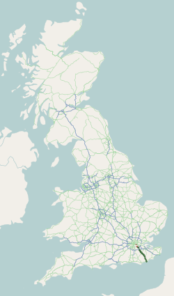
The A21 is a trunk road in Southern England, one of several which connect London and various commuter towns to the south coast. It provides a link to Hastings, East Sussex and parts of Kent. Half of the distance covered is over gently undulating terrain, with some hills and bends. Often traffic is slow-moving, particularly on weekdays on the short single carriageway stretches; and in summer with holiday traffic. Because of this, people have described the A21 as "a joke" and businesspeople have been reported to "hate coming down the A21". There have been many proposals to upgrade parts of the A21 in response to this.

<span class="mw-page-title-main">A31 road</span> Major trunk road in southern England

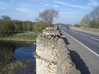
The A31 is a major trunk road in southern England that runs from Guildford in Surrey to Bere Regis in Dorset. Its most well known section is the Hog's Back, a hilly ridge forming part of the North Downs, in the Surrey stretch between Guildford and Farnham.

<span class="mw-page-title-main">A259 road</span> Road in England

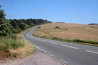
The A259 is a road on the south coast of England passing through Hampshire, West Sussex, East Sussex, and Kent, and is the longest Zone 2 A road in Great Britain. The main part of the road connects Brighton, Peacehaven, Eastbourne, Hastings, Rye, and Folkestone.

<span class="mw-page-title-main">A428 road</span> Road in England

The A428 road is a major road in central and eastern England. It runs between the cities of Coventry and Cambridge by way of the county towns of Northampton and Bedford. Together with the A421,, the eastern section of the A428 forms the route between Cambridge and Oxford. The A428 was formerly part of the main route from Birmingham to Felixstowe before the A14 was fully opened in 1993.

<span class="mw-page-title-main">A26 road</span> Road in England

The A26 road is a primary route in the southeast of England, going from Maidstone to Newhaven through the counties of Kent and East Sussex. The road is almost entirely single carriageway with one lane on each side, although parts of the road are three lanes, with the middle lane switching sides for overtaking and right turns.

<span class="mw-page-title-main">Arundel railway station</span> Railway station in West Sussex, England

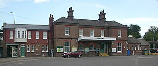
Arundel railway station serves the market town of Arundel in West Sussex. The station is on the eastern side of the town, about 550 yards (500 m) from the High Street, across the River Arun. It is 58 miles 28 chains (93.9 km) down the line from London Bridge via Redhill.

<span class="mw-page-title-main">A556 road</span> Road in Cheshire

The A556 is a road in England which extends from the village of Delamere in Cheshire West and Chester to the Bowdon Interchange in Cheshire East, bordering Greater Manchester. The road contains a mixture of single and dual carriageway sections and forms a large part of the route between Manchester and Chester. It also acts as a major access route to Chester/North Wales to the west and to Manchester to the east for the conurbation of towns and villages around the Dane Valley centering on Winsford and Northwich. The central part, which forms the Northwich Bypass between Davenham and Lostock Gralam, suffers because of the amount of commuter traffic from this area. The part of the route between the M6 motorway Junction 19 and the M56 motorway Junction 7 is a major route into Manchester and has been recently upgraded to a four-lane dual carriageway.

<span class="mw-page-title-main">A286 road</span> Road in the south east of England

The A286 is an A class road in the south of England, from its northernmost point in Milford, Surrey, to Birdham, West Sussex. It passes through the market towns of Haslemere and Midhurst, and the cathedral city of Chichester. The road is mostly single carriageway, with a small dual carriageway section as part of the Chichester ring road.

The South Coast Trunk Road is a former designation of a 222-mile (357 km) long route in southern England, sometimes called the Folkestone to Honiton trunk route. It is made up of several numbered roads :

References

  1. "South Coast Corridor Multi-Modal Study" (PDF). UK Government. 2002. p. 16. Archived from the original (PDF) on 2 June 2013. Retrieved 22 March 2012.
  2. 1 2 "South Coast Corridor Multi-Modal Study" (PDF). UK Government. 2002. p. 29. Archived from the original (PDF) on 2 June 2013. Retrieved 22 March 2012.
  3. "George Osborne commits to A27 works at Chichester". Chichester: Chichester Observer. Archived from the original on 8 March 2017. Retrieved 27 June 2013.
  4. 1 2 3 "A27 Chichester Improvement". Highways Agency. Archived from the original on 6 June 2011. Retrieved 8 June 2011.
  5. "Arundel Bypass review". Littlehampton Gazette. Retrieved 8 July 2013.
  6. "West Sussex A27 Action Plan". Chichester: WSCC. Retrieved 11 December 2013.
  7. "A27 Chichester Improvement". Highways Agency. Archived from the original on 31 January 2016. Retrieved 25 January 2016.
  8. "A27 Chichester Improvement". Highways Agency. Retrieved 6 March 2017.
  9. "A27 upgrade cancelled". Chichester Observer. Retrieved 6 March 2017.
  10. Department of Transport (2020). Road Investment Strategy 2020-2025 (PDF). Department of Transport. ISBN   978-1-5286-1678-2 . Retrieved 20 January 2021.
  11. "A27 BY-Pass project October 1988". Archived from the original on 4 March 2016. Retrieved 15 May 2013.
  12. "A27 upgrade calls". Chichester Observer. Retrieved 16 May 2011.
  13. "Arundel Bypass — Hansard". UK Government. 2000. Retrieved 7 February 2013.
  14. "A27 Arundel Bypass Preferred route announcement" (PDF). Highways England. Retrieved 16 July 2018.
  15. "Highways England reveals £250m Arundel bypass route". BBC News. 11 May 2018. Retrieved 11 May 2018.
  16. National Highways (2022). "A27 Arundel bypass". Birmingham: National Highways. Retrieved 24 April 2023.
  17. "Arundel Bypass". Highways Agency. 7 May 2020. Retrieved 23 June 2022.
  18. "Highway to Hell". The Argus. Worthing. 2012. Retrieved 7 February 2013.
  19. "West Sussex Transport Plan 2011-2026". West Sussex County Council. p. 29. Retrieved 7 February 2013.
  20. 1 2 "A27 Southerham to Beddingham". Highways Agency. Archived from the original on 5 June 2011. Retrieved 8 June 2011.
  21. "South Coast Corridor Multi-Modal Study" (PDF). UK Government. 2002. pp. 137–138. Archived from the original (PDF) on 2 June 2013. Retrieved 23 March 2012.
  22. "Southampton to Margate via M25". Google Maps. Retrieved 23 March 2012.
  23. "Southampton to Margate via A27". Google Maps. Retrieved 23 March 2012.
  24. "West Sussex Transport Plan 2011-2026". West Sussex County Council. p. 28. Retrieved 24 March 2012.
  25. "West Sussex Transport Plan 2011-2026". p. V. Retrieved 24 March 2012.
  26. "South Coast Central Route Strategy March 2017" (PDF). Highways England. 2017. Retrieved 18 August 2018.
  27. "Road death of Q actor accidental". The Guardian. London, United Kingdom. 14 June 2000. Retrieved 1 February 2013.
  28. "A27 CORRIDOR FEASIBILITY STUDY REPORT 1 OF 3: EVIDENCE REPORT" (PDF). Highways Agency. 2015. p. 36. Retrieved 13 November 2018.
  29. "Shoreham air crash death toll 'rises to 11'". BBC News. 23 August 2015. Retrieved 27 August 2015.
  30. "Shoreham A27 fully reopens after air crash". BBC News. 16 September 2015. Retrieved 16 June 2017.
  31. Freddie Webb (18 November 2022). "A27 flooding: 20 cars marooned in floodwater as weather causes chaos in Havant, Emsworth and Chichester". Portsmouth News. Retrieved 18 November 2022.
  32. 1 2 "A27 route". Google Maps. Retrieved 7 February 2013.
  33. "Map of Original Plans for M27". Pathetic Motorways. Retrieved 21 March 2012.
  34. Google map of Chichester retrieved 3 March 2012
  35. Typical road conditions on Chichester bypass. Google maps. Retrieved 4 June 2022
  36. 1 2 "South Coast Corridor Multi-Modal Study" (PDF). UK Government. 2002. pp. 21–22. Archived from the original (PDF) on 2 June 2013. Retrieved 21 March 2012.
  37. "Those A27 traffic jams have to ease". The Argus. Retrieved 8 June 2011.
  38. "A27 flyover under construction in 1969 near to Shoreham Airport". geograph.org.uk. Retrieved 24 August 2015.
  39. "Shoreham air crash death toll 'rises to 11'". BBC News. 2015. Retrieved 24 August 2015.
  40. By-pass: First proposed in 1932, My Brighton and Hove, Tim Carder, 1990
  41. "A27 Southerham to Beddingham". Highways agency. Archived from the original on 10 August 2012. Retrieved 1 February 2013.
  42. "Bexhill-Hastings road-protest". Guardian Newspapers. 28 January 2013. Retrieved 3 February 2013.
  43. National Highways (2017). "A27 Schemes". Birmingham: National Highways. Retrieved 2 May 2022.
  44. National Highways (2022). "A27 Arundel bypass". Birmingham: National Highways. Retrieved 24 April 2023.
  45. National Highways (2022). "A27 Worthing and Lancing improvements". Birmingham: National Highways. Retrieved 24 April 2023.
  46. National Highways (2017). "A27 Chichester Bypass". Birmingham: National Highways. Retrieved 2 May 2022.

50°52′N0°36′W / 50.86°N 0.60°W / 50.86; -0.60