The lands of Argyle prior to becoming the town were used as hunting and fishing grounds for Native American Mohicans and subsequently the Mohawk tribes although Huron and Iroquois tribes may also have hunted here.[5] During the period 1628 to 1664, the Mohawk tribe had a near exclusive fur trading monopoly with the Dutch New Netherland Colony based at nearby Fort Orange; now present day Albany. The town of Argyle was formed from the Argyll Patent of 1764 while still in Great Britain's Albany County, Province of New York and became a town in Charlotte County when that county was created on 24 March 1772.
During the American Revolution, citizens of the town had divided loyalties between the Crown and the Rebel cause. Records indicate at least 95 men with Argyle ties joined the American militia.[6] Many settlers may have been influenced by the killings of Jane McCrae in Fort Edward and the John Allen family in South Argyle prior to the Battle of Saratoga in 1777. During the time of the 9th New York State Legislature, Argyle was officially formed as a town on 23 March 1786.[7] Since many of the original settlers were from Argyll, Scotland, they adopted the name of their native land to the town. Although population growth was slow, the town was the most populous in the county by 1790.
In 1803, part of the town in the south-east portion near Cossayuna Lake was used to establish the new Town of Greenwich. In April 1818, an additional portion of the town in the north-west corner along the Hudson River was taken by New York State legislative act to establish the Town of Fort Edward.[7]
According to the first census of the United States in 1790, a small number of Argyle residents, along with those from other towns in New York held enslaved people prior to the final abolition of slavery in New York State on 5 July 1827. In 1790, 14 enslaved were reported in the Argyle census count, 29 in 1800, and 15 in 1810. In the early- to mid-1800's, Argyle was also home to abolitionists and the Ransom Stiles home and the County Poor House were believed to be stops on the underground railroad for southern slaves fleeing to Canada.[8]
During the American Civil War, approximately 90 men of Argyle enlisted with the 123rd New York Volunteer Infantry Regiment Company F (Washington Country Regiment), and 37 men with the 93rd New York Infantry Regiment, according to the New York State Military Museum. Additional New York volunteer infantry regiments which, at times, contained soldiers from Argyle according to "The History of Washington County" published in 1878, were the 22nd, 43rd, 44th, and 96th Infantry Regiments and the 2nd Cavalry and Harris Light Cavalry units. At least four additional men with Argyle ties enlisted with the 20th, 26th and 31st New York Colored Infantry Regiments and 54th Massachusetts Infantry Regiment.[9]
Voters in Argyle overwhelmingly passed four resolutions on 5 November 2019 allowing alcohol to be sold within the Town and Village ending Argyle's "dry" status which it had maintained since a few years after the repeal of Prohibition.[10] Previously Argyle was the largest dry town in New York State.[11]
The U.S. National Weather Service confirmed an EF1 tornado touched down near the hamlet of Goose Island on Monday, 10 August 2020. Damage to roofs and sidings of nearby homes was limited and no injuries were reported, although many tree trunks were snapped or uprooted.[12] According to TornadoHistoryProject.com, at least five tornadoes have been confirmed touching down in Washington County since 1950, although this is the first to be confirmed within Argyle during that time.
The Town of Argyle was near the path of totality (98.5%) during the Solar eclipse of April 8, 2024 according to the WEB site timeanddata.com. The time of maximum solar eclipse in Argyle was at 3:27.05 pm and was viewed with mostly clear weather.
Geography
According to the United States Census Bureau, the town has a total area of 57.8sqmi (150km2), of which 56.7sqmi (147km2) is land and 1.1sqmi (2.8km2) (1.92%) is water. The town mainly lies along the narrow northern ridge of the Taconic Mountains between the Hudson River and New York's border with the State of Vermont. In the western area of the town, farmland and small wooded lots are considered part of the Hudson River valley. A portion of these farmlands are also within the Washington County Grasslands,[13] an approximately 13,000 acre area which is a winter roosting site for state endangered short-eared owls; winter and breeding ground for other threatened and declining grassland birds, including Northern Harrier, Horned Lark, Upland Sandpiper, Eastern Bluebirds and Bobolinks. Snowy Owls are also regular visitors.
In the eastern part of the town, elevations increase, with several mountains reaching over 1,000 feet in height; with the highest being a few feet over 1,120 feet in height north of the hamlet of Goose Island. Two lakes, which both have extensive seasonal camps and year-round homes, are in this portion of the town; the spring-fed Summit Lake and further to the east, the larger Cossayuna Lake. From many locations in Argyle, the Adirondack Mountains can be viewed to the north and west and the Green Mountains of Vermont can be viewed to the east.
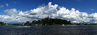
View from Argyle's Street Road looking WNW at the Hudson Valley and the nearby Adirondack Mountains.Panoramic View of Argyle, New York; June 2018
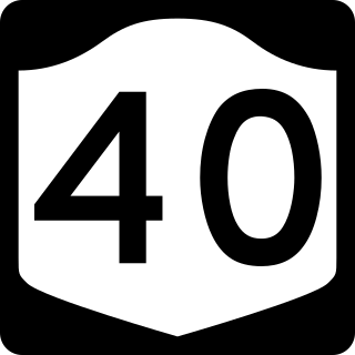
NY Route 40 is a north–south highway in the town and NY Route 197 is an east–west highway leading to/from nearby Fort Edward.
As of the census[4] of 2000, there were 3,688 people, 1,313 households, and 1,000 families residing in the town. The population density was 65.1 peopleper square mile (25.1 people/km2). There were 1,798 housing units at an average density of 31.7 per square mile (12.2/km2). The racial makeup of the town was 98.94% White, 0.22% Black or African American, 0.03% Native American, 0.03% Asian, 0.27% from other races, and 0.52% from two or more races. Hispanic or Latino of any race were 1.03% of the population.
There were 1,313 households, out of which 37.2% had children under the age of 18 living with them, 63.4% were married couples living together, 8.4% had a female householder with no husband present, and 23.8% were non-families. 17.6% of all households were made up of individuals, and 6.9% had someone living alone who was 65 years of age or older. The average household size was 2.71 and the average family size was 3.07.
In the town, the population was spread out, with 26.5% under the age of 18, 6.3% from 18 to 24, 29.0% from 25 to 44, 24.9% from 45 to 64, and 13.3% who were 65 years of age or older. The median age was 38 years. For every 100 females, there were 94.8 males. For every 100 females age 18 and over, there were 91.8 males.
The median income for a household in the town was $41,133, and the median income for a family was $44,414. Males had a median income of $32,253 versus $21,250 for females. The per capita income for the town was $20,403. About 5.3% of families and 7.6% of the population were below the poverty line, including 11.3% of those under age 18 and 7.7% of those age 65 or over.
Government
The town of Argyle has the village called Argyle within its borders. Largely an agricultural community since its founding, the town experienced an almost 80-year period of population growth through 2010, according to the US Census Bureau, fueled by abundant land and proximity to nearby work, cultural, and outdoor activities. Argyle Town government consists of a town board (an elected town supervisor and four town council members). Residents of Argyle, as of the 2020 US Census-derived redistricting, are within New York's 21st congressional district, New York's 43rd State Senate district, and the 114th NY State Assembly district. The town has fire protection provided by the J.A. Barkley Hose Company No. 1/Argyle Fire-Rescue Department and near Cossayuna Lake in the southeastern portion of the town by the Cossayuna Volunteer Fire Department. The Argyle Rescue Squad provides emergency medical service. Law enforcement is provided by New York State Police from Troop G, the Washington County Sheriff's Office and by officers of the New York State Department of Environmental Conservation Region 5 office. Children of school age in both the town and village of Argyle, who use public schools, attend Argyle Central School except for a small area in the northwestern portion of the town, in which students attend Hudson Falls public schools.
Culture
Some notable community events include a Memorial Day parade led by Argyle American Legion Post 1518, an annual 4 July parade and chicken barbeque hosted by the men and women of the Argyle Fire-Rescue Department, an Argyle Methodist Church Election Dinner, a Thanksgiving Holiday meal provided by F.E.A.S.T (friends ensuring a super thanksgiving) for those wishing to enjoy a traditional thanksgiving meal, a hometown holiday community celebration with tree lighting the second Sunday of December, book fair by the Argyle Free Library on July 4, the Carl Lufkin Memorial Pull for the Cure - a Garden Tractor and 4WD truck pull in July which raises money for several charities helping in the fight against cancer, a haunted house on weekends in October at the Ransom Stiles house, and a town-wide garage sale over the Columbus Day Holiday.
Argyle Fire-Rescue Department fire engine in Argyle, New York 4th of July parade.
On 18 September 2021, Argyle honored its Scottish heritage with a Thistle (national flower of Scotland) Day community celebration after a nearly 100-year hiatus. A parade, chicken and pork barbeques, craft and farmers markets, a concert, and fireworks were part of the day's events. The Thistle Day celebration has continued each year since and now includes a bonfire and Scottish games.
In 1983, the former Camp Algonquin summer camp on the east end of Summit Lake was a major film location for the cult slasher movie Sleepaway Camp.
Alexander Barkley - New York State Republican Legislator during 1865-1866 who lived and died in Argyle. He won statewide election in 1871 and served as Canal Commissioner from 1872 to 1874.
Ebenezer Clark - Elected to the 1st New York State Legislature which met from Sep 1777 to Jun 1778. Subsequently, elected to the 2nd, 12th, 13th, 15th, and 20-25th state legislatures. Elected by the New York State Assembly in 1799 to serve on the Council of Appointment. Buried in the Old Scots Cemetery in Argyle.
Evelyn Clark Colfax - Born in Argyle in 1823 and married Schuyler Colfax (Speaker of the U.S. House of Representatives 1863-1869 and first Vice President for Ulysses S. Grant) on 10 October 1844 at the family home in Argyle.
Edward Dodd - Moved to Argyle in 1835 from nearby Salem and served as a member of the U.S. House of Representatives from 1855 to 1859. He was an early member of the Republican Party.
Julia Spencer-Fleming - Author of mystery novels set in fictional Millers Kill, New York, who lived and attended school in Argyle in the 1970s.
John Alexander McGeoch An American psychologist and educator who was born in Argyle in 1897. Considered a modern functionalist, his interests focused on human learning and memory. He was the chair of the department of psychology at the University of Missouri from 1930 to 1935, Wesleyan University from 1935 to 1939, and University of Iowa from 1939 to 1942.
Grandma Moses - Renowned American folk artist; worked for a time in Argyle.
Solomon Northup - Abolitionist, kidnapped and sold into slavery, who authored the book "12 Years A Slave" lived for a brief time in Argyle.
Robert S. Robertson - U.S. Congressional Medal of Honor recipient from the Battle of Corbin's Bridge in May 1864. He was born and raised in North Argyle, and after the Civil War was elected Lieutenant Governor of Indiana in November 1886.
Robert B. Scott - U.S. Congressional Medal of Honor recipient from a battle during the U.S. - Indian War in 1869. He is buried in Argyle's Prospect Hill Cemetery.
David Sheridan - Inventor of catheters and philanthropist, who created three medical catheter plants in North Argyle, thus employing thousands.
Communities and locations in the Town of Argyle
Communities
Argyle– A village within the town, located on NY-40 and NY-197.
Durkeeetown – A location along the western town line with Fort Edward along County Road 46 and Durkeetown Road.
Goose Island– A hamlet east northeast of Argyle village on County Road 47.
Lick Springs – A location west of South Argyle.
North Argyle – A hamlet northeast of Argyle village on NY-40.
South Argyle– A hamlet south of Argyle village on NY-40.
The Hook – An area on County Road 45 where there were once hotels for travelers along a coach road and a restaurant called the Hook Pantry.
Geographic locations
Argyle Airport (1C3) – A grass strip airport, northeast of Argyle village.
Barkley Mountain – An elevation east of the community of Argyle (627 feet; 191m).
Cossayuna Lake– The largest body of water in the town, located in the southeastern corner (Elevation 422 feet (129m)).
Dead Creek – A stream exiting from Argyle at the western town line.
Moses Kill– A stream passing through North Argyle and Argyle village, which eventually enters the Hudson River in the Town of Fort Edward.
Mud Pond – A small lake north of Goose Island.
Murdock Mountain – An elevation north of Summit Lake (1,014 feet; 309m).
Summit Lake – A lake west of Cossayuna Lake with previous names of Leigh's, Little, and Tinkey's Lake.
Tamarack Swamp – A swamp by the northern town line.
Todd Mountain – An elevation running parallel to Coot Hill Road, northwest of Goose Island (1,038 feet; 316m).
Wood Creek – A stream exiting from Argyle near the northwestern corner and running north to the Champlain Canal.
Related Research Articles
Washington County is a county in the U.S. state of New York. As of the 2020 census, the population was 61,302. The county seat is Fort Edward. The county was named for U.S. President George Washington.
Warren County is a county in the U.S. state of New York. As of the 2020 census, the population was 65,737. The county seat is Queensbury. The county was established in 1813 and is named in honor of General Joseph Warren, an American Revolutionary War hero of the Battle of Bunker Hill.
Ulster County is a county in the U.S. state of New York. It is situated along the Hudson River. As of the 2020 census, the population was 181,851. The county seat is Kingston. The county is named after the Irish province of Ulster.
Crown Point is a town in Essex County, New York, United States, located on the west shore of Lake Champlain. The population was 2,024 at the 2010 census. The name of the town is a direct translation of the original French name, Pointe à la Chevelure.
Ticonderoga is a town in Essex County, New York, United States. The population was 5,042 at the 2010 census. The name comes from the Mohawk tekontaró:ken, meaning "it is at the junction of two waterways".
Lake Pleasant is a town in Hamilton County, New York, United States. The population was 897 at the 2020 census. It contains the hamlet of Lake Pleasant, the county seat of Hamilton County.
Morehouse is a town in Hamilton County, New York, United States. The population was 92 at the 2020 census. The name is that of an early developer, Andrew K. Morehouse.
Alexandria is a town in the Thousand Islands region of the U.S. state of New York, within Jefferson County. The town's population was 4,061 at the 2010 United States Census. The town is named after Alexander LeRay, the son of an early developer. The village of Alexandria Bay is within the town.
Bolton is a town in Warren County, New York, United States. It is part of the Glens Falls Metropolitan Statistical Area. The population was 2,117 at the 2000 census. Bolton is on the eastern border of the county.
Queensbury is a town in Warren County, New York, United States. The population was 29,169 at the 2020 census.
Hebron is a town in Washington County, New York, United States. It is part of the Glens Falls Metropolitan Statistical Area. The town population was 1,773 at the 2000 census. The town is named after the ancient city of Hebron, in the present-day West Bank.
Savannah is a town in the southeast portion of Wayne County, New York, United States. The population was 1,730 at the 2010 census.
Corinth is a town in Saratoga County, New York, United States. The population was 6,500 at the 2020 census. The town contains a village also named Corinth. The town is on the northeastern border of the county, north of Saratoga Springs. The town is noted as "the snowshoe capital of the world" and is home to Palmer Falls where the Hudson River passes through the Palmertown Range.
Stillwater is a town in Saratoga County, New York, United States, with a population of 8,287 at the 2010 census. The town contains a village called Stillwater. The town is at the eastern border of the county, southeast of Saratoga Springs and borders both Rensselaer and Washington counties. Saratoga National Historical Park is located within the town's limits. There is a hamlet in Minerva, Essex County, New York, with the same name which has nothing to do with this town.
New York State Route 40 (NY 40) is a north–south state highway in eastern New York in the United States. It is 54.67 miles (87.98 km) long and runs from NY 7 in the city of Troy north to NY 22 in the town of Granville. NY 40 also passes through the villages of Schaghticoke and Argyle and enters the vicinity of the village of Greenwich. It intersects three east–west highways of note: NY 67 just outside Schaghticoke, NY 29 west of Greenwich, and NY 149 in the hamlet of Hartford. Incidentally, NY 40 has overlaps with all three routes.
The Glens Falls Metropolitan Statistical Area, as defined by the United States Census Bureau, is an area consisting of two counties in Upstate New York, anchored by the city of Glens Falls. It is considered to be a part of the greater Capital District. As of the 2010 census, the MSA had a population of 128,942.
Fort Ann is a town in Washington County, New York, United States. It is part of the Glens Falls Metropolitan Statistical Area. The town population was 5,812 at the 2020 census. The town contains a village, also called Fort Ann, located in its southeastern corner.
Fort Edward is a town and the county seat of Washington County, New York, United States. The population was 5,991 at the 2020 census. The municipal center complex is on U.S. Route 4 between the villages of Hudson Falls and Fort Edward. When construction of the complex was completed in 1994, most of the administrative offices were moved from the original county seat of Hudson Falls to this location. The town of Fort Edward is part of the Glens Falls Metropolitan Statistical Area.
Greenwich is a town in the southwestern part of Washington County, New York, United States. The town is located on the western border of the county. The population was 4,868 at the 2020 census. It is part of the Glens Falls Metropolitan Statistical Area. Greenwich features several homes that were a part of the Underground Railroad.
Cossayuna Lake is located north of Cossayuna, New York. Fish species present in the lake are bluegill, rock bass, tiger muskie, carp, smallmouth bass, largemouth bass, yellow perch, northern pike, pumpkinseed sunfish, and brown bullhead. There is a hard surface launch ramp off East Lake Road.
↑ Fawcett-Yeske, Maxine; Kroeger, Karl, eds. (2011). "Introduction to this volume". Eliakim Doolittle (1772–1850) and Timothy Olmsted (1759–1848): The Collected Works. Music of the New American Nation: Sacred Music from 1780 to 1820. Vol.15. Routledge. pp.xxi–xxiv. ISBN9781135623777.
This page is based on this Wikipedia article Text is available under the CC BY-SA 4.0 license; additional terms may apply. Images, videos and audio are available under their respective licenses.