Arlington, Wisconsin

Last updated

Arlington, Wisconsin
Arlington Wisconsin Panorama.jpg
Panorama of Arlington
Columbia County Wisconsin Incorporated and Unincorporated areas Arlington Highlighted.svg
Location of Arlington in Columbia County, Wisconsin.
Coordinates: 43°20′43″N89°24′45″W / 43.34528°N 89.41250°W / 43.34528; -89.41250
Country Flag of the United States.svg  United States
State Wisconsin
County Columbia
Government
[1]
  Village PresidentAdam Buss
Area
[2]
  Total1.04 sq mi (2.69 km2)
  Land1.04 sq mi (2.69 km2)
  Water0.00 sq mi (0.00 km2)
Elevation
[3]
1,073 ft (327 m)
Population
 (2010) [4]
  Total819
  Estimate 
(2019) [5]
820
  Density790.74/sq mi (305.38/km2)
Time zone UTC-6 (Central (CST))
  Summer (DST) UTC-5 (CDT)
FIPS code 55-02825 [6]
GNIS feature ID1582713 [3]

Arlington is a village in Columbia County, Wisconsin, United States. The population was 819 at the 2010 census. The village is located within the Town of Arlington. It is part of the Madison Metropolitan Statistical Area.

Contents

History

Arlington was originally settled in 1838, and was platted in 1871. [7]

Geography

Arlington is located at 43°20′19″N89°22′36″W / 43.338506°N 89.376695°W / 43.338506; -89.376695 (43.338506, -89.376695). [8]

According to the United States Census Bureau, the village has a total area of 1.01 square miles (2.62 km2), all of it land. [9]

Climate

According to the Köppen Climate Classification system, Arlington has a warm-summer humid continental climate, abbreviated "Dfb" on climate maps. The hottest temperature recorded in Arlington was 103 °F (39.4 °C) on July 57, 2012, while the coldest temperature recorded was −36 °F (−37.8 °C) on January 18, 1994. [10]

Climate data for Arlington, Wisconsin, 1991–2020 normals, extremes 1962–present
MonthJanFebMarAprMayJunJulAugSepOctNovDecYear
Record high °F (°C)55
(13)
69
(21)
83
(28)
90
(32)
96
(36)
100
(38)
103
(39)
102
(39)
96
(36)
90
(32)
75
(24)
67
(19)
103
(39)
Mean maximum °F (°C)45.0
(7.2)
50.0
(10.0)
65.3
(18.5)
77.8
(25.4)
85.4
(29.7)
90.6
(32.6)
91.9
(33.3)
90.3
(32.4)
87.5
(30.8)
79.9
(26.6)
63.6
(17.6)
49.5
(9.7)
93.8
(34.3)
Average high °F (°C)26.4
(−3.1)
30.7
(−0.7)
42.8
(6.0)
56.6
(13.7)
69.0
(20.6)
78.7
(25.9)
82.2
(27.9)
80.2
(26.8)
73.4
(23.0)
60.4
(15.8)
44.4
(6.9)
31.9
(−0.1)
56.4
(13.6)
Daily mean °F (°C)17.6
(−8.0)
21.3
(−5.9)
33.0
(0.6)
45.4
(7.4)
57.5
(14.2)
67.5
(19.7)
71.0
(21.7)
69.0
(20.6)
61.4
(16.3)
49.1
(9.5)
35.4
(1.9)
23.8
(−4.6)
46.0
(7.8)
Average low °F (°C)8.7
(−12.9)
12.0
(−11.1)
23.1
(−4.9)
34.2
(1.2)
45.9
(7.7)
56.2
(13.4)
59.8
(15.4)
57.8
(14.3)
49.4
(9.7)
37.8
(3.2)
26.4
(−3.1)
15.7
(−9.1)
35.6
(2.0)
Mean minimum °F (°C)−13.2
(−25.1)
−8.9
(−22.7)
1.4
(−17.0)
19.8
(−6.8)
30.5
(−0.8)
41.9
(5.5)
47.6
(8.7)
46.1
(7.8)
33.7
(0.9)
23.3
(−4.8)
9.3
(−12.6)
−6.1
(−21.2)
−17.1
(−27.3)
Record low °F (°C)−36
(−38)
−30
(−34)
−16
(−27)
7
(−14)
19
(−7)
34
(1)
38
(3)
34
(1)
25
(−4)
14
(−10)
−9
(−23)
−26
(−32)
−36
(−38)
Average precipitation inches (mm)1.24
(31)
1.40
(36)
1.98
(50)
3.74
(95)
4.24
(108)
5.14
(131)
4.17
(106)
3.80
(97)
3.34
(85)
2.78
(71)
2.23
(57)
1.45
(37)
35.51
(904)
Average snowfall inches (cm)10.7
(27)
11.2
(28)
5.3
(13)
1.9
(4.8)
0.1
(0.25)
0.0
(0.0)
0.0
(0.0)
0.0
(0.0)
0.0
(0.0)
0.3
(0.76)
2.4
(6.1)
10.7
(27)
42.6
(106.91)
Average precipitation days (≥ 0.01 in)7.36.76.810.211.211.39.48.89.18.47.67.7104.5
Average snowy days (≥ 0.1 in)6.15.32.71.20.00.00.00.00.00.21.95.022.4
Source 1: NOAA [11]
Source 2: National Weather Service [10]

Demographics

Historical population
CensusPop.Note
1880 56
1950 255
1960 34936.9%
1970 3798.6%
1980 44016.1%
1990 4400.0%
2000 48410.0%
2010 81969.2%
2019 (est.)820 [5] 0.1%
U.S. Decennial Census [12]

2010 census

As of the census [4] of 2010, there were 819 people, 317 households, and 233 families living in the village. The population density was 810.9 inhabitants per square mile (313.1/km2). There were 330 housing units at an average density of 326.7 per square mile (126.1/km2). The racial makeup of the village was 97.3% White, 1.2% African American, 0.5% from other races, and 1.0% from two or more races. Hispanic or Latino of any race were 1.3% of the population.

There were 317 households, of which 41.6% had children under the age of 18 living with them, 59.6% were married couples living together, 9.5% had a female householder with no husband present, 4.4% had a male householder with no wife present, and 26.5% were non-families. 17.4% of all households were made up of individuals, and 5% had someone living alone who was 65 years of age or older. The average household size was 2.58 and the average family size was 2.95.

The median age in the village was 32.1 years. 26.7% of residents were under the age of 18; 7.4% were between the ages of 18 and 24; 35.5% were from 25 to 44; 20.5% were from 45 to 64; and 9.9% were 65 years of age or older. The gender makeup of the village was 49.1% male and 50.9% female.

2000 census

As of the census [6] of 2000, there were 484 people, 187 households, and 147 families living in the village. The population density was 730.1 people per square mile (283.1/km2). There were 196 housing units at an average density of 295.7 per square mile (114.7/km2). The racial makeup of the village was 99.59% White, 0.21% Black or African American and 0.21% Asian. 0.62% of the population were Hispanic or Latino of any race.

There were 187 households, out of which 34.8% had children under the age of 18 living with them, 67.9% were married couples living together, 8.6% had a female householder with no husband present, and 20.9% were non-families. 17.6% of all households were made up of individuals, and 7.5% had someone living alone who was 65 years of age or older. The average household size was 2.59 and the average family size was 2.91.

In the village, the population was spread out, with 26.0% under the age of 18, 6.2% from 18 to 24, 31.0% from 25 to 44, 24.2% from 45 to 64, and 12.6% who were 65 years of age or older. The median age was 37 years. For every 100 females, there were 94.4 males. For every 100 females age 18 and over, there were 89.4 males.

The median income for a household in the village was $51,750, and the median income for a family was $55,227. Males had a median income of $36,250 versus $26,591 for females. The per capita income for the village was $21,270. About 0.8% of families and 2.6% of the population were below the poverty line, including none of those under the age of eighteen or sixty-five or over.

Notable people

Images

Related Research Articles

<span class="mw-page-title-main">Friendship (village), Wisconsin</span> Village in Wisconsin, United States

Friendship is a village in Adams County in the U.S. state of Wisconsin. It is the county seat of Adams County. The population was 725 at the 2010 census.

<span class="mw-page-title-main">Allouez, Wisconsin</span> Village in Wisconsin, United States

Allouez is a village in Brown County in the U.S. state of Wisconsin. The population was 13,975 at the 2010 census. It is part of the Green Bay Metropolitan Statistical Area.

<span class="mw-page-title-main">Sherwood, Wisconsin</span> Village in Wisconsin, United States

Sherwood is a village in Calumet County, Wisconsin, United States. The population was 2,713 at the 2010 census. The former historical unincorporated community of High Cliff is located within present-day Sherwood.

<span class="mw-page-title-main">Poynette, Wisconsin</span> Village in Wisconsin, United States

Poynette is a village in Columbia County, Wisconsin, United States. The population was 2,590 at the 2020 census. It is part of the Madison Metropolitan Statistical Area.

<span class="mw-page-title-main">Alma Center, Wisconsin</span> Village in Wisconsin, United States

Alma Center is a village in Jackson County, Wisconsin, United States. The population was 503 at the 2010 census. The village is located within the Town of Alma.

<span class="mw-page-title-main">Boaz, Wisconsin</span> Village in Wisconsin, United States

Boaz is a village in Richland County, Wisconsin, United States. According to the 2010 census, the population of the village was 156.

<span class="mw-page-title-main">Rock Springs, Wisconsin</span> Village in Wisconsin, United States

Rock Springs is a village in Sauk County, Wisconsin, United States, along the Baraboo River. The population was 362 at the 2010 census.

<span class="mw-page-title-main">Cecil, Wisconsin</span> Village in Wisconsin, United States

Cecil is a village in Shawano County, Wisconsin, United States. The population was 570 at the 2010 census.

<span class="mw-page-title-main">Biron, Wisconsin</span> Village in Wisconsin, United States

Biron is a village in Wood County, Wisconsin, United States. The population was 839 at the 2010 census. It is the site of ND Paper's Biron Mill.

<span class="mw-page-title-main">Middle Village, Wisconsin</span> CDP in Wisconsin, United States

Middle Village is a census-designated place (CDP), in the towns of Menominee and Red Springs, in Menominee and Shawano counties in the U.S. state of Wisconsin. It does not have any legal status as an incorporated municipality. The population was 290 at the 2020 census.

Arlington is a town in Columbia County, Wisconsin, United States. The population was 848 at the 2000 census. The Village of Arlington is located within the town.

<span class="mw-page-title-main">Wyocena, Wisconsin</span> Village in Wisconsin, United States

Wyocena is a village in Columbia County, Wisconsin, United States. The population was 768 at the 2010 census. The village is located within the Town of Wyocena. It is part of the Madison Metropolitan Statistical Area.

<span class="mw-page-title-main">Rosendale, Wisconsin</span> Village in Wisconsin, United States

Rosendale is a village in Fond du Lac County, Wisconsin, United States. The population was 1,063 at the 2010 census. The village is located partially within the Town of Rosendale and partially within the Town of Springvale.

<span class="mw-page-title-main">Arena, Wisconsin</span> Village in Wisconsin, United States

Arena is a village in Iowa County, Wisconsin, United States. The population was 834 at the 2010 census. The village is located within the Town of Arena. It is part of the Madison Metropolitan Statistical Area.

<span class="mw-page-title-main">Hixton, Wisconsin</span> Village in Wisconsin, United States

Hixton is a village in Jackson County, Wisconsin, United States, along the Trempealeau River. The population was 433 at the 2010 census. The village is located within the Town of Hixton.

<span class="mw-page-title-main">Spencer, Wisconsin</span> Village in Wisconsin, United States

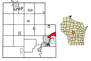
Spencer is a village in Marathon County, Wisconsin. It is part of the Wausau, Wisconsin Metropolitan Statistical Area. The population was 1,925 at the 2010 census.

<span class="mw-page-title-main">Montello, Wisconsin</span> City in Wisconsin, United States

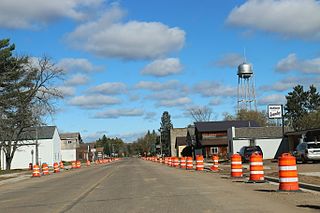
Montello is a city in and the county seat of Marquette County, Wisconsin, United States. The population was 1,495 at the 2010 census. The Fox River flows through the city. Montello is home to the largest tree in Wisconsin. A notable attraction in the city is the former granite quarry, which has been transformed into a park with several waterfalls.

<span class="mw-page-title-main">Oxford, Wisconsin</span> Village in Wisconsin, United States

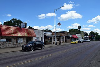
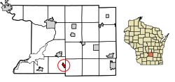
Oxford is a village in Marquette County, Wisconsin, United States. The population was 537 at the 2020 census. The village is located within the Town of Oxford. The Union Pacific Railroad runs through the town and over Neenah Lake to the northwest.

<span class="mw-page-title-main">Radisson, Wisconsin</span> Village in Wisconsin, United States

Radisson is a village in Sawyer County, Wisconsin, United States, along the Couderay River. The population was 241 at the 2010 census. The village is located within the Town of Radisson and was named in honor of the early French explorer, Pierre-Esprit Radisson (c.1636–1710).

<span class="mw-page-title-main">Iola, Wisconsin</span> Village in Wisconsin, United States

Iola is a village in Waupaca County, Wisconsin, United States. The population was 1,236 at the 2020 census. The village is bordered by the towns of Iola and Scandinavia. The community was named after a Potawatomi girl.

References

  1. (2022) League of Wisconsin Municipalities. Directory of Cities & Villages. Pg. 5 of 135.
  2. "2019 U.S. Gazetteer Files". United States Census Bureau. Retrieved August 7, 2020.
  3. 1 2 "US Board on Geographic Names". United States Geological Survey. October 25, 2007. Retrieved January 31, 2008.
  4. 1 2 "U.S. Census website". United States Census Bureau . Retrieved November 18, 2012.
  5. 1 2 "Population and Housing Unit Estimates". United States Census Bureau. May 24, 2020. Retrieved May 27, 2020.
  6. 1 2 "U.S. Census website". United States Census Bureau . Retrieved January 31, 2008.
  7. Gard, Robert (2015). The Romance of Wisconsin Place Names. Madison, WI: Wisconsin Historical Society Press. p. 12. ISBN   978-0-87020-707-5.
  8. "US Gazetteer files: 2010, 2000, and 1990". United States Census Bureau. February 12, 2011. Retrieved April 23, 2011.
  9. "US Gazetteer files 2010". United States Census Bureau. Archived from the original on January 25, 2012. Retrieved November 18, 2012.
  10. 1 2 "NOAA Online Weather Data – NWS Milwaukee". National Weather Service. Retrieved May 3, 2023.
  11. "U.S. Climate Normals Quick Access – Station: Arlington, WI". National Oceanic and Atmospheric Administration. Retrieved May 3, 2023.
  12. "Census of Population and Housing". Census.gov. Retrieved June 4, 2015.