Doylestown, Wisconsin

Last updated

Doylestown, Wisconsin
Doylestown Wisconsin Municipal Building.jpg
Doylestown Municipal Building
Columbia County Wisconsin Incorporated and Unincorporated areas Doylestown Highlighted.svg
Location of Doylestown in Columbia County, Wisconsin.
Coordinates: 43°25′40″N89°8′57″W / 43.42778°N 89.14917°W / 43.42778; -89.14917
Country Flag of the United States.svg  United States
State Flag of Wisconsin.svg  Wisconsin
County Columbia
Area
[1]
  Total4.00 sq mi (10.36 km2)
  Land3.89 sq mi (10.07 km2)
  Water0.11 sq mi (0.29 km2)
Elevation
[2]
945 ft (288 m)
Population
 (2010) [3]
  Total297
  Estimate 
(2019) [4]
297
  Density76.41/sq mi (29.50/km2)
Time zone UTC-6 (Central (CST))
  Summer (DST) UTC-5 (CDT)
FIPS code 55-20775 [5]
GNIS feature ID1564096 [2]

Doylestown is a village in Columbia County, Wisconsin, United States. The population was 297 at the 2010 census. It is part of the Madison Metropolitan Statistical Area.

Contents

Geography

According to the United States Census Bureau, the village has a total area of 4.02 square miles (10.41 km2), of which, 3.90 square miles (10.10 km2) of it is land and 0.12 square miles (0.31 km2) is water. [6]

Demographics

Historical population
CensusPop.Note
1870 100
1880 11919.0%
1910 259
1920 2704.2%
1930 238−11.9%
1940 2536.3%
1950 2613.2%
1960 249−4.6%
1970 2656.4%
1980 29410.9%
1990 3167.5%
2000 3283.8%
2010 297−9.5%
2019 (est.)297 [4] 0.0%
U.S. Decennial Census [7]

2010 census

As of the census [3] of 2010, there were 297 people, 116 households, and 85 families living in the village. The population density was 76.2 inhabitants per square mile (29.4/km2). There were 123 housing units at an average density of 31.5 per square mile (12.2/km2). The racial makeup of the village was 97.6% White, 0.3% Native American, 1.3% from other races, and 0.7% from two or more races. Hispanic or Latino of any race were 2.0% of the population.

There were 116 households, of which 32.8% had children under the age of 18 living with them, 54.3% were married couples living together, 13.8% had a female householder with no husband present, 5.2% had a male householder with no wife present, and 26.7% were non-families. 18.1% of all households were made up of individuals, and 7.7% had someone living alone who was 65 years of age or older. The average household size was 2.56 and the average family size was 2.93.

The median age in the village was 43.3 years. 20.9% of residents were under the age of 18; 7.1% were between the ages of 18 and 24; 25.6% were from 25 to 44; 32.3% were from 45 to 64; and 14.1% were 65 years of age or older. The gender makeup of the village was 52.2% male and 47.8% female.

2000 census

As of the census [5] of 2000, there were 328 people, 121 households, and 84 families living in the village. The population density was 83.4 people per square mile (32.2/km2). There were 123 housing units at an average density of 31.3 per square mile (12.1/km2). The racial makeup of the village was 99.09% White, 0.61% African American, and 0.30% from two or more races. Hispanic or Latino of any race were 4.27% of the population.

There were 121 households, out of which 40.5% had children under the age of 18 living with them, 54.5% were married couples living together, 8.3% had a female householder with no husband present, and 29.8% were non-families. 20.7% of all households were made up of individuals, and 9.1% had someone living alone who was 65 years of age or older. The average household size was 2.71 and the average family size was 3.15.

In the village, the population was spread out, with 31.1% under the age of 18, 5.2% from 18 to 24, 36.3% from 25 to 44, 13.4% from 45 to 64, and 14.0% who were 65 years of age or older. The median age was 34 years. For every 100 females, there were 97.6 males. For every 100 females age 18 and over, there were 91.5 males.

The median income for a household in the village was $53,125, and the median income for a family was $56,563. Males had a median income of $36,250 versus $26,429 for females. The per capita income for the village was $19,157. None of the families and 2.4% of the population were living below the poverty line, including no under eighteens and 5.0% of those over 64.

Government

Doylestown Village Hall Doylestown Municipal Building Up Close.jpg
Doylestown Village Hall

Doylestown is administered by a Village Board, Board President, and Village Clerk. The Municipal Building houses the Village Board, Village Clerk, and Fire Department.

The village and surrounding area are served by the Doylestown Fire Department.

The village has a United States Post Office with a zip code of 53928. [8]

Doylestown Post Office Doylestown Wisconsin Post Office.jpg
Doylestown Post Office

Politics

Doylestown village vote
by party in presidential elections
Year Democratic Republican Third Parties
2016 [9] 45.32%6343.88% 6110.79% 15
2012 [10] 63.38%9034.51% 492.11% 3
2008 [11] 50.66%7746.05% 703.29% 5
2004 [12] 44.59% 6655.41%82

Notable people

Related Research Articles

<span class="mw-page-title-main">Otsego, Wisconsin</span> Town in Wisconsin, United States

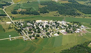
The Town of Otsego is located in Columbia County, Wisconsin, United States. The population was 757 at the 2000 census. The unincorporated community of Otsego is located in the town. The villages of Rio and Doylestown lie in the geographic area of the town of Otsego.

<span class="mw-page-title-main">Blue River, Wisconsin</span> Village in Wisconsin, United States

Blue River is a village in Grant County, Wisconsin, United States. The population was 434 at the 2010 census.

<span class="mw-page-title-main">Monticello, Green County, Wisconsin</span> Village in Wisconsin, United States

Monticello is a village in Green County, Wisconsin, United States. The population was 1,217 as of the 2010 census.

<span class="mw-page-title-main">Hollandale, Wisconsin</span> Village in Wisconsin, United States

Hollandale is a village in Iowa County, Wisconsin, United States. The population was 306 at the 2020 census. It is part of the Madison Metropolitan Statistical Area.

<span class="mw-page-title-main">Coleman, Wisconsin</span> Village in Wisconsin, United States

Coleman is a village in Marinette County, Wisconsin, United States. The population was 726 at the 2020 census. It is part of the Marinette, WI–MI Micropolitan Statistical Area.

<span class="mw-page-title-main">Weyerhaeuser, Wisconsin</span> Village in Wisconsin, United States

Weyerhaeuser is a village in Rusk County, Wisconsin, United States. The population was 238 at the 2010 census.

<span class="mw-page-title-main">Pigeon Falls, Wisconsin</span> Village in Wisconsin, United States

Pigeon Falls is a village in Trempealeau County, Wisconsin, United States. The population was 411 at the 2010 census.

<span class="mw-page-title-main">Big Falls, Waupaca County, Wisconsin</span> Village in Wisconsin, United States

Big Falls is a village in Waupaca County, Wisconsin, United States. The population was 61 at the 2010 census.

<span class="mw-page-title-main">Dorchester, Wisconsin</span> Village in Wisconsin, United States

Dorchester is a village in Clark and Marathon counties in the U.S. state of Wisconsin, along the 45th parallel. It is part of the Wausau, Wisconsin Metropolitan Statistical Area. The population was 876 at the 2010 census. Of this, 871 were in Clark County, and only 5 were in Marathon County.

<span class="mw-page-title-main">Viola, Wisconsin</span> Village in Wisconsin, United States

Viola is a village in Richland (mostly) and Vernon counties in the U.S. state of Wisconsin. The population was 699 at the 2010 census. Of this, 477 were in Richland County, and 222 were in Vernon County.

<span class="mw-page-title-main">Unity, Wisconsin</span> Village in Wisconsin, United States

Unity is a village in Clark and Marathon counties in the U.S. state of Wisconsin. It is part of the Wausau, Wisconsin Metropolitan Statistical Area. The population was 343 at the 2010 census. Of this, 204 were in Marathon County, and 139 were in Clark County. The village is located in northeastern town of Unity in Clark County and northwestern town of Brighton in Marathon County.

<span class="mw-page-title-main">Randolph, Wisconsin</span> Village in Wisconsin, United States

Randolph is a village in Columbia and Dodge Counties in the U.S. state of Wisconsin. The population was 1,811 at the 2010 census. Of this, 1,339 were in Dodge County, and 472 were in Columbia County. The village is located at the southeast corner of the Town of Randolph in Columbia County, although only a tiny portion of the village lies within the town. Most of the village lies within the Town of Westford in Dodge County. Small portions also lie within the Town of Fox Lake to the north and the Town of Courtland in Columbia County.

<span class="mw-page-title-main">Wyocena, Wisconsin</span> Village in Wisconsin, United States

Wyocena is a village in Columbia County, Wisconsin, United States. The population was 768 at the 2010 census. The village is located within the Town of Wyocena. It is part of the Madison Metropolitan Statistical Area.

<span class="mw-page-title-main">Lowell, Wisconsin</span> Village in Wisconsin, United States

Lowell is a village in Dodge County, Wisconsin, United States, along the Beaver Dam River. The population was 340 at the 2010 census. The village is located within the Town of Lowell.

<span class="mw-page-title-main">Eden, Wisconsin</span> Village in Wisconsin, United States

Eden is a village in Fond du Lac County, Wisconsin, United States. The population was 875 at the 2010 census. The village is located within the Town of Eden.

<span class="mw-page-title-main">Melrose, Wisconsin</span> Village in Wisconsin, United States

Melrose is a village in Jackson County, Wisconsin, United States. The population was 503 at the 2010 census. The village is located within the Town of Melrose.

<span class="mw-page-title-main">Necedah, Wisconsin</span> Village in Wisconsin, United States

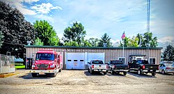
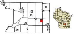
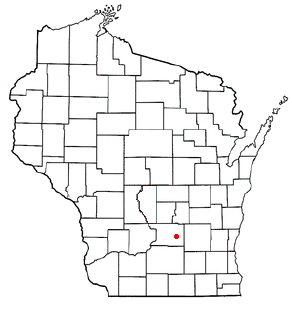
Necedah is a village in Juneau County, Wisconsin, United States. The population was 916 at the 2020 census. The village is located within the Town of Necedah.

<span class="mw-page-title-main">Milltown, Wisconsin</span> Village in Wisconsin, United States

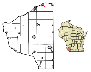
Milltown is a village in Polk County, Wisconsin, United States. The population was 917 at the 2010 census. The village is located within the Town of Milltown.

<span class="mw-page-title-main">Aniwa, Wisconsin</span> Village in Wisconsin, United States

Aniwa is a village in Shawano County, Wisconsin, United States. The population was 260 at the 2010 census. The village is located within the Town of Aniwa. U.S. Route 45 runs north–south through the village.

<span class="mw-page-title-main">Scandinavia, Wisconsin</span> Village in Wisconsin, United States

Scandinavia is a village in the Town of Scandinavia in Waupaca County, Wisconsin, United States. The population was 328 at the 2010 census.

References

  1. "2019 U.S. Gazetteer Files". United States Census Bureau. Retrieved August 7, 2020.
  2. 1 2 "US Board on Geographic Names". United States Geological Survey. October 25, 2007. Retrieved January 31, 2008.
  3. 1 2 "U.S. Census website". United States Census Bureau . Retrieved November 18, 2012.
  4. 1 2 "Population and Housing Unit Estimates". United States Census Bureau. May 24, 2020. Retrieved May 27, 2020.
  5. 1 2 "U.S. Census website". United States Census Bureau . Retrieved January 31, 2008.
  6. "US Gazetteer files 2010". United States Census Bureau. Archived from the original on July 2, 2012. Retrieved November 18, 2012.
  7. "Census of Population and Housing". Census.gov. Retrieved June 4, 2015.
  8. "Post Office in Doylestown, WI - Hours and Location".
  9. "November 8, 2016 General Election".
  10. "November 6, 2012 Partisan Office Election".
  11. "PRECINCT REPORT NOVEMBER 4, 2008 UNOFFICIAL RESULTS". www.co.columbia.wi.us. November 10, 2008. Retrieved January 23, 2023.
  12. "The State: State of Wisconsin 2005-2006 Blue Book: Elections".
  13. 'Wisconsin Blue Book 1937,' Biographical Sketch of Robert H. Doyle, pg. 40