Poynette, Wisconsin | |
---|---|
Coordinates: 43°23′32″N89°24′3″W / 43.39222°N 89.40083°W | |
Country | United States |
State | Wisconsin |
County | Columbia |
Government | |
Area | |
• Total | 2.59 sq mi (6.72 km2) |
• Land | 2.57 sq mi (6.65 km2) |
• Water | 0.03 sq mi (0.06 km2) |
Elevation | 840 ft (256 m) |
Population | |
• Total | 2,590 |
• Estimate (2019) [4] | 2,510 |
• Density | 977.41/sq mi (377.34/km2) |
• Demonym | Poynesian |
Time zone | UTC-6 (Central (CST)) |
• Summer (DST) | UTC-5 (CDT) |
Area code | 608 |
FIPS code | 55-64900 [5] |
GNIS feature ID | 1571865 [2] |
Website | www.poynette-wi.gov |
Poynette is a village in Columbia County, Wisconsin, United States. The population was 2,575 at the 2022 United States census. It is part of the Madison Metropolitan Statistical Area.
Poynette was named after Pierre Paquette (1796–1836), an early fur trader and settler of south central Wisconsin. When an application was made for a post office in the settlement, Paquette's name was misread as Poynette, and the post office was mistakenly named "Poynette". The village was then named after the post office. [6] [7] The community was incorporated in 1892. [8]
The Village of Poynette is located in Sections 34 and 35 of the Town of Dekorra (T 11 N, R 9 E), at 43°23′32″N89°24′3″W / 43.39222°N 89.40083°W (43.392, -89.401). [9]
According to the United States Census Bureau, the village has a total area of 2.58 square miles (6.68 km2), of which, 2.55 square miles (6.60 km2) of it is land and 0.03 square miles (0.08 km2) is water. [10]
Census | Pop. | Note | %± |
---|---|---|---|
1870 | 300 | — | |
1880 | 366 | 22.0% | |
1890 | 517 | 41.3% | |
1900 | 533 | 3.1% | |
1910 | 656 | 23.1% | |
1920 | 724 | 10.4% | |
1930 | 672 | −7.2% | |
1940 | 870 | 29.5% | |
1950 | 969 | 11.4% | |
1960 | 1,090 | 12.5% | |
1970 | 1,118 | 2.6% | |
1980 | 1,447 | 29.4% | |
1990 | 1,662 | 14.9% | |
2000 | 2,266 | 36.3% | |
2010 | 2,528 | 11.6% | |
2020 | 2,590 | 2.5% | |
U.S. Decennial Census [11] |
As of the census [3] of 2010, there were 2,528 people, 1,046 households, and 670 families living in the village. The population density was 991.4 inhabitants per square mile (382.8/km2). There were 1,122 housing units at an average density of 440.0 per square mile (169.9/km2). The racial makeup of the village was 96.6% White, 0.9% African American, 0.8% Native American, 0.3% Asian, 0.1% from other races, and 1.2% from two or more races. Hispanic or Latino of any race were 1.6% of the population.
There were 1,046 households, of which 35.9% had children under the age of 18 living with them, 47.9% were married couples living together, 11.6% had a female householder with no husband present, 4.6% had a male householder with no wife present, and 35.9% were non-families. 30.6% of all households were made up of individuals, and 12.7% had someone living alone who was 65 years of age or older. The average household size was 2.41 and the average family size was 3.01.
The median age in the village was 36.8 years. 26.8% of residents were under the age of 18; 7.2% were between the ages of 18 and 24; 29.2% were from 25 to 44; 26% were from 45 to 64; and 10.8% were 65 years of age or older. The gender makeup of the village was 49.3% male and 50.7% female.
As of the census [5] of 2000, there were 2,266 people, 919 households, and 578 families living in the village. The population density was 939.3 people per square mile (363.0/km2). There were 957 housing units at an average density of 396.7 per square mile (153.3/km2). The racial makeup of the village was 97.35% White, 0.22% African American, 0.53% Native American, 0.09% Asian, 0.71% from other races, and 1.10% from two or more races. Hispanic or Latino of any race were 1.46% of the population.
There were 919 households, out of which 35.8% had children under the age of 18 living with them, 48.3% were married couples living together, 9.2% had a female householder with no husband present, and 37.0% were non-families. 30.5% of all households were made up of individuals, and 13.9% had someone living alone who was 65 years of age or older. The average household size was 2.46 and the average family size was 3.04.
In the village, the population was spread out, with 28.4% under the age of 18, 7.1% from 18 to 24, 34.0% from 25 to 44, 18.9% from 45 to 64, and 11.5% who were 65 years of age or older. The median age was 34 years. For every 100 females, there were 103.6 males. For every 100 females age 18 and over, there were 99.8 males.
The median income for a household in the village was $45,000, and the median income for a family was $53,804. Males had a median income of $35,813 versus $25,098 for females. The per capita income for the village was $18,962. About 3.1% of families and 6.0% of the population were below the poverty line, including 5.7% of those under age 18 and 11.5% of those age 65 or over.
Poynette is served by the Poynette School District, which includes Poynette High School, Poynette Middle School and Arlington Elementary Schools.
Lakehead-Lakeshore is an unincorporated community and a former census-designated place (CDP) in Shasta County, California, United States. The population was 549 at the 2000 census. It is a very seasonal town with many Shasta Lake services, including a small grocery store and low-cost lodging for Shasta Lake visitors. It also has several campgrounds.
Friendship is a village in Adams County in the U.S. state of Wisconsin. It is the county seat of Adams County. The population was 725 at the 2010 census.
Sherwood is a village in Calumet County, Wisconsin, United States. The population was 2,713 at the 2010 census. The former historical unincorporated community of High Cliff is located within present-day Sherwood.
Dekorra is a town in Columbia County, Wisconsin, United States. The population was 2,350 at the 2000 census.
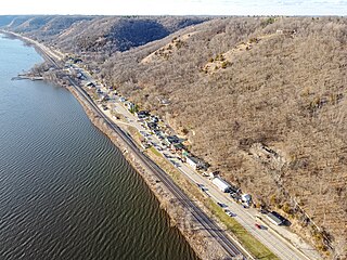
Ferryville is a village in Crawford County, Wisconsin, United States. The population was 176 at the 2010 census. It is located on Wisconsin Highway 35 along the Great River Road.
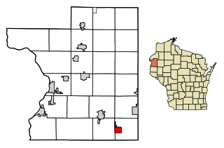
Oliver is a village in Douglas County, Wisconsin, United States. The population was 423 at the 2020 census.
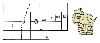
Fall Creek is a village in Eau Claire County, Wisconsin, United States. The population was 1,315 at the 2010 census. The village is bordered by the Town of Lincoln.
Cleveland is a village in Manitowoc County, Wisconsin, United States. The population was 1,579 at the 2020 census.
Stratford is a village in Marathon County, Wisconsin, United States. It is part of the Wausau, Wisconsin Metropolitan Statistical Area. The population was 1,578 at the 2010 census.
Yuba is a village in Richland County, Wisconsin, United States. The population was 74 at the 2010 census. Yuba is 11 miles southwest of Hillsboro and 17 miles north of Richland Center. County Hwy C runs through the village.
Ingram is a village in Rusk County, Wisconsin, United States. The population was 78 at the 2010 census.
Pigeon Falls is a village in Trempealeau County, Wisconsin, United States. The population was 411 at the 2010 census.
Dallas is a village in Barron County in the U.S. state of Wisconsin. The population was 409 at the 2010 census. The village is located within the Town of Dallas.
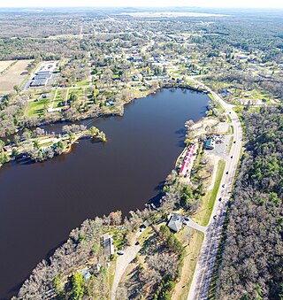
Wyocena is a village in Columbia County, Wisconsin, United States. The population was 768 at the 2010 census. The village is located within the Town of Wyocena. It is part of the Madison Metropolitan Statistical Area.
Eastman is a village in Crawford County, Wisconsin, United States. The population was 428 at the 2010 census. The village is located within the Town of Eastman.
Hixton is a village in Jackson County, Wisconsin, United States, along the Trempealeau River. The population was 433 at the 2010 census. The village is located within the Town of Hixton.
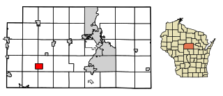
Wonewoc is a town in Juneau County, Wisconsin, United States. The population was 783 at the 2000 census. The Village of Wonewoc and the village of Union Center are located within the town.
Clear Lake is a village in Polk County, Wisconsin, United States. The population was 1,099 at the 2020 census. The village is adjacent to the Town of Clear Lake along U.S. Highway 63.
Coloma is a village in Waushara County, Wisconsin, United States. The population was 450 at the 2010 census. The village is located within the Town of Coloma. Coloma is home of the annual Coloma Chicken Chew, held at the end of June.
Plainfield is a village in Waushara County, Wisconsin, United States. The village is located almost entirely within the Town of Plainfield. A tiny portion extends into adjacent Town of Oasis. The population was 897 at the 2010 census.