Gerardus Mercator was a Flemish geographer, cosmographer and cartographer. He is most renowned for creating the 1569 world map based on a new projection which represented sailing courses of constant bearing as straight lines—an innovation that is still employed in nautical charts.

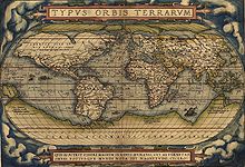
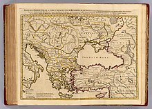
Abraham Ortelius was a cartographer, geographer, and cosmographer from Antwerp in the Spanish Netherlands. He is recognized as the creator of the first modern atlas, the Theatrum Orbis Terrarum. Along with Gemma Frisius and Gerardus Mercator, Ortelius is generally considered one of the founders of the Netherlandish school of cartography and geography. He was a notable figure of this school in its golden age and an important geographer of Spain during the age of discovery. The publication of his atlas in 1570 is often considered as the official beginning of the Golden Age of Netherlandish cartography. He was the first person proposing that the continents were joined before drifting to their present positions.

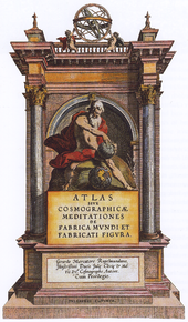
Theatrum Orbis Terrarum is considered to be the first true modern atlas. Written by Abraham Ortelius, strongly encouraged by Gillis Hooftman and originally printed on 20 May 1570 in Antwerp, it consisted of a collection of uniform map sheets and supporting text bound to form a book for which copper printing plates were specifically engraved. The Ortelius atlas is sometimes referred to as the summary of sixteenth-century cartography. The publication of the Theatrum Orbis Terrarum (1570) is often considered as the official beginning of the Golden Age of Netherlandish cartography.

Jodocus Hondius was a Flemish and Dutch engraver and cartographer. He is sometimes called Jodocus Hondius the Elder to distinguish him from his son Jodocus Hondius II. Hondius is best known for his early maps of the New World and Europe, for re-establishing the reputation of the work of Gerard Mercator, and for his portraits of Francis Drake. He inherited and republished the plates of Mercator, thus reviving his legacy, also making sure to include independent revisions to his work. One of the notable figures in the Golden Age of Dutch cartography, he helped establish Amsterdam as the center of cartography in Europe in the 17th century.

Gerard de Jode was a Netherlandish cartographer, engraver, and publisher who lived and worked in Antwerp.
Inventio Fortunata, "Fortunate, or fortune-making, discovery", is a lost book, probably dating from the 14th century, containing a description of the North Pole as a magnetic island surrounded by a giant whirlpool and four continents. No direct extracts from the document have been discovered, but its influence on the Western idea of the geography of the Arctic region persisted for several centuries.
The earliest known world maps date to classical antiquity, the oldest examples of the 6th to 5th centuries BCE still based on the flat Earth paradigm. World maps assuming a spherical Earth first appear in the Hellenistic period. The developments of Greek geography during this time, notably by Eratosthenes and Posidonius culminated in the Roman era, with Ptolemy's world map, which would remain authoritative throughout the Middle Ages. Since Ptolemy, knowledge of the approximate size of the Earth allowed cartographers to estimate the extent of their geographical knowledge, and to indicate parts of the planet known to exist but not yet explored as terra incognita.
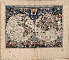
The Atlas Maior is the final version of Joan Blaeu's atlas, published in Amsterdam between 1662 and 1672, in Latin, French, Dutch, German and Spanish, containing 594 maps and around 3,000 pages of text. It was the largest and most expensive book published in the seventeenth century. Earlier, much smaller versions, titled Theatrum Orbis Terrarum, sive, Atlas Novus, were published from 1634 onwards. Like Abraham Ortelius's Theatrum Orbis Terrarum (1570), the Atlas Maior is widely considered a masterpiece of the Golden Age of Dutch/Netherlandish cartography.

A historical atlas is a collection of maps and possibly illustrations that depict the historical geography of a particular region at a defined time period. These atlases typically include maps that show the political and cultural boundaries of different states as well as other data, and in some cases illustrations that provide information about important historical events and figures. They may also include timelines, charts, and other information to help readers understand the historical context of the maps. Historical atlases are used by scholars, students, and general readers to study and learn about the past.
St Matthew Island is a phantom island once thought to lie roughly one thousand kilometers northeast of Ascension Island in the Atlantic Ocean. It appeared on navigational charts until as late as the early twentieth century. It was supposedly located at approximately 2°S 8°W, and was alleged to have been discovered by the Portuguese on St. Matthew's Day 1516. It was shown and named on several maps going back to the beginning of the sixteenth century, and it was supposedly visited by García Jofre de Loaísa on 20 October 1525 while on a voyage to the Moluccas. It appeared on early Portuguese charts and world maps, and appears on Ortelius' 1570 map of the African continent Africae Tabula Nova. It thereafter regularly featured on charts and maps, and though it began to disappear from standard charts starting in the early nineteenth century, it was not completely removed from charts until the early twentieth century.

Georg Braun was a German topo-geographer. From 1572 to 1617, he edited the Civitates orbis terrarum, which contains 546 prospects, bird's-eye views and maps of cities from all around the world. As principal editor of the work, he acquired the tables, hired the artists, and wrote the texts. He died as an octogenarian in 1622, the only survivor of the original team to witness the publication of volume VI in 1617.
Frans Hogenberg (1535–1590) was a Flemish and German painter, engraver, and mapmaker.

The Harmonia Macrocosmica is a star atlas written by Andreas Cellarius and published in 1660 by Johannes Janssonius. The first part of the atlas contains copper plate prints depicting the world systems of Claudius Ptolemy, Nicolaus Copernicus, and Tycho Brahe. At the end are star maps of the classical and further constellations, the latter ones as introduced by Julius Schiller in his Coelum stellatum christianum of 1627.

Cambriae Typus, the "model image of Wales", is the earliest published map of Wales as a separate country from the rest of Great Britain. Made by Elizabethan polymath Humphrey Llwyd in 1573, the map shows Wales stretching to the River Severn, including large areas of what is now England.

Pietro Coppo was an Italian geographer and cartographer who wrote a description of the entire world as known in the 16th century, accompanied by a set of systematically arranged maps, one of the first rutters and also a precise description of the Istrian Peninsula, accompanied by its first regional map.

Marcel Peter René van den Broecke was a Dutch specialist in phonetics and also in cartography, more in particular the historical maps by Abraham Ortelius.

Africae Tabula Nova is a map of Africa published by Abraham Ortelius in 1570. It was engraved by Frans Hogenberg and included in Ortelius's 1570 atlas Theatrum Orbis Terrarum, commonly regarded as the first modern atlas. The atlas was printed widely in seven languages and 31 total editions between 1570 and 1612.
Jean Surhon, also known as Jean de Surhon, Jean Surhonio, Jean Surchon, Johann Surhonio or Ioannes Suthon, was a Franco-Flemish engraver and cartographer.