
Chesil Beach in Dorset, England is one of three major shingle beach structures in Britain. Its name is derived from the Old English ceosel or cisel, meaning "gravel" or "shingle". It runs for a length of 29 kilometres (18 mi) from West Bay to the Isle of Portland and in places is up to 15 metres (50 ft) high and 200 metres (660 ft) wide. Behind the beach is the Fleet, a shallow tidal lagoon. Both are part of the Jurassic Coast and a UNESCO World Heritage Site, and together form an SSSI and Ramsar Site.

Portland Harbour is located beside the Isle of Portland, Dorset, on the south coast of England. Construction of the harbour began in 1849; when completed in 1872, its 520-hectare (1,300-acre) surface area made it the largest human-made harbour in the world, and it remains one of the largest in the world today. It is naturally sheltered by Portland to the south, Chesil Beach to the west and mainland Dorset to the north. It consists of four breakwaters: two southern and two northern. These have a total length of 4.57 km (2.84 mi) and enclose approximately 1,000 ha of water.
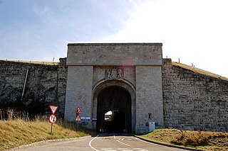
Verne Citadel is a 19th-century citadel on the Isle of Portland, Dorset, England. Located on the highest point of Portland, Verne Hill, it sits in a commanding position overlooking Portland Harbour, which it was built to defend. It later became HM Prison The Verne in 1949.

Wakeham is a hamlet near the village of Easton, in Tophill on the Isle of Portland in Dorset, England. It is situated between the Straits part of Easton, and Pennsylvania Castle. As with the rest of Portland's villages and settlements, Wakeham has been designated as a conservation area, as it is a place of special architectural and historic interest. Easton, Wakeham and Reforne were designated pre-1974. The hamlet features a distinctively wide road running through it, once built to allow space for horse-drawn carts transporting stone by road. Many of Wakeham's older buildings of the 17th and 18th century survive.

Castletown is a small village in Underhill on the Isle of Portland in Dorset. It is located close to Fortuneswell, on the shores of Portland Harbour, and includes a sandy beach, as well as one of Portland's notable highlights; Portland Castle, while the Weymouth and Portland National Sailing Academy is also located nearby.

Southwell is a small coastal village in Tophill on the Isle of Portland, Dorset. As Portland and Dorset's southernmost village, it lies between Portland Bill and the villages of Easton and Weston. Though close to the Bill, the village is sheltered by hills on three sides. It is the only village on Portland not to be designated a conservation area.

Church Ope Cove is a small secluded beach on the sheltered eastern side of the Isle of Portland in Dorset, southern England, and is part of the Jurassic Coast. It is found close to the village of Wakeham. The beach has many unusual features for the Isle of Portland. The beach used to be sandy, but quarry debris now covers the sand, and has been worn into rounded pebbles. The pebbles cover a small stream which runs to the sea, which is one of the few active streams remaining on the Isle of Portland.

White Nothe is a chalk headland on the English Channel coast at the eastern end of Ringstead Bay, east of Weymouth in Dorset, England. The area is well known for its geology and fossils. Its flanks are the result of prehistoric landslides and the inaccessible slopes of the undercliff provide a secluded wildlife habitat.
Bincleaves Groyne is a breakwater located off the southern area of Weymouth, England. It is the second largest of four breakwaters which create Portland Harbour. It is separated from the Northeastern Breakwater by the North Ship Channel. A landing stage is situated on the southern side of the breakwater near the Western Ledges.

Nothe Gardens is a public garden, located in Weymouth, Dorset, England. Positioned on the Nothe Peninsula overlooking both Weymouth and Portland harbours, the informal gardens are often acclaimed to be the most beautiful the borough has to offer.

Durdle Pier is a disused 17th-century stone shipping quay, located on the Isle of Portland, Dorset, England; part of the Jurassic Coast. It is found close by Yeolands Quarry, on the east side of the island within the area of East Weares and Penn's Weare.

Mutton Cove is a cove, located on the Isle of Portland, Dorset, England; part of the Jurassic Coast. It is found on the west side of Portland. Presumably named after the once-famous Portland sheep, the cove is an erosional indentation just south of the promontory of Blacknor. On the cliff tops of the cove is part of the South West Coast Path and further south is Wallsend Cove and Portland Bill.

Ferry Bridge is at the beginning of the causeway to the Isle of Portland, Dorset, England, and is the point at which the Fleet lagoon joins Portland Harbour. It is situated several hundred metres south of Portland's boundary with the village of Wyke Regis, Weymouth. To the west of Ferry Bridge is the start of The Fleet, which is an internationally important nature reserve that extends to Abbotsbury Swannery, while to the east is Portland Harbour. Along the harbour side is Smallmouth Beach. The only road between Portland and the Mainland passes across Ferry Bridge.
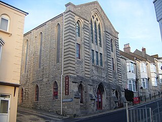
Royal Manor Theatre is a theatre located in Fortuneswell, Isle of Portland, Dorset, England. Formerly a Methodist chapel, the building was later converted into the Royal Manor Theatre, which opened in 1978.

Folly Pier is a disused stone shipping quay, located on the Isle of Portland, Dorset, England; part of the Jurassic Coast. It is found on the east side of the island within the area of East Weares. Other piers within the area include King's Pier and Durdle Pier respectively. Folly Pier dates from the 17th century.

East Weare Rifle Range is a disused naval rifle range on the Isle of Portland, Dorset, England. It is located within the area of East Weares, overlooking Portland Harbour. The range became a scheduled monument in October 2015, which included the stop butt of Portland stone, the marker's gallery and 100-yard firing position. It remains on the private property of Portland Port Ltd, and has not been opened to the public, however can be seen from surrounding coastal paths.

Merchant's Railway was a horse drawn and cable operated incline railway on the Isle of Portland, Dorset, England, built for the stone trade on the island. It was the earliest railway in Dorset, opening in 1826. The railway ran two miles from many working quarries at the north of Tophill, along the edge of Verne Hill, to a pier at Castletown, from where the Portland stone was shipped. It was in operation from 1826 to 1939. Since becoming disused the original path of the railway has become a popular public footpath.

Verne Heavy Anti-Aircraft Battery is a World War II anti-aircraft battery on the Isle of Portland, Dorset, England. It is located on private property in the north-east area of the island, south of the Verne Citadel. The battery became a scheduled monument in March 2019.

Inner Pierhead Fort is a 19th-century fort built to defend Portland Harbour at the Isle of Portland, Dorset, England. It is positioned on the end of the inner breakwater, which abuts from the former dockyard of HMNB Portland. The fort was constructed between 1859-1862, and is 100 ft in diameter. The inner breakwater, including the fort, became Grade II Listed in 1978.

Victoria Square is a public square on the Isle of Portland, Dorset, England. Developed in the 19th century, it is situated at the entrance to Portland, close to Chesil Beach, Osprey Quay, and the small fishing village of Chiswell.
