Lyme Bay

Last updated

Lyme Bay shown within Great Britain Lyme Bay.png
Lyme Bay shown within Great Britain

Lyme Bay is an area of the English Channel off the south coast of England. The south western counties of Devon and Dorset front onto the bay.

Contents

The exact definitions of the bay vary. The eastern boundary is usually taken to be Portland Bill on the Isle of Portland, but there is no consensus over the western boundary. The broadest definition places the boundary at Start Point, and therefore includes Tor Bay and Start Bay as areas within Lyme Bay. A narrow definition gives the eastern boundary as Hope's Nose headland, excluding Tor Bay and Start Bay, used for example by the Water Framework Directive definitions of waterbodies. [1] Other definitions place the boundary somewhere between these two points, including at Dartmouth (used by the Lyme Bay West Marine Character Area [2] ) and Berry Head. [3]

Geology

1954 Nautical vhart of Lyme Bay Admiralty Chart No 3315 Berry Head to Portland, Published 1954.jpg
1954 Nautical vhart of Lyme Bay
Golden Cap across Lyme Bay from Lyme Regis. 070329jad ukdor 01.jpg
Golden Cap across Lyme Bay from Lyme Regis.

The east of the bay is part of a World Heritage Site, the Dorset and East Devon Coast, [4] which is also known as the Jurassic Coast, named for its Jurassic geology.

History

Many of the earliest discoveries of dinosaur and other prehistoric reptile remains were in the area surrounding Lyme Regis and Charmouth. Notable among these were the discoveries made by self-educated palaeontologist and fossil collector Mary Anning, in the 1820s.

The weather in the bay is temperate by English standards, and far more temperate than many other places at a similar latitude. The reason for this is the warming action of the Gulf Stream. The area along the coast of Lyme Bay is thus a popular holiday destination. On 22 March 1993, four schoolchildren died in what is known as the Lyme Bay kayaking tragedy. [5]

Lyme Bay was the site of Exercise Tiger, [6] a practice run for the D-Day invasion of France in 1944, using the beach called Slapton Sands near Slapton, Devon as the practice landing zone. The operation was intercepted by German E-boats that attacked the landing craft, killing 749 American Army and Navy personnel in the middle of Babbacombe Bay, the most unbounded western sub-bay of the bay.

A ship commissioned in 2007 for the Royal Fleet Auxiliary carries the name: RFA Lyme Bay. [7]

Underwater

Much of the subsurface realm is locally unspectacular, without underwater rock cliffs painted with a riot of colour nor very clear water. [8]   The reefs in Lyme bay are mostly low lying and the waters tend to be fairly gloomy and turbid.  As an essentially large, open, sandy bay exposed to the prevailing winds, much suspended sediment (at least near-shore, close to the seabed) exists. [8]   Whilst winds may ease in summer, it is also prone to strong plankton blooms during May and June, with a less pronounced bloom in late summer.  Thus underwater visibility rarely exceeds 10 metres (30 ft) and frequently may be less than 3 metres (10 ft). [8]   The reefs in the bay, numerous in the centre and east, are mostly discontinuous, forming a patchwork of low rocky outcrops surrounded by sediment. [8]   This means that they tend to be covered by thin veneers of sediment as tide and wave action lifts and sweeps saltating sand across them.  The amount of sand will vary, depending on the size of the reef, how high it rises above the surrounding sediment plain, the strength of tidal streams in that part of the bay and how strong the wind has been recently (and thus how big the waves). Conversely the reef ecosystems are different from clearer water reefs further west. [8]

Wildlife

Tank wrecks from the D-Day practice provide a venue for diving. Marine life includes the Devon cup coral ( Caryophyllia smithii ) [9] and pink sea fan ( Eunicella verrucosa ) . [10] The pink seafan is a nationally protected species that occurs in very high densities on some of the limestone reefs in Lyme Bay. [11] Reefs in the Eastern part of Lyme Bay support a population of sunset corals (Leptopsammia pruvoti). Sunset corals are one of the very few species of true corals (i.e. stony, or scleractinian, corals found in British waters. Sunset corals are rare in British waters, known to occur at only a handful of locations. The Lyme Bay supports one of the densest populations found around the UK and also the easternmost population known in UK waters. [11]

The reefs have been under threat from scallop dredging which, if unregulated, might destroy the coral's habitat. Devon Wildlife Trust has been campaigning to protect the reefs, calling for an end to the dredging and trawling within a 60-square-mile (160 km2) zone to help the reefs recover. About 20% of this area is now protected by a voluntary agreement made between the DEFRA and the fishermen of the South West Inshore Fishermen's Association. [12]

Settlements

Golden Cap and East Devon from Burton Bradstock. Dorset lymebay 01.jpg
Golden Cap and East Devon from Burton Bradstock.

Towns and villages marked * fall outside some of the narrower definitions of Lyme Bay.

Rivers

Rivers that flow into Lyme Bay include the Exe, Otter, Teign, Dart, Sid and Axe in Devon, and the Lim, Char, Brit and Bride in Dorset. [13]

Shipping and sea conditions forecast

The whole bay forms the northwest of Portland in the UK's shipping forecast.

Related Research Articles

<span class="mw-page-title-main">Lyme Regis</span> Coastal town in Dorset, England

Lyme Regis is a town in west Dorset, England, 25 miles (40 km) west of Dorchester and east of Exeter. Sometimes dubbed the "Pearl of Dorset", it lies by the English Channel at the Dorset–Devon border. It has noted fossils in cliffs and beaches on the Jurassic Coast, a World Heritage Site and heritage coast. The harbour wall, known as The Cobb, appears in Jane Austen's novel Persuasion, the John Fowles novel The French Lieutenant's Woman and the 1981 film of that name, partly shot in the town.

<span class="mw-page-title-main">Jurassic Coast</span> World Heritage Site on the coast of southern England

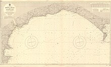
The Jurassic Coast is a World Heritage Site on the English Channel coast of southern England. It stretches from Exmouth in East Devon to Studland Bay in Dorset, a distance of about 96 miles (154 km), and was inscribed on the World Heritage List in mid-December 2001.

<span class="mw-page-title-main">South West Coast Path</span> Long-distance footpath in England

<span class="mw-page-title-main">Charmouth</span> Human settlement in England

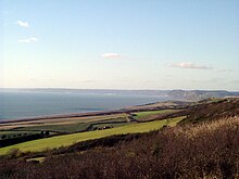
Charmouth is a village and civil parish in west Dorset, England. The village is situated on the mouth of the River Char, around 1+12 miles (2 km) north-east of Lyme Regis. Dorset County Council estimated that in 2013 the population of the civil parish was 1,310. In the 2011 Census the population of the parish, combined with the small parish of Catherston Leweston to the north, was 1,352.

<span class="mw-page-title-main">Geology of Dorset</span>

Dorset is a county in South West England on the English Channel coast. Covering an area of 2,653 square kilometres (1,024 sq mi); it borders Devon to the west, Somerset to the north-west, Wiltshire to the north-east, and Hampshire to the east. The great variation in its landscape owes much to the underlying geology, which includes an almost unbroken sequence of rocks from 200 to 40 million years ago (Mya) and superficial deposits from 2 Mya to the present. In general, the oldest rocks appear in the far west of the county, with the most recent (Eocene) in the far east. Jurassic rocks also underlie the Blackmore Vale and comprise much of the coastal cliff in the west and south of the county; although younger Cretaceous rocks crown some of the highpoints in the west, they are mainly to be found in the centre and east of the county.

The Pink Pippos of Portland is a 2002 children's storybook written by Sandra Fretwell. The book was adapted for the stage by Sandra’s daughter, Sophie Fretwell in 2020, and performed at the Royal Manor Theatre, Fortuneswell in July 2021, before going on tour with an all-star cast of Dan Almond, Laura Urquhart, Ethan Skillman, Ian Neale, Dan Babei and Verity Jefferis from August to October 2022.

<span class="mw-page-title-main">Staghorn coral</span> Species of coral

The staghorn coral is a branching, stony coral with cylindrical branches ranging from a few centimetres to over two metres in length and height. It occurs in back reef and fore reef environments from 0 to 30 m depth. Wave forces dictate the upper threshold, while suspended sediments and the availability of light regulate the lower boundary. Until the mid-1980s, the intermediate depths of 5–25 meters in the fore reef zones were once primarily occupied by vast areas of staghorn coral, consisting largely of single-species stands. This coral exhibits the fastest growth of all known western Atlantic fringe corals, with branches increasing in length by 10–20 cm (3.9–7.9 in) per year. This has been one of the three most important Caribbean corals in terms of its contribution to reef growth and fishery habitat.

<i>MSC Napoli</i> 1991–2007 UK-flagged container ship

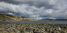
MSC Napoli was a United Kingdom-flagged container ship that developed a hull breach due to rough seas and slamming in the English Channel on 18 January 2007. She was deliberately run aground at Lyme Bay to avoid an environmental disaster and broken up by salvors.

<i>Eunicella verrucosa</i> Species of coral

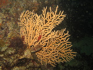
Eunicella verrucosa, the broad sea fan, pink sea fan or warty gorgonian, is a species of colonial Gorgonian "soft coral" in the family Gorgoniidae. It is native to the north-eastern Atlantic Ocean and the western Mediterranean Sea.

<span class="mw-page-title-main">Worbarrow Tout</span>

Worbarrow Tout is a promontory at the eastern end of Worbarrow Bay on Isle of Purbeck in Dorset on the south coast of England, about 6 kilometres (3.7 mi) south of Wareham and about 16 kilometres (10 mi) west of Swanage. Immediately to its east is Pondfield Cove.

<span class="mw-page-title-main">Dinosaurland Fossil Museum</span> Fossil museum in Dorset, England

Dinosaurland Fossil Museum is a privately owned fossil museum in Lyme Regis, on the Jurassic Coast in Dorset, England. The museum is located in a historic Grade I listed former congregational church building.

<span class="mw-page-title-main">Blacknor Fort</span>

Blacknor Fort is a 20th-century fort on the Isle of Portland, Dorset, England. It is located at Blacknor Point on the western side of Portland, close to Weston village.

<i>Pocillopora verrucosa</i> Species of coral

Pocillopora verrucosa, commonly known as cauliflower coral, rasp coral, or knob-horned coral, is a species of stony coral in the family Pocilloporidae. It is native to tropical and subtropical parts of the Indian and Pacific Oceans.

<i>Adna anglica</i> Genus of barnacles

Adna is a genus of acorn barnacles that grows in association with or semi-parasitically on corals and octocorals. Its only species is Adna anglica. It is found in the intertidal zone on the coasts of northwestern Europe and in the Mediterranean Sea.

The following index is provided as an overview of and topical guide to Wikipedia's articles on recreational dive sites. The level of coverage may vary:

<span class="mw-page-title-main">Dorset Council (UK)</span> Local authority in England

Dorset Council is a unitary local authority for the Dorset district in England covering most of the ceremonial county of Dorset. It was created on 1 April 2019 to administer most of the area formerly administered by Dorset County Council, which was previously subdivided into the districts of Weymouth and Portland, West Dorset, North Dorset, Purbeck, and East Dorset, as well as Christchurch, which is now part of Bournemouth, Christchurch and Poole.

<span class="mw-page-title-main">Outline of recreational dive sites</span> Hierarchical outline list of articles about rereational dive sites

Recreational dive sites are specific places that recreational scuba divers go to enjoy the underwater environment or for training purposes. They include technical diving sites beyond the range generally accepted for recreational diving. In this context all diving done for recreational purposes is included. Professional diving tends to be done where the job is, and with the exception of diver training and leading groups of recreational divers, does not generally occur at specific sites chosen for their easy access, pleasant conditions or interesting features.

<span class="mw-page-title-main">Blue Marine Foundation</span> Marine conservation organisation

Blue Marine Foundation is a marine conservation organisation. It was founded as a legacy project following the 2009 documentary film The End of the Line. It has been involved in establishing marine reserves in the Chagos Archipelago, Lyme Bay, and Turneffe Atoll.

References

  1. "Shoreline Management Plan Review (SMP2) : Durlston Head to Rame Head" (PDF). Southwest.coastalmonitoring.org. Retrieved 16 July 2022.
  2. "Seascape Assessment for the South Marine Plan Areas" (PDF). Assets.publishing.service.gov.uk. Retrieved 16 July 2022.
  3. "Lyme Bay Closed Area - Measuring Recovery of Benthic Species in cobble reef habitats" (PDF). Lymebayreserve.co.uk. Retrieved 16 July 2022.
  4. Nomination of the Dorset and East Devon Coast for Inclusion in the World Heritage List (Report). Dorset County Council. 2000.
  5. "The School Canoe Tragedy: Canoe instructors were not qualified". The Independent . 23 October 2011.
  6. Fenton, Ben (26 April 2004). "The disaster that could have scuppered Overlord". The Daily Telegraph . Retrieved 30 June 2016.
  7. "RFA LYME BAY (L3007) (Naval vessel)". FleetMon.com.
  8. 1 2 3 4 5 Munro, Colin. "Lyme Bay, what makes it special?". Colinmunrophotography.com. Retrieved 24 July 2020.
  9. "ARKive - Devonshire cup coral videos, photos and facts - Caryophyllia smithii". 11 October 2011. Archived from the original on 11 October 2011.
  10. "Pink sea fan - Eunicella verrucosa - ARKive". 8 December 2008. Archived from the original on 8 December 2008. Retrieved 16 July 2022.
  11. 1 2 Munro, Colin. "Lyme Bay Reefs". Marine-bio-images.com. Retrieved 24 July 2020.
  12. "Fishermen agree to limit Lyme Bay catches". The Guardian . 2 July 2012.
  13. "Rivers Lim & Axe". Wrt.org.uk. Retrieved 16 July 2022.

50°42′N2°54′W / 50.700°N 2.900°W / 50.700; -2.900