
Sidmouth is a town on the English Channel in Devon, South West England, 14 miles (23 km) southeast of Exeter. With a population of 12,569 in 2011, it is a tourist resort and a gateway to the Jurassic Coast World Heritage Site. A large part of the town has been designated a conservation area.
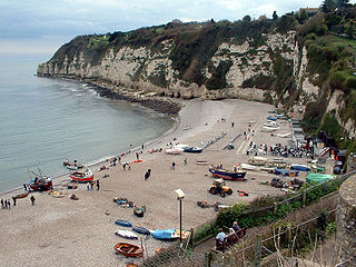
Beer is a village and civil parish in the East Devon district of Devon, England. The village faces Lyme Bay and is a little over 1 mile (1.6 km) west of the town of Seaton. It is situated on Jurassic Coast World Heritage Site and its picturesque cliffs, including Beer Head, form part of the South West Coast Path.

Combe Raleigh is a village and civil parish in the county of Devon, England. The village lies about 1.5 miles north of the town of Honiton, and the parish is surrounded, clockwise from the north, by the parishes of Luppitt, Honiton, Awliscombe and Dunkeswell.

Slapton is a village and civil parish in the South Hams district of Devon, England. It is located near the A379 road between Kingsbridge and Dartmouth, and lies within the South Devon Area of Outstanding Natural Beauty (AONB). The nearby beach is Slapton Sands.
Eype Mouth is a natural break in a line of sea cliffs on the Jurassic Coast World Heritage Site in west Dorset on the south coast of England. The small River Eype drains into the sea at this point. Eype means 'a steep place' in Old English. The village of Eype lies just upstream of the rivermouth, which is reached by a single narrow lane which runs down through Lower Eype to a shingle beach with car park.
All Saints is a civil parish in East Devon, Devon, England. It has a population of 498 according to the 2001 census. The parish includes the hamlets of All Saints, Smallridge, Churchill, Alston and Waggs Plot. This area also has one cricket pitch, a primary school, pre-school and a church.

Broadwoodkelly is a village and civil parish in the West Devon district of Devon, England. According to the 2001 census it had a population of 218. The village is situated about 9 miles (14 km) north of Okehampton.

Penstone is a hamlet of some 21 houses in Devon, England, about 1 mile (2 km) from the villages of Colebrooke and Coleford, close to the point where the Exeter-Barnstaple and former Exeter-Okehampton rail lines diverge; the latter is now a freight line but there has recently been talk of reopening it to passenger traffic and extending it to Plymouth in order to avoid the shoreline track at Dawlish Warren which has recently been washed away several times by winter storms. The nearest stations are Yeoford and Copplestone.
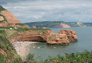
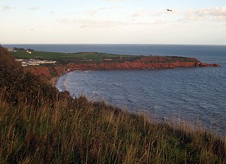
Ladram Bay is a secluded bay with a pebble beach, on the south coast of Devon, England between the coastal towns of Budleigh Salterton and Sidmouth. It is about 11 miles southeast of Exeter, just under 2 mi (3 km) southwest of Sidmouth and about 2+1⁄2 miles (4 km) northeast of Budleigh Salterton.

Vault Beach is situated on the south coast of Cornwall, England, UK, near Gorran Haven. The beach consists mainly of shingle but does have some sand at low tide. Vault Beach faces southeast onto the English Channel and lies between Cadythew Rocks in the north and Dodman Point at the southern end.

Pennsylvania is a suburb situated on the high ground to the north of the city of Exeter in the county of Devon, England. It lies between the ancient deer park of Duryard and Stoke Hill and was the last area of the city to be developed, because of its steep-sided valleys. It was named after the US state by Joseph Sparkes, a Quaker banker who built the first terrace, Pennsylvania Park, in about 1821.

Beacon is a hamlet near Honiton in the English county of Devon, below the most southerly point of Hartridge Hill in Luppitt parish.

Aller is a village in the civil parish of Kentisbeare in the historic county of Devon, England. Aller is situated about 2 miles (3.2 km) east of Cullompton.

Ash Thomas is a village in Devon, England.

Castle Dyke is an Iron Age hill fort situated between Chudleigh and Dawlish in Devon, England. The fort is situated on a Hilltop at approx 140 metres above sea level.
Goodleigh is a village about 1 km northeast of Bodmiscombe in the county of Devon, England.
There are eight settlements on the Isle of Portland, Dorset, England, the largest of which are Fortuneswell in Underhill and Easton on Tophill. The other villages of Weston, Southwell, Wakeham and the Grove also occupy Tophill, and Castletown and Chiswell are the other villages in Underhill.

Kennford is a village situated in the Teignbridge district of Devon, England. Kennford is four miles (6 km) to the south of Exeter in the civil parish of Kenn; it is situated in one of the country's main tourist areas.
Straight Point is a coastal region, forming a headland, between Exmouth and Budleigh Salterton in Devon on the south coast of England.

Strete is a village and civil parish in the South Hams district of Devon, England, on the coast of Start Bay, within the South Devon Area of Outstanding Natural Beauty.
