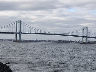
The Throgs Neck Bridge is a suspension bridge in New York City, carrying six lanes of Interstate 295 (I-295) over the East River where it meets the Long Island Sound. The bridge connects the Throggs Neck section of the Bronx with the Bay Terrace section of Queens.

The Atlantic City Expressway, officially numbered, but unsigned, as Route 446 and abbreviated A.C. Expressway, ACE, or ACX, and known locally as the Expressway, is a 44.19-mile (71.12 km) controlled-access toll road in the U.S. state of New Jersey, managed and operated by the South Jersey Transportation Authority (SJTA). It serves as an extension of the freeway part of Route 42 from Turnersville southeast to Atlantic City. The Atlantic City Expressway is signed as east-west, though the mileage and exits decrease as if one is travelling north-south. It connects Philadelphia and the surrounding Delaware Valley metropolitan area with Atlantic City and other Jersey Shore resorts, and also serves other South Jersey communities, including Hammonton and Mays Landing. The expressway intersects many major roads, including Route 73 in Winslow Township, Route 54 in Hammonton, Route 50 in Hamilton Township, the Garden State Parkway in Egg Harbor Township, U.S. Route 9 (US 9) in Pleasantville, and the Atlantic City–Brigantine Connector near the eastern terminus in Atlantic City.
E-ZPass is an electronic toll collection system used on toll roads, toll bridges, and toll tunnels in the Eastern United States, Midwestern United States, and Southern United States. The E-ZPass Interagency Group (IAG) consists of member agencies in several states, which use the same technology and allow travelers to use the same transponder on toll roads throughout the network.

The Inner Harbor is a historic seaport, tourist attraction, and landmark in Baltimore, Maryland. It was described by the Urban Land Institute in 2009 as "the model for post-industrial waterfront redevelopment around the world". The Inner Harbor is located at the mouth of Jones Falls, creating the wide and short northwest branch of the Patapsco River. The district includes any water west of a line drawn between the foot of President Street and the American Visionary Art Museum.

The Chesapeake Bay Bridge–Tunnel is a 17.6-mile (28.3 km) bridge–tunnel that crosses the mouth of the Chesapeake Bay between Delmarva and Hampton Roads in the U.S. state of Virginia. It opened in 1964, replacing ferries that had operated since the 1930s. A major project to dualize its bridges was completed in 1999, and in 2017 a similar project was started to dualize one of its tunnels.

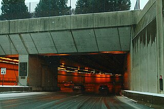
Interstate 895 (I-895) is an auxiliary Interstate Highway in the US state of Maryland. Known as the Harbor Tunnel Thruway, the highway runs 11.44 miles (18.41 km) between one junction with I-95 in Elkridge and another interchange with I-95 on the east side of Baltimore. I-895 is a toll road that crosses the Patapsco River estuary via the Baltimore Harbor Tunnel, connecting U.S. Route 1 (US 1), I-695, and the Baltimore–Washington Parkway in the southwestern suburbs of Baltimore with US 40 on the east side of Baltimore. In conjunction with a pair of spurs, unsigned I-895A and I-895B, I-895 provides access to the tunnel from I-97 and Maryland Route 2 (MD 2) in Glen Burnie. The highway is designed for through traffic by having partial interchanges that require vehicles from almost all starting points to pass through the tunnel and the tunnel toll plaza, where a $1.40-$6.00 toll is charged to passenger vehicles, before exiting the facility.

The Gov. William Preston Lane Jr. Memorial Bridge is a major dual-span bridge in the U.S. state of Maryland. Spanning the Chesapeake Bay, it connects the state's rural Eastern Shore region with its urban and suburban Western Shore, running between Stevensville and Sandy Point State Park near the capital city of Annapolis. The original span, opened in 1952 and with a length of 4 miles (6.4 km), was the world's longest continuous over-water steel structure. The parallel span was added in 1973. The bridge is named for William Preston Lane Jr., who as the 52nd Governor of Maryland launched its construction in the late 1940s after decades of political indecision and public controversy.

The Governor Harry W. Nice Memorial/Senator Thomas "Mac" Middleton Bridge, also known as the Potomac River Bridge, is a 1.7-mile (2.7 km), four-lane continuous truss bridge that spans the Potomac River between Newburg in Charles County, Maryland and Dahlgren in King George County, Virginia, United States. It is one of eight toll facilities operated by the Maryland Transportation Authority, and is one of two toll bridges over the Potomac River. The other, the privately owned Oldtown Low Water Toll Bridge, connects Maryland and West Virginia, far upstream. The new Nice Bridge opened to traffic in October 2022. Demolition of the original bridge began on March 21, 2023.
The Ted Williams Tunnel is a highway tunnel in Boston, Massachusetts. The third in the city to travel under Boston Harbor, with the Sumner Tunnel and the Callahan Tunnel, it carries the final segment of Interstate 90 from South Boston towards its eastern terminus at Route 1A in East Boston, slightly beyond Logan International Airport. The tunnel is named after the Boston Red Sox baseball legend Ted Williams.

Interstate 695 (I-695) is a 51.46-mile-long (82.82 km) auxiliary Interstate Highway that constitutes a beltway extending around Baltimore, Maryland, United States. I-695 is officially designated the McKeldin Beltway but is colloquially referred to as either the Baltimore Beltway or 695. The route is an auxiliary route of I-95, intersecting that route southwest of Baltimore near Arbutus and northeast of the city near White Marsh. It also intersects other major roads radiating from the Baltimore area, including I-97 near Glen Burnie, the Baltimore–Washington Parkway near Linthicum, I-70 near Woodlawn, I-795 near Pikesville, and I-83 in the Timonium area. The 19.37-mile (31.17 km) portion of the Baltimore Beltway between I-95 northeast of Baltimore and I-97 south of Baltimore is officially Maryland Route 695 (MD 695) and is not part of the Interstate Highway System but is signed as I-695. The Francis Scott Key Bridge that crossed over the Patapsco River was included in this section of the route before the bridge's collapse on March 26, 2024. The bridge and its approaches were maintained by the Maryland Transportation Authority (MDTA), while the remainder of the Baltimore Beltway is maintained by the Maryland State Highway Administration (MDSHA).

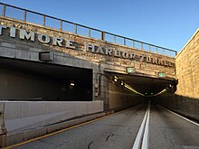
The Fort McHenry Tunnel is a four-tube, bi-directional tunnel that carries traffic on Interstate 95 (I-95) underneath the Baltimore Harbor. Named for nearby Fort McHenry, the tunnel is the lowest point in the Interstate Highway System under water.

The Thomas J. Hatem Memorial Bridge is a road bridge in northeast Maryland that crosses the Susquehanna River between Havre de Grace and Perryville via Garrett Island. It carries U.S. Route 40. It is the oldest of the eight toll facilities operated and maintained by the Maryland Transportation Authority, and the southernmost automotive bridge across the Susquehanna.
The Maryland Transportation Authority (MDTA) is an independent state agency responsible for financing, constructing, operating, and maintaining eight transportation facilities, currently consisting of two toll roads, two tunnels, and four bridges in Maryland. It also provides the Maryland Department of Transportation with financing for other revenue producing transportation projects.

The Francis Scott Key Bridge was a steel arch continuous through truss bridge that spanned the lower Patapsco River and outer Baltimore Harbor/Port in Maryland, United States. Opened on March 23, 1977, it carried the Baltimore Beltway between Dundalk in Baltimore County and Hawkins Point, an isolated southern neighborhood of Baltimore, while briefly passing through Anne Arundel County. The main spans and part of the northeastern approach of the bridge collapsed on March 26, 2024, after the container ship MV Dali struck one of its piers.
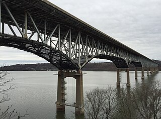
The Millard E. Tydings Memorial Bridge carries Interstate 95 (I-95) over the Susquehanna River between Cecil County and Harford County, Maryland. The toll bridge carries 29 million vehicles annually. It is upstream from the Thomas J. Hatem Memorial Bridge, which carries the parallel U.S. Route 40 (US 40).
Interstate 476 (I-476) is a 132.1-mile (212.6 km) auxiliary Interstate Highway of I-76 in the U.S. state of Pennsylvania. The highway runs from I-95 near Chester north to I-81 near Scranton, serving as the primary north–south Interstate corridor through eastern Pennsylvania. It consists of both the 20-mile (32 km) Mid-County Expressway, locally referred to as the "Blue Route", through Delaware and Montgomery counties in the suburban Philadelphia area, and the tolled, 110.6-mile (178.0 km) Northeast Extension of the Pennsylvania Turnpike, which connects the Delaware Valley with the Lehigh Valley, the Pocono Mountains, and the Wyoming Valley to the north.

Open road tolling (ORT), also called all-electronic tolling, cashless tolling, or free-flow tolling, is the collection of tolls on toll roads without the use of toll booths. An electronic toll collection system is usually used instead. The major advantage to ORT is that users are able to drive through the toll plaza at highway speeds without having to slow down to pay the toll. In some installations, ORT may also reduce congestion at the plazas by allowing more vehicles per hour/per lane.

Interstate 95 (I-95) is an Interstate Highway running along the East Coast of the United States from Miami, Florida, north to the Canada–United States border at Houlton, Maine. In Maryland, the route is a major highway that runs 110.01 miles (177.04 km) diagonally from southwest to northeast, entering from the District of Columbia and Virginia at the Woodrow Wilson Bridge over the Potomac River, northeast to Maryland's border with Delaware near Elkton. It is the longest Interstate Highway within Maryland and is one of the most traveled Interstate Highways in the state, especially between Baltimore and Washington, D.C., despite alternate routes along the corridor, such as the Baltimore–Washington Parkway, U.S. Route 1 (US 1), and US 29. I-95 also has eight auxiliary routes in the state, the most of any state along the I-95 corridor. Portions of the highway, including the Fort McHenry Tunnel and the Millard E. Tydings Memorial Bridge, are tolled.

U.S. Route 1 (US 1) is the easternmost and longest of the major north–south routes of the older 1920s era United States Numbered Highway System, running from Key West, Florida, to Fort Kent, Maine. In the U.S. state of Maryland, it runs 81 miles (130 km) from the Washington, D.C. line to the Pennsylvania state line near the town of Rising Sun.

The Maryland Transportation Authority Police is the eighth-largest law enforcement agency in the U.S. state of Maryland and is charged with providing law enforcement services on Maryland Transportation Authority highways and facilities throughout the Maryland, in addition to contractual services that are provided at Baltimore–Washington International Thurgood Marshall Airport, and the Port of Baltimore.