Cecil County is a county located in the U.S. state of Maryland at the northeastern corner of the state, bordering both Pennsylvania and Delaware. As of the 2020 census, the population was 103,725. The county seat is Elkton.

Havre de Grace, abbreviated HdG, is a city in Harford County, Maryland. It is situated at the mouth of the Susquehanna River and the head of Chesapeake Bay. It is named after the port city of Le Havre, France, which in full was once Le Havre de Grâce.

Interstate 895 (I-895) is an auxiliary Interstate Highway in the US state of Maryland. Known as the Harbor Tunnel Thruway, the highway runs 11.44 miles (18.41 km) between one junction with I-95 in Elkridge and another interchange with I-95 on the east side of Baltimore. I-895 is a toll road that crosses the Patapsco River estuary via the Baltimore Harbor Tunnel, connecting U.S. Route 1 (US 1), I-695, and the Baltimore–Washington Parkway in the southwestern suburbs of Baltimore with US 40 on the east side of Baltimore. In conjunction with a pair of spurs, unsigned I-895A and I-895B, I-895 provides access to the tunnel from I-97 and Maryland Route 2 (MD 2) in Glen Burnie. The highway is designed for through traffic by having partial interchanges that require vehicles from almost all starting points to pass through the tunnel and the tunnel toll plaza, where a $1.40-$6.00 toll is charged to passenger vehicles, before exiting the facility.

The Governor Harry W. Nice Memorial/Senator Thomas "Mac" Middleton Bridge, also known as the Potomac River Bridge, is a 1.7-mile (2.7 km), two-lane continuous truss bridge that spans the Potomac River between Newburg in Charles County, Maryland and Dahlgren in King George County, Virginia, United States. It is one of eight toll facilities operated by the Maryland Transportation Authority, and is one of two toll bridges over the Potomac River. The other, the privately owned Oldtown Low Water Toll Bridge, connects Maryland and West Virginia, far upstream. The new Nice Bridge opened to traffic in October 2022. Demolition of the original bridge began on March 21, 2023.

The Fort McHenry Tunnel is a four-tube, bi-directional tunnel that carries traffic on Interstate 95 (I-95) underneath the Baltimore Harbor. The lowest point in the Interstate System under water, the tunnel is named for nearby Fort McHenry.
The Maryland Transportation Authority (MDTA) is an independent state agency responsible for financing, constructing, operating, and maintaining eight transportation facilities, currently consisting of two toll roads, two tunnels, and four bridges in Maryland. It also provides the Maryland Department of Transportation with financing for other revenue producing transportation projects.

The Francis Scott Key Bridge, also known originally as the Outer Harbor Crossing or simply as the Key Bridge or Beltway Bridge, is a steel arch-shaped continuous through truss bridge spanning the lower Patapsco River and outer Baltimore Harbor / Port carrying Maryland Route 695 in Baltimore, Maryland, United States. The main span of 1,200 feet (366 m) is the third longest span of any continuous truss in the world. It is also the longest bridge in the Baltimore metropolitan area.
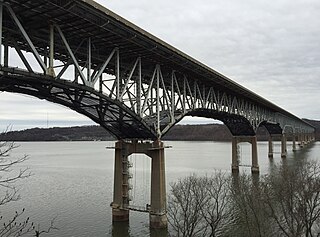
The Millard E. Tydings Memorial Bridge carries Interstate 95 (I-95) over the Susquehanna River between Cecil County and Harford County, Maryland. The toll bridge carries 29 million vehicles annually. It is upstream from the Thomas J. Hatem Memorial Bridge, which carries the parallel U.S. Route 40 (US 40).

Maryland Route 7 (MD 7) is a collection of state highways in the U.S. state of Maryland. Known for much of their length as Philadelphia Road, there are five disjoint mainline sections of the highway totaling 40.23 miles (64.74 km) that parallel U.S. Route 40 (US 40) in Baltimore, Harford, and Cecil counties in northeastern Maryland. The longest section of MD 7 begins at US 40 just east of the city of Baltimore in Rosedale and extends through eastern Baltimore County and southern Harford County to US 40 in Aberdeen. The next segment of the state highway is a C-shaped route through Havre de Grace on the west bank of the Susquehanna River. The third mainline section of MD 7 begins in Perryville on the east bank of the Susquehanna River and ends at US 40 a short distance west of the start of the fourth section, which passes through Charlestown and North East before ending at US 40, just west of Elkton. The fifth segment of the highway begins at South Street and passes through the eastern part of Elkton before reconnecting with US 40 east of Elkton and west of the Delaware state line.

Maryland Route 222 (MD 222) is a state highway in the U.S. state of Maryland. The highway runs 11.36 miles (18.28 km) from MD 7 in Perryville north to U.S. Route 1 (US 1) near Conowingo. MD 222 connects Perryville, Port Deposit, and Conowingo along its route paralleling the Susquehanna River in western Cecil County. Due to limitations in the highway in Port Deposit, including a steep hill and a low-clearance railroad bridge, trucks are directed to use MD 275, MD 276, and US 1 through Woodlawn and Rising Sun to connect Interstate 95 (I-95) with US 222 in Conowingo.
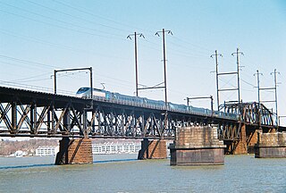
The Amtrak Susquehanna River Bridge is a Howe deck truss structure that carries two tracks of Amtrak's Northeast Corridor line across the Susquehanna River between Havre de Grace and Perryville, Maryland.

The CSX Susquehanna River Bridge is a railroad bridge that carries CSX's Philadelphia Subdivision across the Susquehanna River between Havre de Grace and Perryville, Maryland, via Garrett Island. It was built in 1907-10 by the Baltimore and Ohio Railroad (B&O) on the same alignment as an 1886 B&O bridge. Like its predecessor, it was the longest continuous bridge on the B&O system.

Interstate 95 (I-95) is an Interstate Highway running along the East Coast of the United States from Miami, Florida, north to the Canada–United States border at Houlton, Maine. In Maryland, the route is a major highway that runs 110.01 miles (177.04 km) diagonally from southwest to northeast, entering from the District of Columbia and Virginia at the Woodrow Wilson Bridge over the Potomac River, northeast to Maryland's border with Delaware near Elkton. It is the longest Interstate Highway within Maryland and is one of the most traveled Interstate Highways in the state, especially between Baltimore and Washington, D.C., despite alternate routes along the corridor, such as the Baltimore–Washington Parkway, U.S. Route 1 (US 1), and US 29. I-95 also has eight auxiliary routes in the state, the most of any state along the I-95 corridor. Portions of the highway, including the Fort McHenry Tunnel and the Millard E. Tydings Memorial Bridge, are tolled.

Susquehanna State Park is a public recreation area located on the banks of the lower Susquehanna River north of the city of Havre de Grace, Maryland. The state park's main area is on the west bank of the river; the park also manages land on the river islands and east bank. The park offers fishing, boating, camping, and trails for hiking and equestrian use. It is managed as a complex with Rocks State Park and Palmer State Park by the Maryland Department of Natural Resources.

U.S. Route 1 (US 1) is the easternmost and longest of the major north–south routes of the older 1920s era United States Numbered Highway System, running from Key West, Florida, to Fort Kent, Maine. In the U.S. state of Maryland, it runs 81 miles (130 km) from the Washington, D.C. line to the Pennsylvania state line near the town of Rising Sun.

U.S. Route 40 in the U.S. state of Maryland runs from Garrett County in Western Maryland to Cecil County in the state's northeastern corner. With a total length of 221 miles (356 km), it is the longest numbered highway in Maryland. Almost half of the road overlaps or parallels with Interstate 68 (I-68) or I-70, while the old alignment is generally known as US 40 Alternate, US 40 Scenic, or Maryland Route 144. West of Baltimore, in the Piedmont and Appalachian Mountains / Blue Ridge region of the Western Maryland panhandle of the small state, the portions where it does not overlap an Interstate highway are mostly two-lane roads. The portion northeast of Baltimore going toward Wilmington in northern Delaware and Philadelphia in southeastern Pennsylvania is a four-lane divided highway, known as the Pulaski Highway. This section crosses the Susquehanna River at the north end of the Chesapeake Bay on the Thomas J. Hatem Memorial Bridge.
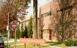
Havre de Grace High School is a four-year public high school in Havre de Grace in Harford County, Maryland, United States. The school is located near the southeast corner of Harford County where the Susquehanna River meets the Chesapeake Bay. The school motto is "Enter to Learn — Leave to Serve."

The Susquehanna and Tidewater Canal between Wrightsville, Pennsylvania, and Havre de Grace, Maryland, at the head of Chesapeake Bay, provided an interstate shipping alternative to 19th-century arks, rafts, and boats plying the difficult waters of the lower Susquehanna River. Built between 1836 and 1840, it ran 43 miles (69 km) along the west bank of the river and rendered obsolete an older, shorter canal along the east bank. Of its total length, 30 miles (48 km) were in Pennsylvania and 13 miles (21 km) in Maryland. Although rivalry between Philadelphia, Pennsylvania, and Baltimore, Maryland, delayed its construction, the finished canal brought increased shipments of coal and other raw materials to both cities from Pennsylvania's interior. Competition from railroads was a large factor in the canal's decline after 1855. Canal remnants, including a lock keeper's house, have been preserved in Maryland, and locks 12 and 15 have been preserved in Pennsylvania.

Maryland Route 155 is a state highway in the U.S. state of Maryland. Known for most of its length as Level Road, the state highway runs 9.06 miles (14.58 km) from MD 22 in Churchville east to U.S. Route 40 and MD 7 in Havre de Grace. In conjunction with MD 22, MD 155 serves as the main highway linking Bel Air and Havre de Grace in eastern Harford County. The state highway also connects Havre de Grace with Interstate 95 (I-95) and Susquehanna State Park. The first portion of MD 155 near Havre de Grace was built by 1910; the remainder of the highway east of Hopewell Village was completed in the mid-1920s. The Churchville–Hopewell Village portion of the state highway, originally designated MD 156, was built in the mid-1930s. MD 155 received its present designation over its western half in 1952 when MD 155 and MD 156 swapped paths.
Thomas J. Hatem was an American politician from Maryland. He served as a member of the Maryland House of Delegates, representing Harford County, from 1955 to 1958. He is the namesake of the Thomas J. Hatem Memorial Bridge.