Beardsley, Minnesota

Last updated

Beardsley
Big Stone County Minnesota Incorporated and Unincorporated areas Beardsley Highlighted.svg
Location of Beardsley, Minnesota
Coordinates: 45°33′28″N96°42′50″W / 45.55778°N 96.71389°W / 45.55778; -96.71389
Country United States
State Minnesota
County Big Stone
Area
[1]
  Total0.47 sq mi (1.23 km2)
  Land0.47 sq mi (1.22 km2)
  Water0.00 sq mi (0.01 km2)
Elevation
[2]
1,096 ft (334 m)
Population
 (2020)
  Total216
  Density459.57/sq mi (177.41/km2)
Time zone UTC-6 (Central (CST))
  Summer (DST) UTC-5 (CDT)
ZIP code
56211
Area code 320
FIPS code 27-04204 [3]
GNIS feature ID2394095 [2]

Beardsley is a city in Big Stone County, Minnesota, United States. The population was 216 at the 2020 census.

Contents

History

Beardsley was platted in 1880 by W. W. Beardsley, and named for him. [4]

Geography

According to the United States Census Bureau, the city has a total area of 0.47 square miles (1.22 km2), all land. [5]

Minnesota State Highways 7 and 28 are two of the main routes in the community.

Climate

Beardsley holds two state monthly record high temperatures, 111 °F or 43.9 °C for September, set in 1931, and 98 °F or 36.7 °C for October, reached in 1963, [6] and shares with Moorhead both the July record and the all-time state high temperature of 115 °F or 46.1 °C, reached in Beardsley on July 29, 1917. [6]

Seismology

Minnesota has a relatively low incidence of earthquakes, with 19 having been documented in the state since 1860, according to the University of Minnesota-Morris. [7] A rare earthquake shook the area on June 5, 1993; the earthquake's epicenter was in the nearby town of Dumont and measured a Magnitude 4.1 and Intensity V-VI. [8] A stronger earthquake (Magnitude 4.6, Intensity VI) struck the area in 1975 and was felt over 315,000 square kilometers. [9]

Demographics

Historical population
CensusPop.Note
1900 449
1910 4817.1%
1920 5075.4%
1930 406−19.9%
1940 53732.3%
1950 435−19.0%
1960 410−5.7%
1970 366−10.7%
1980 344−6.0%
1990 297−13.7%
2000 262−11.8%
2010 233−11.1%
2020 216−7.3%
U.S. Decennial Census [10]

2010 census

As of the census [11] of 2010, there were 233 people, 108 households, and 60 families living in the city. The population density was 495.7 inhabitants per square mile (191.4/km2). There were 141 housing units at an average density of 300.0 per square mile (115.8/km2). The racial makeup of the city was 99.6% White and 0.4% Native American.

There were 108 households, of which 28.7% had children under the age of 18 living with them, 41.7% were married couples living together, 9.3% had a female householder with no husband present, 4.6% had a male householder with no wife present, and 44.4% were non-families. 41.7% of all households were made up of individuals, and 21.3% had someone living alone who was 65 years of age or older. The average household size was 2.16 and the average family size was 2.88.

The median age in the city was 44.8 years. 24.9% of residents were under the age of 18; 7.2% were between the ages of 18 and 24; 18.1% were from 25 to 44; 27.5% were from 45 to 64; and 22.3% were 65 years of age or older. The gender makeup of the city was 47.2% male and 52.8% female.

2000 census

As of the census [3] of 2000, there were 262 people, 125 households, and 71 families living in the city. The population density was 552.4 inhabitants per square mile (213.3/km2). There were 148 housing units at an average density of 312.1 per square mile (120.5/km2). The racial makeup of the city was 100.00% White. Hispanic or Latino of any race were 1.15% of the population.

There were 125 households, out of which 26.4% had children under the age of 18 living with them, 46.4% were married couples living together, 7.2% had a female householder with no husband present, and 42.4% were non-families. 40.8% of all households were made up of individuals, and 25.6% had someone living alone who was 65 years of age or older. The average household size was 2.10 and the average family size was 2.83.

In the city, the population was spread out, with 24.4% under the age of 18, 3.1% from 18 to 24, 22.9% from 25 to 44, 22.9% from 45 to 64, and 26.7% who were 65 years of age or older. The median age was 44 years. For every 100 females, there were 88.5 males. For every 100 females age 18 and over, there were 88.6 males.

The median income for a household in the city was $26,429, and the median income for a family was $33,929. Males had a median income of $26,875 versus $18,750 for females. The per capita income for the city was $16,106. About 6.3% of families and 12.2% of the population were below the poverty line, including 20.3% of those under the age of 18 and 15.5% of those 65 and older.

Related Research Articles

<span class="mw-page-title-main">Clinton, Minnesota</span> Village in Minnesota, United States

Clinton is a city in Big Stone County, Minnesota, United States. The city was named for New York Governor DeWitt Clinton. The population was 386 at the 2020 census.

<span class="mw-page-title-main">Backus, Minnesota</span> City in Minnesota, United States

Backus is a city in Cass County, Minnesota, United States. The population was 250 at the 2010 census. It is part of the Brainerd Micropolitan Statistical Area.

<span class="mw-page-title-main">Hollandale, Minnesota</span> City in Minnesota, United States

Hollandale is a city on State Highway 251 in Freeborn County, Minnesota, United States. The population was 303 at the 2010 census.

<span class="mw-page-title-main">Keewatin, Minnesota</span> City in Minnesota, United States

Keewatin is a city in Itasca County, Minnesota, United States. The population was 1,068 at the 2010 census.

<span class="mw-page-title-main">Regal, Minnesota</span> City in Minnesota, United States

Regal is a city in northeast Kandiyohi County, Minnesota, United States, along the North Fork of the Crow River. The population was 34 at the 2010 census.

<span class="mw-page-title-main">Donaldson, Minnesota</span> City in Minnesota, United States

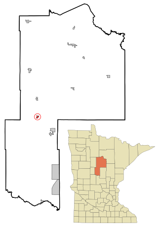
Donaldson is a city in Kittson County, Minnesota, United States. The population was 20 at the 2020 census.

<span class="mw-page-title-main">Harding, Minnesota</span> City in Minnesota, United States

Harding is a city in Morrison County, Minnesota, United States, along the Platte River. The population was 123 at the 2020 census.

<span class="mw-page-title-main">Bluffton, Minnesota</span> City in Minnesota, United States

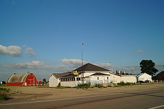
Bluffton is a city in Otter Tail County, Minnesota, United States, along the Leaf River. The population was 210 at the 2020 census.

<span class="mw-page-title-main">Henning, Minnesota</span> City in Minnesota, United States

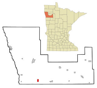
Henning is a city in Otter Tail County, Minnesota, United States. The population was 854 at the 2020 census.

<span class="mw-page-title-main">Vergas, Minnesota</span> City in Minnesota, United States

Vergas is a city in northern Otter Tail County, Minnesota, United States. The population was 348 at the 2020 census.

<span class="mw-page-title-main">Beltrami, Minnesota</span> City in Minnesota, United States

Beltrami is a city in Polk County, Minnesota, United States and was named in honor of Giacomo Costantino Beltrami, an Italian exile, who traveled to the Red river and the upper Mississippi in 1823. Officially incorporated in 1902, there had been settlers in the area since 1870. It is part of the Grand Forks, ND-MN Metropolitan Statistical Area. The population was 88 at the 2020 census.

<span class="mw-page-title-main">Long Beach, Minnesota</span> City in Minnesota, United States

Long Beach is a city in Pope County, Minnesota, United States. The population was 338 at the 2020 census.

<span class="mw-page-title-main">Maplewood, Minnesota</span> City in Minnesota, United States

Maplewood is a city in Ramsey County, Minnesota, United States. The population was 42,088 at the 2020 census. Maplewood is ten minutes' drive from downtown Saint Paul. It stretches along the northern and eastern borders of Saint Paul.

<span class="mw-page-title-main">Leonidas, Minnesota</span> City in Minnesota, United States

Leonidas is a city in Saint Louis County, Minnesota, United States. The population was 52 at the 2010 census.

<span class="mw-page-title-main">Mountain Iron, Minnesota</span> City in Minnesota, United States

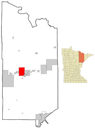
Mountain Iron is a city in Saint Louis County, Minnesota, United States, in the heart of the Mesabi Range. The population was 2,878 at the 2020 census.

<span class="mw-page-title-main">Greenwald, Minnesota</span> City in Minnesota, United States

Greenwald is a city in Stearns County, Minnesota, United States. The population was 222 at the 2010 census. It is part of the St. Cloud Metropolitan Statistical Area.

<span class="mw-page-title-main">St. Rosa, Minnesota</span> City in Minnesota, United States

Saint Rosa is a city in Stearns County, Minnesota, United States. The population was 68 at the 2010 census. It is part of the St. Cloud Metropolitan Statistical Area.

<span class="mw-page-title-main">Altura, Minnesota</span> City in Minnesota, United States

Altura is a city in Winona County, Minnesota, United States. The population was 493 at the 2010 census.

<span class="mw-page-title-main">Fifty Lakes, Minnesota</span> City in Minnesota, United States

Fifty Lakes is a city in Crow Wing County, Minnesota, United States. The population was 387 at the 2010 census. It is part of the Brainerd Micropolitan Statistical Area.

<span class="mw-page-title-main">Ormsby, Minnesota</span> City in Minnesota, United States

Ormsby is a city in Martin and Watonwan counties in the U.S. state of Minnesota. The population was 131 at the 2010 census.

References

  1. "2020 U.S. Gazetteer Files". United States Census Bureau. Retrieved July 24, 2022.
  2. 1 2 U.S. Geological Survey Geographic Names Information System: Beardsley, Minnesota
  3. 1 2 "U.S. Census website". United States Census Bureau . Retrieved January 31, 2008.
  4. Upham, Warren (1920). Minnesota Geographic Names: Their Origin and Historic Significance. Minnesota Historical Society. p.  54.
  5. "US Gazetteer files 2010". United States Census Bureau. Archived from the original on January 25, 2012. Retrieved November 13, 2012.
  6. 1 2 "Monthly State Maximum/Minimum Extremes — 5/31/00" (PDF). National Oceanic and Atmospheric Administration.
  7. Minnesota at a Glance: Earthquakes in Minnesota
  8. U.S. Department of the Interior
  9. U.S. Department of the Interior
  10. "Census of Population and Housing". Census.gov. Retrieved June 4, 2015.
  11. "U.S. Census website". United States Census Bureau . Retrieved November 13, 2012.