Clinton, Minnesota

Last updated

Clinton
Big Stone County Minnesota Incorporated and Unincorporated areas Clinton Highlighted.svg
Location of Clinton, Minnesota
Coordinates: 45°27′47″N96°26′29″W / 45.46306°N 96.44139°W / 45.46306; -96.44139
CountryUnited States
State Minnesota
County Big Stone
Area
[1]
  Total1.04 sq mi (2.70 km2)
  Land0.96 sq mi (2.48 km2)
  Water0.09 sq mi (0.22 km2)
Elevation
[2]
1,161 ft (354 m)
Population
 (2020)
  Total386
  Density403.34/sq mi (155.69/km2)
Time zone UTC-6 (Central (CST))
  Summer (DST) UTC-5 (CDT)
ZIP code
56225
Area code 320
FIPS code 27-11980 [3]
GNIS feature ID2393569 [2]

Clinton is a city in Big Stone County, Minnesota, United States. The city was named for New York Governor DeWitt Clinton. [4] The population was 386 at the 2020 census. [5]

Contents

History

The village was settled about 1877 as Central, Minnesota, with a post office of that name from 1878 to 1885. The name was changed to Clinton in 1885, and the village was platted. The Chicago, Milwaukee and St. Paul Railroad station, named Batavia, was moved to the village in 1885, but the station name was not changed to Clinton until the village was incorporated in 1890. The railroad loading platform, named Rupert, two miles south of the village, was moved to the village in 1890. [6]

Geography

According to the United States Census Bureau, the city has a total area of 1.03 square miles (2.67 km2), of which, 0.95 square miles (2.46 km2) is land and 0.08 square miles (0.21 km2) is water. [7] Clinton is the home to the Big Stone County Fair and Clinton-Graceville-Beardsley Elementary School.

Demographics

Historical population
CensusPop.Note
1900 346
1910 38411.0%
1920 51233.3%
1930 5374.9%
1940 63017.3%
1950 71814.0%
1960 565−21.3%
1970 6087.6%
1980 6222.3%
1990 574−7.7%
2000 453−21.1%
2010 449−0.9%
2020 386−14.0%
U.S. Decennial Census [8]
2020 Census [5]

2010 census

As of the census [9] of 2010, there were 449 people, 201 households, and 115 families residing in the city. The population density was 472.6 inhabitants per square mile (182.5/km2). There were 255 housing units at an average density of 268.4 per square mile (103.6/km2). The racial makeup of the city was 99.6% White and 0.4% from other races. Hispanic or Latino of any race were 1.3% of the population.

There were 201 households, of which 26.9% had children under the age of 18 living with them, 45.8% were married couples living together, 7.5% had a female householder with no husband present, 4.0% had a male householder with no wife present, and 42.8% were non-families. 36.8% of all households were made up of individuals, and 20.4% had someone living alone who was 65 years of age or older. The average household size was 2.21 and the average family size was 2.93.

The median age in the city was 43.6 years. 23.2% of residents were under the age of 18; 6.3% were between the ages of 18 and 24; 21.8% were from 25 to 44; 26% were from 45 to 64; and 22.5% were 65 years of age or older. The gender makeup of the city was 47.7% male and 52.3% female.

2000 census

As of the census [3] of 2000, there were 453 people, 195 households, and 118 families residing in the city. The population density was 471.0 inhabitants per square mile (181.9/km2). There were 230 housing units at an average density of 239.1 per square mile (92.3/km2). The racial makeup of the city was 97.79% White, 1.10% Native American, 0.88% Asian, and 0.22% from two or more races.

There were 195 households, out of which 28.7% had children under the age of 18 living with them, 53.3% were married couples living together, 5.1% had a female householder with no husband present, and 39.0% were non-families. 36.9% of all households were made up of individuals, and 17.9% had someone living alone who was 65 years of age or older. The average household size was 2.29 and the average family size was 3.04.

In the city, the population was spread out, with 25.6% under the age of 18, 8.4% from 18 to 24, 23.4% from 25 to 44, 21.9% from 45 to 64, and 20.8% who were 65 years of age or older. The median age was 40 years. For every 100 females, there were 101.3 males. For every 100 females age 18 and over, there were 92.6 males.

The median income for a household in the city was $31,591, and the median income for a family was $37,273. Males had a median income of $25,938 versus $18,958 for females. The per capita income for the city was $17,469. About 5.8% of families and 13.9% of the population were below the poverty line, including 5.8% of those under age 18 and 8.6% of those age 65 or over.

Attractions

Highway 75 runs through the town, making it relatively accessible to travelers. The former train station is now a history museum.

Clinton is situated adjacent to beautiful Eli Lake. Every year, the world's longest lasting ice golf tournament, the Arctic Open, takes place on this lake. It has been held annually for over 30 years, and typically draws crowds in the hundreds. The Big Stone County Fair is held each summer (usually July) at the Fairgrounds located on the west edge of the city limits. Grandstand events usually consist of demolition derbies, a variety of car races, and most recently, a rodeo. Other attractions are live music, a Carnival, an Old Thyme Tractor Display, as well as multiple 4-H exhibits.

Related Research Articles

<span class="mw-page-title-main">Clinton, Lenawee County, Michigan</span> Village in Michigan, United States

Clinton is a village in Lenawee County in the Irish Hills area of the U.S. state of Michigan. The population was 2,336 at the 2010 census. The village is located within Clinton Township.

<span class="mw-page-title-main">Ramsey, Minnesota</span> City in Minnesota, United States

Ramsey is a suburban city 22 miles (35 km) north-northwest of downtown Minneapolis in Anoka County, Minnesota, United States. The population was 27,646 at the 2020 census. It is a northwest suburb of the Twin Cities.

<span class="mw-page-title-main">Jenkins, Minnesota</span> City in Minnesota, United States

Jenkins is a city in Crow Wing County, Minnesota, United States. The population was 430 at the 2010 census. It is part of the Brainerd Micropolitan Statistical Area.

<span class="mw-page-title-main">Trommald, Minnesota</span> City in Minnesota, United States

Trommald is a city in Crow Wing County, Minnesota, United States. The population was 99 at the 2020 census. It is part of the Brainerd Micropolitan Statistical Area.

<span class="mw-page-title-main">Rushford Village, Minnesota</span> City in Minnesota, United States

Rushford Village is a city in Fillmore County, Minnesota, United States. The population was 807 at the 2010 census. It surrounds the city of Rushford.

<span class="mw-page-title-main">Lancaster, Minnesota</span> City in Minnesota, United States

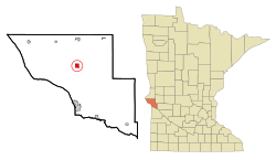
Lancaster is a city in Kittson County, Minnesota, United States. As of the 2020 census, the city population was 364.

<span class="mw-page-title-main">Henning, Minnesota</span> City in Minnesota, United States

Henning is a city in Otter Tail County, Minnesota, United States. The population was 854 at the 2020 census.

<span class="mw-page-title-main">Vergas, Minnesota</span> City in Minnesota, United States

Vergas is a city in northern Otter Tail County, Minnesota, United States. The population was 348 at the 2020 census.

<span class="mw-page-title-main">Henriette, Minnesota</span> City in Minnesota, United States

Henriette, is a city in Pine County, Minnesota, United States. The population was 71 at the 2010 census.

<span class="mw-page-title-main">McIntosh, Minnesota</span> City in Minnesota, United States

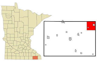
McIntosh is a city in Polk County, Minnesota, United States. It is part of the Grand Forks, ND-MN Metropolitan Statistical Area. The population was 606 at the 2020 census.

Clinton Township is a township in Saint Louis County, Minnesota, United States. Clinton Township was named for Clinton Markell, a prominent settler. The population was 1,015 at the 2010 census.

<span class="mw-page-title-main">Iron Junction, Minnesota</span> City in Minnesota, United States

Iron Junction is a city in Saint Louis County, Minnesota, United States. The population was 110 at the 2020 census.

<span class="mw-page-title-main">Mountain Iron, Minnesota</span> City in Minnesota, United States

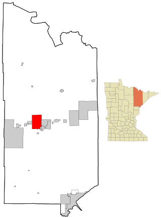
Mountain Iron is a city in Saint Louis County, Minnesota, United States, in the heart of the Mesabi Range. The population was 2,878 at the 2020 census.

<span class="mw-page-title-main">Darfur, Minnesota</span> City in Minnesota, United States

Darfur is a city in Watonwan County, Minnesota, United States. The population was 108 at the 2010 census.

<span class="mw-page-title-main">Rollingstone, Minnesota</span> City in Minnesota, United States

Rollingstone is a city in Winona County, Minnesota, United States. The population was 678 at the 2020 census.

<span class="mw-page-title-main">Clarksville, Ohio</span> Village in Ohio, United States

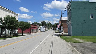
Clarksville is a village in Clinton County, Ohio, United States. The population was 534 at the 2020 census. It is served by the Clinton Massie branch of the Wilmington Public Library of Clinton County.

<span class="mw-page-title-main">Midland, Ohio</span> Village in Ohio, United States

Midland is a village in Clinton County, Ohio, United States. The population was 307 at the 2020 census.

<span class="mw-page-title-main">Clinton, Ohio</span> Village in Ohio, United States

Clinton is a village in southwestern Summit County, Ohio, United States. The population was 1,197 at the 2020 Census. It is part of the Akron metropolitan area.

<span class="mw-page-title-main">Oliver, Wisconsin</span> Village in Wisconsin, United States

Oliver is a village in Douglas County, Wisconsin, United States. The population was 423 at the 2020 census.

<span class="mw-page-title-main">Minnesota Lake, Minnesota</span> City in Minnesota, United States

Minnesota Lake is a city in Blue Earth and Faribault counties in the State of Minnesota. The population was 661 at the 2020 census. The bulk of the city is in Faribault County; a small part extends into Blue Earth County.

References

  1. "2020 U.S. Gazetteer Files". United States Census Bureau. Retrieved July 24, 2022.
  2. 1 2 U.S. Geological Survey Geographic Names Information System: Clinton, Minnesota
  3. 1 2 "U.S. Census website". United States Census Bureau . Retrieved January 31, 2008.
  4. "Profile for Clinton, Minnesota". ePodunk. Archived from the original on May 14, 2019. Retrieved April 26, 2010.
  5. 1 2 "2020 Census Redistricting Data (Public Law 94-171) Summary File". American FactFinder. United States Census Bureau . Retrieved May 1, 2022.
  6. Upham, Warren. Minnesota Place Names: A Geographical Encyclopedia, Third Edition, Revised and Enlarged. [St. Paul, Minn.]: Minnesota Historical Society Press, 2001. ISBN 0-87351-396-7
  7. "US Gazetteer files 2010". United States Census Bureau. Archived from the original on July 2, 2012. Retrieved November 13, 2012.
  8. "Census of Population and Housing". Census.gov. Retrieved June 4, 2015.
  9. "U.S. Census website". United States Census Bureau . Retrieved November 13, 2012.