
Calvert County is located in the U.S. state of Maryland. As of the 2020 census, the population was 92,783. Its county seat is Prince Frederick. The county's name is derived from the family name of the Barons of Baltimore, the proprietors of the English Colony of Maryland Calvert County is included in the Washington–Arlington–Alexandria, DC–VA–MD–WV Metropolitan Statistical Area. It occupies the Calvert Peninsula, which is bordered on the east by Chesapeake Bay and on the west by the Patuxent River. Calvert County is part of the Southern Maryland region. The county has one of the highest median household incomes in the United States. It is one of the older counties in Maryland, after St. Mary's, Kent County and Anne Arundel counties.

Anne Arundel County, also notated as AA or A.A. County, is located in the U.S. state of Maryland. As of the 2020 United States census, its population was 588,261, an increase of just under 10% since 2010. Its county seat is Annapolis, which is also the capital of the state. The county is named for Anne Arundell, Lady Baltimore, a member of the ancient family of Arundells in Cornwall, England, and the wife of Cecilius Calvert, 2nd Baron Baltimore (1605–1675), founder and first lord proprietor of the colony Province of Maryland.

Charles County is located in Southern Maryland. As of the 2020 census, the population was 166,617. The county seat is La Plata. The county was named for Charles Calvert (1637–1715), third Baron Baltimore. Charles County is part of the Washington metropolitan area and the Southern Maryland region.
St. Mary's County, established in 1637, is a county located in the U.S. state of Maryland. As of the 2020 census, the population was 113,777. Its county seat is Leonardtown. The name is in honor of Mary, the mother of Jesus. St. Mary's County comprises the California-Lexington Park, Maryland Metropolitan Statistical Area, which also is included in the Washington-Baltimore-Arlington, DC-MD-VA-WV-PA Combined Statistical Area. It is part of the Southern Maryland region. The county was the home to the first Maryland Colony, and the first capital of the Colony of Maryland. Settled by English Catholics, it is considered to be the birthplace of religious freedom in North America, at a time when the British colonies were settled primarily by Protestants. The county is home to the Patuxent River Naval Air Station and St. Mary's College of Maryland. Traditionally, St. Mary's County has been known for its unique and historic culture of Chesapeake Bay tidewater farming, fishing, and crabbing communities. But with the advent of the military bases, growth of an extensive defense contractor presence, and the growth of St. Mary's College of Maryland, as well as increasing numbers of long-distance Washington, D.C. commuters, it has been undergoing a decades-long transformation which has seen the county's population double since 1970.

Lexington Park is a census-designated place (CDP) in St. Mary's County, Maryland, United States, and the principal community of the Lexington Park, Maryland Micropolitan Statistical Area. The population was 11,626 at the 2010 census.

The Patuxent River is a tributary of the Chesapeake Bay in the state of Maryland. There are three main river drainages for central Maryland: the Potomac River to the west passing through Washington, D.C., the Patapsco River to the northeast passing through Baltimore, and the Patuxent River between the two. The 908-square-mile (2,352 km2) Patuxent watershed had a rapidly growing population of 590,769 in 2000. It is the largest and longest river entirely within Maryland, and its watershed is the largest completely within the state.

Southern Maryland is a geographical, cultural and historic region in Maryland composed of the state's southernmost counties on the Western Shore of the Chesapeake Bay. According to the state of Maryland, the region includes all of Calvert, Charles, and St. Mary's counties and the southern portions of Anne Arundel and Prince George's counties. It is largely coterminous with the region of Maryland that is part of the Washington metropolitan area.

The Battle of Bladensburg was a battle of the Chesapeake Campaign during the War of 1812, fought on 24 August 1814, at Bladensburg, Maryland, 8.6 miles (13.8 km) northeast of Washington, D.C.

The recorded history of Maryland dates back to the beginning of European exploration, starting with the Venetian John Cabot, who explored the coast of North America for the Kingdom of England in 1498. After European settlements had been made to the south and north, the colonial Province of Maryland was granted by King Charles I to Sir George Calvert (1579–1632), his former Secretary of State in 1632, for settlement beginning in March 1634. It was notable for having been established with religious freedom for Roman Catholics, since Calvert had publicly converted to that faith. Like other colonies and settlements of the Chesapeake Bay region, its economy was soon based on tobacco as a commodity crop, highly prized among the English, cultivated primarily by African slave labor, although many young people came from Britain sent as indentured servants or criminal prisoners in the early years.

The Chesapeake Bay Flotilla was a motley collection of barges and gunboats that the United States assembled under the command of Joshua Barney, an 1812 privateer captain, to stall British attacks in the Chesapeake Bay which came to be known as the "Chesapeake Campaign" during the War of 1812. The Flotilla engaged the Royal Navy in several inconclusive battles before Barney was forced to scuttle the vessels themselves on August 22, 1814. The men of the Flotilla then served onshore in the defense of Washington, DC and Baltimore. It was disbanded on February 15, 1815, after the end of the war.

During the American Civil War (1861–1865), Maryland, a slave state, was one of the border states, straddling the South and North. Despite some popular support for the cause of the Confederate States of America, Maryland did not secede during the Civil War. Governor Thomas H. Hicks, despite his early sympathies for the South, helped prevent the state from seceding.
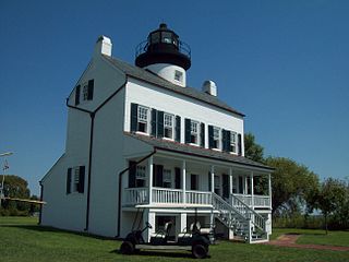
Broomes Island is a small waterfront community and census-designated place (CDP) located at the southern terminus of MD 264 in Calvert County, Maryland, United States, on the Patuxent River. It is located approximately 10 miles (16 km) south of Prince Frederick, the county seat. As of 2019 Census estimates, the population of the CDP was 421.

Maryland Route 231 (MD 231) is a state highway in the U.S. state of Maryland. The state highway runs 16.39 miles (26.38 km) from Olivers Shop Road near Hughesville east to MD 765 in Prince Frederick. MD 231 crosses the Patuxent River on the Benedict Bridge, which connects Benedict in eastern Charles County with Hallowing Point in central Calvert County. The highway directly connects MD 5 in Hughesville with MD 2/MD 4 in Prince Frederick. MD 231 was constructed from Hughesville to Benedict and from Hollowing Point to Prince Frederick in the early 1920s. The portion of the state highway west of Hughesville was built in the early 1930s, about the same time ferry service began between Benedict and Hallowing Point. The Benedict Bridge was started in 1950 and was completed in 1952; the bridge remained the southernmost crossing of the Patuxent River for 25 years. The bridge was tolled from its opening until around 1955. MD 231 was reconstructed between Hughesville and Prince Frederick in the mid- to late 1950s to better serve intercounty traffic.

Croom is an unincorporated community and census-designated place in Southern Prince George's County, Maryland, United States. As of the 2020 census it had a population of 2,720. Croom largely consists of former tobacco farms and forests converted to Washington bedroom subdivisions such as nearby Marlton. The main part of Patuxent River Park is in Croom.
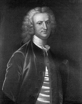
Benedict Swingate Calvert was a planter, politician and a Loyalist in Maryland during the American Revolution. He was the son of Charles Calvert, 5th Baron Baltimore, the third Proprietor Governor of Maryland (1699–1751). His mother's identity is not known, though one source speculates that she was Melusina von der Schulenburg, Countess of Walsingham. As he was illegitimate, he was not able to inherit his father's title or estates, which passed instead to his half brother Frederick Calvert, 6th Baron Baltimore (1731–1771). Benedict Calvert spent most of his life as a politician, judge and planter in Maryland, though Frederick, by contrast, never visited the colony. Calvert became wealthy through proprietarial patronage and became an important colonial official, but he would lose his offices and his political power, though not his land and wealth, during the American Revolution.
The 7th United States Colored Infantry was an infantry regiment that served in the Union Army during the American Civil War. The regiment was composed of African American enlisted men commanded by white officers and was authorized by the Bureau of Colored Troops which was created by the United States War Department on May 22, 1863.
The 9th United States Colored Infantry was an infantry regiment that served in the Union Army during the American Civil War. The regiment was composed of African American enlisted men commanded by white officers and was authorized by the Bureau of Colored Troops which was created by the United States War Department on May 22, 1863.
The 19th United States Colored Infantry was an infantry regiment that served in the Union Army during the American Civil War. The regiment was composed of African American enlisted men, mostly from southern Maryland and that state's Eastern Shore. Commanded by white officers, it was authorized by the Bureau of Colored Troops which was created by the United States War Department on May 22, 1863.
The 30th United States Colored Infantry was an infantry regiment that served in the Union Army during the American Civil War. The regiment was composed of African American enlisted men commanded by white officers and was authorized by the Bureau of Colored Troops which was created by the United States War Department on May 22, 1863.

Agnes Kane Callum was a genealogist known for her research into Maryland's African-American history. She was a founding member of the Baltimore Afro-American Historical and Genealogical Society, a frequent columnist for The Catholic Review, and the founding editor of a black genealogical journal, Flower of the Forest. Callum was inducted into the Maryland Women's Hall of Fame in 2014.


