Indian Head, Maryland

Last updated

Indian Head, Maryland
Flag of Indian Head, Maryland.png
Seal of Indian Head, Maryland.png
Charles County Maryland Incorporated and Unincorporated areas Indian Head Highlighted.svg
Location of Indian Head, Maryland
Coordinates: 38°35′52″N77°9′25″W / 38.59778°N 77.15694°W / 38.59778; -77.15694
Country Flag of the United States.svg  United States of America
State Flag of Maryland.svg  Maryland
County Charles
Incorporated 1920 [1]
Government
  MayorBrandon Paulin
Area
[2]
  Total1.23 sq mi (3.19 km2)
  Land1.23 sq mi (3.19 km2)
  Water0.00 sq mi (0.00 km2)
Elevation
105 ft (32 m)
Population
 (2020)
  Total3,894
  Density3,165.85/sq mi (1,222.53/km2)
Time zone UTC-5 (Eastern (EST))
  Summer (DST) UTC-4 (EDT)
ZIP code
20640
Area code 301, 240
FIPS code 24-41500
GNIS feature ID0590532
Website www.townofindianhead.org

Indian Head is a town in Charles County, Maryland, United States. The population was 3,894 at the 2020 U.S. Census. [3] It has been the site of a naval base specializing in gun and rocket propellants since 1890. [4] Production of nitrocellulose and smokeless powder began at the Indian Head Powder Factory in 1900. [5] The name of the base has varied over the years from Indian Head Proving Ground, to Naval Powder Factory, to Naval Propellant Plant, to Naval Ordnance Station, to the present Naval Support Facility Indian Head. The facility's main tenant activity is the Indian Head Naval Surface Warfare Center (NSWC/IH). Advanced research in energetic systems takes place at NSWC/IH. NSWC/IH absorbed the function of the closed Naval Ordnance Laboratory, formerly in White Oak. The base currently employs 3,700 people.[ citation needed ]

Contents

History

The peninsula, a "head" of land overlooking the Potomac River, had been long occupied by various cultures of indigenous peoples. The historic Algonquian-speaking Native American tribe was the Mattawoman (likely a band of the Piscataway) encountered by the first English settlers; the latter called the land "Indian Head", meaning "Indian Peninsula".[ citation needed ] According to research published by the historical society of Charles County, "Indian Head" is a shortened form of "Indian Headlands". [6] A newspaper article mentions another explanation of the name, that "an unfortunate young brave" from a foreign tribe was beheaded for falling in love with an "Algonquin princess", although Edward W. Rice (the town's mayor at that time) dismissed the story as a "fairy tale". [7]

American Civil War

During the American Civil War, Union Brigadier General Joseph Hooker commanded the Third Brigade near Budd's Ferry in August 1861. The site was a gathering spot for volunteers, including the 5th New Jersey Volunteer Infantry under Colonel Samuel H. Starr. The site was also used by the Union Army Balloon Corps for reconnaissance of Confederate troop movements across the Potomac. [8] [9]

Incorporation

The town of Indian Head was incorporated in 1920. [10] It is located between the Potomac River and Mattawoman Creek on Mattawoman/Cornwallis Neck, named for the 1654 grant of 5,000 acres (20 km2) by Cecil Calvert, 2nd Baron Baltimore, to Capt. Thomas Cornwallis of St. Mary's County. This land grant included the 2,000-acre (8.1 km2) Cornwallis Manor on the Potomac, presumably the Indian Head site, with St. Elizabeth's Manor of 2,000 acres (8.1 km2) "nearby but detached". [11] The Town of Indian Head occupies land that was once part of the territory of the Algonquin Indians. The origin of the name Indian Head originates from the term "Indian Headlands", [12] as the entire lower end of the peninsula was occupied by Native Americans and was an Indian Reservation. The name Indian Head first appears in the Census of 1800. [10] In 1850, the Washington Fruit Growers Association purchased a parcel of land, which included Indian Head and "Glymont". Charles Pye offered for sale, a parcel of land (664 acres) known as Glymont, On December 2, 1834. The same 664 acres was put up for sale again on July 22, 1843, after the death of Charles Pye. The two tracts of land were purchased by The Glymont Improvement Company and recorded on March 20, 1887. The land (540 acres) was owned by B.D. Tubman and was known as "Glymont". The second tract was called “Cornwallis Neck”, and was sometimes known as “Pye’s Wharf Estate”. It adjoined the lands of S. H. Cox and R. A. Chapman, the first-mentioned tract and others containing 480 acres of land, more or less. Glymont, with Pye's Wharf and Leonard Marbury's Wharf, were the largest river port in Charles County. The name "Indian Head" applies to the land west of Glymont. [13]

During the Second World War, Indian Head thrived, with economic prosperity lasting until the late 1960s. [14] The construction of the planned community of St. Charles, south of Waldorf, brought with it retail chains and big-box stores. This resulted in the downfall of Indian Head businesses as Indian Head residents began spending their income in St. Charles. [14]

Indian Head lacks many basic retail and service businesses. [14] [15] [16] Many remedies for this situation have been attempted, but the desired growth has been slow in coming. Indian Head is bisected by Maryland Route 210, generally known as Indian Head Highway. It goes directly into the middle of town at the entrance to Indian Head Naval Support Facility. Because of this, the town cannot benefit from through-traffic, but must be a destination in its own right. [17]

Private plans to build a massive "Chapman's Landing" housing development a few miles to the north were thwarted in the 1990s when the state government purchased the land to preserve it as green space under its "smart growth" program. [18] [19] The preserved land includes an old growth Shell-Marl Ravine Forest ecosystem.

In 2004, the town opened a "black box" stage theater, the Indian Head Center for the Arts Archived May 9, 2008, at the Wayback Machine , [20] and is exploring other efforts to revitalize the town. A section of the railroad to the naval facility, built in 1918, was converted to a 13-mile paved hiking/biking trail in 2008. [21] A year-round swimming pool is at the nearby Henry E. Lackey High School. [22] In 2018 the long-abandoned Elys' store was demolished, and a technology education center called the "Velocity Center" completed in 2020, [23] [24] linked to the Naval base (but with opening delayed due to the COVID-19 Pandemic).

The indigenous Piscataway Conoy Tribe of Maryland consider the name of the town offensive and have petitioned to have the name changed. [25]

Youngest mayor

In 2015, Brandon Paulin was elected mayor of Indian Head. Brandon was 19 years of age when he was elected, making him the youngest mayor of any Maryland municipality in state history. As Vice Mayor, Kiran (Ron) Sitoula is the first Nepali to be elected to a public position outside of Nepal and the first non-US-born official in the history of the Town of Indian Head. [26] Brandon was elected on May 5, 2015, and sworn into office on May 12, 2015. [27]

Geography

Indian Head is located at 38°35′52″N77°9′25″W / 38.59778°N 77.15694°W / 38.59778; -77.15694 (38.597781, -77.156926). [28]

According to the United States Census Bureau, the town has a total area of 1.23 square miles (3.19 km2), all land. [29]

Transportation

MD 210 southbound in Indian Head 2019-05-22 15 13 04 View south along Maryland State Route 210 (Indian Head Highway) at Poplar Lane in Indian Head, Charles County, Maryland.jpg
MD 210 southbound in Indian Head

The main method of transportation to and from Indian Head is by road. The only highway serving the town is Maryland Route 210, the aptly named Indian Head Highway, which connects the town to Washington, D.C., and Interstate 95/Interstate 495 (the Capital Beltway).

Demographics

Historical population
CensusPop.Note
1930 1,240
1940 1,104−11.0%
1950 491−55.5%
1960 78058.9%
1970 1,35073.1%
1980 1,3812.3%
1990 3,531155.7%
2000 3,422−3.1%
2010 3,84412.3%
2020 3,8941.3%
U.S. Decennial Census [30]
2010 [31] 2020 [32]

2020 Census

Indian Head town, Maryland - Demographic Profile
(NH = Non-Hispanic)
Race / EthnicityPop 2010 [31] Pop 2020 [32] % 2010% 2020
White alone (NH)1,33195734.63%24.58%
Black or African American alone (NH)2,1172,34255.07%60.14%
Native American or Alaska Native alone (NH)41391.07%1.00%
Asian alone (NH)100982.60%2.52%
Pacific Islander alone (NH)200.05%0.00%
Some Other Race alone (NH)1100.03%0.26%
Mixed Race/Multi-Racial (NH)1352403.51%6.16%
Hispanic or Latino (any race)1172083.04%5.34%
Total3,8443,894100.00%100.00%

Note: the US Census treats Hispanic/Latino as an ethnic category. This table excludes Latinos from the racial categories and assigns them to a separate category. Hispanics/Latinos can be of any race.

2010 census

As of the census [33] of 2010, there were 3,844 people, 1,391 households, and 995 families residing in the town. The population density was 3,125.2 inhabitants per square mile (1,206.6/km2). There were 1,554 housing units at an average density of 1,263.4 per square mile (487.8/km2). The racial makeup of the town was 35.9% White, 55.5% African American, 1.3% Native American, 2.6% Asian, 0.1% Pacific Islander, 0.8% from other races, and 3.8% from two or more races. Hispanic or Latino of any race were 3.0% of the population.

There were 1,391 households, of which 44.0% had children under the age of 18 living with them, 40.6% were married couples living together, 25.6% had a female householder with no husband present, 5.3% had a male householder with no wife present, and 28.5% were non-families. 22.6% of all households were made up of individuals, and 3.7% had someone living alone who was 65 years of age or older. The average household size was 2.76 and the average family size was 3.24.

The median age in the town was 33.2 years. 28.2% of residents were under the age of 18; 10.5% were between the ages of 18 and 24; 30.4% were from 25 to 44; 23.6% were from 45 to 64; and 7.4% were 65 years of age or older. The gender makeup of the town was 47.3% male and 52.7% female.

2000 census

As of the census [34] of 2000, there were 3,422 people, 1,222 households, and 888 families residing in the town. The population density was 2,792.7 inhabitants per square mile (1,078.3/km2). There were 1,311 housing units at an average density of 1,069.9 per square mile (413.1/km2). The racial makeup of the town was 55.64% White, 38.08% African American, 1.78% Native American, 1.43% Asian, 0.03% Pacific Islander, 0.47% from other races, and 2.57% from two or more races. Hispanic or Latino of any race were 1.69% of the population.

There were 1,222 households, out of which 44.3% had children under the age of 18 living with them, 43.5% were married couples living together, 22.9% had a female householder with no husband present, and 27.3% were non-families. 21.1% of all households were made up of individuals, and 5.8% had someone living alone who was 65 years of age or older. The average household size was 2.80 and the average family size was 3.26.

In the town, the age distribution of the population shows 33.0% under the age of 18, 8.4% from 18 to 24, 34.3% from 25 to 44, 16.7% from 45 to 64, and 7.6% who were 65 years of age or older. The median age was 31 years. For every 100 females, there were 94.3 males. For every 100 females age 18 and over, there were 87.0 males.

The median income for a household in the town was $42,702, and the median income for a family was $48,375. Males had a median income of $35,625 versus $31,451 for females. The per capita income for the town was $18,778. About 9.9% of families and 11.5% of the population were below the poverty line, including 13.9% of those under age 18 and 11.8% of those age 65 or over.

Related Research Articles

<span class="mw-page-title-main">Charles County, Maryland</span> County in Maryland, United States

Charles County is a county located in the U.S. state of Maryland. As of the 2020 census, the population was 166,617. The county seat is La Plata. The county was named for Charles Calvert (1637–1715), third Baron Baltimore. Charles County is part of the Washington metropolitan area and the Southern Maryland region.

<span class="mw-page-title-main">Caroline County, Maryland</span> County in Maryland, United States

Caroline County is a rural county located in the U.S. state of Maryland on its Eastern Shore. As of the 2020 census, the population was 33,293. Its county seat is Denton.

<span class="mw-page-title-main">St. Mary's County, Maryland</span> County in Maryland, United States

St. Mary's County, established in 1637, is a county located in the U.S. state of Maryland. As of the 2020 census, the population was 113,777. Its county seat is Leonardtown. The name is in honor of Mary, the mother of Jesus. St. Mary's County comprises the California-Lexington Park, Maryland Metropolitan Statistical Area, which also is included in the Washington-Baltimore-Arlington, DC-MD-VA-WV-PA Combined Statistical Area. It is part of the Southern Maryland region. The county was the home to the first Maryland Colony, and the first capital of the Colony of Maryland. Settled by English Catholics, it is considered to be the birthplace of religious freedom in North America, at a time when the British colonies were settled primarily by Protestants. The county is home to the Patuxent River Naval Air Station and St. Mary's College of Maryland. Traditionally, St. Mary's County has been known for its unique and historic culture of Chesapeake Bay tidewater farming, fishing, and crabbing communities. But with the advent of the military bases, growth of an extensive defense contractor presence, and the growth of St. Mary's College of Maryland, as well as increasing numbers of long-distance Washington, D.C. commuters, it has been undergoing a decades-long transformation which has seen the county's population double since 1970.

<span class="mw-page-title-main">Somerset County, Maryland</span> County in Maryland, United States

Somerset County is the southernmost county in the U.S. state of Maryland. As of the 2020 census, the population was 24,620, making it the second-least populous county in Maryland. The county seat is Princess Anne.

<span class="mw-page-title-main">Mineral County, West Virginia</span> County in West Virginia, United States

Mineral County is a county in the U.S. state of West Virginia. It is part of the Cumberland metropolitan area, together with Cumberland, Maryland. As of the 2020 census, the population was 26,938. Its county seat is Keyser. The county was founded in 1866.

<span class="mw-page-title-main">Atlantic Beach, Florida</span> City in Florida, United States

Atlantic Beach is a city in Duval County, Florida, United States and the second largest of the Jacksonville Beaches communities. When the majority of communities in Duval County consolidated with Jacksonville in 1968, Atlantic Beach, along with Jacksonville Beach, Neptune Beach, and Baldwin, remained quasi-independent. Like the other towns, it maintains its own municipal government, but its residents vote in the Jacksonville mayoral election and have representation on the Jacksonville city council. The population was 13,513 at the 2020 census.

<span class="mw-page-title-main">Bryans Road, Maryland</span> Census-designated place in Maryland, United States

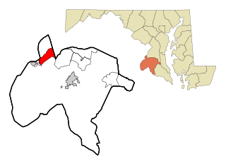
Bryans Road is a census-designated place (CDP) in Charles County, Maryland, United States. Per the 2020 census, the population was 8,650.

<span class="mw-page-title-main">La Plata, Maryland</span> Town in Maryland, United States

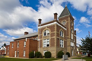
La Plata is a town in Charles County, Maryland, United States. The population was 10,159 at the 2020 census. It is the county seat of Charles County.

<span class="mw-page-title-main">Port Tobacco Village, Maryland</span> Town in Maryland, United States

Port Tobacco, officially Port Tobacco Village, is a town in Charles County, in southern Maryland, United States. The population was 13 at the 2010 census, making Port Tobacco the smallest incorporated town in Maryland.

<span class="mw-page-title-main">Potomac Heights, Maryland</span> Census-designated place in Maryland, United States

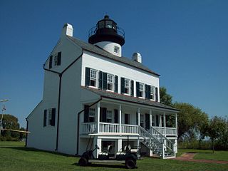
Potomac Heights is a census-designated place (CDP) in Charles County, Maryland, United States. The population was 1,117 at the 2010 census. It has a volunteer fire department and numerous older rambler homes built for workers at the nearby U.S. Navy munitions plant in Indian Head.

<span class="mw-page-title-main">Waldorf, Maryland</span> Census-designated place in Maryland, United States

Waldorf is a census-designated place in Charles County, Maryland, United States. Located 23 miles (37 km) south-southeast of Washington, D.C., Waldorf is part of Southern Maryland. Its population was 81,410 at the 2020 census, making it the fourth-most populous community in the state and the largest community in Southern Maryland. Waldorf has experienced dramatic growth, increasing its population 16-fold from fewer than 5,000 residents in 1980 to its current population. It is now the largest commercial and residential area in Southern Maryland as well as a major suburb in the Washington metropolitan area.

<span class="mw-page-title-main">Brunswick, Maryland</span> City in Maryland

Brunswick is a city in southwestern Frederick County, Maryland, United States. The city is located on the north bank of the Potomac River; Loudoun County, Virginia occupies the opposite shore. The population of Brunswick was 8,211 at the 2022 Census. There are three schools serving Brunswick: Brunswick Elementary School, Brunswick Middle School, and Brunswick High School.

<span class="mw-page-title-main">Poolesville, Maryland</span> Town in Maryland, United States

Poolesville is a U.S. town in the western portion of Montgomery County, Maryland. The population was 5,742 at the 2020 United States Census. It is surrounded by the Montgomery County Agricultural Reserve, and is considered a distant bedroom community for commuters to Washington, D.C.

<span class="mw-page-title-main">Potomac, Maryland</span> Census-designated place in Maryland, United States

Potomac is an unincorporated community and census-designated place in Montgomery County, Maryland, United States. As of the 2020 census, it had a population of 47,018. It is named after the nearby Potomac River. A part of the Washington metropolitan area, many Potomac residents work in nearby Washington, D.C., and Northern Virginia.

<span class="mw-page-title-main">Accokeek, Maryland</span> Census-designated place in Maryland, United States

Accokeek, "at the edge of the hill" in Algonquin, is a census-designated place (CDP) located in Prince George's County, Maryland, United States. The CDP is located on the Potomac River, borders Charles County and is approximately 17 miles from Washington. It is a part of the Washington metropolitan area. The population of the CDP, as of the 2020 United States Census was 13,927.

<span class="mw-page-title-main">Forest Heights, Maryland</span> Town in Maryland

Forest Heights is a town in Prince George's County, Maryland, United States, and is part of the larger postal designation of Oxon Hill. The town straddles both sides of dual-lane Maryland Route 210 and includes two elementary schools. Per the 2020 census, the population was 2,658.

<span class="mw-page-title-main">Fort Washington, Maryland</span> Census-designated place in Maryland

Fort Washington is an unincorporated area and census-designated place in Prince George's County, Maryland, United States. It borders the Potomac River, situated 20 miles south of downtown Washington, D.C. As of the 2020 census, it had a population of 24,261. The Fort Washington community is located west of Maryland Route 210, with some additional area to the east of the highway.

<span class="mw-page-title-main">Leonardtown, Maryland</span> Town in Maryland, United States

Leonardtown is a town in and the county seat of St. Mary's County, Maryland, United States. The population was 4,563 at the 2020 census.

<span class="mw-page-title-main">Great Falls, Virginia</span> Census-designated place in Virginia, United States

Great Falls is a census-designated place in Fairfax County, Virginia, United States. The population at the 2020 census was 15,953.

<span class="mw-page-title-main">Paw Paw, West Virginia</span> Town in West Virginia, United States

Paw Paw is a town in Morgan County, West Virginia, United States. The population was 410 at the 2020 census. The town is known for the nearby Paw Paw Tunnel. Paw Paw was incorporated by the Circuit Court of Morgan County on April 8, 1891, and named after pawpaw, a wild fruit that grows in abundance throughout this region. Paw Paw is the westernmost incorporated community in Morgan County, and the Hagerstown-Martinsburg, MD-WV Metropolitan Statistical Area.

References

  1. "Indian Head". Maryland Manual. Retrieved June 25, 2017.
  2. "2020 U.S. Gazetteer Files". United States Census Bureau. Retrieved April 26, 2022.
  3. "Indian Head town, Maryland, Virginia". United States Census Bureau .
  4. "Indian Head Proving Ground; Where Uncle Sam Tests His Big Guns and Armor Plate". The New York Times. April 15, 1894. Retrieved January 20, 2008.
  5. Worden, Edward C., Nitrocellulose industry: a compendium of the history, chemistry, manufacture, D. Van Nostrand Co., 1911.
  6. Joseph Y. Rowe (April 1990). "The Cornwallis or Mattawoman Neck 1608-1890" (PDF). The Historical Society of Charles County. Retrieved April 28, 2021.
  7. Joshua Partlow (December 25, 2003). "Man Wants 'Indian Head' Changed". The Washington Post. Retrieved April 28, 2021.
  8. Foster, John Y. New Jersey and the Rebellion (1868), pg 130
  9. Budd's Ferry Marker
  10. 1 2 "Town History". Town of Indian Head. Retrieved January 13, 2024.
  11. Wilstach, Paul, Potomac Landings, Doubleday, Garden City, New Jersey, p.69 (1920).
  12. "Our Heritage". Town of Indian Head. Retrieved January 13, 2024.
  13. The Evening Star, December 2, 1834; The Alexandria Gazette, December 23, 1848.
  14. 1 2 3 "Economic Development Opportunities in Indian Head" (PDF). Meet Charles County. Urban Land Institute. Retrieved January 13, 2024.
  15. Ginsberg, Steve (December 31, 1998). "INDIAN HEAD WILL LOSE ITS ONLY GROCERY STORE". The Washington Post . Retrieved January 13, 2024.
  16. N.B. McConaty, "Business attraction is main issue in Indian Head election", Maryland Independent, April 15, 2009
  17. "CHARLES COUNTY, MD: REVITALIZING OUR COMMUNITIES". Meet Charles County. Retrieved January 13, 2024.
  18. Sheilds, Todd (March 17, 1998). "CHAPMAN'S LANDING UNDERWAY". The Washington Post . Retrieved January 13, 2024.
  19. "State Buyout at Chapman's Landing State Purchase". The Baltimore Sun. August 27, 1998. Retrieved January 13, 2024.
  20. "Pumped Up About Premiere". The Washington Post. June 13, 2004.
  21. N.B. McConaty, "Rails to trails project chugs ahead", Maryland Independent, July 23, 2008
  22. "Facility Directory Table List". Charles County. Retrieved January 13, 2024.
  23. "Velocity Center at Indian Head" (PDF). Maryland State Government. Retrieved January 13, 2024.
  24. "Town of Indian Head NEWSLETTER" (PDF). Town of Indian Head. Retrieved January 13, 2024.
  25. "Charles County tribe calls to remove Indian Head name". Southern Maryland News. September 24, 2020. Retrieved April 28, 2021.
  26. "Brandon Paulin, Youngest Mayor in Maryland History, to be Sworn in". May 12, 2015.
  27. "He can't legally buy a beer. But he'll be running a town of 4,000 people. - The Washington Post". The Washington Post .
  28. "US Gazetteer files: 2010, 2000, and 1990". United States Census Bureau. February 12, 2011. Retrieved April 23, 2011.
  29. "US Gazetteer files 2010". United States Census Bureau. Archived from the original on January 12, 2012. Retrieved January 25, 2013.
  30. "Decennial Census by Decade". US Census Bureau.
  31. 1 2 "P2 HISPANIC OR LATINO, AND NOT HISPANIC OR LATINO BY RACE - 2010: DEC Redistricting Data (PL 94-171) - Indian Head town, Maryland". United States Census Bureau .
  32. 1 2 "P2 HISPANIC OR LATINO, AND NOT HISPANIC OR LATINO BY RACE - 2020: DEC Redistricting Data (PL 94-171) - Indian Head town, Maryland". United States Census Bureau .
  33. "U.S. Census website". United States Census Bureau . Retrieved January 25, 2013.
  34. "U.S. Census website". United States Census Bureau . Retrieved January 31, 2008.